Château de Gœulzin: Medieval Fortress and Leisure Residence in France

Site at a Glance
- Rating
- 3.6
- Popularity
- Very Low
- Country
- France
- Primary era
- Early Modern
- Eras represented
- Medieval, Early Modern, Modern
- Civilizations
- French, Spanish
- Site type
- Domestic
- Remains
- Castle
On this page17 sections
History
Château de Gœulzin is a historic castle in France, at Gœulzin near Douai, in the marshy valley of the Sensée. A medieval fortified residence stood here by the late thirteenth century, forming part of the defensive network of Ostrevent, a contested borderland between Flanders, Artois, and Hainaut. The site later evolved from a military stronghold into an agricultural estate and a residence designed for leisure.
Medieval fortress and sixteenth-century damage
The earlier castle was burned during the reign of Philip IV, king of France from 1285 to 1314, and was rebuilt by Enguerrand de Gœulzin. Its first written mention dates from 1310. From the Middle Ages through the sixteenth century, the castle served a defensive purpose in a region where political and military boundaries were frequently contested.
Gœulzin and its castle suffered during the wars and disturbances of the sixteenth century. The village was burned in 1521 and again in 1582, while the castle sustained serious damage. Two inscriptions on the southeast corner tower date its reconstruction to 1576.
The seventeenth-century rebuilding
In the seventeenth century, the lordship passed to the counts of Bucquoy of the Longueval family. Charles-Albert de Longueval, Count of Bucquoy, grand bailiff of Hainaut, and governor of Valenciennes, rebuilt the castle at the beginning of the century on the sandstone foundations of the earlier manor. A grand bailiff was a senior administrative and judicial official with authority over a defined territory.
This rebuilding reduced the defensive emphasis of the complex and strengthened its agricultural role. It also began the transformation of Château de Gœulzin into a residence for leisure. The new building occupied only part of the former castle, leaving sections of the medieval complex outside the rebuilt residence.
The Sensée valley nevertheless retained strategic value during the late reign of Louis XIV. In 1711, French forces commanded by Villars confronted Marlborough’s Anglo-Dutch army across the river. Marlborough captured Bouchain, which Villars retook the following year after the French victory at Denain.
Eighteenth-century country residence
The lordship later passed to the Pronville family, who sold it in the middle of the eighteenth century to Pierre Taffin. He was procureur général of the Provincial Council of Hainaut, a senior legal officer representing the public interest before a governing or judicial body, and an administrator of the Anzin coal mines.
Jean-Charles-Louis Taffin, Pierre Taffin’s fourteenth child, added a combined icehouse and dovecote tower near the outbuildings in 1763. An icehouse stored naturally harvested ice, while a dovecote housed pigeons. He also rebuilt the church in 1771. These works further established the property as a château de plaisance, or country residence intended for leisure.
Between the 1760s and 1770s, the principal building was altered with a continuous balcony along the south wing. New French doors opened onto the balcony, and broad arched windows were inserted into the raised basement. The icehouse and dovecote later lost their original functions after industrially produced ice became available in the nineteenth century, and the tower was eventually abandoned.
Nineteenth-century landscape and modernization
The hydraulic system around the castle was improved throughout the nineteenth century. During the First Empire, the regime of Napoleon I, the irrigation of the land south of the castle was substantially expanded and regularized before 1812. This system formed part of the managed landscape surrounding the residence.
Louis Taffin d’Heursel probably modernized the castle during the Second Empire, the regime of Napoleon III. He installed a flamboyant neo-Gothic gallery from a convent in Metz and added a corner niche for a statue. A terrace and monumental entrance steps were probably constructed during the same period.
Before 1866, a large park was created with a water body fed by the Sensée and islands linked by bridges. The landscaped area resulted from changes to the irrigation system and to some of the land it had previously served. The masonry sidewalls of the ditch south of the outbuildings probably also belong to this phase.
War damage, decline, and protection
After Louis Taffin’s death, the castle collections were sold at public auction. Georges Lambrecht, mayor of Gœulzin from 1908 to 1912, later lived at the castle after the departure of his aunt, Louis Taffin’s wife.
German troops occupied Château de Gœulzin during the First World War. The castle was looted and abandoned, and its ruined condition dates from this period. After the war, the moats were apparently drained on three sides, while the northern channel beside the outbuildings was filled beyond the northern access bridge.
The outbuildings were later divided between two properties. The current owners acquired the castle and part of the outbuildings and undertook extensive clearance of trees, shrubs, and ivy from the masonry to limit further deterioration. The ruins were listed as a historic monument on 3 August 2007. The icehouse and dovecote tower had already been entered on the supplementary inventory of historic monuments by an order dated 3 December 2002.
Remains
Fortified platform and water system
The medieval manor occupied a rectangular platform measuring about 20 by 40 metres at an elevation of approximately 33 metres, on a terrace above marshy low ground. Broad moats, between 10 and 15 metres wide, surrounded the platform. A diversion of the Sensée supplied water to the moats around both the castle and the lower court, isolating these areas and the park.
West of the manor stood a trapezoidal outer enclosure measuring about 110 by 80 metres. Ditches surrounded this lower court of the fortified seigneurial residence, which contained farm buildings, meadows, gardens, and open areas. An associated irrigation network served the land south of the castle. It existed by the beginning of the nineteenth century and probably originated earlier.
Seventeenth-century residential wings
South wing
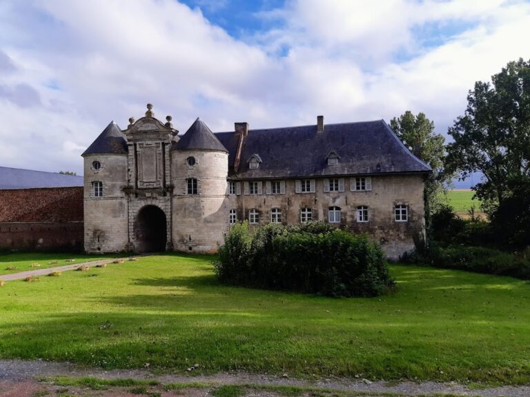
The rebuilt residence has an L-shaped plan formed by two rectangular wings set at right angles. The southern wing has two round towers on its south side, each formerly capped by a pepper-pot roof, a small conical roof over a round tower. The wing contains two full stories and an attic above a substantial raised substructure pierced by openings. It survives in fairly good condition up to the first-floor string course.
The south facade once had French doors opening onto a balcony that extended almost its entire length. The balcony projected considerably from the wall, rested on simple iron brackets, and had a wrought-iron balustrade. Some of the brackets remain.
The facade follows a tripartite arrangement. Its central bay contained a ground-floor window with a curved pediment, two rectangular windows, and a large dormer with a curved pediment. The dormer carried a shield bearing heraldic arms. Two groups of two bays flanked the center, and each group ended in a Flemish stepped gable, whose edges rise in successive steps, with an opening lighting the upper loft.
Long return wing
The west side of the southern wing retains a similar stepped gable, positioned on the front wall at the level of the second-floor window sills. Its return toward the inner courtyard survives only at ground-floor level across two bays. On the courtyard side, sandstone masonry rises to the sills of the first-floor windows.
The longer wing extends northward and has two full stories beneath an attic whose form is unknown. Its facade contains four irregularly spaced rectangular window bays, followed by an isolated French door between broad wall piers. The door forms a central feature that does not project from the wall.
This opening is framed by rusticated false pilasters, which imitate block masonry, together with a carved keystone showing a head and a triangular pediment. Two further bays are arranged symmetrically around the central feature. The design probably represents an unfinished project that would have extended the wing by two additional bays to meet the base of the former northeast corner tower.
Most of the long facade remains, although several first-floor wall piers have collapsed. At its northern end, a two-level facade survived with a Flemish stepped gable, but the gable has disappeared completely.
Courtyard towers and gallery
Octagonal stair towers
The courtyard facade of the long wing was flanked by two octagonal towers that predated the seventeenth-century rebuilding. The smaller tower, positioned in the angle between the residential wings, housed a staircase. The larger brick tower, reinforced with stone chainwork, stood near the end of the long wing and probably contained a second staircase.
Between these towers, the facade had two full stories and four bays beneath a tall roof. Three arched dormers illuminated the roof. They had projecting central keystones and curved cornices, forms associated with brick-and-stone construction in the first quarter of the seventeenth century in Île-de-France and Normandy.
Neo-Gothic gallery and terrace
A flamboyant neo-Gothic gallery from the Grands Carmes convent in Metz was reassembled between the towers. It formed a transition between the residential rooms and a winter garden. A large terrace preceded the gallery, while monumental entrance steps were supported by cellars with barrel-vaulted ceilings.
Only the terrace substructure and two levels of the large tower remain in this area. The rest has been demolished. The roofs of the two large towers survived until relatively recently before collapsing inside their walls, along with additional masonry that had filled the already-collapsed substructure.
Lower court and outbuildings
The former lower court and its outbuildings occupy a broad trapezoidal area on an east-west axis. Before the French Revolution, the complex contained two courtyards crossed lengthwise by a passage. Between 1812 and 1866, the eastern enclosure toward the castle had disappeared, as had the southwest wing of the second courtyard. Later alterations destroyed part of the wing west of the second courtyard and a small section on its southern side.
The surviving outbuildings are divided by a private lane. The southern buildings form a T-shaped group and serve as the principal residence of Serge and Mrs. Nal, who also own the castle. The northern section, twice as large, and the icehouse and dovecote tower belong to Éric and Mrs. Dupire.
Icehouse and dovecote tower
The combined icehouse and dovecote tower has an unusual plan that joins two otherwise separate functions. Its date, 1763, appears on the tower lintel. The structure is now roofless. Its original uses ended after the development of industrial ice production in the nineteenth century, after which it was abandoned.
Surviving grounds and hunting pavilion
The ruins expose the exterior walls, three towers, and the principal facade with its Flemish stepped gables. The present property covers 3.5 hectares of the castle’s historical 25 hectares. It includes a two-hectare hunting wood and most of the Gœulzin pond.
The manor of the former hunting pavilion is now the principal residence. It consists of a ground-floor building with an upper story and a central tower. Its composition includes a gable described as Wembergues, a chimney on the right, and a terrace on the left.