Castle of Alpuente: A Frontier Fortress in Valencia, Spain


Site at a Glance
- Rating
- 4.3
- Popularity
- Very Low
- Country
- Spain
- Primary era
- Medieval
- Eras represented
- Medieval, Modern
- Civilizations
- Crown of Aragon, Umayyad
- Site type
- Military
- Remains
- Castle
On this page19 sections
History
The Castle of Alpuente is a Muslim fortress in Alpuente, Spain, possibly founded in the tenth century as a caliphal stronghold, meaning a fortification associated with an early Islamic caliphate. Built on a rocky height above the town, it controlled the surrounding area and later became a refuge when Alpuente’s town walls could no longer withstand attack.
Muslim origins and Christian frontier
If the oldest surviving structures are correctly identified as caliphal, the fortress may have been established in the tenth century. Its position gave it strategic value over the surrounding lands. It may also have held a hierarchical relationship with the Castle of Poyo or Collado, about 10 kilometres to the north, from which the lands of Teruel could be viewed more effectively.
After the Christian conquest of Valencia, the fortress continued in use because Alpuente lay on the frontier between Aragón and Castile. The castle underwent extensive changes during the Wars of the Union in the fourteenth century, a series of conflicts involving the political communities and royal authority of the Crown of Aragón.
Medieval trade and warfare
During the fourteenth and fifteenth centuries, Alpuente’s importance was connected partly with its position at the entrance to a royal livestock route. This legally recognized route carried herds, especially sheep, between seasonal pastures, and the town collected tolls from the traffic. The frontier setting also exposed Alpuente to repeated conflict with the Kingdom of Castile, and the castle remained involved in these wars until the fifteenth century.
Destruction and Carlist occupation
After the War of the Spanish Succession, Philip V’s Bourbon claim to the Spanish throne prevailed over the Austrian-backed Habsburg claimant, a member of the major European ruling dynasty. Because Alpuente had supported the Habsburg cause, the castle was ordered to be destroyed in retaliation. It was later reconstructed during the Carlist Wars, the nineteenth-century civil conflicts between supporters of the Carlist claim to the throne and liberal governments.
After the First Carlist War, another demolition was ordered to prevent the castle from being reused as a stronghold by Carlist forces. In 1835, however, Carlist troops under the commander Cabrera occupied Alpuente even though the upper part of the castle had already been dismantled or had fallen into ruin. The troops used the underground spaces and strengthened the citadel, a fortified inner defensive area, with four batteries.
The fortress withstood a siege by liberal troops commanded by General Azpiroz. The fighting destroyed many houses and a substantial part of the parish church. Alpuente was occupied again during the Third Carlist War. These military events caused the practical destruction of the fortress, while natural deterioration and the removal of building materials for private construction deepened the damage from the mid-nineteenth century onward.
Archaeological history and protection
Excavations have revealed medieval and earlier remains within the fortress, including dwellings from the eleventh to thirteenth centuries and at least one former interior room. The ruins preserve archaeological information beneath and among the collapsed structures. The Castle of Alpuente and the town walls were jointly designated a Spanish Asset of Cultural Interest in the monument category in 2001, under identifier RI-51-0010655.
Remains
The castle occupies a narrow rocky promontory approximately 250 metres long and 16 metres wide. It rises about 50 metres above the town, while its eastern side drops in near-vertical cliffs for approximately 150 metres toward the narrow channel of the Reguero. The opposite slope descends vertically toward the Reguero ravine by about 105 metres. The surviving complex includes perimeter-wall sections, tower foundations, interior structures, underground rooms and passageways, and scattered remains on the mountain slopes.
Approach and outer defenses
Ramped approach
Access followed a narrow path cut into the mountain and passed through three successive gates. The approach began with a ramp probably more than 3 metres wide, surfaced with carefully prepared paving that allowed horses and perhaps small carts to pass. In its final phase, a high parapet may have transformed the ramp into a covered way.
Barbican and external tower
The route continued to the remains of the barbican gate, an advanced defensive enclosure protecting an entrance. From there, it led toward an ancient external albarrana tower, a defensive tower projecting beyond the main wall, which dates to the caliphal period. Medieval changes can be seen in the tower, together with damage caused by a mine during the Carlist Wars.
Moat and medieval gate
The path zigzagged upward to the upper platform of the barbican. To its north are the moat and the remains of a medieval gate that was still functioning in the nineteenth century. Caliphal-period masonry in this area indicates that an earlier defensive system once closed the approach.
Upper castle structures
Beyond the barbican, an open area extends along the lower part of the castle. A sequence of underground structures was built against the Muslim wall, which was later heightened by a late-medieval construction. Above-ground structures survive between these spaces and the rock face. In a northern open area, large late-medieval cisterns occupy part of the complex, while excavations on at least the western side have exposed dwellings dating from the eleventh to thirteenth centuries. A substantial rock outcrop occupies the eastern side.
Torre de la Veleta
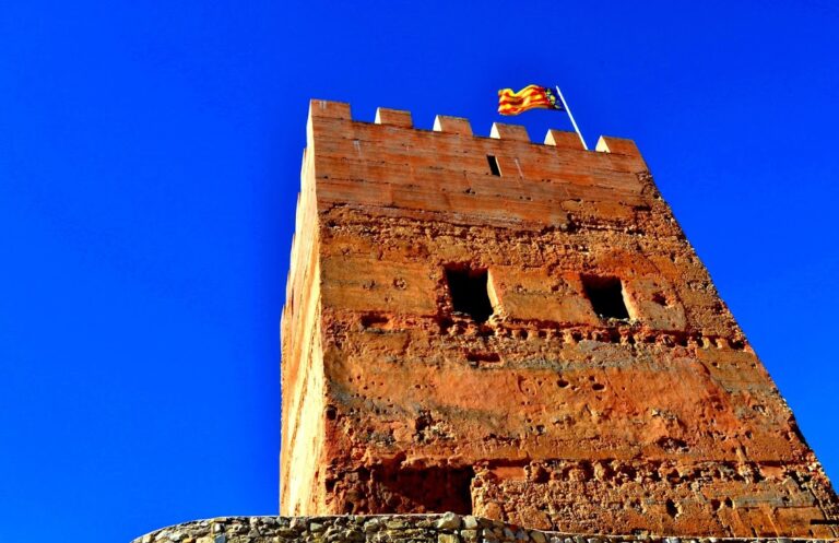
The southern part of the castle, near the parish church, is the best-preserved area. It contains the Torre de la Veleta, also known as the Tower of Homage. This massive tower was built from cut stone blocks and remains approximately 10 metres high despite repeated demolitions.
Underground rooms and cisterns
Much of the upper castle was constructed over underground spaces. At least on the northern side, these were vaulted cisterns fitted with vents and access wells and coated with red ochre. After their use as cisterns ended, doors were opened, partition walls were demolished, and new masonry walls were built during the modern period.
Excavated room
Rooms stood above the underground structures. One excavated room had floors made with lime mortar and walls formed from varied masonry, including rubblework and small cut-stone blocks in the caliphal style. The walls were finished with carefully made lime plaster.
Town walls and entrance tower
The Muslim wall enclosed the medieval town and ran for approximately 600 metres along its western slope, from the Portillo in the south toward the Reguero ravine in the north. On the eastern side, the steep natural slope of the castle hill completed the enclosure. The wall included fourteen towers described as six to eight metres thick. Numerous wall sections and tower bases survive, although many are seriously deteriorated. Because the wall divided the town into two parts, it underwent repeated adaptations, and two tower remains were destroyed in the late twentieth century when streets were widened.
Torre Aljama
The best-preserved town-wall tower is the Torre Aljama, which formed the principal entrance to the walled enclosure. It also provided defense and refuge for inhabitants living outside the walls during periods of danger. The surviving rectangular building is approximately 16 metres high, crowned with battlements and entered through a semicircular arch built from cut stone. Its upper floor housed the commercial exchange and town hall. A council chamber was added in the sixteenth century, and the building served as the town hall until 2012.
Carlist military installations
Carlist defenses included an outer wall approximately 0.5 metres thick and 2 metres high, forming a circuit of about 400 to 500 metres. A counter-ditch, an external defensive ditch, separated it from a second wall of similar dimensions. The main approach led to a first courtyard flanked by stables and sheds used by the garrison and for prisoners and hostages.
The military layout also contained quarters for the governor and fortress commander, a second courtyard or citadel, ground-floor dungeons, a bread oven, and a field printing press for issuing bulletins. The unfinished citadel had four batteries oriented toward the four cardinal directions. The batteries were formed by broad parapets, internal vertical retaining walls, and external slopes made from earth or masonry. Four batteries are mentioned, and two have so far been identified.
Workshops and powder magazine
The first courtyard contained carpentry and locksmith workshops, a storehouse, espadrilles, and masonry tools. A powder magazine was cut into the rock and reached by a spiral descent. It held cannon and rifle ammunition, while eight men worked continuously there to produce cartridges.
Rock-cut basins
Outside the fortified enclosure, at the base of the castle rock, six hemispherical basins were cut into the stone and finished with bush-hammering. They may have been used in the manufacture of ammunition, adding a production function to the military installations around the fortress.