Caulonia: A Greek City of Magna Graecia in Southern Italy
Site at a Glance
- Popularity
- High
- Country
- Italy
- Primary era
- Classical
- Eras represented
- Iron Age, Classical
- Civilizations
- Ancient Greek
- Site type
- City
On this page25 sections
History
Caulonia was an ancient Greek city on the Ionian coast of Calabria, Italy. It belonged to Magna Graecia, the Greek settlements and communities of southern Italy and Sicily. Its precise foundation date is unknown, but finds indicate activity in the eighth century BC and a settled Greek presence by the late eighth or early seventh century BC.
Greek foundations and early conflicts
Traditions about the city’s beginnings name Greek settlers from Achaea led by Typhon of Aegium. Another account describes Caulonia as a colony of Croton. The stories may be compatible: Croton could have invited the settlers or their leader. Croton may also have conquered Caulonia between 675 and 650 BC, perhaps to prevent attacks from Locri. Its influence was associated with Caulonia’s prosperity in the sixth century BC, although the city’s coins from that century indicate that it was then independent.
A foundation myth gives the city a different origin. Kaulon, son of the Amazon Clete, was said to have survived the destruction of his mother’s kingdom by the Achaeans, who were aided by Croton, and to have rebuilt the city. The name Caulonia has also been connected with words meaning “deep valley” or “stem” or “trunk.”
In the sixth century BC, Caulonia joined Croton in a battle on the Sagra River against the Greek city-states of Locri Epizefiri and Rhegion. The allies were defeated, Caulonia was captured, and many people died. Legend credited the Dioscuri, the twin figures Castor and Pollux, with determining the battle’s outcome.
During the Peloponnesian War (431–404 BC), Caulonia supplied Athens with timber for ships. Syracusan forces attacked the city and burned its timber stores. The city’s maritime activity also involved a double landing place at the mouth of the Assi River. It had access to stone, magnesia, salt, gold, and lead, and may have produced metal goods and pottery.
Destruction and refoundation
In 389 BC, forces combining Lucanians with those of Dionysius I, ruler of Syracuse, defeated Caulonia. The city was razed, its territory given to Locri, an ally of Dionysius, and its people deported to Sicily. At Syracuse, the deportees received citizenship and an exemption from taxes for five years. Dionysius II, the son and successor of Dionysius I, later refounded Caulonia and probably placed it under Locrian control.
Caulonia was destroyed again during the Pyrrhic War (280–275 BC), Rome’s conflict with Pyrrhus of Epirus and his allies in southern Italy. Campanians, people from southern Italy, took the city while serving as Roman allies. During the Second Punic War (218–201 BC), the war between Rome and Carthage, Caulonia sided with Hannibal, the Carthaginian commander, and fell to him. Rome brought it under its control by 205 BC, then Roman forces destroyed it around 200 BC. The coastal city was probably abandoned at about that time.
Roman maritime itineraries later used the name Stilida for the locality. In 1863, a town about 15 kilometres away, then called Castelvetere, adopted the name Caulonia in honor of the ancient city. The change reflected the mistaken belief that the ancient settlement had stood within the town’s territory.
Identification and archaeological work
Paolo Orsi identified the ancient site in 1891 and directed its first excavations, carried out from 1911 to 1913. Railway construction exposed masonry remains in 1941. Excavations led by Elena Tommasello in 1970–71 added to the evidence for the city’s buildings and sanctuary.
Work begun in 1999 by the Scuola Normale Superiore and the University of Pisa uncovered much of the urban sanctuary. It clarified the site’s development, from its first monumental phase in the first half of the seventh century BC to decline in the opening decades of the third century BC. The findings also overturned an earlier attribution of the temple’s construction to craftsmen from Syracuse. Eight field campaigns led by Maria Cecilia Parra and M. T. Iannelli followed between 2001 and 2006.
Excavations beginning in 2007 yielded a stone dedication fragment, reported in June 2008. Its text is in Oscan, an ancient Italic language, written with Greek-derived letters, and honors an Italic goddess corresponding to Venus in Roman religion. A large mosaic was discovered in 2013. In December of that year, storms and rough seas damaged the casemate remains and other coastal ruins. A sea defense for the Doric temple was built in 2015.
Remains
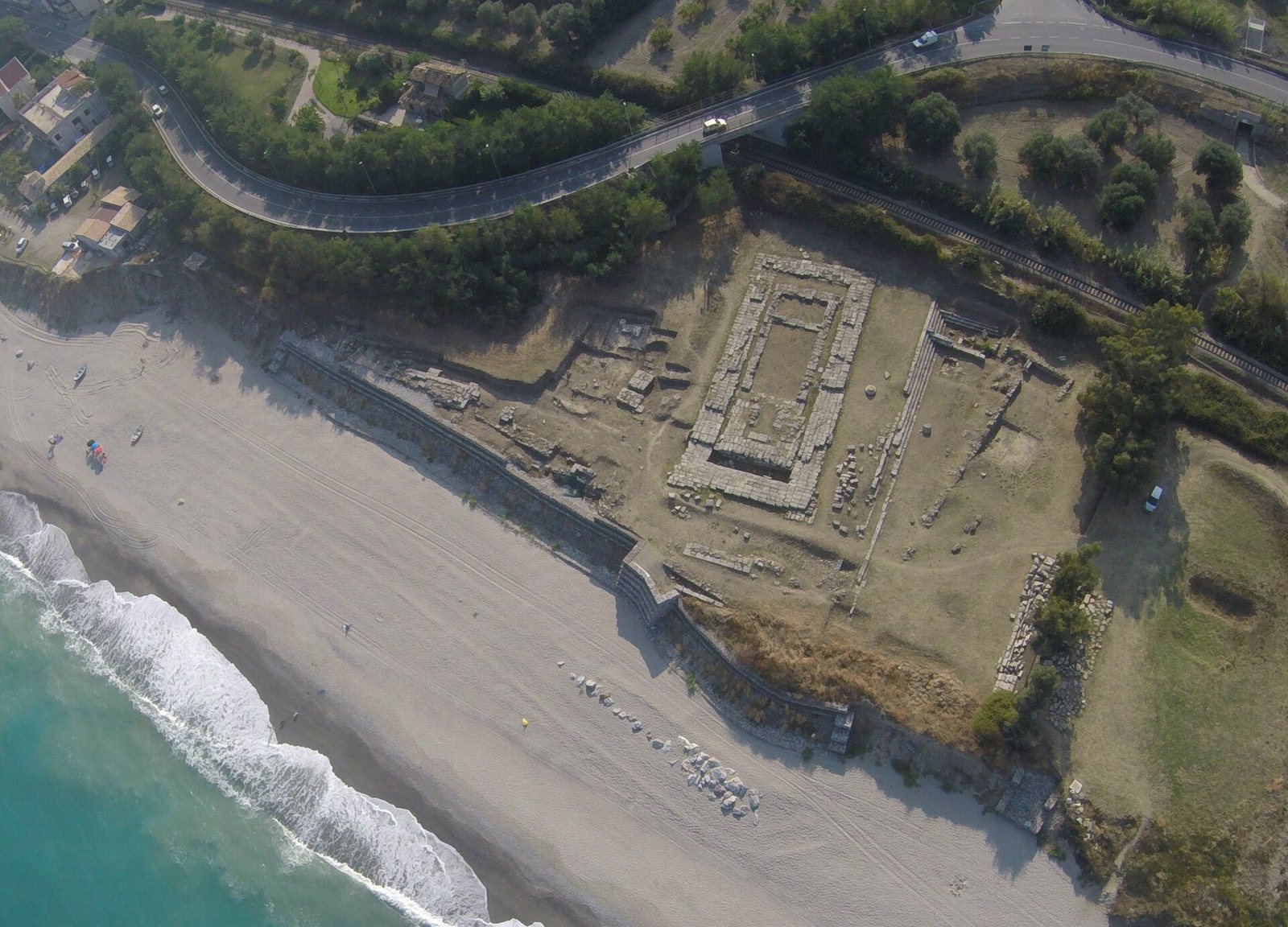
The walled settlement lay between the mouths of the Stilaro River to the south and the Assi River to the north, with the curved headland of Punta Stilo immediately to the north. Its main urban center stood near sea level. Within the walls were defensive structures, a sanctuary, and residential areas; other cult sites lay beyond the city. The visible remains reflect several periods of construction and use.
City walls and coastline
Walls, gates, and towers
The city walls enclosed an area estimated at about 40 hectares. Visible stretches of the defenses include gates and towers with rectangular bases. Construction took place in four phases: the seventh to sixth centuries BC, the late sixth century BC, the fifth century BC, and the fourth to third centuries BC.
The headland and submerged columns
In antiquity, the shoreline lay about 300 metres farther seaward than it does today. More than a hundred fluted columns found on the seabed once stood on the broad, curved headland. An underwater expedition in 1982 identified Greek columns at a depth of 50 metres. The coastline began to recede around 400 BC, a process attributed to uplift of the land and submergence of the seabed. The change continued until the first century AD, after which the shoreline remained stable.
The urban sanctuary
The Doric temple
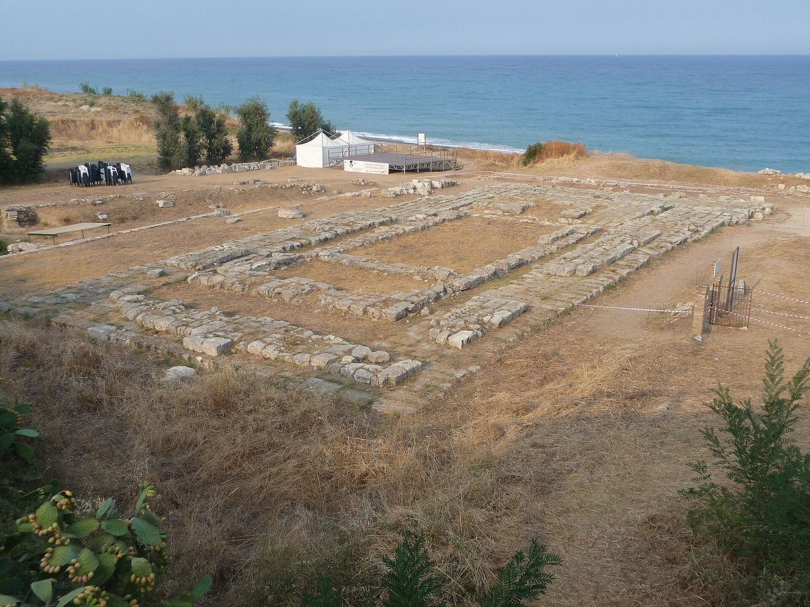
The sanctuary’s main building was a Doric temple, in a Greek architectural style. Built of locally quarried sandstone around 450 BC, it measured 41.20 by 18.20 metres. Its plan called for six columns across the front and fourteen along each side. Marble roof tiles came from the island of Paros in the Cyclades. The temple’s foundations remain visible.
Offerings and the sanctuary inscription
Smaller altars stood in the sanctuary, where stone cult markers and offering tables were also found. More than 180 weapons came from the area, some intact and others in fragments. The sanctuary’s certain cults included Aphrodite and Zeus. Bronze laurel leaves suggest worship of Apollo, who also appeared on Caulonian silver coins. A fifth-century BC bronze tablet carries an eighteen-line dedication to Zeus in the Achaean alphabet, a local form of Greek writing used by Achaean communities. Its letters are arranged in aligned rows and columns. The inscription is the longest known Achaean text from Magna Graecia and also mentions Artemis, the Muses, and the Graces.
A carved cornice fragment
A separate cornice fragment found after storms in 2013–14 is made of fine white calcarenite, a limestone formed mainly from sand-sized carbonate grains. It measures 88.5 centimetres long, 68.15 centimetres wide, and 47.2 centimetres high. A projecting roof block associated with the fragment carries three rows of six ornamental drops, each 4.4 centimetres across. The piece may belong to another building in the Doric style.
Cult sites beyond the walls
Tersinale
The hill of Tersinale held another important cult center. Finds from offerings there include terracotta architectural pieces attributed to three phases of a small temple. They comprise recessed ceiling panels, fragments from the triangular roof ends and roof edges, lion-head rain spouts, and ornaments from the roof peak and corners.
Passoliera
The Passoliera sanctuary lies about 200 metres southwest of the city walls. Orsi discovered it, and finds include pottery dating from the late sixth to the middle of the fifth century BC. Eighth-century BC pottery points to activity at the site before the city was founded.
Punta Stilo
On the hill of the Punta Stilo lighthouse, Orsi identified limited remains of a probable Archaic-period temple. Its dedication has been tentatively associated with Poseidon or Apollo.
Houses and urban areas
The casemate area
The remains called the casemate include a protected chamber built into a fortification, along with traces of houses. Coins and evidence of a cult of Demeter have also been found in the area.
The House of the Dragon
The House of the Dragon measures 17 by 35 metres. Its floor mosaic depicts a sea dragon and later became a symbol of Caulonia. First found in 1969, the mosaic was restored and transferred to the Monasterace Archaeological Museum in 2012, where it is displayed.
A second dragon mosaic
A second mosaic depicting a dragon came from a building thought to have been a bathhouse. Dating to the late fourth century BC, it covers about 25 square metres. Its design contains nine multicolored squares and a separate area at the room entrance with a multicolored rosette. This mosaic is also displayed at the Monasterace Archaeological Museum.
The San Marco northeast area
The San Marco northeast excavation area is bounded by the Ionian Sea to the east, the railway to the west, the Assi River to the north, and the casemate area to the south. A north–south road, 6.65 metres wide, was identified near the House of the Grotesque Figure, which belongs to a later, affluent domestic phase in this area. Other identified houses include the House of the Insula, Guarnaccia House, and Clete’s House. A large building from the Hellenistic period, the era following Alexander the Great’s conquests, dates to the third century BC and extends partly beneath present-day State Road 106, limiting its excavation. A small cemetery dating to the sixth and seventh centuries AD was also found here.
Settlements in the surrounding area
Rural settlements along the Stilaro
A regional survey covered 56 square kilometres across Monasterace, Stilo, Camini, and Guardavalle. It identified seven small Greek settlements of the seventh and sixth centuries BC on the right bank of the Stilaro, interpreted as farms. Most occupied elevated ground and lay about 1,000 metres apart, although the spacing differed at Franchi and Serre. The Franchi settlement stood in a high position with natural defensive advantages.
Fontanelle
At Fontanelle, on the Stilaro’s left bank, remains of a Roman villa occur alongside evidence of Greek settlement dating to the sixth century BC.
Jeritano
At Jeritano in Camini, about eight kilometres from Caulonia, a Greek tomb dating to around 350 BC was identified. The tomb is now held at the National Museum of Magna Graecia, and the area where it was found is considered one of Caulonia’s burial grounds.