Castillo de Roita: A Medieval Fortress in Aragón


Site at a Glance
- Rating
- 5
- Popularity
- Very Low
- Country
- Spain
- Primary era
- Medieval
- Eras represented
- Medieval
- Civilizations
- Crown of Aragon, Kingdom of Navarre, Umayyad
- Site type
- Military
- Remains
- Castle
On this page8 sections
History
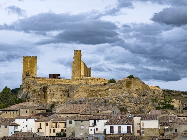
Castillo de Roita is a medieval fortress in Spain, located in the municipality of Sos del Rey Católico in Zaragoza. Known during the Muslim period as Charat-Kachtilla or Xera Caxtila, it occupied a strategic position between Isuerre and Urriés and was associated with a settlement that later became depopulated. The site should not be confused with Carcastillo in Navarre or with Ruesta and Serracastillo. Its present name, also recorded in forms such as Rueyta, Çer Castiello, Sercastiello, Cercastiel, and Cercastiello, has an uncertain origin.
Muslim-period origins and Pamplonese control
Sancho Garcés I of Pamplona seized the stronghold and used it in 911 during a conflict with Muhammad al-Tawil, the Muslim political and military leader of Huesca. Al-Tawil had stopped at the site while preparing a raid against Pamplona, and Sancho Garcés attacked and defeated him there.
During the reign of Sancho Garcés III of Pamplona, who ruled from 1004 to 1035, a new fortress was constructed over the earlier stronghold. Ashlar blocks from the Caliphal period, the era of rule by Muslim caliphs, survive within the structure and indicate the earlier phase. That first fortress may have been destroyed during the campaigns of Sancho Garcés I.
Aragonese administration
Between 1036 and 1037, Ramiro I of Aragón appointed Lope Sangiz and Aznar Galindones as tenentes, medieval governors who held territorial offices. In 1041, he donated the castle to his wife together with the villages of Lobera de Onsella and Atarés. The castle then disappears from the surviving documentation until 1294.
Fourteenth-century transformation and conflict
Castillo de Roita appears frequently in fourteenth-century records, suggesting that it may have been rebuilt during that period. Its Gothic elements indicate that the fortress acquired a more palatial purpose alongside its military role.
Supporters of the Union of Aragón, a political movement opposed to royal authority, seized the castle in 1348. Pedro Fernández de Saviñán was serving as its alcaide, the military governor of a castle. In 1363, the stronghold was listed among the places where Pedro IV of Aragón and Charles II of Navarre were handed over as hostages.
Modern protection
The castle was designated a historic monument in 2006. In 2018, Hispania Nostra placed it on its Red List because one of the towers faced the risk of collapse. The structure remains in a state of progressive ruin.
Remains
Plan and masonry
The fortress stands at approximately 920 metres above sea level on the upper part of the Barranco de la Rinconera. It lies in the municipality of Sos del Rey Católico, about 3 kilometres from Petilla de Aragón and 7 kilometres from Sos del Rey Católico. Its plan is trapezoidal, with the longest side measuring approximately 25 metres. Two towers occupy opposite corners, with a small military courtyard between them.
The north- and east-facing sides are built in rubble masonry, using irregular stones set in mortar, and meet at a rounded corner. The remaining sides were constructed in ashlar, made from regularly cut stone blocks, and ashlar survives in limited sections of the fortress.
Towers and interior
The eastern tower has a square plan measuring approximately 6 metres on each side. It is the better-preserved of the two towers and retains narrow arrow slits, defensive openings for archers or crossbowmen, together with a rectangular window.
The second tower was built in a similar manner and retains three walls. The entrance opens into a large rectangular room, which forms the principal surviving interior space. Together with the courtyard, towers, and enclosing walls, these remains preserve the basic defensive arrangement of the castle despite its progressive deterioration.