Castello Svevo: The Medieval Fortress of Termoli, Italy


Site at a Glance
- Rating
- 4.5
- Popularity
- Medium
- Country
- Italy
- Primary era
- Medieval
- External website
- Open
- Eras represented
- Medieval, Early Modern, Modern
- Civilizations
- Italian, Kingdom of Sicily, Norman
- Site type
- Military
- Remains
- Castle
On this page13 sections
History
Castello Svevo is a medieval fortress in Termoli, Italy, built over a Norman core and substantially enlarged in the thirteenth century under Emperor Frederick II. It forms a defining part of the town’s medieval settlement and once guarded the coast through its elevated position, towers, walls, and controlled entrances.
Norman origins and the comital residence
After the Norman conquest of the Adriatic coast in the late eleventh century, Roberto di Loritello, the Count of Counts, established his residence at Termoli, then known as Termole or Termine. His successor, Roberto II di Loritello, continued to use the settlement as a seat. Their fortified comital palace occupied the area later called Montecastello, beside an earlier Norman tower that became the core of the later castle.
The central tower originated in the Norman period. Its position gave the settlement a fortified residence and an observation point over the coast, while the surrounding defenses developed through later rebuilding. In 1239, Frederick II permitted the people of Termoli to hold a weekly market inside the walls of the old castrum, a term for a fortified settlement. Between 1241 and 1246, Termoli was listed among the castles of the Giustizierato of Monte Sant’Angelo, a territorial district administered through the medieval Kingdom of Sicily’s royal judicial system.
Frederick II and the Swabian fortification
The surrounding fortification belongs chiefly to the thirteenth-century restructuring associated with Frederick II, the medieval Holy Roman Emperor and ruler of the southern Italian kingdom. His administration sponsored a broad program of frontier defenses directed toward Sicily. At Termoli, the work enlarged and strengthened the earlier walls and towers, added further fortified elements, and created a more defensible enclosure around the Norman tower.
The Swabian rebuilding is associated with an intervention around 1240, after the Venetian fleet allied with Pope Gregory IX destroyed the existing defenses. The completed or documented fortification is also dated to 1247. A recovered inscription and the Statuta Reparationis connect the work with Frederick II. The new arrangement included a drawbridge between the fortress and the Montecastello area, as well as a barbican, an advanced defensive structure protecting an entrance.
Military adaptation and changing defenses
The castle was repeatedly altered as weapons and military needs changed. A violent earthquake in the fifteenth century led to further consolidation. The fortress was also adapted for firearms, with many arrow slits replaced by openings for arquebuses, early firearms used in Europe from the fifteenth century onward. Two diamond-point defensive walls were built on the southern side.
After the fortress passed into Guelf hands, Guelf crenellations were added to the towers and to the projecting defenses of the main tower. Guelfs were associated with support for the papacy in the political conflicts of medieval Italy. These crenellations and the tower’s machicolations, projecting defensive galleries or platforms with openings for attacking people below, were documented until the end of the seventeenth century. By then, the fortress had lost much of its earlier military importance.
The barbican was gradually buried beneath an embankment built to connect the town more closely with the coast. This altered the defensive setting, while the medieval entrance later became inaccessible and a new entrance was opened at the base of the castle. The change formed part of a longer transformation in which the stronghold’s military functions gave way to other uses.
Attacks, earthquakes, and later reuse
On 2 August 1566, Ottoman fleets commanded by Piyali Pasha attacked Termoli. The fortress was severely damaged, looted, and burned. Later alterations preserved some evidence of its changing use. Sixteenth-century graffiti survives, and the lower rooms served as a Bourbon prison in the eighteenth century. Charcoal inscriptions made in the former prison rooms record names, dates, and, in some cases, reasons for imprisonment.
The earthquake of 1627 produced a six-metre crack in the castle’s left facade. The fissure was filled later but remains visible. The earthquake also caused minor collapses and raised the rocky coast, creating a structural imbalance in the middle of the western facade. During the eighteenth and nineteenth centuries, erosion caused the tower’s crenellations to collapse. Their stone corbels had originally supported wooden rather than stone elements, and the loss of defensive purpose also encouraged the conversion of further loopholes into windows.
Conservation and present role
During the first decades of the twentieth century, the town and tower were in serious disrepair. Consolidation work affected the walls and bastions, while the coastal rubble wall was reinforced in 1928, again in 1933, and between 1937 and 1940 because of storm-wave erosion and damage connected with the 1627 earthquake. These interventions altered the original form of the enclosing defenses and included an extension of the coastal breakwater. Further maintenance followed damage sustained during the Second World War, changing numerous structural details regarded as survivals from the Swabian period.
The castle was recognized as a national monument by 1902 and designated a regional historical museum. In 1909, the Italian Navy occupied the upper part of the tower and installed a meteorological station, changing the historic appearance of the complex. Its defensive role has ended. The rooms now serve exhibitions and musical events, while the complex is affected by abandonment, degradation, and inadequate restoration. The corbels on the tower’s south facade collapsed definitively in 2010.
Remains
Fortress layout and construction
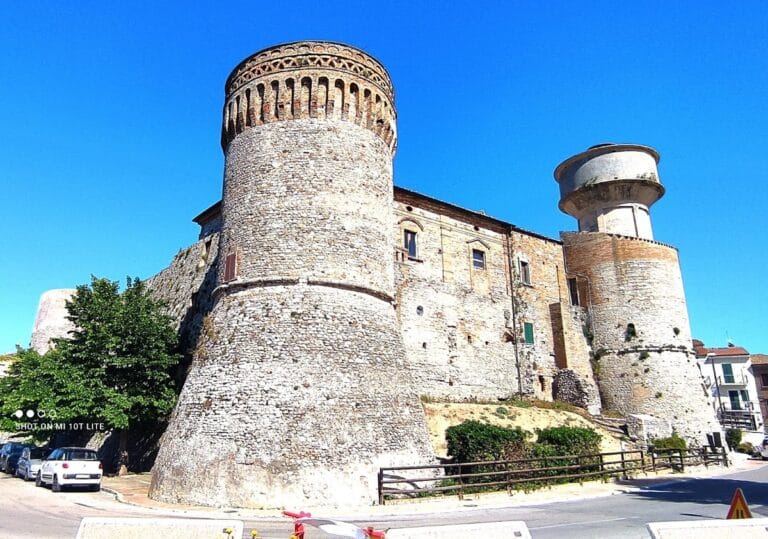
The castle combines a completely brick-built square Norman structure with later mixed masonry. This core is covered by a barrel vault and is enclosed by a square, battered structure that narrows upward in a truncated-pyramidal form. Four projecting corner towers, or small corner rondels, are attached to its base. The complex rises especially high on its northern, seaward side, where its former observation and defensive purpose shaped the construction. A moat extended along the northeastern side, receiving the watercourse formerly called the Rugonio, which is now closed off by modern construction.
Entrance, barbican, and coastal defenses
The original medieval entrance stood on the northeastern side at first-floor level. Brackets for the ropes and hoisting machinery of the drawbridge remain visible there. The entrance connected the Montecastello area with the tower and was associated with a barbican and a sea approach. The former barbican survives as a fragment of wall beneath the embankment that filled the moat, and excavations identified a second barbican tower about two metres below the embankment fill.
Half of a segmental-arched vault belonging to a second sea entrance survives beside the right-hand portal, where the opening for its gate remains visible. A gun embrasure in the lower part of the belvedere tower, at the level of the coastal breakwater, was positioned to cover the western rubble wall. The coastal defenses therefore retain physical evidence of both medieval access arrangements and later firearm use.
Lower and upper rooms
The lower part of the castle stands slightly above the present street level. Its former storage and warehouse area contains four large rectangular rooms arranged around the Norman structure, each covered by a barrel-vaulted roof. A modern staircase links these ground-floor rooms with the first floor, replacing earlier wooden circulation structures.
The upper level combined storage with defense. Its rectangular, barrel-vaulted rooms are known as the Archers’ Corridor and contain numerous loopholes through which archers and crossbowmen could fire downward. The lower rooms also preserve traces of later human use, including sixteenth-century graffiti and eighteenth-century charcoal inscriptions with names, dates, and statements about imprisonment. One surviving phrase reads, “upon entering… I killed.”
Main tower and defensive details
The terrace of the main tower retains stone corbels, originally intended to support projecting wooden defensive structures and platforms from which missiles could be dropped. An upper addition was built in the early modern period. The former machicolation supports later became associated with a crenellated superstructure described as decorative from 1640 onward. The crenellations collapsed through erosion, leaving worn traces on the tower.
The introduction of firearms changed the openings and southern defenses. Some loopholes were converted into arquebus openings, while two opposing southern walls with diamond-point profiles were constructed. The left wall has been consolidated in brick, and the right wall forms part of a private garden. The tower’s south side preserves eroded marks where the collapsed corbels once stood.
Surviving towers and enclosing walls
Four of the seven towers historically present until 1700 remain. The northern tower, Tornola, is severely degraded and has lost its upper section. The belvedere tower remains visible. Another tower is visible halfway because it was incorporated into the convent in the northeastern area; it formerly formed one of the casemates, fortified chambers or positions designed for sheltered defense, of the medieval settlement.
A corresponding structure existed to the northwest, where a square tower and a ruined strip of wall survive. The wall formerly ended in a battered tower shown in an eighteenth-century engraving by Abbot Pacichelli. The enclosing walls are in serious condition. On the western side, much of the rebuilt masonry is considered structurally unstable and historically inconsistent in material. On the eastern side, the walls have been almost entirely replaced by unauthorized houses.
Earthquake damage and surviving traces
The filled six-metre crack in the left facade remains visible, as does the structural imbalance in the middle of the western facade caused by the 1627 earthquake and the uplift of the rocky coast. Together with the eroded marks on the tower’s southern face, these features preserve the effects of earthquake damage, erosion, rebuilding, and changing defensive technology within the surviving fabric of Castello Svevo.
Nearby sites