Burgruine Mitterberg: A Medieval Castle Ruin in Upper Austria


Site at a Glance
- Rating
- 4.8
- Popularity
- Very Low
- Country
- Austria
- Primary era
- Medieval
- Eras represented
- Medieval
- Civilizations
- Duchy of Austria, Habsburg, Holy Roman Empire
- Site type
- Military
- Remains
- Castle
On this page15 sections
History
Burgruine Mitterberg is a medieval castle ruin in Austria, east of Perg in Upper Austria. It developed during the Middle Ages into the largest castle complex in the Mühlviertel and helped secure the Machland, a historical territory in what is now the Lower Mühlviertel, against incursions from Bohemia, Hungary, and Turkish forces.
Early Fortifications and the Mitterberger Lords
The bailiffs and lords of Perg and Machland probably established the first fortifications on the rocky plateau later occupied by the main castle. Rudolf III of Perg, who lived between 1085 and 1135, may have founded them, although this attribution remains uncertain. The castle name appears in 1165 with Wernhardus de Mitterperg, but that witness may have come from another place called Mitterberg in Upper Austria.
Around 1180, Duke Leopold V of Austria probably confiscated Mitterberg from Friedrich II of Perg after Friedrich killed Sintram, the ducal judge of Klosterneuburg, during a dispute. Friedrich later received the castle back as a fief. After his death on 15 July 1191 while taking part in the Crusade of Emperor Frederick Barbarossa, Friedrich’s widow Agnes of Wald and their son Friedrich III of Perg moved away.
Mitterberg subsequently passed to members of the lower Machland nobility, who adopted the name Mitterberger. Documents name Gumpoldus and Marquardus de Mitterberc in 1208, Dietricus and Chunradus de Mitterberch in 1227, and Chunradus and Otto de Mittirberch in 1240. Ulrich III of Mitterberg, who died in 1360, was the last recorded member of the family.
The Kapeller Administration
The Kapeller and Liechtenstein families later held Mitterberg. In 1277, Duke Albert I of Austria granted the lordship as a fief to Ulrich II of Kapellen, who lived from 1250 to 1301. Ulrich became captain of the land above the Enns in 1279 and land judge of the Machland court in 1281. Because the court was based at Mitterberg, it became known as the Kapeller Land Court.
The Kapellers expanded the castle and occupied it themselves. Janns I, also called Hans, of Kapellen built the Chapel of Saint Mary in the main castle in 1351. The abbot of Melk Abbey, the ecclesiastical feudal lord responsible for the parish church of Pergkirchen, authorized a chaplain for the chapel.
Eberhard II of Kapellen, who died in 1406, was the last Kapeller lord of Mitterberg. His daughter Dorothea of Kapellen died in 1426 after marrying Hartneid V of Liechtenstein, who died in 1427. Through this marriage, the castle initially passed to the Liechtenstein family.
Fortress, Court, and Ruin
In 1486, Christoph III of Liechtenstein, a supporter of a noble league opposing Emperor Frederick III, greatly strengthened Mitterberg. The main castle was protected by shell towers, whose interiors were partly open toward the enclosed area, or by artillery rondels, rounded fortifications designed for firearms and to absorb artillery fire. Two large defended outer wards completed the fortress.
Imperial troops led by Gotthard of Starhemberg, governor of the land above the Enns, attacked Mitterberg in 1486 and caused extensive destruction. Whether the fortress was completely captured is uncertain. From 1491, new pro-imperial lords held the site, including Ladislaus Prager, Sigmund Prüschenk, Heinrich Prüschenk, and Anna Prager, Ladislaus’s widow. The Prüschenks, who from 1495 also styled themselves Counts of Hardegg and in the Machland, placed less emphasis on strengthening the fortress. Manorial authority and the administration of the Machland land court remained their main concerns.
The Prüschenks built their own castle at Grein on the Danube between 1491 and 1493. Mitterberg was then managed by castle administrators, including Peter Widmer, Stefan Piber, Wilhelm Frodnacher, Christof Graaber, and Hanns Panhalm, the last recorded administrator there. In 1533, the Prüschenks moved the Machland land court from Mitterberg to Grein, where it became the Greinburg land court alongside several smaller courts. The court had existed since about 1227 in the Machlandviertel, and its seats had included Arbing and Klam before Mitterberg became its administrative center.
In 1564, Andreas von Prag ordered dressed stone, meaning blocks shaped for masonry construction, and other building material to be removed from Mitterberg for his new Pragtal Castle. Further dismantling left the site as a ruin, although buildings in the outer wards probably continued to serve as dwellings for some time. A prospect by Clemens Beuttler from 1664 depicts the complete castle site, while a prospect from 1654 shows a bridge over the castle ditch between the remains of a shield wall and a round tower.
Excavations by the local historian Leopold Mayböck below the main building recovered ceramic fragments and iron objects. The finds are preserved in the Heimathaus-Stadtmuseum Perg. The iron objects are associated with the warlike destruction of the main castle. The privately owned ruin has no monument-protection designation.
Remains
Mitterberg occupies a wooded hilltop at approximately 330 metres above sea level, between Perg Castle and the fortified church complex of Pergkirchen. The Thurnhofbach passes below the castle to the west. It was formerly called the Lembach or Mitterbergbach. The castle area extends about 230 metres from north to south. It was approximately 100 metres wide around the northern Meierhof and outer wards and about 50 metres wide at the southern main castle. Earthworks form most of the surviving remains, while a few walls of dressed stone blocks remain visible and walkable.
Northern Approach and First Outer Ward
Meierhof and Entrance Area
A foremost ditch at the northern end was supplied by a small channel from the Thurnhofbach. It ran uphill toward the entrance gate and probably continued beyond it. The gate itself stood at the northern approach, but its structure has not survived and may have been made of wood. A later access road begins in this area and follows the western edge of the outer wards toward the third sectional ditch.
The northern Meierhof, a manorial farm supporting a castle estate, and the outer court formed a plateau about 100 metres wide. A small defensive rondel beside the Meierhof measured roughly 9 metres in diameter. Its enclosing walls or ramparts are now only weakly visible, and the later access road crosses the area. The Meierhof associated with Mitterberg is identified with the neighboring Braitenaichinger farmstead, now addressed as Lehenbrunn 14 in Perg, outside the castle complex.
Defensive Ditches and Ramparts
The first sectional ditch climbed from the Thurnhofbach. A bridge once crossed it at the point where the later road passes through, but no bridge remains. Along the northeastern side, the ditch continues as a deep and lengthy defensive cut accompanied by an outer rampart. This ditch system remains one of the most substantial earthwork features of the site.
The first outer ward contains pronounced banks and depressions along the eastern edge of its plateau. These earthworks are interpreted as the foundations of buildings, while a circular depression at the center may mark a well. Additional outer-ward areas extend along the western edge toward the Thurnhofbach. A circular depression there may indicate a small tower. The supplementary enclosing walls survive mainly as steep drops in the terrain.
Horseshoe-Shaped Fortification
A prominent horseshoe-shaped rampart dominates the southern part of the first outer ward. Its interior was lined with a stone wall that functioned as a counterscarp, a defensive wall on the outer side of a ditch. The feature had a diameter of approximately 22 metres, and remnants of the wall survive. Two breaks appear in the rampart, with the larger possibly forming an entrance to the fortification or the castle interior. The 1664 prospect shows buildings in this area.
Inside the rampart stood a second horseshoe-shaped defensive wall with an internal diameter of about 6.5 metres and walls approximately 1.5 metres thick. The rampart and inner wall together may represent a later artillery rondel designed for larger guns. Their arrangement closely resembles the artillery rondel known as Sarmingstein III.
Second Outer Ward and Castle Ditches
Second Outer Ward
The second sectional ditch remains clearly visible, although its presumed bridge has disappeared. Beyond it, the second outer ward was smaller, measuring about 50 metres across. In its northern part, earth banks mark the foundation walls of buildings also shown in the 1664 prospect. A circular depression may indicate a cistern.
Round Tower and Shield Wall
A tall round tower occupied the southern part of the second outer ward and particularly protected the main castle. Its surviving foundation masonry has an internal diameter of about 4 metres and an external diameter of roughly 12 metres. Seven fallen cannons were once recorded beside it. The foundation is incomplete, with a break on the northeast side resembling a passage into the interior.
A shield wall, a substantial defensive wall protecting a vulnerable side of a fortification, additionally guarded the main castle. The 1654 and 1664 prospects show this massive wall, but no visible remains survive. Other enclosing walls of the second outer ward survive mainly as steep edges in the ground. The third sectional ditch, or castle ditch, lies between the second outer ward and the main castle. It remains impressive, although its bridge has disappeared. The 1654 prospect places the bridge between a remnant of the shield wall and a remnant of the round tower.
Main Castle
Residential Building and Chapel Area
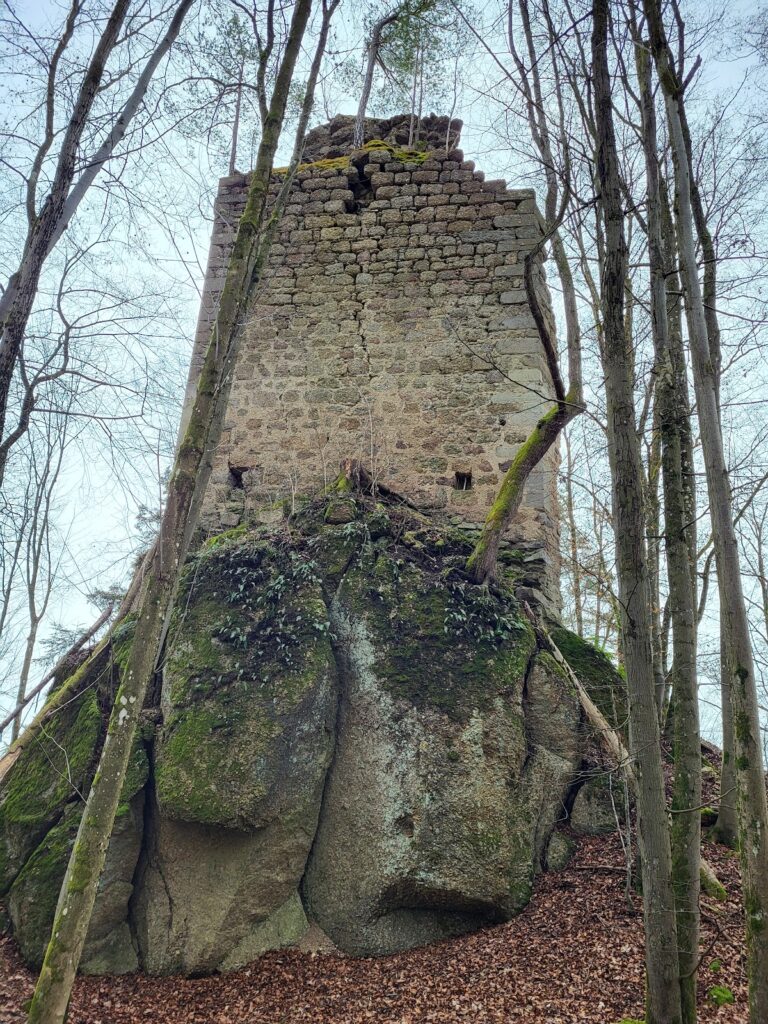
The southern main castle occupied a plateau measuring roughly 50 by 50 metres, approximately 38 metres above the Thurnhofbach. Its principal residential building measured about 15 by 20 metres externally. A substantial vaulted cellar survives nearby, together with a vaulted descent toward the castle chapel and massive wall remains containing a doorway.
Enclosing Wall and Shell Towers
The main castle’s enclosing wall is now recognizable as a steep drop in the terrain. South of the principal building are the foundation walls of three shell towers made from dressed stone blocks. Two were corner towers, while the third was a half-tower. Ceramic fragments and iron objects recovered just below the principal building are preserved in the Heimathaus-Stadtmuseum Perg, and the iron finds relate to the destruction of the main castle during warfare.