Burgh Castle: A Late Roman Coastal Fort in England


Site at a Glance
- Rating
- 4.6
- Popularity
- Low
- Country
- United Kingdom
- Primary era
- Classical
- External website
- Open
- Eras represented
- Classical, Medieval
- Civilizations
- Norman, Roman
- Site type
- Military
- Remains
- Castle
On this page16 sections
History
Burgh Castle is a late Roman coastal fort in the United Kingdom, near Great Yarmouth, built between about AD 260 and 270 on the eastern side of the Waveney estuary. It formed part of the Saxon Shore, a late Roman coastal defence system along parts of southern and eastern Britain. The fort controlled access to important waterways and remained occupied through the end of Roman military rule, before later serving Anglo-Saxon and Norman communities.
Roman foundation and coastal defence
There is no evidence for Roman occupation at Burgh Castle before the mid-third century. Its construction in the late third century belonged to a period when coastal installations were being developed to protect shipping, support naval operations, defend trading centres, and resist seaborne raiders. Their functions probably changed as raids became more frequent.
Burgh Castle and the fort at Caister-on-Sea stood on opposite sides of the large Roman estuary. Together, they probably controlled movement into the Waveney, Yare, and Bure waterways. They may have formed a single defensive system, or Burgh Castle may eventually have replaced Caister in that role.
The fort is often identified with the Roman place called Gariannonum or Gariannum, although the identification is uncertain. The name may instead refer to Caister-on-Sea, or may first have applied to Caister before being associated with both forts. It probably derives from the river-name Gariennus and may have a Celtic meaning connected with a babbling or gurgling river.
Late Roman occupation
The Notitia Dignitatum, a late Roman administrative document listing offices, commands, and military units, places the fort under the Count of the Saxon Shore. This commander was responsible for the coastal district associated with the Saxon Shore forts. The document also associates Burgh with the Equites Stablesiani, late Roman cavalry units. Because the relevant section was compiled in the late fourth or early fifth century, the date and duration of this arrangement remain uncertain.
The coastal forts checked raids for more than half a century. In AD 367, however, Saxons, Picts, and Scots launched a concerted attack on Britain. The coastal commander was killed, and many Saxon Shore forts were subsequently overrun or abandoned. Coins and pottery show that Roman military occupation at Burgh continued into the early fifth century, possibly until AD 407 or 408, when Roman military authority withdrew from Britain.
Anglo-Saxon and Norman reuse
Occupation continued into the Anglo-Saxon period. A cemetery and other evidence point to activity at or near the Roman fort. The monk and historian Bede recorded that around AD 630 Sigeberht, king of the East Angles, gave land within a Roman fortress to Fursa, an Irish Christian missionary, for the foundation of a monastery. Burgh Castle may have been this place, traditionally called Cnobheresburh, although Caister-on-Sea is also possible.
A Christian cemetery inside the fort was used between the seventh and tenth centuries. The early medieval settlement and monastery later declined, leaving the site desolate. After the Norman Conquest, the fort was reused as a motte-and-bailey castle. This form of castle used a fortified earthen mound, usually carrying a timber stronghold, together with an enclosed area for other buildings. At Burgh, a short-lived timber-and-earth fortification occupied the south-west corner and was not replaced by a stone castle. A small pottery industry may also have operated briefly during this period.
Investigation and preservation
Nineteenth-century quarrying for a nearby brickworks damaged the western edge of the fort. The brickworks was served by a wharf just south-west of the site. The first recorded excavations took place in 1850 and 1855. Investigations from 1958 to 1961, including work by the archaeologist Charles Green, revealed internal buildings, a possible early medieval wooden church, and a cemetery. The results were later revised and published by the archaeologist Stephen Johnson.
The Norfolk Archaeological Trust acquired the site in 1995. Its landholding extends beyond the Roman walls and includes buried remains of the associated civilian settlement, preserving them for future investigation. The monument is protected by English Heritage.
Remains
Burgh Castle occupies a raised area beside the southern shore of Breydon Water, on the east bank of the Waveney, above marshland and the former Roman estuary. The western side falls steeply towards the river, while the elevated position overlooked the waterways and surrounding marshes. The fort covered about 2.4 hectares, or 6 acres, within an irregular quadrilateral measuring roughly 205 by 100 metres. Its corners were rounded, and the overall alignment was approximately north-east.
Walls and external defences
Roman walls
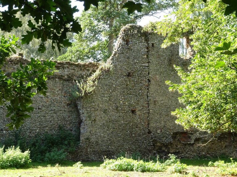
The walls were built mainly from flint, with alternating tile bonding courses. Their mortared flint-rubble core was faced on both sides with cut flint and bands of tile. The walls were about 3.5 metres wide at the base and tapered to approximately 1.5 metres at a surviving height of about 4.5 metres. Some measurements give sections as about 2.02 metres thick, while the eastern wall is more than 3.02 metres wide. On the outer face, three tile courses followed every five or six rows of flint at intervals of about 1.5 to 1.8 metres. A well-preserved stretch of this facing survives on the exterior of the south wall.
The western wall collapsed into the marshes through river erosion. Its foundations have been located, while the north, south, and east walls remain comparatively well preserved, with some sections standing to about 4.6 metres.
Round bastions
Projecting bastions were added late in the construction process. Each had a flat platform with a central circular depression. These features may have anchored a ballista, a Roman artillery weapon, or supported timber watchtowers linked along the wall-top. The bastions may have been added after the walls had reached about 2.1 metres and were bonded into them only several feet above ground level.
Ten regularly spaced external round bastions were probably planned, and six survive. They are positioned on the south wall, at the south-east corner, in two places along the east wall, at the north-east corner, and on the north wall. Erosion has shifted the northern and southern bastions from their original positions, and the southern example has fallen outward. The later bastions were solidly filled with mortar and rubble rather than hollow. Their platforms may have carried heavy artillery, although whether they had tiled roofs or crenellated parapets is uncertain.
Gates and earlier towers
Gates or posterns occupied the centre of each surviving wall. The eastern gate was probably the main entrance and measured about 11 feet 8 inches across; the other two were smaller posterns. Each appears to have been a simple passage without substantial external defensive structures.
The original plan may have included four square towers placed inside the corners. These were apparently abandoned or demolished when the design changed and the round bastions were introduced.
Internal occupation and harbour connections
Buildings within the fort
Archaeological evidence indicates widespread occupation by timber and stone buildings dating mainly from the later first half of the fourth century. Their arrangement followed a pattern inherited from middle-period Roman forts. Buildings in the north-east and south-west sectors were set against the walls and probably dated from the 340s. Socket holes for their supporting timbers remain beside the south wall and at the north-east corner.
Some wall-side buildings were destroyed by fire soon after construction. They may have had low stone walls or may have been made entirely from timber, but their appearance and functions are unknown. Later Roman floor levels show that buildings continued to occupy the interior during the final phase of Roman use.
Civilian settlement and waterways
A large civilian settlement, or vicus, lay outside the fort, probably to the east. A vicus was a settlement associated with a Roman military installation, providing space for housing, trade, crafts, and services. Aerial photography and ground investigations indicate that the settlement was mainly timber-built and extensive, although its structures are now buried.
The Roman harbour probably lay west of the fort in the area now occupied by Breydon Water. Supplies may have arrived by sea, while waterborne communication connected Burgh with the Yare, Venta Icenorum near Caistor by Norwich, and the River Bure route to Brampton. A direct land connection with Caister-on-Sea remains uncertain.
Archaeological finds and cemeteries
Glass hoard and occupation material
An underground hoard of eleven glass vessels was found inside the fort. The group included dishes, bottles, and beakers and was probably deposited in the early fifth century, when the fort was abandoned. The vessels combine Roman and Germanic forms and are of high quality.
Other recovered material includes coins, pottery, tools, knives, animal bones, tiles, and building debris. Roman-Saxon pottery and glass vessels were found within the fort, while a fifth-century cemetery lay outside it.
Norman earthwork
In the south-west corner, the Norman motte was made from an earthen mound enclosed by a ditch cut through the Roman south wall. The breach in the wall caused by the ditch remains visible. The mound was partly removed in 1770 and completely levelled in 1839. The ditch was later filled except at its southern end.
The Norman ditch caused subsidence, leaving part of the Roman wall dangerously out of alignment. The foundations of the affected sections have been stabilised in recent years to prevent further collapse.