Burcht van Voorne: Medieval Stronghold of the Lords of Voorne


Site at a Glance
- Rating
- 4
- Popularity
- Very Low
- Country
- Netherlands
- Primary era
- Medieval
- External website
- Open
- Eras represented
- Medieval
- Civilizations
- Holy Roman Empire
- Site type
- Military
- Remains
- Castle
On this page11 sections
History
Burcht van Voorne is a medieval motte-and-bailey castle in Oostvoorne, Netherlands, built for the Lords of Voorne, the burgraves of Zeeland and prominent nobles in the County of Holland. Its oldest structure, a fortified tower house, dates uncertainly to the second half of the twelfth century or shortly after 1200. The castle occupied an artificial mound that improved observation across the Meuse estuary and the surrounding land, helping defend against enemies approaching by this strategic waterway.
The Lords of Voorne
Hugo van Voorne, mentioned in 1108, is the earliest known Lord of Voorne, while Floris van Voorne, recorded between 1156 and 1174, is the first whose historical existence is considered relatively certain. Dirk I van Voorne, mentioned from 1175 to 1189, and Floris are possible patrons of the oldest tower. The lords probably had a family relationship with the counts of Holland and held authority in Voorne as well as the burgrave’s office in Zeeland. Three appanages, Heenvliet, Zwartewaal, and Putten, were separated from Voorne. Along with the Lords of Putten, the Lords of Voorne were the only lords entitled to summon their inhabitants for military service. They also held a motte castle at Ouddorp on Westvoorn, now part of Goeree-Overflakkee.
Conflict and political change
The castle’s development was probably linked to the Loon War, a succession conflict in the County of Holland between 1203 and 1206. Hugo van Voorne supported Ada, Countess of Holland, and his castle at Poortvliet on Tholen was destroyed during the fighting. Construction at Burcht van Voorne began soon afterward. The tower house may have formed the first major phase, while the mound and later defenses developed as the stronghold took shape.
Machteld van Voorne was the last Lord of Voorne. Count William IV of Holland granted her Voorne as a favor in 1337. After her death in 1371 or 1372, the Count of Holland retained the lordship, although parts of it were granted to possible claimants. The castle is also traditionally associated with Jacqueline, Countess of Hainaut, who is said to have regularly resided at Voorne. In 1434 she married Frank van Borssele, who was also Lord of Voorne. Her use of the complex as a country residence in the early fifteenth century gave the ruin its alternative name, Jacoba Burcht.
Decline and conservation
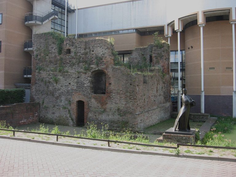
Foundation problems caused the castle to become ruinous by the seventeenth century. Images show that several parts had already begun to lean toward the moat. Cornelis van Alkemade visited the site in 1728 and described it, and Adriaan Kluit later visited while preparing his unpublished work De Landen van Oost-, West- en Zuid-Voorn. Excavations began in March 1934 as part of an employment program. The ruins remained state property until 15 January 2016, when they were transferred to the Nationale Monumentenorganisatie, also known as Monumentenbezit. Burcht van Voorne has been a Rijksmonument, a monument protected under the Netherlands’ national heritage system, since 11 October 1966, under monument number 38897. The surviving remains have since been conserved.
Remains
The motte and tower house
Tower house
The castle’s central mound is approximately 69 metres in diameter. Its base appears to have been a natural dune or sand hill about 7 metres high, raised with a layer of sand mixed with loam. This layer measured about 0.50 metres at the centre and at least 1 metre near the later ringwall. The mound is archaeologically dated to the thirteenth century because no twelfth-century pottery fragment was found in place, while architectural interpretation dates the tower house to shortly after 1200. The tower was founded at the original dune level and the mound was then built up around it.
The square tower house measured 12.60 by 12.60 metres and had walls 2.60 metres thick. Only the lower half of its partly subterranean basement survives. The basement had a vaulted ceiling and was reached from the main floor by a stair in the western wall. Rather than serving chiefly as a normal residence, the tower functioned primarily as a defensive refuge.
The ringwall and entrance defenses
Ringwall
A polygonal ringwall was later constructed around the tower, approximately halfway up the mound. Its diameter varied from about 42 metres at its widest point to 37 metres at its narrowest. The wall was comparatively thin, measuring 0.60 to 0.90 metres, and had inner buttresses at irregular intervals of approximately 1.40 to 4 metres. Four towers and a projecting gatehouse were incorporated into the circuit. The gatehouse measured about 8.4 metres square, while the other towers were considerably smaller. A protected wall-walk ran along the defenses and had an average width of 3 metres.
The outer bailey
Residential and service buildings
The outer bailey occupied level ground in front of the mound and contained housing, manorial buildings, the great hall, a chapel, stables, and other associated structures. These buildings have not been archaeologically excavated, but their arrangement is known from maintenance accounts dating from the fourteenth to the sixteenth centuries. The inhabited area lay in a horseshoe-shaped arrangement against the southwest side of the moat, with a chapel standing there from 1277 onward.
An image made by Cornelis van Alkemade around 1700 depicts the outer bailey extending around the entire mound rather than only in front of it. The possibility that the castle occupied an earlier Viking ring-fortress-type earthen enclosure remains speculative because that area has not been archaeologically investigated. Today, the former outer-bailey area is meadowland, while the restored ruins rise to approximately 4 metres above their foundations.