Arbeia, South Shields Roman Fort: A Roman Frontier Supply Base


Site at a Glance
- Rating
- 4.6
- Popularity
- Low
- Country
- United Kingdom
- Primary era
- Classical
- External website
- Open
- Eras represented
- Classical
- Civilizations
- Roman
- Site type
- Military
- Remains
- Fort
On this page21 sections
History
Arbeia, South Shields Roman Fort, in the United Kingdom, was a Roman fort and military supply base developed from the early second century in Roman military architectural traditions. Overlooking the mouth of the River Tyne, it guarded the river port and the sea route linking Hadrian’s Wall with southern Britain. Although the fort stood about six kilometres east of the Wall’s eastern end at Wallsend, it formed an essential part of the wider frontier system.
Before and during the early Roman occupation
Human activity at South Shields began long before the Roman period. Mesolithic activity dates to about 8300 BC, followed by Neolithic farming between about 3500 and 1800 BC. An Iron Age farmstead occupied the area around 300 BC, while earlier settlement is broadly dated to about 3000–4000 BC.
By the early second century, a timber fort stood somewhere in the South Shields area. Its associated civilian settlement lay beneath the later stone fort, although the exact position of the timber installation remains uncertain. It may have occupied higher ground farther south. The early fort was established before the construction of Hadrian’s Wall, the Roman frontier barrier across northern Britain, which began in AD 122. The fort was probably repaired or rebuilt during the Wall’s construction, when a second occupation phase included a training ground.
When the Romans established the Antonine Wall in Scotland around AD 142, the South Shields garrison probably declined in importance and may have been reduced or withdrawn. Hadrian’s Wall was reoccupied around AD 158, and a stone fort was built at South Shields during the 160s.
Garrison and supply base
The installation began as a cavalry and cohort fort. Its first recorded garrison was probably the Ala I Pannoniorum Sabiniana, a Pannonian auxiliary cavalry regiment. It was later replaced by the Ala I Hispanorum Asturum, a cavalry unit associated with the Astures of north-western Spain. The Sixth Legion, Legio VI Victrix Pia Fidelis, probably supplied a construction detachment and specialist builders, but it was unlikely to have been the permanent garrison.
During the late second century, the garrison appears to have been reduced. In the early third century, the cavalry transferred to campaigns in northern Britain and an infantry unit, Cohors V Gallorum, took its place. This change accompanied the fort’s transformation into a major supply base.
Between AD 205 and 207, during the reign of Emperor Septimius Severus, most earlier buildings were demolished and replaced by stone granaries. The fort expanded southward, with a northern storage area and a southern garrison area. Its supply role supported Septimius Severus’s campaigns in Scotland between AD 208 and 211. Lead baggage sealings connected with the imperial household were found at South Shields, suggesting that the emperor and members of his family may have stayed at the fort. Arbeia may also have served as the emperor’s headquarters, although that interpretation remains uncertain.
Septimius Severus died at York in AD 211, after which Roman forces withdrew from Scotland. Between AD 222 and 235, the garrison accommodation was rebuilt, and the supply base continued to provision Hadrian’s Wall and forts in its hinterland. Grain arrived by sea from southern England and possibly from the Continent because local agriculture could not supply the military communities.
Late Roman transformation
In the late third or early fourth century, the fort was attacked and burned. Rebuilding altered its internal functions. Part of the supply complex became accommodation, a new headquarters was erected, and a large commanding officer’s house was built in the southeastern corner. This was probably the final major rebuilding phase and may have accompanied the arrival of the Numerus Barcariorum Tigrisiensium, a specialized unit of boatmen associated with the River Tigris and the eastern Roman Empire.
The unit remained at the fort until the end of Roman rule in Britain. Minor fourth-century alterations, including the abandonment of heating systems and at least one dining room in the commanding officer’s house, point to declining living standards. The name Arbeia appears only in the Notitia Dignitatum, a late Roman administrative register listing military commands and officials. It became widely used for the fort in 1953 after research by Ian Richmond. The name has traditionally been interpreted as “the place of the Arabs” or “the fort of the Arab troops,” referring to the eastern unit, but that explanation is speculative. Another proposed derivation links it with rapa, the Latin word for a wild turnip. The fort may earlier have been called Lugudunum, although this too is uncertain.
After Roman rule
Roman rule in Britain ended by the early fifth century, but occupation at the fort continued. A granary was demolished, gravel was quarried from a former street, and a pit containing the bones of two youths with weapon cuts to their skulls reflects the unsettled conditions of the period.
The west gate fell out of use in the early fifth century, when a large ditch was dug in front of it. The partly ruined gate was later restored, with one arched carriageway replaced by a timber entrance. During the fifth century, the fort probably functioned as a stronghold controlling the surrounding countryside.
Occupation continued through the post-Roman and Anglo-Saxon periods. The site may have become associated with the Northumbrian royal house and was traditionally identified as the birthplace of Oswin, King of Deira, who was killed in AD 651. Objects from the sixth to the ninth centuries show continued use. The fort may finally have been deserted in the ninth century, possibly because of Viking raids.
Excavation and preservation
By the eleventh or twelfth century, the land belonged to Durham Cathedral and remained in its possession until 1875. It was open farmland until housing development threatened the remains in the late nineteenth century. Large-scale excavation began in 1875 after antiquarians sought public support to investigate the fort before construction destroyed it. At the time, it was only the second large-scale excavation of a fort in northern Britain. Public interest led the council to preserve part of the site as a Roman Remains Park, while house building around the fort revealed the tombstones of Regina and Victor.
Ian Richmond’s excavations in 1949–50 established the broad history of the fort. A museum opened in 1953, and the South Shields Archaeological and Historical Society later undertook important excavations, including work directed by John Gillam in 1966–67. Housing built over the fort was demolished during the 1960s and 1970s, allowing the area to become an archaeological park. From 1975, Tyne and Wear Museums continued excavation, reorganized the displays, and reconstructed selected parts of the fort. North East Museums now manages the site on behalf of South Tyneside Council. Arbeia forms part of the UNESCO World Heritage Site associated with Hadrian’s Wall.
Remains
Arbeia was laid out as a multi-phase Roman fort in a rectangular playing-card plan with rounded corners. Its walls had internal towers and were backed by an earth rampart that also provided a walkway. The earlier stone fort covered about 1.67 hectares and measured approximately 110 by 180 metres. Between AD 205 and 207, the southern wall was demolished and rebuilt farther south, enlarging the enclosed area to about 2.1 hectares. Four gates, principal roads, defensive ditches, storage buildings, administrative structures, barracks, and later domestic buildings occupied the interior.
Defenses and internal layout
Gates and roads
Each of the four gates was protected by two flanking towers. A double V-shaped ditch added another defensive obstacle outside the walls. The principal roads, the via praetoria and via decumana, divided the fort into four areas. The section of the via praetoria running from the south gate to the headquarters was paved and bordered by colonnades. Later paving reused stone from demolished buildings, including the earlier headquarters.
West gate
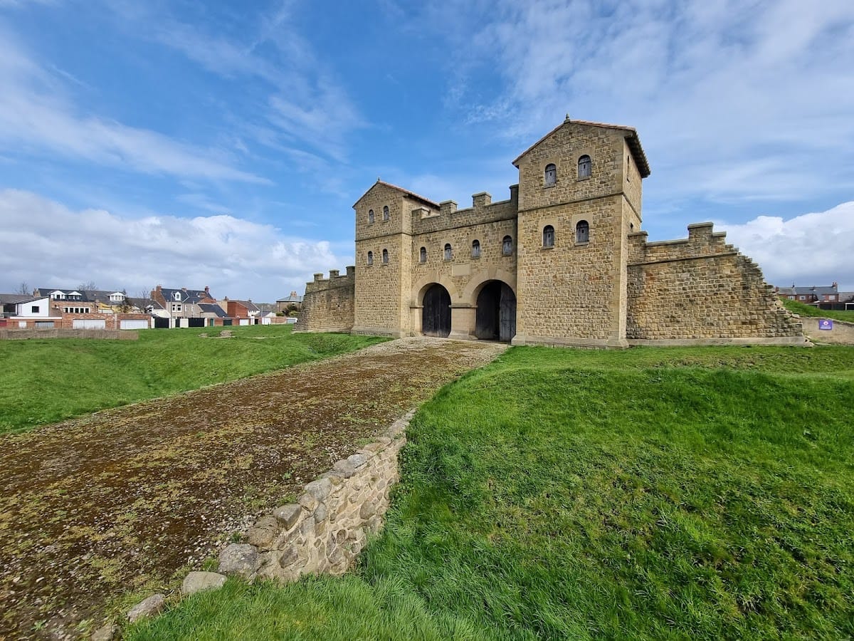
The reconstructed west gate represents its appearance around AD 161–180. Two slightly projecting, multi-storey towers with tile roofs flank its two carriageways. A guardhouse stood above the entrances, while a crenellated walkway ran along the top. The reconstruction used surviving foundations, architectural fragments such as an arch voussoir, comparisons with other Roman gates, contemporary representations, and analysis of the gate’s functions. The structure contains museum displays and an observation level.
Supply buildings
Granaries
The early fort had two stone granaries, a paired arrangement known as a double horreum, or Roman storehouse. Between AD 205 and 207, thirteen more stone granaries were built in three parallel rows across the front and central parts of the fort. Two were inserted into the abandoned earlier headquarters. A further eight granaries were added between AD 222 and 235.
The granaries probably held grain mainly in sacks. Raised floors allowed air to circulate beneath the stores through openings in their supporting walls. Parallel low walls supported the floors, with interruptions that improved ventilation. Each granary had ten external buttresses along its long sides and two along each short side to withstand roof pressure. Broad foundations created small loading platforms, while traces of post or column bases probably supported projecting awnings. Together, the granaries could store grain for approximately 40,000 people, and their substantial foundations are among the best-preserved Roman remains at South Shields.
Later supply-area buildings
The enlarged fort was divided by an internal wall into northern and southern areas. The northern section contained the principal stores, while the southern section housed the garrison. The dividing wall was later demolished during the Scottish campaigns. After the late third- or early fourth-century fire, the eight southern granaries were converted into barracks, and two further barracks were built to the south. The fort was again arranged with storage in the north and accommodation in the south, where buildings stood around two streets crossing at right angles.
Headquarters and military accommodation
Headquarters buildings
The original headquarters, or principia, measured about 20 by 25 metres. This was the fort’s administrative, ceremonial, and religious centre. Its southern entrance opened into a walled courtyard with porticoes on the east and west. Beyond the courtyard stood a west–east-oriented cross hall, probably a basilica, about nine metres high. Windows beneath the roof ridge lit the hall, which may have accommodated assemblies and exercises in winter or bad weather.
A square standards shrine, or aedes, projected slightly to the northwest from the rear of the basilica. Two adjoining rooms may have served as offices or armouries. In the early third century, the original headquarters was demolished and partly replaced by two granaries. A replacement headquarters was built in the southern extension, but after the later fire the headquarters returned to its original location. Two headquarters buildings are among the excavated and reconstructed remains.
Barracks and latrine
Four barrack blocks were built in the southern extension between AD 205 and 207. They comprised two paired barracks and two single blocks, each approximately 12 by 40 metres. Two cavalry barracks have also been excavated, although they are not visible on the site. In the early third century, a communal latrine was inserted into the earth rampart of the eastern wall. It resembled the latrine at Housesteads and discharged through a channel supplied continuously with fresh water.
Commanding officer’s house
Praetorium
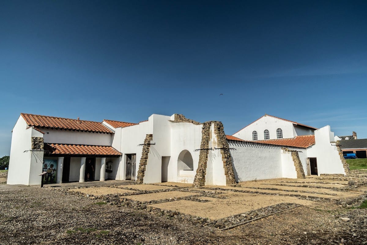
The late Roman praetorium, the residence of a senior commander, occupied the southeastern corner of the fort. This luxurious house had a peristyle plan, meaning that rooms were arranged around a colonnaded courtyard. Its unusual position at the edge of the fort and its scale make it one of the best-known commanding officers’ residences in Roman Britain. It was reconstructed in 2000 on its original foundations.
The western entrance led into a decorated hall or atrium. A small corner room probably served as a porter’s office, while another may have been a minor reception office. A stone-lined shaft in the atrium may have stored valuables. The central courtyard contained a fountain or other water feature. Private rooms occupied one side of the house, including rooms heated by a central praefurnium, the furnace that supplied hot air to an underfloor heating system, or hypocaust.
The opposite side contained a large unheated dining room and a smaller dining room with a hypocaust, probably used in winter. A small private bath suite stood near the entrance. Other rooms probably served as a kitchen and storerooms, with direct access to the internal rampart road. Another room held a storeroom, a hypocaust furnace, and a latrine. An adjoining roughly paved room with a drain may have been a cattle stall.
Fresco decoration, reconstructed wall paintings, the courtyard water feature, and the private heated bath suite show the house’s elaborate character. Its plan and decoration resemble elite Mediterranean houses of the third and fourth centuries. The reconstructed courtyard house and portions of a reconstructed barrack stand on their original foundations.
Water supply and archaeological finds
Aqueduct
An aqueduct supplied water to the fort. An inscription states that Emperor Severus Alexander introduced the water for the soldiers of Cohors V Gallorum under the supervision of the provincial governor Marius Valerianus around AD 222. Other excavated remains include a water-settling tank, a tile kiln, two angle towers, a building of unknown function, and two gateways.
Objects and inscriptions
Large transport amphorae, probably imported from Campania, show that Mediterranean wine reached the fort into the third century. Animal remains include cattle, sheep, goats, pigs, red deer, wild boar, elk, oysters, mussels, limpets or periwinkles, and edible land snails.
Regina’s tombstone commemorates a woman from the Catuvellauni who had been enslaved and later became the freedwoman and wife of Barates, a merchant from Palmyra. She died aged 30 in the second half of the second century. Victor’s tombstone commemorates a 20-year-old freedman from North Africa who served in the Ala I Asturum. The inscription describes him as being of Moorish origin and records the care with which his former owner, Numerianus, arranged his burial.
The museum preserves an altar dedicated to a previously unknown deity and a tablet from which the name of Emperor Severus Alexander was deliberately erased. This was an example of damnatio memoriae, the deliberate removal of a condemned person’s name and memory from public inscriptions. A fragment of Roman chain armour was recovered from a well. Two interpretive galleries, “Set in Stone” and “Amazing Finds,” address the fort’s buildings, religious practices, burials, objects, and evidence for daily life.