Aquis Segeste: A Roman Sanctuary and Settlement in France
Site at a Glance
- Popularity
- High
- Country
- France
- Primary era
- Classical
- Eras represented
- Classical, Medieval
- Civilizations
- Roman
- Site type
- City
On this page28 sections
History
Aquis Segeste was a Roman sanctuary settlement at Sceaux-du-Gâtinais in France, founded in the first century AD. Its growth centred on worship of Segeta, a Gallic goddess associated with healing waters, and a spring believed to have therapeutic properties. The settlement lay in the territory of the Senones, near an uncertain western boundary with the Carnutes and, before the end of the fourth century, the Roman district known as the civitas Aurelianorum. It belonged to the province of Gallia Lugdunensis. The Peutinger Table, a medieval copy of an ancient Roman itinerary map, names Aquis Segeste among 52 Roman settlements associated with water.
Before and during the settlement’s foundation
Stone tools and flint flakes may point to Neolithic activity, although their original find locations are uncertain. Pottery indicates occupation in at least part of the site during the protohistoric period, when written evidence may come from neighboring societies. A settled community may have developed during the La Tène period, a late Iron Age cultural period in Europe, perhaps alongside an early cult of healing waters. A recovered brooch and miniature stone monument may also predate Roman occupation.
Growth and prosperity under Roman rule
The settlement expanded under the Flavian emperors, the dynasty that ruled Rome from AD 69 to 96, especially during the reign of Domitian (AD 81–96). This phase saw the first buildings and the initial development of the spring. Aquis Segeste reached its height in the second century, when the sanctuary and water system were substantially renewed and the baths and monumental spring building were developed. Prosperity continued until the end of Marcus Aurelius’s reign in AD 180, though the course of events differed between residential districts and public buildings.
A fire damaged houses in the northern area during the first half of the second century, after which that district was rebuilt with a substantially changed layout. A separate severe fire struck the therapeutic baths and the sanctuary’s southern portico in the late second or early third century. Residential rebuilding was more modest: some blocks were abandoned, and houses became smaller and simpler. Parts of the portico and gallery were reconstructed on a less imposing scale, while some rooms and shops were put to storage use, reflecting reduced activity.
Decline and abandonment
During the third-century crisis, activity contracted further. Finds became relatively sparse, and the sanctuary received less maintenance. There was a brief revival in the Constantinian period, when builders reused materials from ruined or demolished structures. In the fourth century, rising water levels destroyed or inundated the sanctuary. Poorly maintained drainage may have contributed, as may declining interest in the pagan sanctuary as Christianity spread. The settlement continued for a time but was abandoned by the end of the century. The latest coins placed as offerings in the spring building date to the late fourth century.
In the fifth or sixth century, bundles of wood permanently blocked the channel that had supplied the spring building. Cemeteries from the Merovingian period, when the Frankish dynasty ruled much of Gaul, indicate that occupation shifted from the Préau site to the settlement at the modern village. An earlier community had existed near the ancient crossing of the Fusain. The ancient settlement’s origin was later forgotten, although its name remained on the Peutinger Table.
Rediscovery and archaeological work
For centuries, people quarried the ruins for building stone. In 1836, engineer Jean-Baptiste Jollois noted the recovery of stone; in 1854, Étienne-Théodore Cosson observed that reused antiquities could be found in local houses. Material from the settlement also went into the former Saint-Saturnin church at Sceaux, the Passard bridge over the Fusain and the park wall at Courtempierre castle. The lack of later building over the ancient settlement helped preserve its remains.
Jollois rediscovered the site in the early nineteenth century and made a plan based on visible remains and surface finds, but misidentified it as Vellaunodunum, a Senonian fortified settlement mentioned by Julius Caesar. From 1868 to 1874, Cosson identified a theatre where Jollois had proposed an amphitheatre, recognized that large basins belonged to the sanctuary, and traced the aqueduct. In 1917, Loiret archivist Jacques Soyer connected the site with Aquis Segeste on the Peutinger Table.
Test excavations took place from 1952 to 1955. The sanctuary’s western entrance threshold was uncovered by chance in 1963, prompting Michel Roncin to excavate its southern part; a team led by Roncin continued work from 1966 to 1976. The discovery of a dedication to Segeta in 1972–73 confirmed the identification as Aquis Segeste and disproved the earlier identification as Vellaunodunum. Flooding halted excavation from 1976 to 1985, after drought brought groundwater back to the surface. A permanent pumping station was established between 1985 and 1988 to lower the water table.
In 1986, two parcels totalling about one hectare, including visible remains, received partial protection as a historic monument. Work over the following six years focused on the spring sanctuary and led to the discovery of therapeutic baths beside its southern side. Aerial photographs, especially those taken in the mid-1970s by Daniel Jalmain, revealed further structures. Restoration and site work from 2000 to 2005 included surveys of the southern baths, and excavation resumed in 2005. Ground-penetrating radar and preventive excavation in the northern area from the mid-2010s to 2023 further investigated the settlement ahead of a proposed museum.
Remains
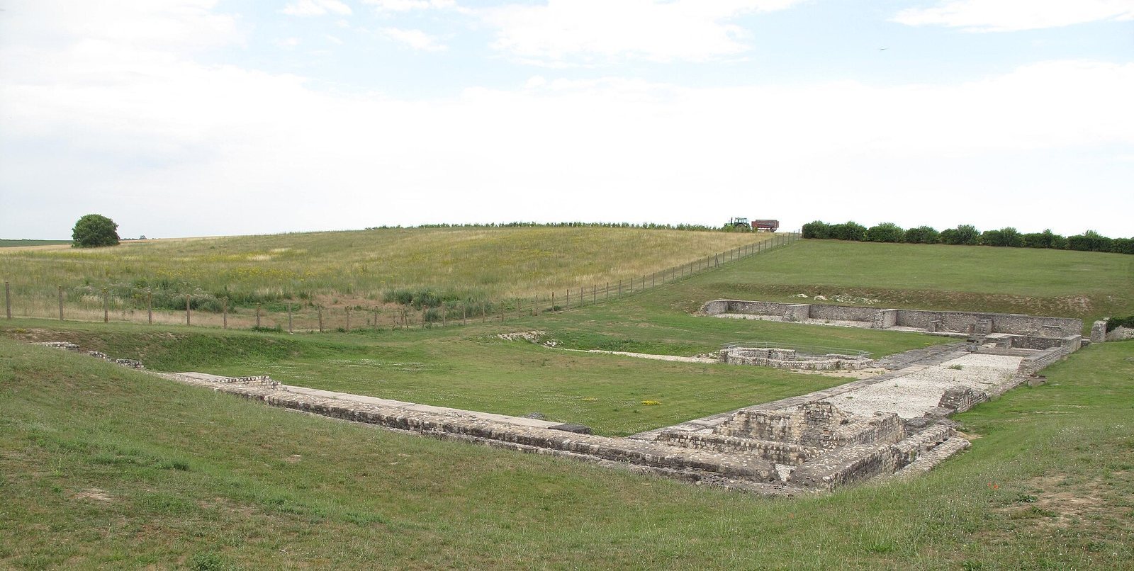
Aquis Segeste occupied a dry valley running north to south toward the Fusain valley. Its sanctuary and baths lay in the valley bottom, the theatre stood against the steep eastern slope, and residential areas spread across the gentler western plateau. The settlement covered about 25 hectares, of which roughly 15 hectares were built up. Local limestone, including stone from Souppes and Château-Landon, was used in blocks and slabs that suited the local geology.
Setting and layout
Valley and surrounding terrain
The temple area lies at about 84 metres above sea level, while the spring building and presumed spring are just below 80 metres. The plateaus on either side rise to about 92.5 metres. Beneath the valley’s recent river deposits are Fontainebleau sands and sandstone, overlain by 12–15 metres of Gâtinais limestone. The nearby Fusain flows toward the Loing, an important ancient north–south waterway.
Roads and precincts
A north–south road, just over 700 metres long, ran from the Roman road south of the settlement and helped organize its plan. That southern road, between Sens and Orléans, passed about 500 metres from the site. Other routes may have linked Sceaux-du-Gâtinais with Château-Landon to the north and Montargis to the south; another stretch formed part of the Paris–Autun route.
On the eastern side of the main road, a sequence of courts included a poorly understood southern court and a sacred enclosure about 200 metres long and 75 metres wide, covering roughly nine hectares. It contained the two bath complexes and other buildings whose purposes are uncertain. The spring sanctuary extended north from this enclosure and measured just under 100 metres in length, with a similar width.
Sanctuary and spring
Enclosure and courtyard
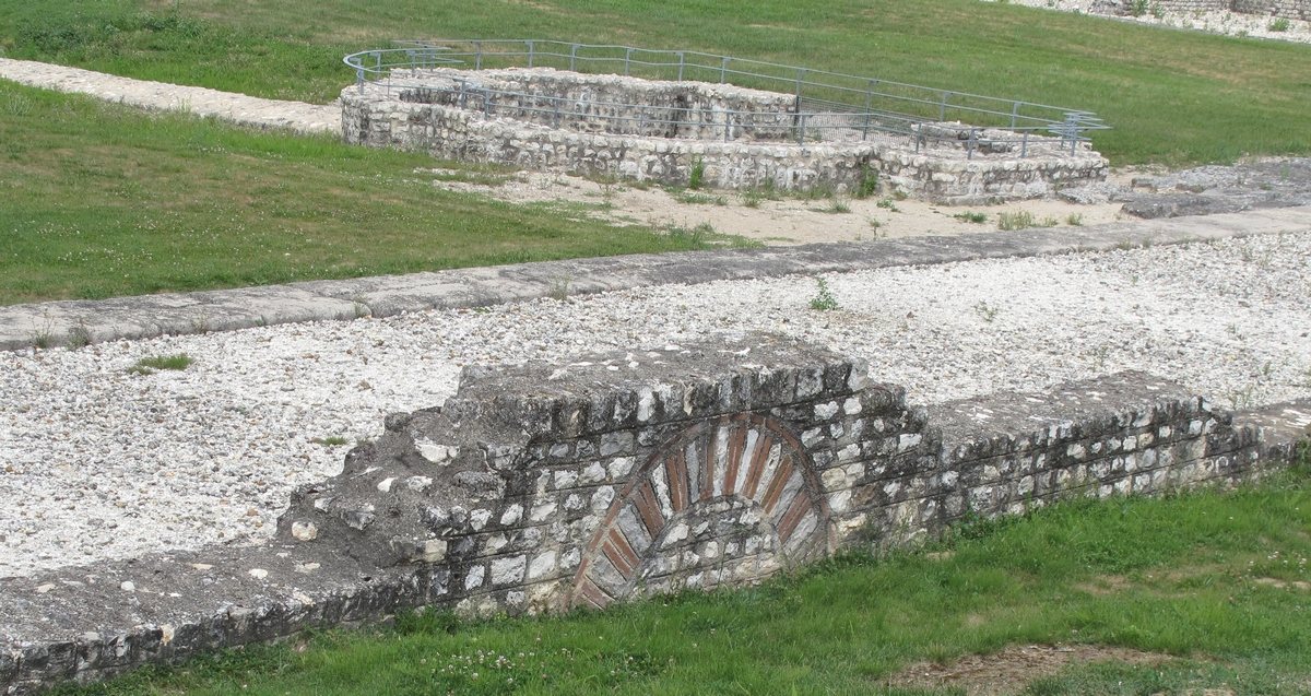
The sanctuary’s enclosure surrounded an open court about 75 by 100 metres. A roofed gallery supported by columns ran around it, with Corinthian or composite capitals. Perforated floor slabs mark the column positions. The monumental southern face projected outward at both ends and had two entrances, each with a threshold about five metres wide. Fixing points in the threshold slabs indicate that the entrances held wooden double doors. The facade also included a decorative arch, built from alternating stone and brick.
Drainage channels ran both outside and inside the galleries. A drain lay along the exterior, while a covered channel lined with slabs carried rainwater through the gallery. The courtyard may have had paving, most of which was removed, or a compacted limestone surface. The walls combined small local limestone blocks and architectural terracotta around a Roman-concrete core. Floors included limestone or terracotta slabs and concrete. Marble, black-and-white mosaic and coloured plaster decorated the sanctuary; surviving plaster fragments suggest possible foliage and panel borders.
Rooms around the galleries
The partly excavated east and west return walls are about 0.75 metres thick. Rooms in the gallery wings were regularly sized, roughly eight by 5.5 metres, and some had partitions or concrete floors. Their functions are uncertain, but they may have served pilgrims as workshops, shops or treatment rooms. Finds point to a maker of votive offerings in one western room and bone-working in another; evidence from a third suggests possible treatment of eye conditions.
Oyster shells may relate to food sales or mother-of-pearl working, and one room contained a central hearth. Animal and poultry bones are consistent with food-related trades. Bronze-working has been proposed for one of two shops beside the room associated with eye treatment, though that interpretation remains disputed. Fluted columns of white limestone, and more rarely marble, carried Corinthian or composite capitals. Tiled roofs rested on wooden frames, and timber was also used to tie the walls together.
Spring and monumental water building
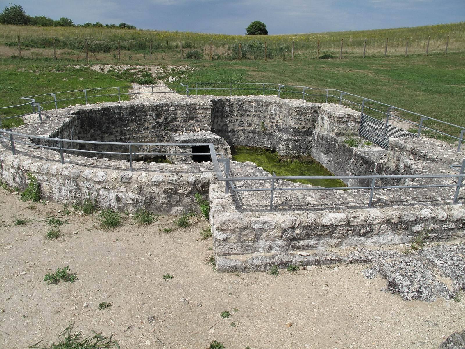
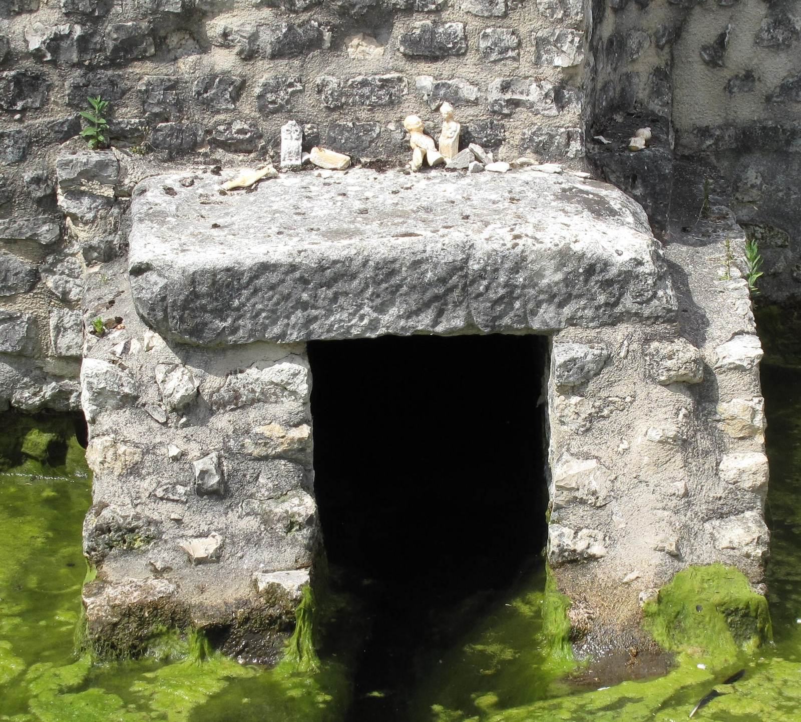
The spring probably lay near the sanctuary’s centre. Its first known installation, likely built in the second half of the first century, was a rectangular basin about 2.5 by 1.2 metres, supplied by a wooden channel and incorporated into a larger masonry structure. In the second century, a monumental spring building measuring about 7.8 by 8.9 metres was erected at the same location. This was the first ancient building of its lobed kind identified in France.
The building had a rectangular plan, a large semicircular recess on its western side and smaller lobes to the north and south. A paved threshold opened to the west. The basin floor was cut into bedrock and covered with compacted clay, and the walls were masonry. The water, which contained iron, was channelled about 30 metres south to the building beside the sanctuary’s southern gallery, then across the southern enclosure to the therapeutic baths. It probably continued toward the Fusain after joining rainwater from the sanctuary.
Offerings and dedication
Pilgrims left offerings in and around the spring building. Some objects suggest petitions concerning fertility, infertility or conditions after childbirth, including a laughing child’s head or small bust and a female figure emerging from water. Metal offerings may represent body parts in need of treatment, such as eyes or genitals; others could express gratitude or a prayer.
Fragments of a circular pink-marble plaque were recovered in 1972–73 from debris that filled the disused building. Almost entirely reconstructed, the plaque is 0.64 metres in diameter, weighs 24.5 kilograms and dates to the second century. Notches suggest it had first been fixed into a wall, possibly for another purpose, before being reused as a dedication to Segeta Augusta. The inscription says that Titus Marius Priscinus willingly fulfilled his vow and that his daughter, Maria Sacra, arranged for its completion. Their names indicate a fully Romanized family.
Baths and water management
Therapeutic baths
One bath complex adjoined the sanctuary’s southern face and received water directly from the spring building. Its first phase, in the third quarter of the first century, included a cold-water basin supplied by wooden pipes. If nearby structures of uncertain purpose belonged to the complex, it may have covered nearly 300 square metres. Reorganized and enlarged in the first half of the second century, it gained a hot room with an underfloor heating system, a connecting corridor and an adjoining cold room. Other rooms remain little explored, so their features and functions are uncertain. Offerings found in the baths point to their use by pilgrims seeking healing.
Public baths and supply
A larger public bath complex stood about 300 metres south of the therapeutic baths, still within the sacred enclosure. It appears to have had its own water supply. Heated rooms, mosaic fragments and pipes confirm its use as a bath complex. An aqueduct nearly 25 kilometres long carried water from springs beside the Bezonde, between Nesploy and Quiers-sur-Bezonde, to these public baths. Its final approach has not been traced; it may have reached the settlement from the north after curving around it to the east.
Drainage
The sanctuary’s galleries had a collector for rainwater and wastewater, probably discharging into the Fusain south of the site. The western residential plateau appears to have had a separate water network. These systems served areas with different water needs, from the spring sanctuary and its healing baths to the public baths and residential quarter.
Theatre and proposed features
Theatre
The theatre was built against the eastern slope and faced west. It measured about 104–115 metres across and may have held 13,000–15,000 spectators. Aerial photographs show the curve of its seating area, while construction debris marks its location at ground level. The outer wall had external supports and a second wall inside it. Fragments of tiles and charred wood suggest that an upper-level portico may have stood above the structure.
Four entrance passages led into the seating, which was divided into upper and lower tiers by a semicircular wall. A further wall separated the seats from the central space in front of the stage. A small opening in this wall led to a square chamber beneath the seats, which archaeologist Albert Grenier interpreted as a tomb. The stage wall has also been located. The west-facing orientation differed from the recommendation of Roman architect Vitruvius and exposed spectators to strong sunlight and glare during hot parts of the day. If the stage structures were not too tall, seated spectators may have been able to see the temple toward which the theatre appears to have been oriented.
Possible amphitheatre and burial area
Unusual ground relief south-west of the sanctuary, at or beyond the built-up area, may mark an amphitheatre, though this interpretation remains tentative. A burial ground on the eastern valley slope, opposite the baths, has also been proposed but is unconfirmed.
Residential districts and temples
Northern residential district
In the north-west, houses followed a right-angled street grid. Survey and excavation identified blocks about 80 by 40 metres and a north–south main street bordered for part of its length by a portico or paved surface. An east–west cross street may have led toward the sanctuary’s northern area. Both roads were repaired repeatedly and remained in use for centuries. The modern Chemin de la Ruelle appears to lie over part of the ancient north–south street beside the sanctuary.
Buildings generally followed the street plan and were probably houses, often with cellars, a building facing the street and open ground behind. Some had decorated and painted masonry walls; others used earth and timber. Many houses were rearranged more than once through the third century, and their remains lie near the surface. After the settlement was abandoned, building materials were selectively removed.
Western residential district and plaza
West of the main north–south road, a passage comparable to an east–west street separated an unidentified built area from a residential district of roughly 12 hectares. Its rectangular street grid enclosed a plaza about 50 metres wide and 100 metres long, surrounded by a colonnaded gallery. The layout and surviving remains indicate a Roman-style residential quarter.
Northern temples
Ground-penetrating radar in 2023 detected at least two successive temples at shallow depth in the northern part of the settlement. The better understood building was a Gallo-Roman temple, with a central shrine surrounded by a gallery, about 20 metres across. It stood midway along the northern boundary of the sacred enclosure, which formed a semicircular recess on either side. The temple may predate the sanctuary’s monumental development and stood a few metres higher. Its precise form and the deity worshipped there remain uncertain.
A half-bust of Apollo or Mercury was found near the spring building, but it does not identify the northern temple’s deity. A nearby bronze rooster may support an association with Mercury. The temple’s position lay near the meeting point of the sanctuary’s north–south axis and the theatre’s east–west axis.
Other archaeological finds
Figurines and small objects
Finds include dozens of white terracotta figurines from the Allier, several showing Venus Anadyomene, the goddess rising from the sea. A rough limestone miniature monument, possibly from the La Tène period, has a male face beneath a pitched roof. Bronze statuettes, mainly shaped as animals, were probably offerings; one bronze goat is 1.5 centimetres long.
Pottery, coins and glass
Pottery includes local everyday wares that sometimes imitate forms known elsewhere. Most first-century fine tableware with a red surface coating came from workshops in southern Gaul, while Lezoux supplied much of the second-century material. Later Roman pottery includes products from the Argonne and the Jaulges–Villiers–Vineux workshops. Scattered pieces from a white limestone and black Autun-schist mosaic date to the late third or early fourth century.
Coins of identifiable origin, mainly offerings from the spring building, came from mints at Arles, Lyon, Trier, Rome and Sisak, and possibly Thessaloniki. They range in date from the reign of Augustus to the late fourth century. Third-century coins are limited to issues of Gallic rulers from the century’s third quarter, including Tetricus I. Weights range from tiny coins of 1.5 grams to sestertii, a Roman coin denomination, weighing 24 grams. Glass finds include windowpanes, vessels such as vases and bottles, and jewellery including bracelets and beads.