Ain Dara: An Ancient Settlement and Temple in Syria


Site at a Glance
- Rating
- 4.3
- Popularity
- Very Low
- Country
- Syria
- Primary era
- Iron Age
- Eras represented
- Stone Age, Bronze Age, Iron Age, Classical, Medieval
- Civilizations
- Achaemenid, Byzantine, Hittite, Seleucid
- Site type
- City
On this page13 sections
History
Ain Dara is an archaeological settlement in Syria, in the Afrin Valley near the Syrian-Turkish border, whose main temple was built and enlarged between about 1300 and 740 BC. The site occupied a strategic position above routes connecting Mesopotamia, Anatolia, the Levant, and the Mediterranean. Its settlement mound consisted of an elevated acropolis, the upper or fortified part of an ancient town, and a lower town that eventually covered approximately 24 to 25 hectares.
Early Settlement and Hittite Rule
People first inhabited Ain Dara during the Chalcolithic period, the later Stone Age phase when copper use emerged alongside stone tools, in the fourth millennium BC. Activity continued through the Late Bronze Age, when the region came under Hittite control after the expansion of Suppiluliuma I around 1350 BC. The Hittite Empire, a major Bronze Age state centered in Anatolia, governed parts of northern Syria until its collapse around 1190 BC. A viceroy, or governor acting for the ruler, based at Aleppo probably controlled the Afrin Valley, while another governed from Carchemish.
The Iron Age Settlement
During the Iron Age, Ain Dara formed part of a politically and culturally connected northern Syrian region. Its varied pottery included Cypriot and Aegean wares comparable to ceramics from Philistine cities in southern Canaan. These finds have been used to suggest connections with the Sea Peoples after the collapse of the Late Bronze Age kingdoms. The lower town flourished especially during Iron Age II, a later phase of the Iron Age in the Levant and northern Syria, when its population has been estimated at roughly 4,000 to 6,000 people.
The lower town was probably fortified near the end of the second millennium BC with defensive walls, towers, and four gates. Ain Dara’s location and scale have led some scholars to identify it as the capital of the Aramean-Luwian kingdom of Pattina, also known as Unqi or Palistin. Tell Tayinat remains the more widely favored identification of that kingdom’s capital. Assyrian forces conquered the kingdom in 738 BC. The city may then have been abandoned before settlement was re-established on the acropolis during the Hellenistic period.
Later Occupation and Destruction
The Hellenistic settlement was fortified and prosperous. Syrian and Greek pottery, together with substantial quantities of Seleucid silver, indicates its place within the Seleucid Empire, the Hellenistic kingdom established across much of the eastern territories formerly ruled by Alexander the Great. Later occupation included agricultural activity, oil pressing, bread production, iron working, and a village church. Byzantine gold coins were found in burned houses.
The Byzantine settlement was extensively burned and destroyed after the Seljuk advance into northern Syria and central Anatolia in 1086. Houses were subsequently built over the ruins, but they were soon abandoned. Occupation at the site is also described as extending into the Ottoman period, although the settlement’s main archaeological phases belong to the earlier periods.
The Temple and Its Interpretation
Ain Dara’s temple was constructed in three stages. The central three-room building dates to about 1300 to 1000 BC. The entrance pillars and major exterior and interior reliefs were added around 1000 to 900 BC, followed by the outer wall, surrounding corridor, and side chambers around 900 to 740 BC.
The temple’s precise dedication remains uncertain. Ali Abu Assaf proposed the goddess Ishtar, partly because of a relief of the goddess and the many lion images. Other interpretations associate the building with Inanna, a closely related Mesopotamian goddess, or with Hadad, the West Semitic storm deity linked with rain, fertility, and royal power. Another possibility is that it served as an oracle for travelers using the major regional route.
The building’s three-room plan, raised inner floor, entrance pillars, surrounding chambers, relief decoration, false windows, and ceremonial basin have prompted extensive comparison with the First Temple, or Solomon’s Temple, in Jerusalem. That comparison is an architectural hypothesis based mainly on biblical descriptions, not proof of direct copying. One analysis identified 33 corresponding elements among 65 features in the biblical account, while other scholars regard the temple at Tell Tayinat as a closer parallel.
Excavation and Recent Damage
A Syrian national expedition began the first excavation at Ain Dara in 1954. Maurice Dunand and Feisal Seirafi excavated the acropolis in 1956, 1962, and 1964, exposing the temple and layers from the Late Bronze and Iron Ages. Ali Abu Assaf directed 16 excavation seasons between 1975 and 1992, focusing on the acropolis and temple. Paul Zimansky and Elizabeth Stone investigated parts of the lower mound and temple between 1982 and 1984, examining the site’s chronology, stratigraphy, regional connections, inhabitants, and religious architecture.
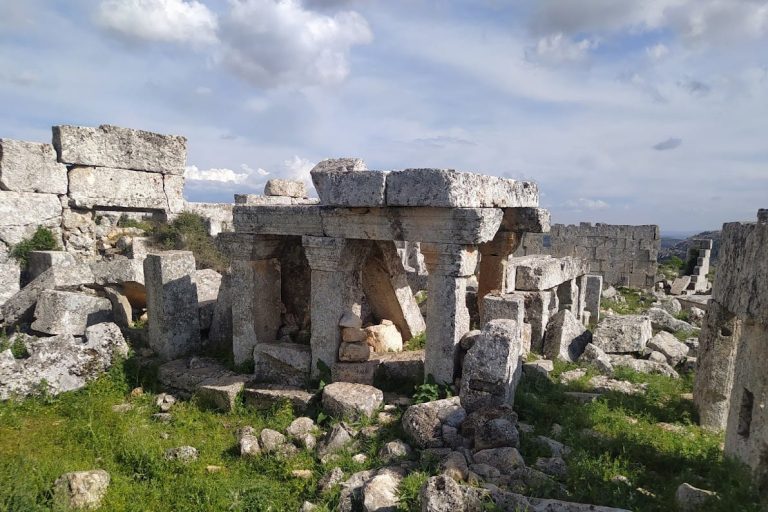
The temple suffered heavy damage during Turkish airstrikes in late January 2018, during the Afrin offensive. At least 60 percent of the structure appears to have been reduced to rubble, and images released after the attack showed the destruction of the entire front facade. In December 2019, members of the Hamza Division, a Turkish-backed Syrian National Army group, removed the monumental basalt lion discovered at the site in the mid-1950s. Remote-sensing analysis by January 2022 indicated that nearly all of the high and low mounds had been bulldozed, apart from the stone-built temple complex.
Remains
Ain Dara occupies a settlement mound overlooking the Afrin Valley. Fertile plains surround it on three sides, the Afrin River runs a few hundred metres to the west, and a stream from the Ain Dara spring and its small lake crosses the site before reaching the river. The acropolis rises approximately 24 to 30 metres above the surrounding plain in the southern part of the settlement, while the lower town occupies a relatively level area.
Lower Town and Fortifications
The lower town covered a broad level area and retained portions of its western defensive wall. The fortifications included towers and originally enclosed four gates. Excavated or identified remains included the northern gate and sections of the western defenses. Later structures at the site included buildings, public installations, olive presses, bread ovens, an iron-smelting installation, houses, agricultural tools, a church, and a fort with strong towers at the southern corner of the mound.
Temple Complex
Courtyard and Entrance
The temple was a rectangular stone building approximately 30 metres long and 20 metres wide, covering about 600 square metres. It faced southeast and was constructed principally from basalt blocks on limestone foundations. A sandstone courtyard formed the approach. Flagstones paved the court, which contained a chalkstone basin probably used for ceremonies.
Two basalt pillars marked the entrance porch, or portico. The porch and adjoining broad hall were apparently open and unroofed. A sphinx, a mythical creature with a human head and a lion’s body, and two lions flanked the basalt entrance steps. A relief of a cherub, a winged supernatural figure in ancient Near Eastern art, decorated the exterior. The upper parts of the temple probably had a mud-brick structure faced or panelled with wood, but that construction has not survived.
Inner Rooms and Raised Platform
The temple contained three successive spaces: the entrance porch, a middle room, and an innermost sanctum, the most sacred room of a temple. The middle room measured approximately 6 by 15.5 metres and carried lion reliefs, guilloche patterns, and panels resembling windows. The principal hall was approximately square, about 16 by 16 metres. Reliefs and a stele, an upright stone slab bearing an image or design, stood at its rear, while basalt reliefs faced the lower wall panels.
The innermost room stood on a platform approximately 0.75 metres high. A niche probably held a statue of a god or goddess, and sockets and grooves in the walls indicate a former wooden screen. A ramp joined the principal hall to the raised platform. The building’s elevation was emphasized by three sets of steps, at the entrance, between the first and second rooms, and before the inner platform. Some archaeologists have proposed a second storey, although no staircase to it has been found.
Surrounding Corridors and Decorative Features
Corridors or an ambulatory, a passage running around a building, surrounded the temple on three sides. The multistoried circulation area contained side chambers, and at least one entrance on the south led into it. These chambers belonged to the third construction phase and may have formed part of the earlier temple platform rather than the main building itself.
The temple floors were probably paved with limestone and basalt. Several paving stones carry undeciphered vertical lines and worn engravings. These marks have not been identified as Luwian hieroglyphs and may instead have been construction marks or signs associated with a stonecutter or builder. Before the entrance, a pair of enormous bare footprints, each about one metre long, was carved into the limestone paving. Other footprints appeared beyond the pair, on the threshold, and along the entrance toward the second room. Their meaning is uncertain. They have been interpreted as references to a deity’s arrival, ritual markers for priests or pilgrims, signs of the temple’s sanctity, or a mythological entrance into the shrine.
Sculpture and Later Finds
Reliefs from the temple depict lions, sphinxes, winged human-animal figures, and other creatures. The deities shown wear shoes with curled toes. False recessed windows with figure-eight lattice patterns were solid decorative features rather than openings. A basalt architectural base found in secondary use carries a row of mountain gods, bird-men, and lion-men with raised arms. Excavators suggested that it may once have surrounded the raised third room or supported a suspended wooden structure or divine symbols within it.
Excavations recovered a life-size basalt plaque or relief depicting Ishtar and female figurines associated with her worship. A stone amulet from the Achaemenid period, when the Persian Achaemenid Empire ruled much of the Near East from the sixth to the fourth century BC, depicts Ahura Mazda beneath a winged solar disk. Architectural remains from that period lay above the temple ruins. Numerous basalt sculptures and architectural fragments were also found, including the colossal lion that led to the temple’s discovery. That lion was later removed and is no longer at Ain Dara.
Nearby sites