Stobi: An Archaeological Park of a Paeonian, Roman, and Early Christian City



Site at a Glance
- Rating
- 4.7
- Popularity
- Low
- Country
- North Macedonia
- Primary era
- Classical
- External website
- Open
- Eras represented
- Classical, Medieval
- Civilizations
- Byzantine, Roman
- Site type
- City
On this page32 sections
History
Stobi is an archaeological site in North Macedonia that developed from a Paeonian settlement into a Hellenistic, Roman, and Early Christian city. Its beginnings probably lay in the Archaic period, but substantial evidence appears during the Hellenistic period, when the town was established or expanded not long before the reign of Philip V of Macedon. Positioned near the confluence of the Crna and Vardar rivers, Stobi grew into a commercial, strategic, and religious center whose history extended from antiquity into the early medieval period.
Paeonian and Hellenistic Stobi
Paeonia was an ancient region of the central Balkans, associated with the Paeonians. Archaeological traces from the Archaic and Classical periods at Stobi are sparse, while the Hellenistic period brought a much more substantial settlement. The town’s earliest written reference appears in Livy’s account of Philip V’s victory over the Dardanians near Stobi in 197 BC. In 167 BC, after the Roman occupation of Macedonia, Stobi became the principal salt-trading center of the third administrative district.
The settlement occupied an important position at the meeting point of the Erigon, now called the Crna, and the Axios, now called the Vardar. Routes from the Danube and the Aegean passed through this wider region, as did the Via Egnatia and Via Militaris. These connections supported Stobi’s commercial activity and gave it strategic and military value.
Roman Civic Development
During the relatively stable period of Roman imperial rule known as the Pax Romana, especially in the 1st to 3rd centuries AD, Stobi expanded demographically and reached its largest known area. During Augustus’ reign, the town became a Roman civic community and later a municipium, a Roman town whose inhabitants possessed defined civic rights within the Roman system. Some citizens held ius Italicum, a privileged legal status granting communities rights comparable to those of Italian towns. Others belonged to the Aemilia and Tromentina tribes.
Under Vespasian, Stobi began producing bronze coins. Its mint remained active until the reign of Elagabal in the early 3rd century. The coins and religious sculptures from the town reflect the Greco-Roman religious sphere. They include representations of Apollo, Artemis, Asclepius, Dionysus, Nemesis, Zeus, Tyche, Aphrodite, Hygieia, and Telesphorus. Temples and deities also appear on the coinage, providing evidence for at least two urban temples. The known issues include images of Victory, bulls, four-column temples, soldiers, river gods representing the Erigon and Axios, and scenes associated with Fortuna, Pluto, Persephone, Demeter, and Mercury. The limited range of types has led to the interpretation that the mint may have produced mainly commemorative or ceremonial coins.
A Jewish community existed at Stobi by at least the Roman period. An inscription identifies Tiberius Claudius Polycharmos as the father of the synagogue. He rebuilt a synagogue and constructed his house beside it, linking civic benefaction, private residence, and Jewish religious life within the city.
Destruction and Late Antique Rebuilding
Stobi suffered extensive damage during the second half of the 3rd century. An earthquake has not been excluded, but the destruction is generally associated with the Gothic and Herulian incursions of 267 to 269. The town was rebuilt afterward, and its urban form changed substantially during the 4th and 5th centuries.
Christianity had become institutionally established at Stobi by 325, when Bishop Budius took part in the First Council of Nicaea. The council was a major gathering of Christian bishops that addressed church doctrine and organization. Stobi subsequently became an important Christian center, and its bishops continued to attend church councils into the 7th century. As capital of the province Macedonia Secunda, the city may have held a position beyond that of an ordinary episcopal center and may have functioned as a metropolitan seat.
Emperor Theodosius I visited Stobi in 388. There he issued two edicts prohibiting heretical gatherings and public religious debates. The Synagogue Basilica was built over earlier synagogues at the end of the 4th or the beginning of the 5th century, reflecting the major religious and architectural changes taking place in the city.
Hunnic Destruction and the End of Urban Life
In 447, the Huns destroyed Stobi. Fired layers and Hun weapons preserve evidence of the attack. Theodoric and the Ostrogoths later plundered the town while travelling toward Dyrrachium, although their action was less destructive than the Hunnic assault. A major earthquake in 518 caused further damage, followed by incursions by Avars, Slavs, Kutrigurs, and other groups during the 6th century.
Urban life declined and effectively ended during the later 6th century. The episcopal institution survived formally into the 7th century, but archaeological evidence indicates that later activity was limited rather than representing the continuation of the ancient city. Slavic groups occupied the area, as shown by medieval graves. A reference records Basil II’s victory over a military garrison at Stobi in 1014, while the archaeological remains indicate only restricted medieval occupation.
Excavation and Protection
Modern investigation began during the First World War. The Palikura Basilica was discovered and excavated in 1916, followed by the discovery of the Cemetery Basilica in 1917. Major excavation campaigns took place from 1924 to 1936, with further work in the 1950s, 1960s, 1970s, and 1980s. Later investigations examined individual buildings and sections of the fortifications. Systematic excavation of the Theatre resumed in 2009, followed by conservation and plans for partial reconstruction.
Stobi is protected as an archaeological site and immovable cultural heritage. Its official cultural-heritage designation dates from 1950. The archaeological site covers approximately 16 hectares, while the Roman town enclosed by its fortifications occupied about 27 hectares.
Remains
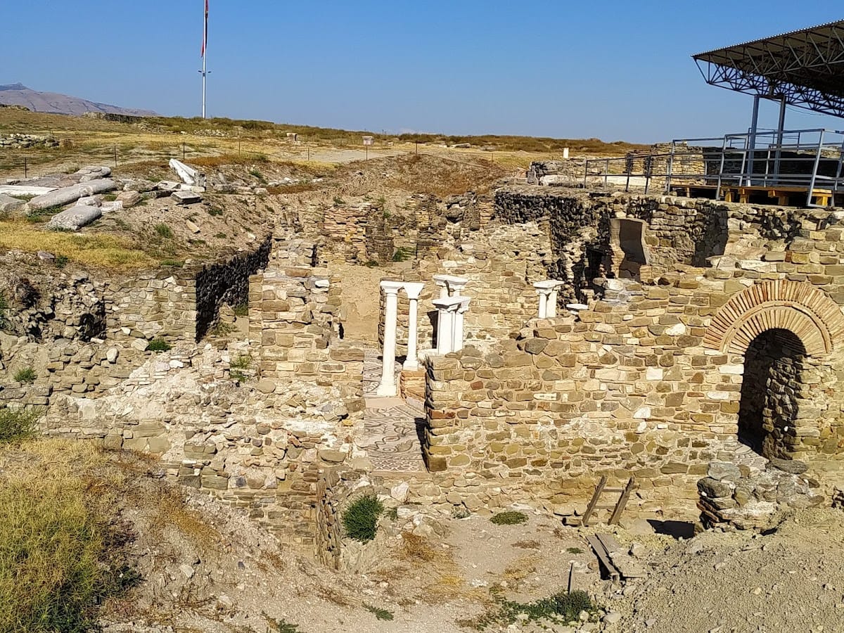
Stobi was arranged on terraces descending toward the Crna River, close to its confluence with the Vardar. The excavated city contains public and private buildings, streets, baths, religious complexes, cemeteries, water-supply installations, and successive defensive walls. Its remains reveal repeated changes in urban organization, including the reuse of earlier architectural elements in later streets, churches, fortifications, and houses.
Public Streets and Performance Buildings
Theatre
The Theatre occupies the southern edge of Stobi on a slight slope or level area supported by radial and circular walls. Its construction developed through three phases. The first began at the end of the 1st century AD but remained unfinished. Work resumed in the middle of the 2nd century with a different design, and repairs followed an earthquake at the end of the 3rd century.
The auditorium contained approximately 33 to 35 rows divided into two seating zones by a central diazoma, a passage separating seating levels. It could hold about 7,600 to 7,638 spectators. Marble seats bear the names of families and individuals, and the seating may also have been organized according to tribal affiliation. The stage building stood about 13 metres high and had a two-level facade decorated with pink marble columns. The orchestra, auditorium, and stage building were separate architectural elements.
Post-holes indicate that a protective net stood in front of the lowest rows. After the earthquake, a wall replaced the net and obstructed the view from some of the front seats. The Theatre hosted gladiatorial combats, animal hunts, mimes, and dances. In its third phase, side walls were added to the stage building, gates separated the passageways beside the stage from the orchestra, and a room in front of the stage became a shrine of Nemesis, the goddess associated with retribution and the restoration of proper balance.
After the Theatre was abandoned at the end of the 4th century, it served as a dumping ground and quarry. Its blocks and seats were reused in the eastern fortification, the basilicas, Via Sacra, Porta Heraclea, and other later structures. Modest houses stood on the mound formed over the Theatre during the 6th century.
Via Sacra
Via Sacra, or the Sacred Street, extended for approximately 75 metres from Porta Heraclea to the Episcopal Basilica. Sandstone slabs paved the street, which was bordered by colonnades and arcades. The columns stood on a continuous base made partly from reused Theatre seats. Near the Episcopal Basilica, the street formed a semicircular court surrounded by columns and small rooms probably used as workshops. An equestrian statue once stood on a central pedestal, and some scholars have proposed that it represented Theodosius I. The street has not been fully excavated, but a reconstruction was in place at the beginning of the 5th century.
Episcopal Complex
Old Episcopal Basilica
The Old Episcopal Basilica stands west of the Theatre. Built in the first half or middle of the 4th century, it is considered the oldest Christian church in North Macedonia. Its three aisles were separated by a colonnade, and the building was expanded eastward during the second half of the 4th century.
The mosaic floor was arranged in three zones. An inscription names Bishop Eusthatius as the commissioner of the reconstruction. Frescoes on the northern and southern walls show geometric ornaments, animals, and saints. Later excavation beneath the monumental Episcopal Basilica exposed the church’s mosaic floor, a six-line inscription, a Christogram, and wall painting.
Monumental Episcopal Basilica
The monumental Episcopal Basilica was built during the first half of the 5th century without destroying the remains of the older church. Foundations approximately 4 metres deep supported the new building. Its two-storey structure incorporated columns and seats taken from the Theatre. An atrium opened from Via Sacra into a three-part narthex, or entrance hall, followed by a nave, side aisles, associated rooms, an ambo, or raised liturgical platform, an altar, and a double apse, the curved end of the church.
A crypt occupied the inner apse. The outer apse had a window with massive impost capitals, and some capitals were painted and gilded. Marble plates decorated with cross reliefs formed the altar screen. The southern aisle retained two mosaic floors laid one above the other. A coin beneath the ruins indicates that the basilica was destroyed after 569 or 570.
Conservation of the large mosaic began in 1991 and ended in early 2015. The mosaic was then reinstalled, and the work revealed a previously unknown third laying phase.
Baptistery
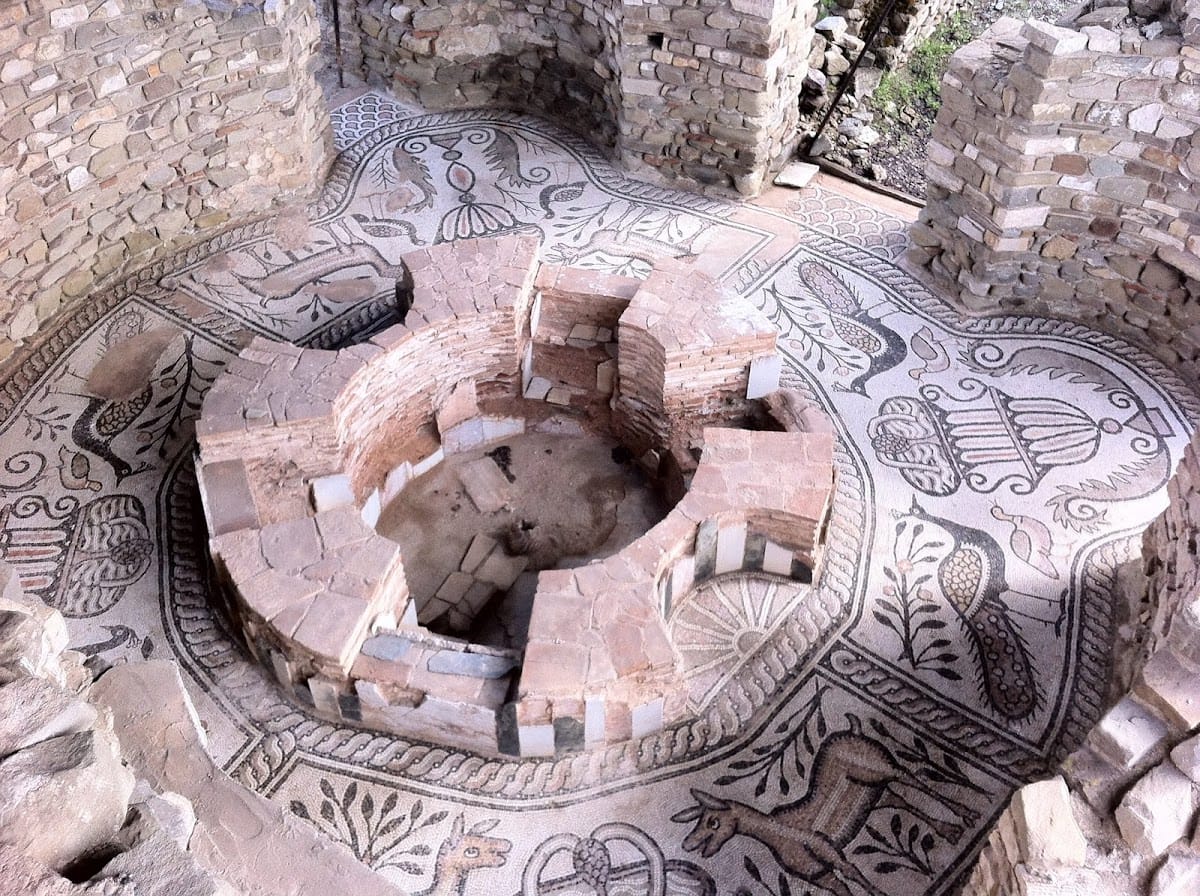
The baptistery south of the Episcopal Basilica had a quatrefoil plan and a dome. Its central piscina, a baptismal basin, had steps on two sides and was decorated with mosaics showing peacocks and deer beside kantharoi, large vessels associated with water and ritual imagery. The composition alludes to Psalm 42. From the beginning of the 6th century, a marble kantharos was added above the piscina, while frescoes of saints decorated the walls.
Residential and Commercial Quarters
Via Principalis and the Theodosian Palace
Via Principalis Superior, or Main Upper Street, continued north from Via Sacra after turning slightly east near the Episcopal Basilica. Domus Fulonica stood on its western side, while the Episcopal Residence, the Theodosian Palace, and the House of Peristeria stood on its eastern side. The street has not been completely excavated. Via Theodosia ran between the Theodosian Palace and the House of Peristeria, linking Via Principalis Superior to the north with Via Principalis Inferior to the south.
Via Principalis Inferior ran parallel to the upper street. The Theodosian Palace and the House of Peristeria stood on its western side, while the Large Bath, House of Polycharmos, Synagogue Basilica, Civil Basilica, and North Basilica stood on its eastern side. Although the street itself has not been excavated, a waterline beneath it supplied the Large Bath and Public Fountain. Via Axia ran east to west between the Large Bath and House of Polycharmos, passing beside the House of Peristeria and continuing toward the defensive wall. A drainage channel covered with sandstone slabs was recorded near the house.
The Theodosian Palace was a large residential complex in the centre of Stobi, between the two Principalis streets. Its name derives from the unconfirmed assumption that Theodosius I stayed there in 388. The northern and southern parts had separate entrances and were not connected by a shared entrance. The southern section is also called the House of Parthenius because of a seal inscription reading “Of Parthenius.”
The northern section had rooms arranged around a columned peristyle, an open court surrounded by columns. Mosaic floors covered parts of the complex, and an eastern pool was enclosed by parapet blocks of pink marble. After the palace was destroyed, the pool contained bronze figures of satyrs, Apollo, Aphrodite, and a household guardian deity, as well as a marble head of Serapis. Some sculptures, including the satyrs, date to the 2nd century BC, although the palace itself was built in the 4th century AD.
The southern section contained a smaller peristyle and rooms including a storage room with ten large storage jars. Two vaulted chambers southeast of the complex are known as the “Prison.” Human remains were found there, although the chambers may instead have been cellars or economic rooms. The palace was destroyed during the 5th century, and modest houses built over its ruins in the 6th century incorporated surviving walls.
House of Peristeria
The House of Peristeria was a multi-room residential and economic complex enclosed by streets on all four sides. Steps indicate that it had at least two floors. Its southeastern section contained a peristyle, two dining rooms, a bath, an open court, and smaller rooms. The western dining room had a sandstone floor, while the eastern one had a mosaic floor with a central fountain.
The mosaic used geometric and animal motifs together with Christian symbolism. An inscription contains four names, two of them associated with the Peristeria family. The house dates to the beginning of the 5th century. Its economic northwestern section contained altered rooms arranged around two courts, a pottery kiln, and substantial pottery debris. Earlier walls from the 1st and 2nd centuries AD and graves from the 3rd to 2nd centuries BC lay beneath the open court.
Domus Fulonica
Domus Fulonica was first interpreted as a textile workshop because shells and spindle whorls were found there. Later excavations identified it as a private house with two construction phases, dating from the end of the 3rd century and the end of the 4th century AD. The shells were ordinary food remains rather than material used to produce purple dye. A ring inscribed “GR” led some researchers to suggest the alternative name House of GR.
The 4th-century house had a peristyle of 12 columns with a well at its centre, and rooms opened around the court. Its apsidal hall contained four niches that once held sculptures. The building was destroyed in the middle of the 5th century, probably during a Hun attack. Modest houses were later built over the ruins and reused some of its walls. Hellenistic cremation graves beneath the complex were excavated in 1975 and 2001.
House of Polycharmos
The House of Polycharmos, also called the House of Psalms, shared the southern wall of the Synagogue Basilica. A western entrance led into the basilica’s atrium, while the main entrance opened through a portico onto rooms arranged around a central peristyle of eight columns. The court contained a pool and a well, and stairs indicate that the house had a second floor.
Mosaics showed birds, vessels, and a scene illustrating Psalm 42. Two fawns stood on either side of a kantharos from which water flowed. The building may have been erected in the 2nd century during the first synagogue phase. It remained in use during the second phase and became Christian property in the 5th century, when the mosaic in its dining room was installed. Modest houses occupied the site during the 6th century.
Casa Romana
Casa Romana, or the Roman House, lies in the northeastern part of Stobi, separated from the eastern defensive wall by a small street. One room was completely excavated and nine others were partly exposed. Frescoes depicted Ionic pilasters and human figures. The house was built in the middle of the 1st century AD, and its frescoes were repainted in the 2nd century. Flooding from the Crna River prevented excavation of the whole complex, and the building was destroyed by flooding at the end of the 3rd or beginning of the 4th century AD.
Religious and Civic Buildings
Synagogue Basilica
The Synagogue Basilica is an Early Christian three-aisled basilica south of the Civil Basilica. Its name derives from two synagogues discovered beneath it. The basilica had an atrium entered from Via Principalis Inferior, a narthex to the east, rooms communicating with the House of Polycharmos, colonnades, and a floor of tiles and sandstone slabs. A reliquary with a cross-shaped opening stood in the altar.
Synagogue I dates to the 2nd century AD. Synagogue II was built over it toward the end of the 3rd or beginning of the 4th century. The later synagogue was larger and had geometric mosaic floors. A menorah was inscribed in the mortar of one wall. An inscribed column records that Tiberius Claudius Polycharmos donated part of his house for the synagogue, while a marble plate found in 1994 records that Alexander, a synagogue guardian or curator, rebuilt its porch at the end of the 3rd or beginning of the 4th century. Hellenistic buildings and a coin hoard dating from 211 to 125 BC lay beneath the basilica’s narthex.
Civil Basilica
The Civil Basilica occupied the area between the North Basilica and the Synagogue Basilica. It had three aisles, but its latest phase contained no Christian elements. Seven construction phases were identified, and the building ultimately served a secular rather than sacred purpose. Excavation revealed bronze objects from the 5th century BC, a 1st-century AD wall painted with a wild duck, Hellenistic layers from the 3rd and 2nd centuries BC, and a poorly preserved 4th-century building known as Basilica B. Eighteen graves from the 11th to 13th centuries were also found in the area.
North Basilica
The North Basilica is a three-aisled Early Christian church with an open atrium entered by steps from Via Principalis Inferior. The atrium had a sandstone floor and a small marble-lined pool beneath a three-part niche. On the northern side stood a baptistery with a hexagonal piscina. It was entered through a small rectangular catechumenion, a room used for instructing people preparing for baptism, which connected with the atrium. Its mosaic was divided into eight squares containing birds and a kantharos.
The basilica was built toward the end of the 5th or the beginning of the 6th century. During the Middle Ages, its ruins became a cemetery containing 23 graves from the 9th to 12th centuries and one grave from the 14th century. The latest grave contained 80 silver coins of Serbian kings and the Venetian Republic, together with a decorated silver plate probably made in the West.
Small Bath and Public Fountain
The Small Bath stood near the apse of the Synagogue Basilica. Its eastern part was lower than its western part, probably because of earthquake-related ground disturbance. The complex included a changing room with a sandstone floor, an apsidal room probably used as a cold-water room, a warm room with a small pool, two additional heated apsidal rooms, an underfloor heating system, a fireplace, and a latrine with a drainage channel. Its date remains broad, between the 4th and 6th centuries AD.
The Public Fountain stood at the southeastern corner of the House of Peristeria, in a small square formed by Via Axia and Via Principalis Inferior. Built in Late Antiquity from reused architectural elements, it received water through a covered channel beneath Via Principalis Inferior. Water collected in a long reservoir before passing through several pipes into troughs. Three pipes and three stone troughs are described.
Large Bath
The Large Bath was built at the end of the 3rd century AD and entered from Via Axia. Excavated in 1931 and 1932, it was conserved in 1960. Its western changing room contained low stone benches and an arcade. Beneath it were a colonnade and two sculptures from the early 3rd century, one showing Venus with a dolphin and the other depicting an honoured citizen.
The complex also contained a cold-water room, a heated room with an eastern apse, five external furnaces, heated or warm-water pools, and an underfloor heating system. The reconstructed bath remained in use during the late 6th century.
Building with Arches
The Building with Arches stood on the eastern terrace near the Inner Defensive Wall. This rectangular public building was erected at the end of the 1st or beginning of the 2nd century AD. Its two western apsidal halls had walls of brick and stone, massive pilasters, and arches, while the upper storey followed the same design. The halls had opus sectile floors, a decorative technique using cut pieces of marble fitted into geometric or figured patterns. Pink and green marble slabs formed the floors, and gilded sculptures stood in frescoed niches.
The building went out of use at the beginning of the 4th century. A cistern was installed in its large rectangular room, with a drainage channel leading west toward the Small Bath. A structure with massive steps, probably a small pagan temple, was built over the entrance. By the end of the 4th century, the area had become a cemetery. During the first half of the 6th century, upper-storey walls collapsed over the graves, and flood traces appeared in the soil covering the destruction. The building was not quarried after abandonment, leaving wall decoration and architectural elements in place. The excavated area has the working name Roman Forum.
Fortifications and Cemeteries
City Walls and Gates
The fortifications originally enclosed about 27 hectares. The eastern wall extended for approximately 450 metres and stood about 10 metres from the Crna River. Flooding led to the construction of a new wall west of the earlier one at the end of the 4th or beginning of the 5th century. Its foundations cut through earlier public buildings, including the Building with Arches. The later fortification also incorporated seats from the Theatre.
About 14 rectangular towers remain visible, and the wall averages approximately 2.3 to 2.5 metres in width. Porta Heraclea, also called Porta Sacra, was the only known gate until a second gate was discovered in the southeastern fortification in 2010. Two towers were added 9 metres from Porta Heraclea at the end of the 4th or beginning of the 5th century. Their interpretation remains uncertain: some scholars regard them as marking a double gate, while others identify them as a gateway within an advanced outer defence. The southeastern gate was closed during the 6th century.
Extra Muros Basilica
The Extra Muros Basilica stands 120 metres southwest of the City Wall. It is a three-aisled Early Christian church with a narthex, reused columns and capitals, and a central mosaic floor decorated with Early Christian motifs. A baptistery with a circular piscina occupied the southern rooms. Built in the suburban zone from the end of the 5th through the 6th century, the basilica later contained a small medieval church within the altar area of its ruins.
Cemetery Basilica
The Cemetery Basilica lies about 250 metres southwest of Porta Heraclea in the Western Necropolis. It has three aisles, a western narthex with attached rooms, and a central-nave mosaic dating from the first half of the 5th century. Approximately 50 tombs were found inside and around the church. A large cross-vaulted chamber south of the basilica contained three arcosolia, arched recesses containing tombs. The church served as a burial place for wealthy Christians of Stobi.
Palikura Basilica
The Palikura Basilica lies about 2 kilometres southwest of Stobi, opposite the village of Palikura on the road to Heraclea Lyncestis. It has three aisles separated by colonnades of five columns and a narthex. The columns and capitals were reused from older buildings. Four connected rooms stood east of the basilica, and one may have been a baptistery or a place associated with a martyr’s cult. Its isolated position and associated rooms have led to the interpretation of the complex as a monastery, although its precise date remains uncertain within the late 5th to early 6th centuries.