Chufut-Kale: A Medieval Fortified Cave City in Ukraine


Site at a Glance
- Rating
- 4.8
- Popularity
- Medium
- Country
- Ukraine
- Primary era
- Early Modern
- Eras represented
- Medieval, Early Modern
- Civilizations
- Byzantine, Crimean Khanate, Golden Horde
- Site type
- City
On this page12 sections
History
Chufut-Kale is a medieval fortified city and cave settlement in Ukraine, near Bakhchysarai, developed in the Crimean Mountains from the fifth or sixth century as a possible Byzantine frontier stronghold. Its position helped protect the Maryam-Dere and Ashlama-Dere defiles and the approaches to Chersonesus. The earliest population was predominantly Alan, and the settlement may have included a Christian basilica. Some researchers instead place the emergence of the fortified settlement in the tenth or eleventh century, and written evidence before the thirteenth century is limited.
Qırq Or under the Golden Horde
The fortress first appears in written records in 1253–1254 under the name Qırq Yer or Qırq Or, usually understood as “Forty Fortifications” or “Place of Forty.” During the thirteenth and fourteenth centuries it formed the center of a small principality dependent on the rulers of the Crimean ulus of the Golden Horde. It may also have served as the seat of a tümen, a military and administrative district. Golden Horde forces led by Nogai raided Qırq Or in 1298–1299, while the fortress provided refuge for local Alans during periods of danger.
From the fourteenth century, Qırq Or became the capital and most powerful fortress of the Crimean ulus. The ruling family of Janike Khanim, daughter of Tokhtamysh, controlled the stronghold. Janike was born there and probably ruled it for about seventeen years, until her death in 1437. She sheltered her brother Qadir Berdi from her husband, the Golden Horde commander Edigei. Qadir Berdi campaigned against Edigei in 1420, and both men died soon afterward, Edigei in battle and Qadir Berdi from wounds. Janike then became the senior member of the Tokhtamysh lineage and supported Haci I Giray in his struggle for power in Crimea.
Capital of the Crimean Khanate
A durbe, or Islamic mausoleum, was built at Qırq Or for Janike in 1437. Haci I Giray returned to Crimea in 1441 and founded the independent Crimean Khanate, a Muslim Tatar state ruled by the Giray dynasty, which claimed descent from the Mongol imperial line through the Golden Horde. Qırq Or became the khanate’s first capital. In the second half of the 1430s or the early 1440s, Haci I Giray moved his principal residence there from Solkhat, now Stary Krym.
Qırq Or prospered during the early Crimean Khanate. Haci I Giray and his successors minted coins in the fortress from 1455 to 1551. In 1459, Haci I Giray granted exemptions from taxes and fees to the city’s Muslim, Jewish, and Christian communities, and a charter of 1468 also mentions Armenians. The population included these groups, with Karaites eventually forming the majority. Karaite settlement began in the fourteenth century, and restrictions on Karaite residence elsewhere in the khanate helped concentrate the community at Qırq Or. Under the khans, the Karaites developed internal judicial autonomy and made the city a center of religion, learning, commerce, and crafts.
Political struggles continued within the fortress. In the 1420s, Qırq Or was controlled for several years by Devlet Berdi, son of Tash Timur and uncle of the future first Crimean khan. In the late fifteenth century, the stronghold held important prisoners and envoys, including a Lithuanian envoy imprisoned there in 1493.
Relocation of the court and later decline
The khan’s residence moved to Devlet Saray at Salachik in the early sixteenth century and later to the palace around which Bakhchysarai developed. Crimean Tatars gradually left Qırq Or, while many Karaites remained, partly because they were prohibited from living in Bakhchysarai. By the seventeenth century, the name Chufut-Kale, meaning “Jewish Fortress,” was increasingly used. In this setting the name carried a negative or scornful meaning.
Chufut-Kale retained military and custodial importance after the court moved away. During a civil war in 1628, Mehmed Giray III and his brother Shahin Giray, the qalga-sultan or designated deputy of the Crimean khan, resisted a siege there. The fortress continued to hold high-ranking captives, including the Polish hetman Mikolaj Potocki, the Muscovite boyar Vasily Buturlin, and Prince Andrei Romodanovsky. Vasily Sheremetev was imprisoned there from 1661 until 1681. He and Romodanovsky were released after the Treaty of Bakhchysarai.
A state mint operated at the fortress, and during its eighteenth-century prosperity Qırq Or contained more than 500 estates. In 1731 the Karaites established Crimea’s first printing press there. From 1734, it printed books mainly in Hebrew. After the Russian Empire annexed Crimea in 1783, restrictions on Karaite and Krymchak residence were abolished. Residents moved to other Crimean towns and villages, and the settlement declined rapidly. A Karaite school operated from 1844 to 1867. By the middle of the nineteenth century, Chufut-Kale was almost deserted, and by the end of that century only a caretaker’s family remained. The Karaite religious center moved to Yevpatoria during the nineteenth century.
Last residents, investigations, and heritage status
Abraham Firkovich, a Karaite religious teacher, researcher, and collector, was among the last residents of Chufut-Kale and lived there until his death in 1874. Solomon Beim, a Karaite gazan, or religious officiant and teacher, was another late resident. Plans to resettle additional Karaite communities at the site were not carried out. A tradition claims that Catherine II visited Chufut-Kale and spent a night there in 1787, but the visit is regarded as legendary rather than historically confirmed. The fortress was also visited by figures including Adam Mickiewicz, Lesya Ukrainka, Ilya Repin, and Maximilian Voloshin.
Archaeological investigations took place in 1925–1928, during the 1950s, in 1983 and 1987–1988, and in 2000. Work also examined early medieval burial grounds in the Maryam-Dere valley and the Karaite cemetery of Balta-Tiymez, where epigraphic research continued from 1997 to 2014. The large underground hydraulic installation known as Tik-Kuyu was discovered in 1998 and excavated from 2002. That work clarified the scale of the water system and produced a major coin hoard.
Chufut-Kale forms part of the Bakhchysarai Historical and Cultural Preserve. In Ukrainian heritage protection it is a national monument, with the protected complex including its fortifications, gates and towers, Janike Khanim’s tomb, two kenassas, or Karaite houses of prayer, and an eighteenth-century residential building. The site was included in Ukraine’s 2012 tentative nomination of the Cultural Landscape of the Cave Cities of Crimean Gothia to the UNESCO World Heritage List. Since October 2015, it has also held federal-level cultural-heritage status in the Russian legal system. Since 2014, the site has been under Russian occupation, while Ukrainian authorities have sought international monitoring of heritage sites in the occupied territory.
Remains
Chufut-Kale occupies a rocky, promontory-like plateau whose highest point is about 581 meters. Steep slopes protect most sides, while a pedestrian approach reaches the relatively level summit from one direction. The settlement is divided into three principal areas: Burunchak, an open tract of about 26 hectares; the Old City, covering more than 7 hectares; and the New City, covering more than 3 hectares between the Middle and Eastern defensive walls. Burunchak was formerly used for grazing and was reportedly used as the khan’s menagerie in the eighteenth century.
Fortifications and settlement areas
The Old City occupies the narrowest part of the plateau. A low enclosure separated it from Burunchak, while the Middle defensive wall divided it from the New City. The New City contained residential buildings and the khan’s mint. The early defensive system centered on the Middle Wall, which crosses the plateau at its narrowest point. Its Orta-Kapu, or Middle Gate, opened beside a rock-cut ditch. Two shorter ditches near the northern flank protected a postern used for sorties, and short walls blocked ravines along the cliffs. Early cave rooms beside these barriers probably sheltered guards.
The later eastern defensive wall and its Great Gate, Biyuk-Kapu, formed another fortified line. The wall has been dated either to the thirteenth and fourteenth centuries or to the sixteenth century, and its design adapted late medieval defenses to firearms. A ditch ran along its front. Along the cliff edge and within the Old City, the surviving remains include defensive structures, the ruins of a palace and mosque, a mausoleum, two Karaite kenassas, numerous rock-cut rooms, and residential ruins. The New City included houses, the mint, the Firkovich estate, a guest house, a caretaker’s house, and further cave structures.
Walls and gates
A surviving defensive wall attributed to the tenth century was built in three layers. Carefully dressed limestone blocks formed the outer faces, enclosing a core of rough broken stone bonded with lime mortar. The wall reached about 5 meters in total thickness. The site plan also identifies the Small Gates, the Middle and Eastern Gates, the Middle and Eastern walls, and the Great and Small defensive ditches.
Cave structures
About 200 cave structures are known at Chufut-Kale. Most were cut in the seventeenth and eighteenth centuries for barns, storage, workshops, and other estate buildings, while some earlier caves served defensive or refuge functions. Rooms near Kichik-Kapu, the South Small Gate, reportedly housed the poorest inhabitants in the seventeenth century. Other named features include a bath cave called Hamam-Koba, a mastic cave known as Sakiz-Koba, and a water-collection basin.
Religious and residential remains
The Great Kenassa is traditionally assigned to the fourteenth century, although its architectural features and current interpretations of the settlement’s development suggest that it may have originated no earlier than the seventeenth century. The Small Kenassa was built at the end of the eighteenth century, when part of the Karaite population moved to Chufut-Kale from the abandoned settlement of Mangup. Both houses of prayer survive among the principal standing remains.
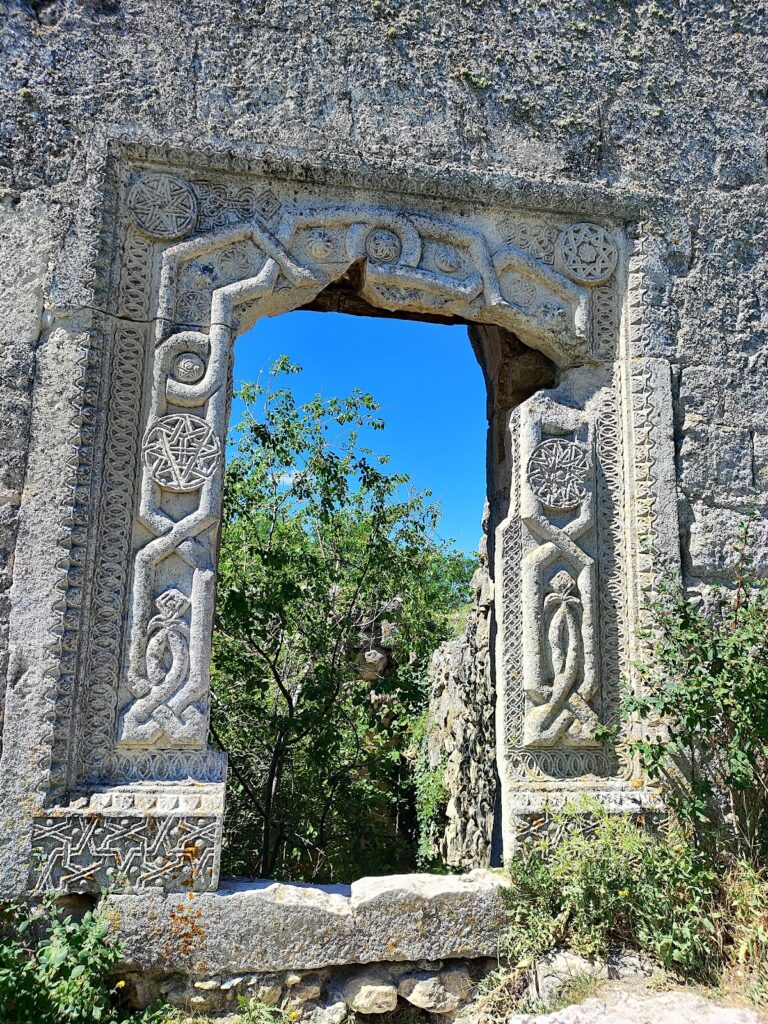
Janike Khanim’s mausoleum, built in 1437, is an octagonal monument of fifteenth-century Seljuk architecture. It has carved columns and a tall carved portal. Inside, a raised marble tombstone bears an Arabic inscription naming Janike Khanim as the daughter of Tokhtamysh Khan and giving her death as Ramadan 841. A separate tradition says that Janike was killed while defending the city and that the mausoleum stands where she died. The same tradition describes a palace beside barracks for 1,000 soldiers, but that account is not established history.
The Firkovich residential estate survives and contains an exhibition on Karaite culture. The site plan also identifies the former Karaite school, the old bazaar, the ruins of Karaite community buildings, and the Firkovich and Chal-Boryu estates. The mint, palace, many houses, and other buildings survive as ruins or archaeological traces. Most of the settlement is now in ruins, while the kenassas, the mausoleum, numerous caves, fragments of the defensive walls, and the Firkovich estate remain visible.
Water systems and archaeological finds
The early medieval water installation called Tik-Kuyu, or “Vertical Well,” combines an inclined gallery about 120 meters long with a vertical shaft more than 30 meters deep. Two basins lie at the bottom, and a tower once stood above the gallery entrance near Kichik-Kapu. Excavation also revealed a spiral stairway about 30 meters long. The system may have offered concealed access to water and may additionally have served as a refuge or ritual space. The Kopka-Kuyu shaft well lies in the New City near the Firkovich estate. By the seventeenth century, the wells no longer contained water, and pack animals brought supplies from the Gazi-Mansur and Yusuf-Chokrak springs.
Excavation of Tik-Kuyu produced a ceramic jug containing 4,287 coins with a combined mass of more than 5 kilograms. The hoard included 29 gold coins and one copper coin, with most of the remainder in silver. Its contents included Venetian ducats, an Egyptian gold dinar from the first third of the fifteenth century, Jochid dirhams, Genoese-Crimean coins from Caffa, Qırım, and Qırq Or, a Moldavian groschen probably minted under Alexander the Good between 1415 and 1430, two Byzantine coins, coins of the Principality of Ryazan, and a copper coin from the Lower Volga region.
Balta-Tiymez cemetery
About 300 meters southeast of Biyuk-Kapu, in the upper Jehoshaphat Valley, lies the Balta-Tiymez Karaite necropolis. It contains approximately 7,000 gravestones, including about 3,400 with epitaphs. The earliest epitaphs date from the middle of the fourteenth century. Karaite burials from Crimea, western Ukraine, Lithuania, and other regions continued there until the beginning of the twentieth century, extending the physical record of the community that shaped Chufut-Kale’s later history.
Nearby sites