Castello Vecchio: A Medieval Fortress and Agricultural Estate in Colleferro, Italy


Site at a Glance
- Rating
- 4.3
- Popularity
- Very Low
- Country
- Italy
- Primary era
- Medieval
- Eras represented
- Medieval, Early Modern, Modern
- Civilizations
- Italian, Papal States
- Site type
- Military
- Remains
- Castle
On this page15 sections
History
Castello Vecchio is a medieval castle in Colleferro, Italy, whose successive rebuilding phases reflect the changing military, aristocratic, and agricultural uses of the site. Its exact construction date is unknown, although the complex is associated with a possible fortified castrum, or military stronghold, of the eighth or ninth century controlling the ancient Via Latina. That Roman road connected Rome with communities in Latium and Campania. The earliest masonry complex is generally placed around 1220 to 1230, while later work continued through the medieval and modern periods.
Early settlement and medieval formation
Colleferro may occupy the site of the Volscian city of Verrua or Verrugo, conquered by Rome after successive conflicts in 361 BC. This identification remains conjectural. Materials dating from the eighth century were found accidentally during excavation for a water reservoir in the early 1980s, pointing to an earlier settlement whose character is not established. The castle itself first appears in a document of 1262. Its traditional attribution to the Conti of Segni is also uncertain, since later documentary study proposed that the founders may instead have belonged to the Conti branch of Poli.
The earliest principal complex probably comprised two parallel wings on the southwest and northeast sides, with substantial towers at the northeast and southeast corners. An internal route connected the ranges around a central courtyard. During the mid-thirteenth century, the buildings and curtain walls were repaired or rebuilt, and smaller corner towers were added. Late in that century, external buttresses, overlapping arches, and further defensive walls strengthened the complex. These stages created the fortified nucleus that later alterations would repeatedly modify.
Aristocratic ownership and fiscal records
Castello Vecchio was involved in the inheritance disputes of the Conti family. In 1320, an arbitration award by Stefano Colonna and Annibaldo Annibaldi assigned the castle to Giovanni Conti. Giovanni renounced 12,000 florins owed to him by Nicolò Conti and transferred to him half of Castello di Pruni in the territory of Montelanico, together with estates in the Marittima and properties in Cori and Ninfa. A judgment dated 23 October 1344 assigned the furnishings accumulated in the castle, except for vessels, crossbows, and bows, to Margherita, daughter of Stefano Colonna. The same judgment included half of Castello di Astura and Giovanni Conti’s movable property.
Fourteenth-century salt-tax and hearth-tax lists confirm that the castle remained an occupied settlement. In 1363 it paid an assessment of 10 rubbia, a historical unit used in tax and grain calculations, corresponding to a population of approximately 1,600. By 1416, the assessment had fallen to 3⅓ rubbia, indicating a substantial decline in population. Between the fourteenth century and 1431, the complex also acquired a cistern, church-related structures, and auxiliary buildings in the southwestern wing.
Destruction and military decline
In 1431, troops commanded by Giacomo Caldora, a professional military commander acting for Queen Joanna II of Naples, destroyed Castello Vecchio and Castello di Piombinara. The destruction took place during the war between Pope Eugene IV and forces supported by the Conti and Colonna families. On 24 September of the same year, Pope Eugene IV issued an edict preventing Niccolò Conti from taking part in the castle’s restoration. Responsibility was assigned to the Apostolic Camera, the administrative and financial institution of the papal government, and a fine of 10,000 florins was imposed for non-compliance.
Together with Castello di Piombinara, Castello Vecchio had defended the Sacco Valley and protected Artena and Valmontone. After its destruction, parts of the complex were abandoned, and the site remained in a damaged condition until about 1600. From the seventeenth century onward, its character changed progressively from fortified stronghold to rural farmstead. The central buildings and some towers were adapted for agricultural and residential purposes, while other defensive sections remained in ruin.
Agricultural conversion and nineteenth-century expansion
The castle was not continuously held by the Conti in the eighteenth and nineteenth centuries. Archival evidence also records ownership by the Salviati and Pamphili families. The first documented lease dates from 1779, when a general expansion plan was probably prepared by the architect Francesco Rust for the Salviati family. Between 1779 and 1781, a barn and cattle shed were built, followed by a stepped access route in 1784. These works formed part of the conversion of the former fortress into an agricultural estate.
The Doria Pamphili acquired the complex in 1804, but its agricultural use continued. In 1842, all the rooms were recorded as grain stores, and the southern part of the northwestern range was adapted for new granaries in 1852. Andrea Busiri Vici designed a guardian’s house that was never built and, in 1862 and 1863, directed the raising and straightening of the northwestern range. In 1905, two stepped access routes were rebuilt and the shed in the courtyard was demolished.
Decline, survey, and later interventions
The castle’s lands were gradually sold, first to the railways and later to the expanding urban-industrial complex. As its agricultural function ended, the building entered a period of decline. The 1915 earthquake caused damage. In 1918, Carlo Busiri Vici surveyed the castle, producing plans of its three floors and roofs and four internal elevation-sections. His survey recorded portions that later collapsed, including the north corner and the internal wall of the southwestern wing, as well as the church before subsequent alterations.
The chaplaincies of Santa Barbara and Santo Stefano were suppressed in 1919. After the Second World War, unauthorized occupation affected the building and continued into the present period. The privately owned complex is partly inhabited and is also used for storage and poultry housing. Several restoration projects have been proposed or partly completed. The current approach seeks to recover the complex’s three-dimensional identity without reconstructing a supposedly original form, instead retaining the evidence of its successive transformations. Castello Vecchio is regarded as an important historical monument of Colleferro and as a building contributing to the understanding of late-medieval architecture in southern Lazio.
Remains
Hilltop layout and surviving enclosure
Castello Vecchio stands on the summit of its hill at approximately 270 metres above sea level. The complex occupies an approximately rectangular perimeter measuring 45 by 33 metres, with several structures arranged around a central courtyard. Their differing forms and positions indicate successive additions around a relatively coherent original nucleus. The southwestern and northwestern sides are fully occupied by building ranges. Along the southeastern edge, beside the escarpment, structures of varying thickness and height are supported by buttresses, or projecting masonry masses that reinforce a wall.
Entry is from the northwest through a vaulted corridor crossing the building range and leading into the courtyard. From there, entrances open into the different parts of the complex. Eleven fragmented internal routes preserve the effects of repeated adaptation. An ancient circuit wall surrounded the central fortress nucleus and shared sections of the southeastern and southwestern boundaries. Much of this outer wall has collapsed, while two narrow towers once provided external defense along the southwestern side.
Northwestern and northeastern ranges
Northwestern front and cistern
The northwestern front contains five interconnected parts: the perpendicular ends of the lateral wings, a cistern, the central section above the entrance, and a more internal tower incorporated into the residential nucleus. The central section retains residential rooms. Medieval work associated with the cistern and the church took place between the fourteenth century and the destruction of 1431. Later rebuilding raised and reorganized the range, while twentieth-century changes retained residences in its central part.
Northeastern range
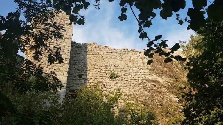
The northeastern range is divided into three parts. Its two lateral wings are ruined, while the central area preserves three pillars, a floor structure, and part of a wooden roof supported by large pointed arches. Tall exterior buttresses are joined by deep arches. The courtyard elevation contains several forms of portals and windows, including paired openings with double pointed arches carved from single large blocks, paired windows formed from five toothed and shaped wedge-stones, and portals using the same alternating tuff and limestone technique. Three high rectangular windows also survive.
The southern part of this range and its tower were adapted for residential use during the seventeenth and eighteenth centuries, while other sections remained ruined. Comparisons with medieval buildings in Alatri and Anagni concern the windows, portals, and capitals. The pointed-arch courtyard portal resembles side portals at the Petrus-spate palace in Anagni, and capitals in that palace and the palace of Mattia de Papa resemble examples in the northeastern and southwestern ranges at Colleferro.
Southeastern and southwestern structures
Southeastern front and keep
The southeastern front preserves the ruined ends of two parallel ranges. A small church is attached to the enclosing wall. It has been altered and converted into accommodation. The keep tower is currently used as an animal shelter. Buttresses contribute to the irregular exterior profile, while two wall sections at the far southern corner use alternating courses of tuff and limestone. These walls originally supported a tower that has disappeared. The church, the southeastern tower, and adjacent areas were remodeled during the agricultural conversion, while the outer southeastern areas remain ruined.
Southwestern ranges and curtain wall
Only two sectors survive on the southwestern side, and both lack internal partitions and roofs. The former external curtain wall shared the southeastern and southwestern wall sections of the fortress, and two narrow defensive towers stood along this side. The southern part of the southwestern wing, known as the stable range, was remodeled in the seventeenth and eighteenth centuries, together with the barn. Nineteenth-century work reorganized the stable and barn areas. Alternating tuff-and-limestone masonry also appears in the base of the Conti tower in Rome and at the base of Palazzo Borghese in Artena, built over the ruins of Castello di Montefortino.
Later fabric and proposed conservation
The seventeenth- and eighteenth-century remodeling enlarged the central part of the northwestern range and adapted the northeastern and southeastern towers for domestic use. In the nineteenth century, the central area of the northwestern wing was raised, the southwestern agricultural spaces were reorganized, and a courtyard shed was added near the northern corner. The twentieth century brought the conversion of the church into accommodation, the ruination of the northern and eastern corners, temporary works using metal frames, boards, and sheet metal, and the demolition of the courtyard shed.
Proposed conservation work would consolidate the entire complex and remove recent accretions while keeping new construction visibly distinct from older fabric. The southern wing would be integrated with surviving masonry, and a more plausible two-pitched roof would be introduced in the outer area. Internally, metal-mesh vaults and arches would suggest the lost structures rather than imitate them. The pointed-arch room in the northeastern block would be consolidated and restored to its original double height, while the central pillars of that wing would be preserved.
The proposed stairs in the northern corner follow the location of stairs still shown in the 1918 survey. The later arrangement of the northwestern block would be retained, and a line of slit windows would emphasize the eighteenth- and nineteenth-century profile of the stable and barn. The eastern corner, the outer southeastern areas, and the external curtain wall would remain ruins. New floors and stairs are proposed for the southeastern tower, together with a bridge-stair for the northeastern range and floors, roofs, and vertical connections for the northern corner.
In the courtyard elevation of the southwestern block, where much of the earlier masonry has disappeared, a continuous stone-panel wall with vertical openings would express the structural rhythm of the lost arrangement. A copper roof would distinguish the new work from the ancient volume. The proposed reuse plan assigns a library to the northeastern wing, an audiovisual room to the former church, and a conference room, antiquarium, or display space for archaeological and historical material, and temporary exhibitions to the southwestern wing and southeastern tower. A refreshment area and a small exhibition room would present the castle’s history and restoration.