Harry’s Walls: An Unfinished Tudor Artillery Fortification

Site at a Glance
- Rating
- 4.1
- Popularity
- Very Low
- Country
- United Kingdom
- Primary era
- Early Modern
- External website
- Open
- Eras represented
- Early Modern
- Civilizations
- English
- Site type
- Military
- Remains
- Fort
On this page8 sections
History
Harry’s Walls are the remains of an unfinished Tudor artillery fortification on St Mary’s in the Isles of Scilly, United Kingdom. Begun in 1551 under the government of Edward VI, the fort was designed in the Italianate bastioned style of gunpowder warfare and probably aimed to defend the entrance to the harbour at Hugh Town against a possible French attack.
Sixteenth-century defence of Scilly
During the sixteenth century, the Isles of Scilly occupied a strategic position on routes linking mainland Europe, Ireland, and Scotland. France and Spain posed continuing threats, while Henry VIII’s Device programme, a programme of defensive construction created in response to the danger of invasion, strengthened fortifications on the English mainland. Although a garrison was established at Ennor Castle on St Mary’s, no new fortification was built in the islands during Henry’s reign.
Henry VIII died in 1547, and his son Edward VI became king. The government was led by Edward Seymour, 1st Duke of Somerset, whose brother inspected the Isles of Scilly. This led to new defensive investment, initially concentrated on Tresco. After Somerset fell from power in 1549, Captain William Tyrrell carried out another survey, and attention shifted to the defence of St Mary’s.
Construction and abandonment
In May 1551, John Killigrew, captain of Pendennis Castle at Falmouth, received orders to build a fort on the small hill between the freshwater pond and St Mary’s Road. Lead was promised for its roof, and an early-1550s document states that a brewhouse and a mill were ready to be sent from South Wales for installation beside the pond.
The proposed design combined Italianate defensive principles with four angular, arrowhead-shaped bastions. It would have been regarded as one of the most advanced military-engineering designs in England at the time. Two light cannons called sakers were reported at the fort in 1554, but the work remained incomplete.
During the reign of Mary I, an unsuccessful attempt was made in 1554 to establish a garrison of 150 men on the island, partly to provide the labour and manpower needed to complete the fort. A further proposal to finish it was made in 1591, but the project was never completed. New defences were built instead at Star Castle in 1593. The name Harry’s Walls comes from the popular but incorrect belief that the fortifications were built under Henry VIII, Edward VI’s father.
Changing interpretations and later protection
Earlier explanations for the abandonment focused on the site’s position. In 1752, William Borlase described the fort as having been begun unwisely, while John Troutbeck argued in the late eighteenth century that a completed fort would have been too far inland to control the surrounding sounds effectively. Twentieth-century criticism likewise questioned its relationship to the anchorage, the limited space available for the proposed design, and the difficulty of defending the position.
More recent interpretations suggest that the fort could have commanded the harbour adequately and may have been intended to work with another fort, since no single position could fully control Scilly’s rugged coastline. Water and marshland around the site may also have assisted its defence. The later explanation for the abandonment is the high cost of England’s wider fortification programme, particularly after the threat of French invasion had receded.
The unfinished fort was used for rubbish dumping during the seventeenth and eighteenth centuries. In the twenty-first century, English Heritage has managed the site. Harry’s Walls is protected under United Kingdom law as an ancient monument.
Remains
Planned layout
The planned fort was square, with four angular bastions arranged as arrowheads and fitted with orillons, rounded projections designed to protect the flank of a wall or gun position. Garrison living quarters were intended to surround a square central courtyard. The surviving fabric represents only part of this larger scheme.
South-west defences
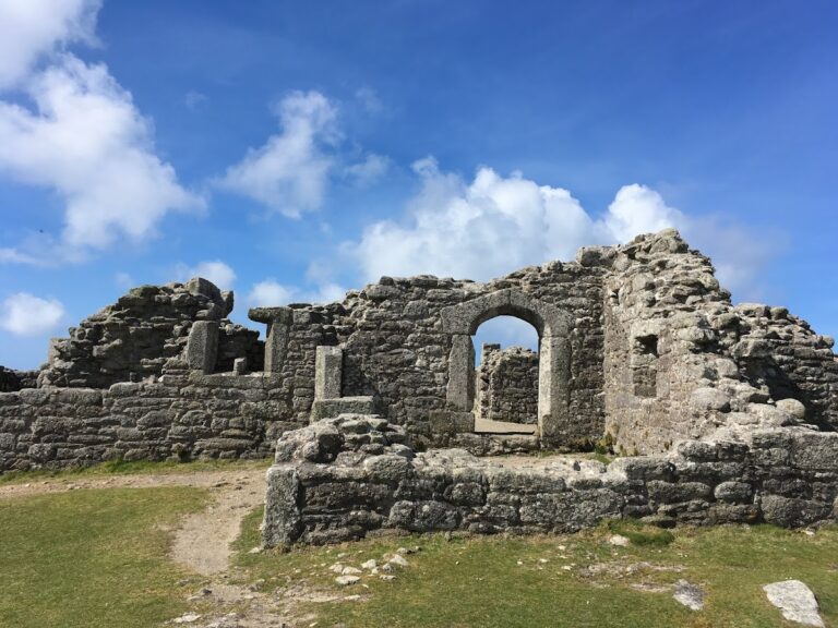
The best-preserved remains form the south-west side of the fort. Two granite-built bastions are joined by a curtain wall, meaning a connecting defensive wall between projecting fortifications. The bastions and their orillons measure about 21 metres by 5 metres and stand approximately 2.3 metres high. The connecting wall is 27 metres long and 1.7 metres high.
Granite blocks and rubble make up the surviving walls. In several places, exterior blocks have been removed, exposing the rubble core inside. The remaining south-west defences are nevertheless described as well preserved.
Defensive ditch and standing stone
An unfinished ditch follows the outside of the fort. It measures approximately 25 metres in length, 8 metres in width, and 1.2 metres in depth, providing physical evidence of the defensive works that accompanied the planned walls.
A prehistoric standing stone lies just north of Harry’s Walls. It was later used as a navigational marker at sea, and a modern navigational aid now stands beside it.
Nearby sites