Greifenstein Castle Ruins: A Hilltop Castle in Germany


Site at a Glance
- Rating
- 4.4
- Popularity
- Very Low
- Country
- Germany
- Primary era
- Medieval
- Eras represented
- Medieval
- Civilizations
- Holy Roman Empire
- Site type
- Military
- Remains
- Castle
On this page12 sections
History
Greifenstein Castle Ruins are the remains of a medieval hilltop castle in Germany, on the Schlossberg near Großtöpfer in Thuringia’s Eichsfeld district. The castle was built around 1397, when the area was shaped by the territorial ambitions of the Landgraves of Thuringia and the Counts of Henneberg. Its builders and early knights are unknown, but the castle later became a center of noble, clerical, ducal, and princely authority.
Foundation and Destruction in 1397
The castle first appears in records in 1397, the same year in which citizens from Erfurt, Mühlhausen, and Nordhausen attacked it. Duke Otto of Brunswick led the assault. The castle was stormed and destroyed because its occupants were accused of robber-knight activities, meaning raids, extortion, or other predatory actions carried out from a fortified residence.
The earlier Crafto de Grifenstein, mentioned in 1283, probably belonged to another castle with the same name. The castle and its surrounding administrative district probably belonged to the Landgraves of Thuringia and the Counts of Henneberg, who pledged or sold such possessions to different knightly families. This pattern of changing control helped place Greifenstein within the shifting territorial politics of central Germany.
Rebuilding and Mainz Administration
After its destruction, Greifenstein was rebuilt and came into the possession of the Electorate of Mainz. This was the territory governed by the archbishop of Mainz, who also held the rank of an elector in the Holy Roman Empire. In 1461, the castle was pledged to Duke Wilhelm of Saxony and then to the Lords of Bültzingslöwen, who held it in pledge until 1539.
The chapel and its administration also appear in the records of this period. In 1464, Hermann Diede of Fürstenstein was associated with debts to the Lords of Hanstein that had helped finance the construction of an altar in the Greifenstein chapel. In the same year, Hermann Dythe was recorded among the castle’s officials. Elector Albrecht reacquired Greifenstein for Mainz in 1539, paying 600 gulden.
Under Mainz, the former castle territory became the administrative district of Greifenstein. Its jurisdiction included Kella, Pfaffschwende, Rüstungen, Sickerode, Dieterode, Wiesenfeld, Hessel, and the noble estate of Volkerode with Goburg, along with several settlements that later disappeared. The Lords of Weberstedt, who owned nearby Wiesenfeld until 1380 and lived there in a fortified residential building, were also connected with the area’s administrative history.
Courts, Officials, and Decline
Greifenstein served more than a military purpose. A criminal court site called a Sponstätte was recorded in the late sixteenth century, and the castle itself probably also functioned as a court site. A map made around 1590 shows a gallows between Greifenstein and Pfaffschwende. Separate courts operated at Dieterode and Pfaffschwende.
Several officials are associated with the district and castle. Herman von Ershausen held office in 1400, Hermann Dythe was recorded in 1464, and Rudolf von Bültzingslöwen served as district official in 1521. Klaus Wagner held office from 1566 to 1584, followed by Philipp Falk from 1592 to 1617. A Mainz bailiff, an official responsible for territorial administration and justice, still lived at the castle in 1661.
Greifenstein lost its strategic importance after border disputes between the Electorate of Mainz and the Landgraviate of Hesse-Kassel were settled in 1583. The castle then declined gradually and was abandoned during the seventeenth century. The Mainz district of Greifenstein was subsequently administered with the neighboring district of Bischofstein.
The Lower Estate and the Border Zone
A farmstead called Wettirg appears on a late-sixteenth-century map below the summit, beside the road from Kella to Töpfer. It probably supplied food to the castle’s inhabitants. By the early eighteenth century it was known as Wettig, a name that may have preserved part of the vanished settlement of Wetche, which had included nine farms and related agricultural holdings.
The farmstead was rebuilt as an estate in the mid-eighteenth century, and a forester’s house was later added nearby. The estate became a Prussian domain in 1803 before being leased and then transferred into private ownership in 1841. The noble Keudell family of Schwebda purchased it in 1914. After its expropriation in autumn 1945, the land was distributed to new farmers and later incorporated into the Kella agricultural cooperative. In the late 1960s, East German authorities decided to demolish the estate and forester’s house as part of border-security measures.
During the period of German division, the castle ruin stood within the restricted border zone. Local residents could not reach it until 1989. A field called the Kirchhofsacker remained known at the foot of the hill until the beginning of the twentieth century. The name raises the possibility that a church once stood there, although this remains uncertain.
Remains
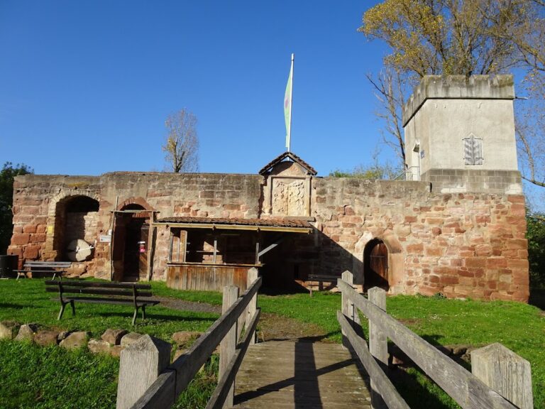
Greifenstein stood on the 442.5-metre-high Schlossberg in the southern Eichsfeld, about 2 kilometres west of Großtöpfer and 2 kilometres east of Kella, near the border with Hesse. The fortification used simple sandstone ashlar masonry, with little architectural ornament. Its surviving remains consist of the central tower stump, fragments of cellar vaults, sections of wall, ramparts, and ditches.
Castle Fortifications
Keep
The most substantial surviving feature is the roughly 5-metre-high stump of the circular keep. It measures 10 metres in diameter. This principal fortified tower served as a defensive stronghold rather than primarily as a permanent residence. Its remaining masonry provides the clearest indication of the castle’s scale and sandstone construction.
Walls, Ramparts, and Ditches
Fragments of the surrounding walls survive together with ramparts and ditches. Remnants of cellar vaults belong to the castle’s internal structures. These features preserve parts of the defensive enclosure and the lower architectural spaces, although the fortification now survives in a fragmentary condition.
Features Below the Summit
Kirchhofsacker
The area at the foot of the hill was known as the Kirchhofsacker. Its name suggests a connection with a former churchyard, but whether a church stood there is uncertain. The field name remained in use until the beginning of the twentieth century and forms part of the historical landscape associated with the castle.
Wettig Farmstead
The associated farmstead lay below the summit along the route between Kella and Töpfer. It was known as Wettirg in the late sixteenth century and as Wettig by the early eighteenth century. Its probable role was to supply the castle’s inhabitants with food. The farmstead was later rebuilt as an estate, with a forester’s house added nearby, before both buildings were demolished during border-security measures in the late 1960s.
Nearby sites