Tilbury Fort: A Thames Estuary Artillery Fortress in England


Site at a Glance
- Rating
- 4.4
- Popularity
- Medium
- Country
- United Kingdom
- Primary era
- Early Modern
- External website
- Open
- Eras represented
- Early Modern, Modern
- Civilizations
- British, English
- Site type
- Military
- Remains
- Fort
On this page25 sections
History
Tilbury Fort is a historic artillery fortress in the United Kingdom, on the north bank of the River Thames in Essex. Its present core was reconstructed between 1670 and 1685 in a predominantly Dutch style, although the site began as a Tudor blockhouse built under Henry VIII in 1539. Positioned where the Thames estuary narrows, it controlled river traffic and the approaches towards London, the royal dockyards at Deptford and Woolwich, the Long Ferry into London, and the Cross Ferry across the river.
Tudor origins
Temporary defenses had occupied Tilbury in the fourteenth and fifteenth centuries, but their form is not known. The first permanent fortification was built in 1539 as part of Henry VIII’s national coastal-defense program. International tensions followed the king’s break with the papacy and the annulment of his marriage, while the possibility of invasion by France and the Holy Roman Empire encouraged the construction of new defenses.
Henry’s plan created a mutually supporting chain of blockhouses at Gravesend, Milton, and Higham on the south bank, together with West and East Tilbury on the north bank. West Tilbury Blockhouse stood on the site of a hermitage dissolved by the Crown in 1536. It was commanded by Captain Francis Grant and his deputy, and its small garrison consisted of a porter, two soldiers, and four gunners. The blockhouse held as many as five artillery pieces, including a demi-cannon and sakers, but the guns were ordered to be removed in 1553 after the immediate invasion threat had passed.
The Armada and the seventeenth century
Tilbury was hastily strengthened during the Spanish Armada crisis of 1588, when Spain sent a fleet and invasion force against England. Robert Dudley, Earl of Leicester, directed the emergency improvements. Queen Elizabeth I arrived by barge on 8 August and went on to the nearby army camp, where she addressed the assembled forces.
In the year after the Armada, the Italian engineer Federigo Giambelli probably added two concentric earthwork ramparts, ditches, and a palisade. A boom stretched across the Thames to Gravesend, creating a barrier for river traffic. Early seventeenth-century surveys also noted flooding from the tides and uncontrolled entry by ferry passengers and animals.
During the English Civil War, the conflict between supporters of Charles I and Parliament, Parliament controlled Tilbury and Gravesend. A military governor regulated traffic entering London and searched for spies. Tilbury saw no fighting during the war, but it continued in service during the interregnum, the period of republican rule between Charles I’s execution and the Restoration of Charles II. In 1651 its garrison comprised three officers and sixty-six men.
Restoration reconstruction
After Charles II returned to the throne in 1660, the Crown renewed the coastal-defense program. The Dutch raid up the Thames in June 1667 exposed weaknesses in the river defenses. Although Tilbury itself had only two guns ready for action during the raid, the government later mounted eighty guns at Tilbury and Gravesend.
Charles II commissioned Sir Bernard de Gomme, a Dutch military engineer and the king’s Chief Engineer, to redesign Tilbury. A design approved in 1670 led to reconstruction from that year until completion in 1685. Skilled contractors worked alongside large groups of pressed laborers, with up to 256 people employed in 1671. Around 3,000 timber piles were brought from Norway to support the foundations in the marshy ground. A planned riverside bastion was cancelled in 1681, partly to reduce costs.
The reconstruction incorporated the earlier Tudor blockhouse but replaced the Elizabethan earthworks. After 1694, wooden riverside gun platforms were progressively replaced with more durable stone versions. The rebuilt fortress became one of Britain’s most powerful forts by the beginning of the eighteenth century.
Eighteenth-century military use
Tilbury’s duties expanded beyond direct defense of the river. From 1716, the Board of Ordnance, the government body responsible for artillery, military stores, and related installations, used the fort as a gunpowder depot. It also served as a transit depot for soldiers. After the Jacobite rising of 1745, 268 Highland prisoners of war were confined there in the gunpowder magazines. Forty-five died of typhus before the survivors were transferred to London for trial.
The marshy setting and poor communications made life at the fort unhealthy. The garrison depended on collected rainwater and a spring, while malaria recurred. In 1873, thirty-four of the 103 soldiers stationed there were admitted to hospital with malaria. An Army Medical Report the following year called the fort unhealthy and stated that troops were consequently moved every six months.
A sutler, a civilian who sold provisions to soldiers, established a house inside the southern entrance. The sutler grew vegetables in the south-west bastion and held an effective monopoly on food sales. Officers’ and enlisted men’s barracks were rebuilt in 1772, although officers often lived at Gravesend. A reported cricket match in 1776 between men from the Kent and Essex sides of the Thames ended in violence involving firearms, but the accuracy of the newspaper account is uncertain.
Napoleonic and Victorian defenses
Fears of a French attack during the American Revolutionary War led to a practice assault on Tilbury by 5,000 soldiers in 1780. By then fewer than sixty guns remained, many in poor condition. Thomas Hyde Page’s inspection in 1788 found the river defenses seriously inadequate, leading to the construction of a new south-east battery and the nearby New Tavern Fort.
During the French Revolutionary and Napoleonic Wars, additional river batteries were built and Tilbury’s guns received new traversing platforms. The Gravesend Volunteer Artillery was formed to man defenses on both sides of the Thames. During the invasion scare of 1803, the Royal Trinity House Volunteer Artillery operated ten armed hulks arranged as a barrier across the river at Tilbury.
Steamships, rifled artillery, armored warships, and turret-mounted weapons reduced the effectiveness of the older fort during the nineteenth century. In 1860, the Royal Commission on the Defence of the United Kingdom, a government inquiry into national and coastal defenses, recommended that newer forts be built farther downstream and that Tilbury become a second line of defense.
Strengthening began in 1868 under Captain Charles Gordon. The west, north-east, and east bastions and the south-east curtain wall were adapted for thirteen rifled muzzle-loading guns, which were loaded through the barrel but used spiral grooves to improve the flight of their projectiles. Brick walls, earthworks, and iron shields protected the new positions. The original 7-inch guns were replaced by 9-inch weapons by 1888, together with a heavier 11-inch gun. The Tudor blockhouse was demolished to make room for this artillery.
Depot, wartime station, and preservation
By the end of the nineteenth century, further advances in naval and defensive technology had made Tilbury largely obsolete as a defensive fortification. From 1889 it served as a strategic depot and mobilization center for the London Defence Scheme, a plan for organizing the capital’s defenses. It supported a mobile strike force and stored military materiel.
Four quick-firing 12-pounder guns were installed in 1903, followed by two 6-inch breech-loading guns in 1904. The government removed the artillery in 1905 after judging that the Royal Navy and forts farther downstream adequately protected London, although machine guns remained.
During the First World War, Tilbury functioned as a mobilization store, accommodated as many as 300 transit soldiers, supplied camps at Purfleet and Belhus Mansion, and stored munitions. A remount depot, a facility for receiving and supplying army horses, was built west of the fort. A pontoon bridge across the Thames supported troop movements. The fort first housed the 2nd Battalion of the Royal Dublin Fusiliers, an infantry regiment, and later reserve units and the headquarters of several infantry battalions until 1917.
Electric lighting, a narrow-gauge railway, and a steam crane on the quay were added during the war. After Zeppelin raids in June 1915, anti-aircraft guns and searchlights were installed. Tilbury took part in bringing down the German naval Zeppelin L15, although the identity of the local site that fired the shell which destroyed it remains disputed.
During the Second World War, Tilbury initially housed an improvised anti-aircraft operations room controlling the Thames and Medway (North) Gun Zone from 1939 to 1940. Trenches were dug around the fort against airborne attack. Bombing damaged the enlisted barracks, facilities block, and probably the sutler’s house, all of which were demolished after the war.
The fort was demobilized in 1950, when the Ministry of Works assumed control. Many modern military additions were removed during the 1950s, followed by restoration in the 1970s. The site opened to the public in the early 1980s and is now controlled and operated by English Heritage. It became a scheduled monument on 18 January 1973, while the officers’ barracks is separately listed at Grade II*. The late seventeenth-century defenses have been described as England’s most spectacular example of a late seventeenth-century fort and the best surviving example of their type in Britain.
Remains
Overall layout and water defenses
Tilbury’s surviving core is a large, predominantly Dutch-style, five-sided defensive work with four angular bastions, brick-faced earthworks, an outer curtain wall, and two water-filled moats. The design allowed the guns to engage warships on the Thames while also resisting an assault from land. The inner moat is about 50 metres wide and relatively shallow. Both moats are fed by the river and separated by defensive ramparts, while the surrounding marshland could be flooded as an additional obstacle. Timber piles repeatedly strengthened the moat banks against erosion.
The fortress was built on unstable marshy ground. About 3,000 timber piles supported the late seventeenth-century foundations, while chalk and earth raised the interior above the marshes and flooding. The moats, sluice, ramparts, and earlier palisades formed a connected system that managed water as well as strengthening the defenses.
Outer defenses and entrance works
North entrance
Entry from the north passes through a triangular redan, a projecting triangular defensive work, and an associated redoubt, a small enclosed fortification. A causeway connects the redan with the outer defenses, which contain ramparts and a covered way around the defensive line. Bastions occupy the north-west and north-east corners. Triangular spurs formerly equipped with guns project from the west and east sides, with infantry assembly points on their inner faces.
Ravelin and bridges
A replica wooden bridge crosses the water from the outer defenses to an island ravelin, an outwork placed beyond the main fortification to protect an entrance. A second replica bridge connects the ravelin to the inner defenses and is protected by two drawbridges. The ravelin shielded the inner entrance from direct artillery fire and allowed defenders to fire against troops who breached the outer line.
Riverside gun lines
The riverside outer defenses contain the West and East Lines, eighteenth-century gun positions facing the Thames. Erosion and silting have affected these works. Twelve of the original fourteen positions survive on the West Line, while one survives on the East Line. Between them lies a quay designed for deliveries from the river. Remains of the First World War narrow-gauge railway survive on the quay, and a sluice gate in the south-west corner controlled the moat water and allowed the moats to be drained when they began to freeze.
World’s End
The World’s End pub stands west of the outer defenses. Built in 1788, it was originally the local ferry house.
Inner fortress
Parade ground
The inner defenses form a pentagon around a central parade ground covering about 2.5 acres, or 1 hectare. The ground was raised with chalk and earth during the seventeenth and nineteenth centuries to protect the interior from marshes and flooding. Four large warehouses occupied much of the parade ground by the early twentieth century before later demolition.
Water Gate
The Water Gate provides entry from the south. Its late seventeenth-century, two-storey gatehouse has a monumental stone front carved with classical decoration and seventeenth-century weapons. An empty niche probably held a statue of Charles II. The building originally served as the master gunner’s house.
South-east defenses
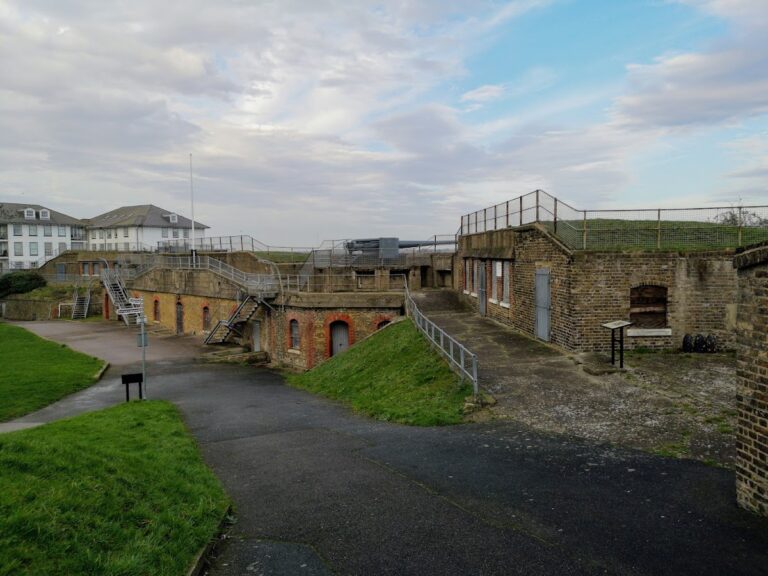
The south-east curtain wall and bastion were rebuilt at the beginning of the twentieth century for four quick-firing guns and two 6-inch guns. Tunnels connected the emplacements with an underground magazine. Four artillery pieces dating from 1898 to 1942 are displayed at the fort.
Officers’ quarters and stable
The officers’ quarters face the parade ground as a terrace of houses probably dating in their present form from the late eighteenth century. A stable at the northern end originally held the commandant’s horses. It now contains the Bernard Truss collection of military memorabilia.
North-east bastion
The north-east bastion was redesigned after 1868. It contains an earth-covered magazine and emplacements for 9-inch rifled muzzle-loading guns.
Gunpowder magazines
Two early eighteenth-century gunpowder magazines stand on the north side of the parade ground. A magazine was a secure military storehouse for powder and ammunition. The buildings were altered in the nineteenth century and constructed without iron, which could create sparks. Wood and copper were used instead. They are described as the only surviving examples of their type in Britain.
Landport Gate and Dead House
The Landport Gate lies behind the magazines. Above the passage leading into the fort’s interior stands a gatehouse known as the Dead House.
Former soldiers’ barracks
The soldiers’ barracks once stood opposite the officers’ quarters beyond the north-west bastion. They were demolished after the Second World War, leaving their foundations.
South-west magazine
The south-west magazine includes a covered magazine similar to the one in the north-east bastion.
Guardhouse and chapel
West of the Water Gate are the late seventeenth-century guardhouse and chapel. The chapel is among the oldest surviving places of worship within a British artillery fortress.
Nearby sites