Fort Boyard: A French Maritime Fortification in the Pertuis d’Antioche


Site at a Glance
- Rating
- 4.5
- Popularity
- Medium
- Country
- France
- Primary era
- Modern
- Eras represented
- Early Modern, Modern
- Civilizations
- French
- Site type
- Military
- Remains
- Fort
On this page20 sections
History
Fort Boyard is a nineteenth-century French maritime fortification on the Longe de Boyard sandbank between Île-d’Aix and Île d’Oléron. Its design followed Montalembert’s system of perpendicular fortification, which concentrated artillery in protected chambers within massive walls. The fort was intended to defend the Rochefort naval arsenal, the mouth of the Charente, its anchorage, and the port from the British fleet.
The First Proposals
The need for a fort on the sandbank became apparent after the Rochefort arsenal was completed in 1666. Existing coastal batteries could not cover the roughly 5.3-kilometre passage between the islands, because artillery of the period reached only about 1,500 metres. Vauban, France’s leading seventeenth-century military engineer under Louis XIV, rejected the proposal as impracticable. He reportedly told the king that building a fortress there would be more difficult than grasping the moon with one’s teeth.
A new project received approval in 1801 from Bonaparte, then First Consul. The proposed fort measured approximately 80 by 40 metres and used Montalembert’s approach rather than the projecting bastions characteristic of earlier fortresses. Its guns would fire from casemates, protected chambers built into the thickness of the walls.
Napoleonic Construction
Preparatory work began in 1803 on Île d’Oléron, where a camp, workshops, and storage areas were established. The camp developed into Boyardville. Marine construction started in 1804, but the undertaking faced unstable sand, shortages of labour and shipping, storms, financial problems, and interruptions connected with the British fleet.
On 11 May 1804, workers placed a seven-cubic-metre block of rock for the foundations beneath an iron beacon. Explosives had been used to quarry the stone at Coudepont on Île-d’Aix, and barges carried it to the sandbank. About 11,000 cubic metres of rock had been deposited by the winter of 1804–1805, and the total reached 26,000 cubic metres by the end of 1805.
The early foundations repeatedly failed. Winter storms in 1805–1806 displaced the first blocks, while three-cubic-metre blocks laid in 1806 were swept away during the following winter. In 1807, larger blocks were joined with hydraulic lime and iron clamps. Even so, about 60,000 cubic metres of rock sank more than a metre into the sand. Further storms damaged the foundations, and the suspension of construction credits caused unrest among unpaid workers.
Napoleon visited the site in August 1808 and reduced the planned fort to approximately 40 by 20 metres. Work resumed in 1809 but stopped after British naval operations in April, including the Battle of the Basque Roads, when fireships attacked the French squadron near the Charente estuary. Construction was definitively suspended in June 1809.
Completion under Louis-Philippe
The project was revived during the reign of Louis-Philippe I, the constitutional monarch of France, when renewed tensions with Britain brought new funding and a smaller design. Construction resumed in 1841, after the earlier rock foundations had settled and stabilised. The foundations were completed in 1848, and military engineers took over the superstructure in 1849.
Successive stages of the fort were completed in 1852, 1854, and 1857. The first cannons were installed in 1859. The final works, including a landing harbour and a protective spur, continued until 1866, and the completion record was signed on 6 February of that year. By then, improvements in artillery range allowed the coastal batteries to cover the passage between the islands. Fort Boyard consequently had limited military use and acquired the local nickname “the fort of the useless.”
Prison and Tide-Gauge Station
The completed fort could house 250 men for two months without contact with the mainland. Its later military history included use as a prison for Prussian soldiers captured during the Franco-Prussian War of 1870. It subsequently held political prisoners from the Paris Commune, the short-lived revolutionary municipal government that ruled Paris in 1871. Among them were the journalist and political figure Henri Rochefort and the political activist Paschal Grousset.
From 1873 to 1919, Fort Boyard also contained a tide-gauge observatory. A tide gauge, or mareograph, records changes in sea level. The station had been transferred from Fort Énet, where its measuring well repeatedly filled with silt, and the first sea-level observations at Fort Boyard were made on 11 August 1873.
Abandonment and Preservation
The army relinquished the fort in 1913, after which its cannons were removed and sold as scrap. During the Second World War, German forces used the building as a target for training exercises, causing damage. The fort then remained abandoned for about 80 years. Wind, sea spray, storms, seabirds, vegetation, and pillaging contributed to its deterioration. A small earthquake on 20 July 1958 damaged parts of the coast, although surveys reported that the fort’s cracks had not changed in comparison with earlier inspections.
The Ministry of Defence transferred Fort Boyard to the state property administration on 4 October 1961. It was auctioned on 28 May 1962, with a starting price of 7,500 francs, and purchased for 28,000 francs by André Aerts. He did not have the means to restore it. An attempted sale in 1979 at 1.2 million francs attracted no buyer.
Fort Boyard had been listed as a historic monument on 1 February 1950, a status requiring approval from the regional historic-monuments authorities before alterations. In 1988, Aerts sold the fort for 1.5 million francs to Jacques Antoine’s television-production company. The company transferred it immediately to the department of Charente-Maritime for one symbolic franc, while the department accepted responsibility for rehabilitation and the company received exclusive television-production rights. The department has owned the fort since 1989.
Television Era
Jacques Antoine first encountered Fort Boyard in the 1967 film Les Aventuriers. The fort had also appeared in the 1980 pilot of La Chasse au trésor and in a 1981 episode in which contestants searched for a Napoleonic snuffbox. Antoine later selected it for a television adventure programme initially titled Les Clés de Fort Boyard.
Rehabilitation began in 1989. Workers removed rubble, cannonballs, wild grasses, and approximately 50 centimetres of guano, clearing about 700 cubic metres of waste. Rooms were adapted for television production, and the first programme was filmed in 1990. It was renamed Fort Boyard the following year. Since 1990, the fort has been the filming location of the internationally distributed game show, which has become its principal modern identity and has generated economic returns used to help finance maintenance.
Remains
Setting and Structure
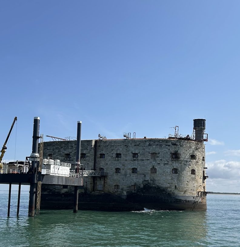
Fort Boyard is an oblong stone fort standing on a formerly submerged sandbank. The artificial island is exposed at low tide and lies approximately 2,900 metres from Île-d’Aix and 2,400 metres from Île d’Oléron. The fort measures 68 metres along its main axis and 31 metres across. Its ground area is approximately 2,065 square metres, and its total floor area is about 2,689 square metres.
The enclosing walls rise about 20 metres above the foundations. Three principal storeys are arranged around an interior courtyard measuring approximately 43 metres by 12 metres, with an area of about 565 square metres. Balconies and circulation galleries connect the levels, which contain more than 70 cells. The ground floor was completed in 1852 at roughly 3.50 metres above the reference level, the first floor in 1854 at about 8.80 metres, and the second floor in 1857 at approximately 13.90 metres. The terrace and upper crown reached about 19 metres, while the lookout tower rose to around 27 metres above the highest waters.
Foundations and Stonework
The submerged outer face of the foundations is built from granite blocks brought from the Cotentin. The original foundation rock was quarried on Île-d’Aix. When construction resumed, prefabricated lime caissons were made at the Île-d’Oléron base and installed at low tide with a steam crane mounted on a pontoon. The superstructure uses dressed limestone from the quarries of Crazannes, selected for resistance to frost and erosion and transported by boat along the Charente.
Military Interior
The fort was designed with 74 embrasures, openings in the walls through which guns could fire. The artillery was housed in casemates within the wall thickness, while the military installation also included artillery platforms, powder magazines, food stores, cisterns, kitchens, accommodation, and an infirmary.
Storeys and Courtyard
The ground floor contained the cisterns, powder magazines, food stores, and kitchens. Officers and employees were accommodated on the first floor. The second floor provided additional accommodation, the commander’s quarters, and an infirmary. During the television adaptation, openings received windows, doors, and shutters, and a raised circulation platform was built along both sides of the courtyard at first-floor level to connect the cells.
Artillery Platforms and Upper Crown
The artillery platforms were dismantled and restored in 1996. In 1998 and 1999, the stones of the upper crown and terrace floor were removed, cleaned, and relaid. The facade walls were cleaned, their joints inspected and repaired, cracks were treated, and the terrace waterproofing was renewed. The former clock position was also repaired in 1998.
Entrances and Landing Works
Western Entrance
The western entrance is reached by a large granite staircase. Shallow water, waves, and the slippery surface made this stairway inadequate for maritime access, particularly at low tide or during storms. The historic stone landing works were later destroyed or lost, leaving the fort exposed to waves and making the staircase unusable as its sole access route.
Harbour and Protective Spur
Temporary landing piers supported construction in 1850 and were rebuilt in 1852 after storms destroyed them. From 1859, a sheltered landing harbour, or barachois, was built to the southeast below the lookout tower, while a protective breakwater was planned to the northwest. The first breakwater design called for a chevron-shaped wall about 20 metres from the fort, using blocks of approximately 20 and 26 cubic metres. Construction difficulties led to its abandonment. In 1864, it was replaced by a triangular rocky spur attached to the northwestern end of the fort. A protective dyke was added to the harbour, and its two piers, each 22 metres long and 4 metres wide, were extended by 8 metres.
Modern Access Installations
A temporary offshore access platform and metal gangway were installed in 1989 about 25 metres from the southwest side. A crane-operated transfer system connected the platform to the entrance and supplied water, equipment, and a generator. The original SEERS 3 platform was weakened by storms and corrosion and was replaced in March 2015 by a larger platform named Banjaert, after the earlier name of the sandbank. In 2016, a first-floor gun opening above the main entrance was enlarged and fitted with a metal balcony to provide a secondary access point during heavy swell.
Adaptation and Conservation
Television Installations
A wooden helicopter landing platform was installed on the northeastern part of the terrace in 1991 and rebuilt in April 2018 in the same position and to the same design. Television scenery, including the Treasure Room and the lookout area, was installed in 1990. The cells now contain game mechanisms and technical equipment associated with filming rather than the military stores and accommodation for which the rooms were built.
Courtyard and Foundations
The interior courtyard was rebuilt during the winter of 2003–2004. In 2005, cracked sections of the southern foundations were filled by injecting mortar grout and special concrete. Damaged stone blocks in the courtyard walls and arcade pillars were replaced, and the joints were renewed.
The name Fort Boyard comes from the Longe de Boyard sandbank. An earlier explanation linked it to the seventeenth-century Dutch chart form Banjaert Hollandis, but later research favoured a connection with the local term boyart, referring to a wooden component of a saltworks sluice.