Chellah: An Ancient Roman City and Marinid Royal Necropolis in Morocco


Site at a Glance
- Rating
- 4.5
- Popularity
- Medium
- Country
- Morocco
- Primary era
- Medieval
- External website
- Open
- Eras represented
- Classical, Medieval, Modern
- Civilizations
- Alaouite, Kingdom of Mauretania, Marinid, Roman
- Site type
- City
On this page24 sections
History
Chellah is an archaeological site in Rabat, Morocco, where a Mauretanian and Roman urban settlement developed into a Marinid royal necropolis. It occupies the south bank of the Bou Regreg estuary, on the site of ancient Sala, whose history extends from debated Phoenician or Punic contacts to the Roman period and the Islamic Middle Ages. The surviving remains bring together a former port city, Roman civic monuments, and a medieval religious and funerary complex.
Mauretanian Sala
The earliest possible Phoenician presence at Chellah remains debated. Bowl fragments dating from the seventh and early sixth centuries BC may have reached the site through trade, while Neo-Punic objects from the third century BC point to a small trading post. The settlement was known as Shalat, a name apparently derived from the Punic word for “rock.” Before Roman annexation, it belonged to the Mauretanian Kingdom, an ancient Berber kingdom in North Africa.
Under Mauretania’s last two rulers, Juba II and Ptolemy, the kingdom became a Roman client state. Objects associated with both kings were found at Chellah. During this period, Sala developed as a prosperous commercial center linked to trade across North Africa and the Mediterranean. Its position beside the estuary supported maritime activity as well as connections with inland routes.
Roman Sala Colonia
Roman influence was established by the later centuries BC. After Ptolemy’s death in AD 40, Rome annexed the region and incorporated it into Mauretania Tingitana, the Roman province created from the kingdom’s western territory. The Romans developed Sala Colonia as a substantial urban and port settlement with commercial, cultural, administrative, and religious functions. Inscriptions show that it held the status of a municipium, a Roman city with recognized civic standing, by about the middle of the second century AD.
Sala Colonia joined the provincial road network through Iulia Constantia Zilil and Lixus, and may also have been connected by a southern route toward Anfa, the site of present-day Casablanca. Its port served as a stopping place for Roman commercial vessels traveling southwest toward Anfa and Insula Purpuraria, now known as Mogador Island.
Roman legions later withdrew toward Tingis and Septem, but Sala remained connected with the Roman world. A Roman military unit may have stayed at the settlement until the end of the fifth century. Some major monuments were abandoned during this period, while Visigothic, Byzantine, and Christian material indicates continuing contacts with Roman Europe and North Africa between the fourth and sixth centuries.
Abandonment and Medieval Reoccupation
Sala began to be abandoned in the fifth century and was largely ruined by the arrival of Muslim Arabs in the seventh century. By the tenth century, the area had been reoccupied and a ribat, a fortified religious establishment, was recorded there. The new town of Salā, present-day Salé, was founded on the opposite bank around 1030. Later Almoravid and Almohad activity concentrated on other fortified settlements and on the royal city that developed into Rabat.
The Marinid Necropolis
During the Marinid period, when a Berber Muslim dynasty ruled Morocco from the thirteenth to the fifteenth century, the former site of Sala was redeveloped as a royal dynastic necropolis. The first Marinid construction and royal burial took place in 1284–1285, when Sultan Abu Yusuf Yaqub selected the site for the burial of his wife, Umm al-Izz, and built a small mosque beside her tomb. Abu Yusuf Yaqub was buried there in 1286. His son Abu Yaqub Yusuf followed in 1307, and Abu Thabit Amir was buried at Chellah in 1308.
The main building phase took place under Abu Said Uthman II and his son Abu al-Hasan. Abu Said enclosed the area with walls and began the principal gate, which Abu al-Hasan completed in July 1339. Abu Said’s burial place remains uncertain. Some traditions place him at Chellah, while the historian Ibn Khaldun stated that he was buried in Fez. Abu al-Hasan’s wife, Shams al-Duha, was buried at the necropolis in 1349, and Abu al-Hasan himself was buried there after his death in exile in 1351.
Abu al-Hasan’s son Abu Inan may have completed the mausoleum and may also have built or finished the religious school and minaret. He established a waqf, a charitable endowment supporting a religious or public institution, for the complex. Abu al-Hasan was the last Marinid sultan buried at Chellah, although princes and other members of the dynasty continued to be buried there occasionally.
Between 1360 and 1363, the Nasrid vizier Ibn al-Khatib visited the necropolis and described richly decorated tombs and a large fragment of kiswah, a cloth covering, placed over Abu al-Hasan’s tomb. The complex declined after the Marinid period. Ahmad al-Lihyani, a Marinid claimant to the throne active between 1417 and 1437, first pillaged it. The Wattasids, a later Moroccan ruling house, chose not to restore the necropolis, which then suffered further damage from earthquakes and looting.
The 1755 Lisbon earthquake caused many surviving structures to collapse. Alawi sultans later stationed soldiers at Chellah to deter further looting, but the Arab tribe Sabbaḥ occupied the enclosure in the late eighteenth century. The necropolis was looted again when Sultan Moulay Yazid removed the group in 1790.
Religious Traditions and Modern Interpretation
Chellah gained renewed local religious importance after Sufis began inhabiting the site and the madrasa was reused as a zawiya, a Sufi religious and educational center. Local pilgrims believed that visiting the site could substitute for the Hajj, the pilgrimage to Mecca, for people unable to make the journey. They performed tawaf, ritual circumambulation, around the madrasa’s mihrab, the prayer niche indicating the direction of Mecca.
Popular traditions connected the name Chellah with Lalla Chella, believed to have been the girl commemorated by the tomb of Shams al-Duha. Eels and turtles living in the pools were also attributed beneficial powers connected with fertility and childbirth. From the nineteenth century onward, the site became associated with the tombs of local saints and holy figures, including Sidi Lahcen al-Imam, Sidi Yahya Ben Younouss, Sidi Amer al-Masnaoui, Lalla Sanhaja, Lalla Regraga, and Lalla Chama. Sultan Moulay Abderrahmane Ben Hicham built the dome over Sidi Yahya Ben Younouss, and the principal entrance later became known locally as the gate of Sidi Yahya.
Charles Tissot identified the remains of the Roman city in the late nineteenth century, and a general plan of the ruins was prepared in 1901. Henri Basset and Évariste Lévi-Provençal investigated the Islamic remains in 1922 and published a major study of the Marinid necropolis, including epitaphs and descriptions of its architecture and artistic decoration. Their interpretations remain influential, although some of their hypotheses require further confirmation.
The first official archaeological excavations were carried out by the Antiquities Service of the French Protectorate. Under Jules Borély and Princess Khadija Riaz-Bey, work in 1929–1930 cleared vegetation from the ruined mosque and exposed much of the monumental Roman quarter. The excavations revealed the base of the triumphal arch, the Capitol, the Curia Ulpia, part of the decumanus maximus, the principal east–west street, and the medieval hammam, or bathhouse. Uthman Uthman Ismail conducted localized excavations in the Marinid khalwa, the secluded religious and funerary complex, during the 1950s and 1960s.
After Moroccan independence, Maurice Euzennat appointed Jean Boube to begin a new excavation campaign in 1958. Boube’s work continued intermittently into the 1990s, revealing major Roman and medieval structures, refining knowledge of Roman funerary practices, and contributing to the reconstruction of the ancient city’s urban plan. Chellah has been protected as a historic monument since the decree of 19 November 1920. Since 2012, it has formed one component of Rabat, Modern Capital and Historic City: A Shared Heritage, which is inscribed on the UNESCO World Heritage List.
Restoration and improvement work took place within the Rabat Ville Lumière, Capital of Moroccan Culture program launched in 2014 under King Mohammed VI. The Marinid complex was restored between 2019 and 2022. In 2023, excavations and archaeological soundings east and southeast of the Marinid wall revealed further information about the extent and limits of the Mauretanian and Roman city, its defensive system, and an ancient port district. The work identified a Roman-period port district dated to the first and second centuries AD and uncovered a life-sized headless statue of a female deity, the first discovery of its kind in Morocco since 1960.
Remains
Chellah contains a Roman monumental quarter and a smaller, roughly pentagonal Marinid enclosure. The Roman excavations cover approximately 1.2 hectares around the forum, while the medieval walls surround a religious and funerary complex in the southeast, a bathhouse near the far eastern corner, and a residential complex just inside the main gate. Because the ancient city occupied sloping ground, its buildings were arranged on artificial terraces, at least three of which remain visible. Streets followed a regular grid organized by the decumanus maximus and cardo maximus, the principal east–west and north–south streets.
Roman Monumental Quarter
The Roman city included paved streets, public squares, temples, baths, public buildings, houses, and fortifications. Latin inscriptions and architectural remains define the excavated area as a Roman urban district. The artisan quarter, cleared between 1962 and 1968, covers 1,261 square metres. It contains three olive presses, bakery installations, shops, and spaces apparently used privately by artisans or merchants. The olive-oil installation includes a circular pressing bed, or maie, where woven mats filled with olive paste were compressed. Oil flowed from the press into a settling basin, and the floor bears a distinctive grey-and-white bichrome mosaic.
Forum
The forum occupies the eastern end of the excavated area beside the decumanus maximus. It has a trapezoidal plan and was paved with large blue limestone slabs, preserved for approximately 20.60 metres from the podium. Built during works under Trajan, it was accessible only to Roman citizens and was closed by two monumental gates, whose substantial foundations survive. Bases for honorary inscriptions dedicated to emperors and major civic magistrates stood within the square.
Temple on the Northern Terrace
A structure on higher ground north of the forum has been identified as a temple with five cellae, the main sacred chambers of a temple. Its date remains debated. Jean Boube placed it in the middle of the first century BC and interpreted it as a Mauretanian building, while other archaeologists assigned it to the Roman period. More recent studies have again supported a pre-Roman date because of its construction techniques. Statues of Juba II and Ptolemy found there led Boube to suggest that the temple was originally dedicated to the two client kings.
Mauretanian Temple Complex
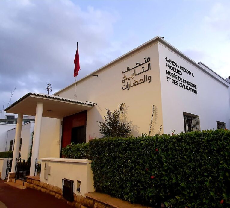
The earliest Mauretanian temple complex consists of three temples northwest of the forum. The principal temple stands on a terrace strengthened by a wall approximately 0.80 to 1 metre thick and 1.90 metres high. One interpretation dates it to the middle of the first century BC. It contains five rooms served by a rectangular gallery almost 4.10 metres wide. Its pronaos, the vestibule before a temple, measures 23.10 by 5 metres. Internal partitions form smaller northern chambers, while a niche in the rear of room IV measures approximately 2.56 metres wide and 1 metre deep. Two large Greek-marble statues were found there, including a portrait of Ptolemy that is now held by the Museum of History and Civilizations in Rabat.
Capitol
The Capitol, or Capitoline temple, stands northwest of the forum on two terraces and measures approximately 46 by 26 metres. Its western end has rounded or irregular corners. The lower level contains nine vaulted shops opening toward the decumanus maximus and the adjacent paved area. Above them, the temple stood on a podium and included a sacred chamber, a pronaos, a courtyard with an altar, a peribolos, or enclosing sacred precinct, a treasury chamber, and a Corinthian portico.
The portico followed the northeastern and southern sides and had 32 columns. White marble plaques faced the western part, and fragments remain. The upper structures above the shops have collapsed. Roman inscriptions indicate that the Capitol was built under Hadrian and may have been inaugurated around AD 120. C. Hosidius Severus, a local notable and equestrian military official, financed its construction and presented the temple to the city’s inhabitants.
Curia or Basilica
A poorly preserved building directly south of the Capitol, near the Marinid wall, has been provisionally identified as either the Curia Ulpia or a basilica. Probably contemporary with the Capitol, it measures approximately 32 by 19 metres. A large octagonal opening at its center, together with wall niches, belongs to an underground nymphaeum, a monumental fountain or water structure that once rose toward the building’s floor level.
Triumphal Arch
The remains of a three-bayed triumphal arch stand between the Capitol and the Curia or basilica. Three large cut blocks survive from its base and represent four former piers. The central opening measured approximately 4.30 metres, while the side openings measured 2.08 metres. The fourth pier and other elements were probably reused for lime production or medieval construction. The arch may date from Hadrian’s reign, although another attribution places it around the reign of Antoninus Pius.
Other Roman Structures
Two further structures identified as temples lie east of the Capitol. Roman bath remains occupy the eastern part of the site between the Marinid madrasa and the Islamic hammam. The excavated Roman cemetery contains numerous graves and burials, providing evidence for the typology and chronology of funerary practices at Sala. A broad paved area west of the forum may have been an additional forum, known in Roman terminology as a forum adiectum, or part of the decumanus maximus. Jean Boube dated it to the reigns of Trajan and Hadrian, although the sequence of changes in the forum area remains debated.
Marinid Enclosure and Religious Complex
The Marinid enclosure is smaller than the former Roman city and has an approximately pentagonal plan. Its rammed-earth walls, or pisé, contain three gates interrupted by defensive towers. The towers generally have square bases and three internal levels. Within the enclosure, the religious complex occupies the southeast, the hammam stands near the far eastern corner, and a residential complex lies just inside the principal entrance. The khalwa has an irregular plan created by additions made at different periods.
Main Gate
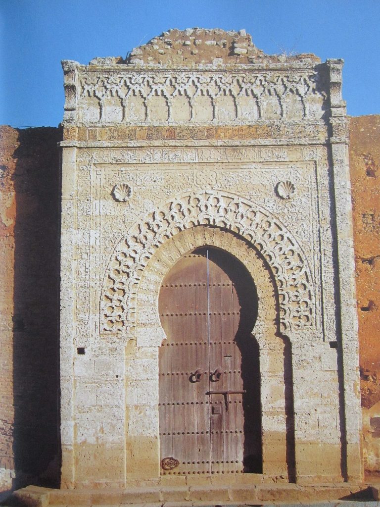
The monumental main gate stands in the northwest. Built of brick and cut stone, it has carved ornament, a pointed horseshoe arch, two polylobed-arch motifs, and foliate arabesques with carved shells. A rectangular alfiz, the frame around an arch, contains a Kufic inscription describing the gate’s construction. Its two flanking towers have prismatic or semi-octagonal lower bodies, square turrets, and muqarnas transitions, a three-dimensional ornament formed from tiered niches.
The passage turns through 90 degrees, while the inner facade facing the religious complex carries a simpler version of the exterior decoration. The gate was begun under Abu Said Uthman II and completed by Abu al-Hasan in July 1339. Its later local association with Sidi Yahya gave it the name gate of Sidi Yahya.
Mosque and Minaret
The mosque in the southwestern half of the khalwa is a hypostyle hall, meaning a hall supported by columns. Two rows of horseshoe arches divide it into three naves, and two additional rows set perpendicular to them define a central aisle leading to the mihrab on the southeastern wall. A small, partly ruined minaret stands at the southwest corner. Its square base and polylobed-arch windows remain visible, as does a nearby basin or well supplied by a local spring for ablution.
Rawda and Marinid Tombs
Behind the mosque’s qibla wall, the wall oriented toward Mecca, lies a rawda, or garden cemetery. It consists of a long enclosure containing at least four ruined mausoleums and additional graves. Three mausoleums adjoining the mosque’s rear wall are traditionally identified with the tombs of Abu Said and Shams al-Duha, among others. Each is a square qubba, a small domed or roofed mausoleum chamber, probably once covered by a dome or pyramidal tiled roof. The tombs are largely ruined and retain small fragments of their former decoration.
Abu al-Hasan’s Qubba
The qubba of Sultan Abu al-Hasan stands farther south against the perimeter wall. It is better preserved and more richly decorated than the other tombs in the complex. Its surviving stone walls carry elaborate low relief. On the interior rear wall, a double-arched niche is framed by an epigraphic frieze containing verses 30 and 31 of Surah XVI. Geometric and other calligraphic decoration surrounds the composition, while the lower walls retain zellij, glazed ceramic mosaic tilework. Three windows open above it.
The exterior contains Kufic and Naskhi inscription friezes, including verse 185 of Surah III and a dedication to Abu al-Hasan. Between them is a sebka panel, a geometric netlike pattern, above three blind polylobed arches supported by small colonettes. Carved shells, palmettes, arabesques, a repeated knotted-Kufic calligram, a small blind arcade, and a muqarnas cornice complete the surviving decoration.
Madrasa and Zawiya
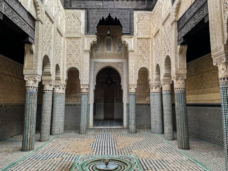
Most of the northeastern half of the khalwa is occupied by a building probably used as a madrasa, an institution for Islamic religious education, although two surviving inscriptions call it a zawiya. Its elongated rectangular courtyard contains a central rectangular pool and a small circular fountain basin at each end. A peristyle portico once surrounded the courtyard on marble columns, which no longer survive. Small rooms along the two long sides served as student sleeping quarters, and two staircases led to a probable upper floor with a similar arrangement.
The courtyard was paved and decorated with intricate zellij mosaics, portions of which remain. A doorway at its southeastern end leads to a rectangular prayer hall with a mihrab. A narrow passage surrounds and runs behind the niche and may have enabled pilgrims to circumambulate it. The gateway from the mosque’s northern forecourt to the madrasa has a horseshoe arch framed by an alfiz filled with geometric star patterns in brightly colored zellij. Its spandrels contain arabesque and polylobed-arch motifs. The decoration resembles that of the Sidi Boumediene complex in Tlemcen, suggesting that the same team of artisans may have worked on both gateways.
Madrasa Minaret
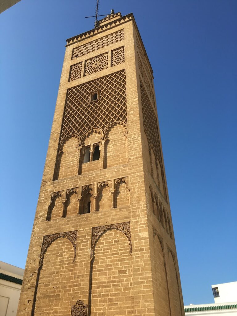
A preserved minaret rises at the northeastern corner of the madrasa. Approximately 15 metres high, it has a square shaft whose four facades are decorated with sebka panels above two blind polylobed arches containing small windows. Zellij fills the intervening decorative spaces. The minaret remains one of the identifiable vertical elements within the Marinid religious complex.
Marinid Hammam
The Marinid hammam has a roughly rectangular plan measuring 28.5 by 10.4 metres. Probably built between 1339 and 1358, it was restored in the twentieth century. Its rooms comprise an entrance changing room, a cold room, a warm room, and a hot room, followed by a furnace chamber that heated the baths and water through a hypocaust system. A small room near the changing area probably served as latrines.
Entry was through a gate at the western corner. The changing room had a square central space flanked by two rectangular galleries separated by arches on columns. The central space probably carried an ornate wooden vault, while the galleries had groin vaults. The cold and hot rooms also had groin vaults, and the larger warm room had two cloister vaults.
Later Shrines and Movable Remains
Several later shrines to Sufi mystics occupy the southern part of the necropolis. One contains the tomb of Sidi Yahya ibn Yunus, a mystic traditionally believed to have lived in the seventh century. Roman artifacts from Sala Colonia and Marinid objects from the necropolis are held at the Museum of History and Civilizations in Rabat.
The museum collection includes the marble tombstone of Abu Yaqub Yusuf, a reused slab originally from Roman Hispania Baetica. Its reverse bears a Roman inscription naming the provincial governor Aulus Caecina Tacitus, while the opposite face carries the Marinid funerary inscription. The slab had previously been reused in an Umayyad fountain in Cordoba, probably in the late tenth or early eleventh century, before being transported to North Africa and reused by the Marinids.
The collection also includes the marble maqabriyya tombstones of Abu al-Hasan and Shams al-Duha, carved as approximately triangular prisms with elaborate Arabic inscriptions, together with Marinid marble capitals. A large colony of storks nests in the trees of the site and on the minaret of the ruined zawiya.