Château de Châlus Maulmont: A Medieval Residence and Fortress in France


Site at a Glance
- Rating
- 4.3
- Popularity
- Very Low
- Country
- France
- Primary era
- Medieval
- External website
- Open
- Eras represented
- Medieval
- Civilizations
- Duchy of Aquitaine
- Site type
- Military
- Remains
- Castle
On this page8 sections
History
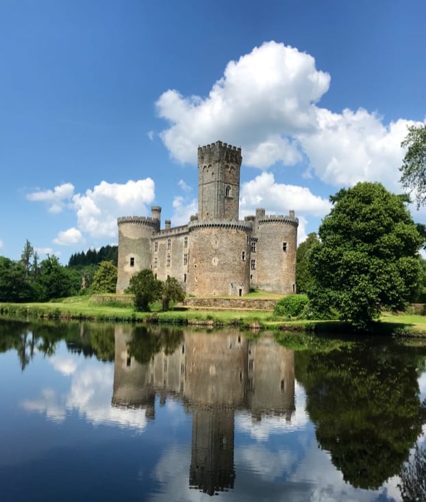
Château de Châlus Maulmont, also known as the Tour du Fort, is a thirteenth-century fortified residence and stronghold in Châlus, France. Géraud de Maulmont, a medieval noble administrator and counsellor to Marguerite de Bourgogne, Viscountess of Limoges, built it between 1275 and 1280 on land belonging to the lordship of Chalusset. The complex combined a prestigious residence with defensive works and formed a castrum, an enclosed fortified settlement with residential and administrative functions.
Construction and medieval role
The castle occupied the lower town of Châlus and was enclosed by walls. Its design reflected the dual purpose of the complex, providing Géraud de Maulmont with a substantial residence while also creating a defensible stronghold. The building campaign established the rectangular plan, residential building, and corner towers that shaped the site.
Destruction and later use
The residence was dismantled during the Wars of Religion, a series of sixteenth-century conflicts in France involving religious and political struggles. At the beginning of the French Revolution, the northwestern tower and the principal residential building remained intact. Between 1794 and 1799, local inhabitants heavily damaged them by taking stone from the castle for other construction.
The surviving portion later served as a prison. During the nineteenth century it was returned to Count de Bourbon Busset, whose younger branch became known as Bourbon-Châlus. In 1888, the count asked Jules Tixier, an archaeologist and architect from Limousin, to examine the structure in detail because the fortress was already considered at serious risk of collapse. The neglected roof structure of the main building fell in 1928.
Recent conservation and historical interpretation
The property returned to the Maulmont family in 1989 and is held by the Maulmont civil property company. Restoration began in 2005. The southeast tower collapsed on 20 March 1994, and its debris buried two occupied houses, a barn, and several vehicles, although nobody was killed or injured. The ruins were classified as historic monuments in 1981, while the land parcel was registered as a historic monument in 2020. In 2025, the site was selected for France’s heritage lottery, a national fundraising program for heritage preservation.
Until the middle of the twentieth century, local tradition and some postcards wrongly presented Châlus Maulmont as the castle from which the crossbow bolt that fatally wounded Richard the Lionheart was fired. Richard the Lionheart was Richard I, king of England from 1189 to 1199. The attack actually took place at Châlus-Chabrol in 1199, on the opposite side of the Tardoire valley.
Remains
The ruins stand on a hill about 370 metres above sea level on the left bank of the small Tardoire valley. Châlus-Chabrol occupies a rocky promontory on the opposite side. Château de Châlus Maulmont was built on banded leptynitic augen gneiss, a strongly metamorphosed rock with lens-shaped mineral structures. The rock belongs to the Lower Gneiss Nappe of Limousin, and its planar layering runs northward while dipping about 40 degrees to the east.
Plan and defensive enclosure
The original fortress had a rectangular plan surrounded by curtain walls, the continuous defensive walls enclosing a castle. The principal residential building measured approximately 36 by 13.60 metres. The castle now survives as wall remains and the damaged stump of the southeast tower. Parts of the curtain walls and the northeastern tower were taken for building stone during the French Revolution, leaving the surviving fabric closely tied to the later history of the site.
Principal residence
The main building, or logis, was two storeys high. Its southern and eastern sides contained large Gothic pointed-arch windows, medieval openings formed with pointed arches. Paired arches were surmounted by a rose window, a circular radiating window, and together these openings illuminated the principal living room on the upper floor. A staircase was built within the thickness of the masonry and led to the upper-floor halls.
Corner towers
Two towers occupied corner positions in the original design. One measured approximately 8.30 metres in diameter and reached 33 metres in height. The other measured about 7.10 metres in diameter, although its height is unknown. Both were entered from the upper floor through slightly pointed-arch doorways.
The southeast tower that collapsed in 1994 was approximately 27.6 metres high and 8.70 metres in diameter, with walls about 2.50 metres thick. Its remains now form the damaged tower stump within the surviving ruins.
Nearby sites