Aqueduc de Fontcouverte: Roman Water Supply for Saintes


Site at a Glance
- Rating
- 4.3
- Popularity
- Very Low
- Country
- France
- Primary era
- Classical
- Eras represented
- Classical
- Civilizations
- Roman
- Site type
- Infrastructure
- Remains
- Aqueduct
On this page15 sections
History
The Aqueduc de Fontcouverte in France formed part of the Roman water-supply network of Saintes, then known as Mediolanum Santonum. Built during the Roman period, its first phase probably began around AD 20 under the Julio-Claudian dynasty, the imperial family that ruled Rome from Augustus through Nero. The system supplied drinking water, the Saint-Vivien baths on the right bank, the Saint-Saloine baths on the left bank, and public fountains from the first to the fourth century.
Roman construction and expansion
The earliest aqueduct began at the Font Morillon spring in Fontcouverte. Its name is associated with this source and is explained as meaning “covered fountain.” The channel crossed the territories of Le Douhet, Vénérand, and Fontcouverte before reaching Saintes, following a general northeast-to-southwest axis. It crossed the Roman roads leading toward Aulnay and Cognac and continued toward the area of the present prison.
A second phase was probably constructed between approximately AD 70 and 120, when Saintes was expanding and its population was growing. This later aqueduct began at Grand Font in Le Douhet and passed through a separate sequence of places before reaching Font Morillon. There it ran alongside the first channel and effectively doubled its capacity. A branch from the Moulin spring at Vénérand joined the system between Chez Gautreau and Puy Gibaud. A third aqueduct was discovered above the first at Fontcouverte in 2010, although its date has not yet been established.
The first aqueduct was abandoned when the second came into service. The complete system ceased functioning during the fourth century. Limestone and alluvial deposits gradually narrowed the channels, and the flow had fallen to about half its original level by the end of the aqueducts’ operation. Estimated daily discharge at commissioning was 3,000 cubic metres from Font Morillon, 10,850 cubic metres from Grand Font, 8,525 cubic metres from the Moulin, and 19,375 cubic metres at the junction of the Le Douhet and Fontcouverte channels. Much of the masonry from the first aqueduct was later reused in other constructions.
Archaeological study and protection
Interest in the aqueducts of Saintes began in the early eighteenth century. Abel Triou reconstructed the complete route from 1968 and initiated the modern research programme. Bernard Bourgueil resumed excavations with volunteer teams in 2003. Archaeologist Jean-Louis Hillairet later identified the third aqueduct above the first at Fontcouverte, along with numerous filled-in wells.
In 2013, excavation uncovered the collapsed domed room at Font Morillon, where clearing work continued. Since 2012, the four municipalities concerned, together with regional heritage and archaeological organisations, have worked to make the aqueduct more accessible, renovated, and secure. The Fontcouverte section was classified as a French historic monument in 1990, while the Le Douhet section received the same protection in 1840.
Remains
The aqueduct extended for approximately 17 kilometres, descending from about 48 metres at its beginning to 24 metres at Saintes. Its channels, tunnels, bridges, and spring installations followed a gradient of less than 1 millimetre per metre, approximately 0.08 to 0.1 percent. This gentle fall allowed water to move by gravity across changing ground levels. The route alternated between rock-cut passages, open channels, and bridges, adapting the system to the landscape.
Sources and water channels
Font Morillon
At Font Morillon, the spring was gathered in a domed chamber cut into the rock before entering the aqueduct. Its retention basin formed a semicircle approximately 3 metres in diameter. A washhouse stands a few metres from the spring, although this structure dates from approximately the eighteenth or nineteenth century and therefore belongs to a much later phase than the Roman water system.
Grand Font and the Moulin
The second aqueduct began at Grand Font, near Chez Pérot and Le Roc in Le Douhet. Its route passed the castle, Le Ruisseau, Les Fontaines, La Foucherie, Chez Siquet, and the Vallon de la Tonne before reaching Font Morillon. The Moulin source at Vénérand supplied a branch that joined the second aqueduct between Chez Gautreau and Puy Gibaud. Font Morillon, Grand Font, and the Moulin were active water sources when they were examined.
Source de la Roche
The later Source de la Roche formed part of the group of four considered in connection with the water system, but it did not feed the Roman aqueduct. It was dry in summer. Its arrangement and double washhouse date from 1872, placing them well after the Roman channels.
Channel construction
The channels were built in either widened U-shaped or square sections. The rounded-bottom profile helped water continue along the very slight gradient. Channels averaged 60 centimetres in depth, with widths of about 30 centimetres at the bottom and 40 centimetres at the top. Galleries varied greatly by location and period. Some exceeded 2 metres in both height and width, while others were less than 1 metre high. The second-generation galleries had a larger usable diameter to carry the greater flow from the additional sources.
Tunnels and open channels
Rock-cut tunnels crossed the hills. Their stone-lined channels were covered with stone lintels, which protected them from falling rock. Open-air sections, called dalots, were channels laid across the ground surface while following its natural slope. They were made from dressed stone and differed from the underground passages, which had rubble covering above them.
The builders connected the second aqueduct to the first where crossings required it, allowing existing bridges to be reused. Because the second channel lay slightly higher, its channel floors were raised. The system therefore combined new construction with earlier infrastructure while preserving the gradual fall needed for gravity-fed water.
Bridges and surviving masonry
La Grimauderie
At La Grimauderie, a wall-bridge carried the channel across a ravine. This aerial section was approximately 10 metres long and formed one of the structures that allowed the aqueduct to maintain its course above uneven ground.
Vallon des Arcs
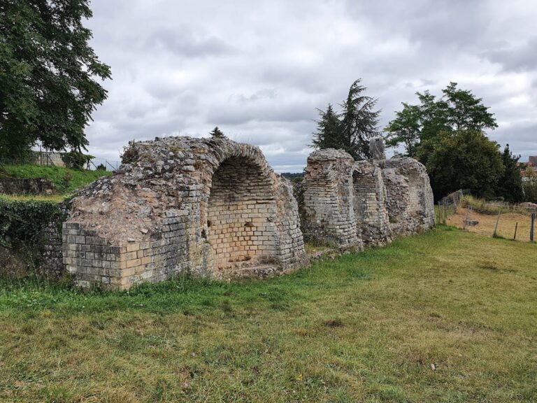
The canal bridge at the Vallon des Arcs extended for 160 metres and stood approximately 20 metres high. Two arched piers remain visible southwest of Fontcouverte village in the Saintes golf-course area, and bases belonging to other piers also survive.
Les Arcs and La Grille
Another bridge extended for about 400 metres between Les Arcs and La Grille. At Hautmont it crossed a stream and its valley, forming part of the long sequence of elevated works that carried the water channel across the terrain.
Later remains and archaeological evidence
Surviving evidence includes the bridge masonry, underground sections of the channels, the springs with their later washhouses, and a section of channel displayed in the Saintes Archaeological Museum. The Font Morillon spring installation preserves the relationship between the natural source, its retaining structure, and the Roman channel. At Font Morillon, the uncovered collapsed domed room provides further evidence for the construction surrounding the spring.
Channels from the left bank extend toward the Butte de l’Hôpital, reflecting the wider distribution of water infrastructure around Saintes. The aqueduct’s physical remains also include the landscape of tunnels, open channels, and bridges through which the water travelled from Fontcouverte and Le Douhet toward the Roman city.