Crickhowell Castle: A Medieval Norman Fortress in Wales


Site at a Glance
- Rating
- 4.2
- Popularity
- Low
- Country
- United Kingdom
- Primary era
- Medieval
- External website
- Open
- Eras represented
- Medieval
- Civilizations
- Norman
- Site type
- Military
- Remains
- Castle
On this page10 sections
History
Crickhowell Castle is a medieval Norman fortress in the United Kingdom, positioned above the town of Crickhowell. It was established around 1121 as a motte-and-bailey castle, a fortified mound beside an enclosed courtyard, probably by Robert Turberville, a member of a prominent Norman family. The castle formed part of the lands held by Bernard de Neufmarché, the Norman lord involved in the conquest and organization of the medieval lordship of Brycheiniog in south Wales.
The Turberville Castle
Welsh rebels led by Seisyllt ap Rhirid attacked the castle in 1172. Despite this assault, the Turberville family retained the lordship for more than 150 years. Richard Turberville held Crickhowell during the early thirteenth century, while Edmund de Turberville was later recorded as its lord.
During the thirteenth century, the earth-and-timber stronghold was refortified in stone. Around 1242, the marriage of Sybil Turberville to Sir Grimbold Pauncefote brought the castle into Pauncefote possession. The stone shell keep, a substantial enclosure built on a motte, and the surrounding ring wall are associated with Hugh de Turberville around 1272.
Hugh held the castle from 1273 as a mesne lord, meaning that he held land or rights through a superior lord rather than directly from the Crown. He was also Seneschal of Gascony, a senior official responsible for territorial administration, and was commissioned by Edward I to train Welsh men-at-arms and help turn a royal levy into a disciplined army. Hugh led cavalry and 6,000 infantry recruited in the Welsh Marches, served later as constable of Castell y Bere, and fought the rising of Rhys ap Maredudd from 1287 to 1291. He died in 1293 as the last member of the direct Turberville line.
Mortimer and Pauncefote Lordship
In the fourteenth century, Crickhowell Castle passed to the Mortimers, a powerful aristocratic family whose lands and titles included extensive territories in the Welsh Marches. A Marcher Lord governed and defended this border territory, where castles had military and administrative functions. Within the Mortimers’ much larger group of lands, titles, and castles, Crickhowell became a relatively small holding and declined in importance. Its alternative name, Alisby’s Castle, is associated with Gerald Alisby, a former governor of the castle.
Destruction and Later Decline
In 1400, the newly installed King Henry IV ordered the castle to be refortified in preparation for the uprising led by Owain Glyndŵr, the Welsh prince who directed a major rebellion against English rule. Sir John Pauncefote carried out the work, but Glyndŵr’s forces captured and largely destroyed Crickhowell Castle around 1403. They also attacked and burned Abergavenny and other settlements in the region.
The castle is thought to have been abandoned after its destruction. In the fifteenth century it passed to Sir William Herbert, 1st Earl of Pembroke, a Welsh Marcher nobleman who became an important regional lord under Edward IV. In 1463, Edward granted Crickhowell to Herbert as an independent lordship, making him a Marcher Lord. The fortifications were probably never restored. By the sixteenth century, the castle was regarded as entirely ruinous and supplied stone for the surrounding borough. Later stone-robbing further reduced the remains.
The surviving remains received statutory protection in 1963 as a Grade I listed building and a Scheduled Monument. Grade I is the highest category of protection for historic buildings in England and Wales, while a Scheduled Monument is a nationally protected archaeological or historic site. An archaeological survey also established that the so-called Ivy Tower, once thought to belong to the fourteenth-century castle, was substantially later and unrelated to Crickhowell Castle.
Remains
Crickhowell Castle occupies a spur above Crickhowell, where a tributary stream meets the River Usk. The town was planned around this elevated position. The surviving layout preserves the relationship between the oval motte, the stone stronghold on its summit, and the large bailey, or enclosed courtyard, that extended beside it.
Earthworks and Bailey
The oval motte remains clearly visible as the principal earthwork. Most of the shell keep’s foundations are buried, with slight remains surviving at the summit. The stone castle also included substantial walls, several towers, and a large bailey enclosed by a stone ring wall. Traces of this bailey have been identified in the nearby playing field, helping define the extent of the medieval fortified enclosure.
Stone Fortifications
South-Eastern Tower
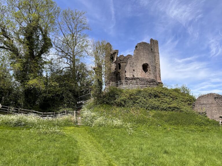
A substantial surviving section belongs to a large tower at the south-eastern corner of the castle, where the bailey met the motte. Together with the visible earthwork and the remains on the summit, it illustrates the castle’s combination of an earlier raised defensive position with later stone construction.
South-Western Gateway
Another surviving section forms part of the gate at the south-western corner of the bailey. The gateway was formerly flanked by two round towers, and considerable masonry remains from one of them. The ruined stone double tower on Castle Green forms part of the broader surviving group of castle walls and motte. Nineteenth-century illustrations indicate that the condition of these ruins deteriorated noticeably during the following century.
Associated Features
Some historians have proposed that Crickhowell Castle replaced an earlier motte-and-bailey structure at nearby Maescelyn. St Mary’s Chapel, which has existed since around 1300, has also been linked with the castle, although the nature of that relationship remains uncertain.
Nearby sites