Sassai Castle: A Twelfth-Century Frontier Fortress in Sardinia


Site at a Glance
- Rating
- 4.2
- Popularity
- Low
- Country
- Italy
- Primary era
- Medieval
- Eras represented
- Medieval
- Civilizations
- Unclassified
- Site type
- Military
- Remains
- Castle
On this page18 sections
History
Sassai Castle, also known as Castello Orguglioso or Orgoglioso, is a twelfth-century fortified building in Silius, Italy. Built by order of the Judges of Cagliari, one of the rulers of Sardinia’s independent medieval kingdoms, it formed part of a frontier defense system facing the Judicate of Arborea, another Sardinian kingdom. Together with Quirra Castle, it watched the surrounding countryside and the routes along the Flumendosa.
A frontier fortress of Cagliari
The castle occupies a position about 430 metres above sea level. From this elevated site, it could oversee the territories of Silius, San Nicolo Gerrei, Goni, and Ballao, as well as a substantial stretch of the Flumendosa. It also controlled routes along the river’s right bank toward Pauli Gerrei, Silius, the Campidano of Cagliari, and Trexenta. The name Orguglioso, meaning “proud” or “valiant,” may belong to a medieval group of warrior epithets associated with chivalric legends and strategically placed strongholds.
The castle’s military role became especially clear under Pisan control. After Santa Igia, the medieval capital of the Judicate of Cagliari, was conquered and destroyed in 1258, the former judicate territory was divided among Giovanni Visconti of Gallura, Guglielmo of Capraia of Arborea, and the Pisans Ugolino and Gherardo della Gherardesca of Donoratico. Cagliari itself, known in Latin as Castrum Calari, remained directly dependent on Pisa. Sassai Castle was already Pisan property by 1265.
Pisan administration and military use
The earliest surviving documentary mention of Orguglioso dates to 1286. In that year, Mariano II of Arborea granted the castles of Baratuli, Montenuovo, and Orguglioso to the Commune of Pisa. On 31 August 1314, a document issued at Pisa appointed Pietro di Buccio of Cortona to inspect the provisioning of Orguglioso, Acquafredda, and Quirra. Under Pisan control, the castle probably also helped supervise nearby mines producing fluorite, barite, and silver-bearing galena.
The provisioning records portray a strongly military installation. They refer to a garrison of 700 cavalrymen and numerous infantrymen, although the difficult terrain meant that mounted troops were otherwise kept to a minimum. The surrounding landscape was rocky, austere, and densely wooded, making the castle more suitable for military control than for a large mounted force. The settlement of Sassai lay beneath the fortress, with its parish church dedicated to Saint Mary and the Presentation of the Blessed Virgin Mary about 400 metres to the south, at the present-day Intra Idda estate.
Aragonese conquest and destruction
At the beginning of the Aragonese conquest of Sardinia in 1323, Orguglioso remained in Pisan hands. The Crown of Aragon was the composite monarchy that expanded into Sardinia during this conquest. By 1345, the castle was listed among the strongholds held by the Crown. On 18 August 1350, King Peter of Aragon granted the fief of Orguglioso to Nicolò Carroz through an investiture diploma. The same document called the nearby settlement the Villa of Sassai, a name repeated in another diploma dated 23 October 1356.
During the Sardinian-Catalan War, the major conflict between Aragonese forces and the Judicate of Arborea that began with Mariano IV of Arborea’s rebellion in 1353, Orguglioso was besieged and captured by Arborean supporters from the Cagliari area. Giovanni Francesco Fara later attributed the operation to partisans led by Pietro da Sena, an Arborean commander who was active in the region with 800 cavalrymen and 7,000 infantrymen. The possibility that the garrison surrendered without central support to protect the nearby village of Sassai remains uncertain.
The peace concluded on 11 July 1355 did not return Orguglioso to the castles newly garrisoned by the Aragonese. The fortress was abandoned and destroyed, and it was never rebuilt. An Aragonese inventory from 1358 described it as partly ruined, although its accompanying sketch probably did not accurately represent the structure. The castle had remained active for about a century, with its final thirty years under Spanish control.
The decline of Sassai
The settlement below the castle also lost importance after the garrison was withdrawn. Giovanni Francesco Fara later placed Sassai among the inhabited places of the Curatoria of Siurgus, a medieval administrative district, and the Diocese of Dolia, an ecclesiastical district governed by a bishop. In 1421, Lodovico De Ponzonibus sold its territory to Nicolò Bottaro together with twenty-five other villages, including Mandas.
By 1570, Sassai had no parish priest of its own and was attached to the parish of Pauli Gerrei. Its priest used the title “Rector of Gerrei and Sassai.” The last rector was appointed on 22 February 1691. Seven years later, Sassai no longer existed as a settlement.
Excavation and interpretation
The castle was investigated and restored through four interventions by the Municipality of Silius and the Cagliari and Oristano Superintendency for Architectural, Landscape, Historical, Artistic, and Ethno-Anthropological Heritage. Work began in 1995, when thick vegetation and collapsed stone covered most of the site, leaving only a short section of the keep visible. Campaigns in 1998, 2000, and 2007 removed extensive collapse deposits and revealed the perimeter walls and internal rooms.
Archaeological and architectural analysis identified two main phases of use. The first was residential, while the second converted and reduced the spaces for fortified use. Excavation and restoration brought the structure back into view and supported the sequence of abandonment and destruction. Sassai Castle is recognized as Italian national heritage.
A local legend tells of a castellan who owned a precious golden loom. In one version, Arborean partisans caused the vault above the room containing it to collapse, killing the castellan and burying the loom. In another, the soldiers hid the loom near the site’s only fig tree before the occupation. Excavation found no loom. Pastoral tradition also connected the ruins with the castellan’s nightly lamentations and ghost.
Remains
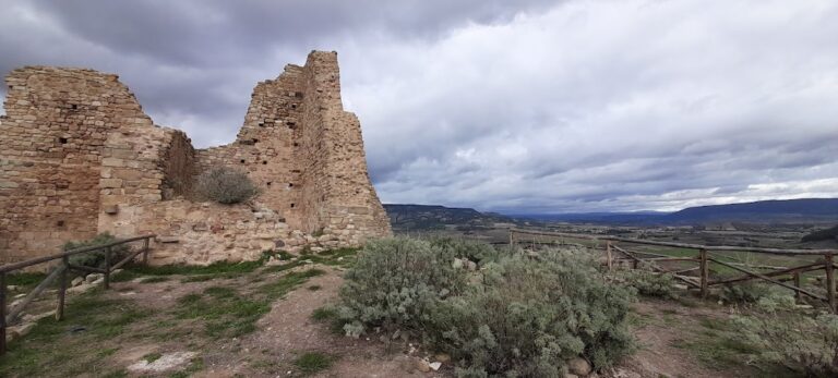
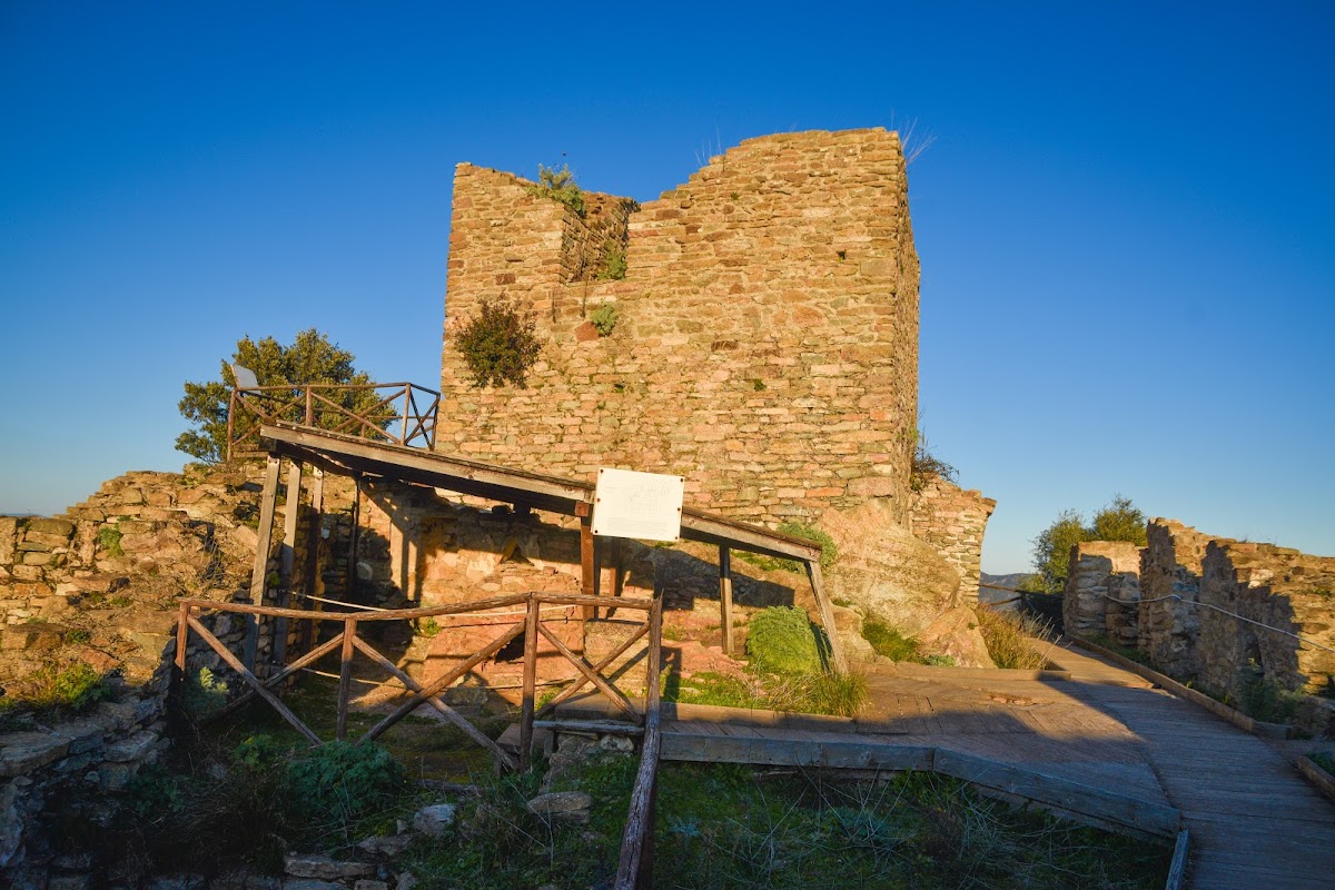
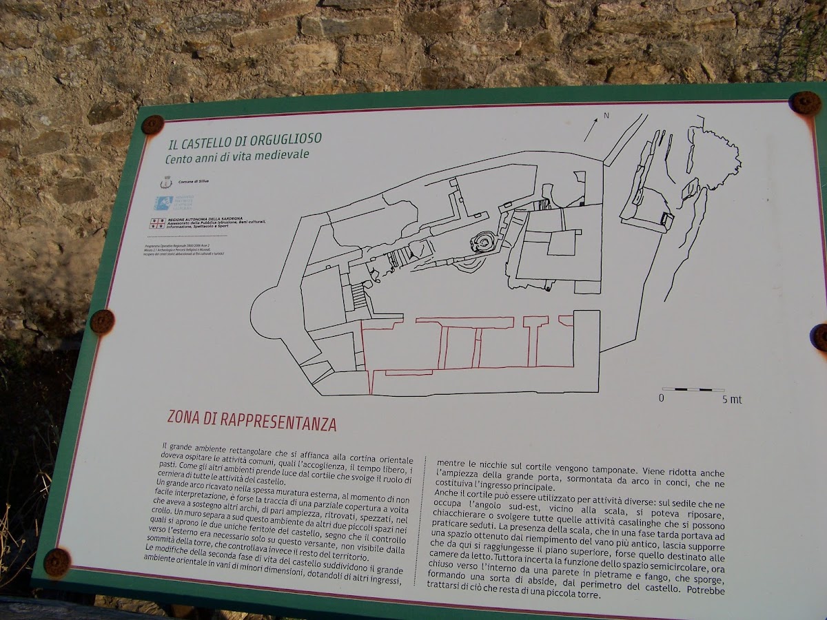
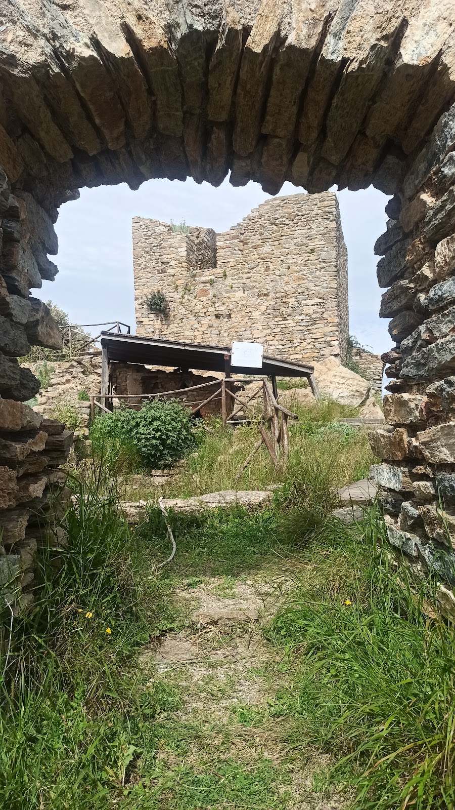
The surviving castle occupies a natural saddle and follows the exposed bedrock. Its walls rest directly on the rock, which was cut into working surfaces and cisterns. The remains form an irregular trapezoid. A northern entrance, a principal tower, projecting towers, internal rooms, and a large central courtyard define the surviving layout.
Walls, entrance, and defensive structures
Keep and outer walls
A quadrangular keep stood at the northern end of the castle and incorporated the entrance. A semicircular tower joined the walls on the southwest, while a second circular tower formed part of the southwestern outer defensive wall. Two outward-opening arrow slits remain visible in the southeast walls. The first construction phase used small, roughly dressed stones set in lime mortar, with regular masonry and carefully finished surfaces. Door arches, courtyard niches, and some service rooms had frames made from precisely shaped stone blocks.
Access ramp and entrance passage
A northern path connected the castle with the main road. Near the entrance, both the access ramp and a narrow passage beside the wall were cut into the exposed rock. A small terrace immediately below the ramp served as a stable and rubbish dump. The sole entrance was a broad doorway with an arch made from carefully shaped wedge-shaped stones, known as voussoirs. It opened into a paved corridor.
A large built-in storage jar stood on the right side of the corridor against the tower and held water. Burnt remains and cooking vessels nearby suggest that people entering the castle may have been offered water or a hot drink. The corridor led into the large rectangular courtyard, which served as the operational center and provided access to the other rooms.
Courtyard and service rooms
Central courtyard and raised area
The courtyard was used for communal activities, reception, leisure, and meals. A raised area beside the tower could be reached by a stair ramp from the courtyard. Further steps lay on the southern side of the castle, while the tower was probably reached by a fixed or movable wooden ladder. The raised area may have connected with a first floor above the service rooms.
Kitchens and ovens
The kitchens opened onto the courtyard. They contain a hemispherical-domed oven described as the only known medieval Sardinian example of this type to have remained unmodified. A cooking hearth and a sunken storeroom stood nearby. A second, larger oven occupied the courtyard. Its mouth was built into the partition wall between the kitchen and courtyard, although only the opening survives.
The kitchen walls contain niches and red-painted drawings on the plaster. These paintings are among the oldest known medieval pictorial testimonies in Sardinia, and the castle is described as the only known civil context on the island with such representations. The most prominent figures are two people shown in profile, wearing trapezoidal garments and drawn with small hands and legs. One appears to hold a bow. A rougher central image may depict a building beside a heraldic shield, while the letters L, M, and A were scratched below in carefully formed writing.
Upper room and storage chambers
A small opening led to a room above the cisterns that has since disappeared. Three niches opened in its walls, each framed by arches made from shaped stone blocks. Traces of lamp smoke remain around the niches. Excavation in the oven area uncovered substantial quantities of material and broad remains of lime flooring that may have been laid above wooden floors, supporting the likelihood that the castle had at least one upper storey.
An irregular chamber along the western curtain wall was cut against the bare rock. Its non-waterproof plaster lining and the lack of water-conveyance systems indicate that it was not a rainwater cistern. Its position beside the kitchens suggests that it may instead have stored provisions, especially grain. The room had a vaulted covering and a trapdoor along its southern edge for access or removal of its contents.
A second chamber beside it also had a barrel-vaulted roof, parts of which survive. It opened onto the courtyard and may have stored materials and tools or served as a prison. Iron rings found inside support the possibility of imprisonment.
Construction changes and excavated objects
Later fortified phase
The later fortified phase was less elaborate than the first. Large rooms were divided into smaller spaces by partitions built against the earlier walls. These partitions used irregular rubble bonded with mud, contrasting with the carefully finished masonry and shaped stone frames of the earlier construction.
Domestic equipment and food remains
Excavation recovered tableware and kitchen equipment, including plates, cups, glazed bowls, archaic Pisan maiolica jugs, a large Iberian dish decorated with a six-pointed star, several glass cups, and a flask. Other containers included amphorae for water, jars for oil or water, and vessels for fruit and legumes. Work equipment included numerous nails and a basalt grain mill with its pestle and shovel.
Clothing accessories included metal buttons, four bronze and iron belt buckles, and a bronze ring. Objects connected with leisure included a gaming die, a bone flute, and a rattle. A shell valve still carried traces of red lead pigment, which was used for lip and cheek makeup. Byzantine and medieval coins were also recovered. Animal remains consisted mainly of cattle and goats, along with approximately twenty birds and one fish.
Human remains on the entrance terrace
The entrance terrace contained most of the pottery fragments and also a human skeleton. The body lay on its right side, with the head turned right, the chin resting on the shoulder, the left arm bent above the head, and the right arm across the pelvis. Its position followed the slope of the ground and showed no clear evidence of a formal burial.
The skeleton belonged to a man approximately 30 to 40 years old and about 1.70 metres tall. Numerous wounds and fractures suggest that he may have been a soldier injured and killed during a military conflict.