Castle of Alcantarilha: A Fortified Algarve Complex in Portugal



Site at a Glance
- Rating
- 3.8
- Popularity
- Low
- Country
- Portugal
- Primary era
- Early Modern
- Eras represented
- Medieval, Early Modern
- Civilizations
- Portuguese
- Site type
- Military
- Remains
- Castle
On this page9 sections
History
The Castle of Alcantarilha, also known as the Walls of Alcantarilha, is a fortified complex in Alcantarilha, Portugal, whose origins are traditionally placed in the Islamic period and generally dated to the twelfth century. It occupied a strategic position in the Algarve, helping defend the interior while guarding against attacks by forces landing on the coast.
Early settlement and Islamic rule
Alcantarilha was inhabited from antiquity. The earliest settlement may have been a Lusitanian hillfort occupied during the transition from the Neolithic to the Chalcolithic. Roman forces may have conquered it around 198 BC, after which it was used as a military base connected with the port of Armação de Pêra.
During the Islamic period, the settlement stood beside a bridge on the road between Faro and Silves, the region’s principal cities. Its name is believed to derive from the Arabic term al-qantarâ, referring to the bridge. The castle is generally regarded as an Islamic-period foundation, although some interpretations place its construction after the Christian conquest or attribute substantial building and repair to the sixteenth century.
Christian conquest and later fortification
Christian forces led by Paio Peres Correia, a military leader of the Christian conquest of the Algarve, conquered Alcantarilha during the thirteenth-century reign of Alfonso III. The castle continued to hold strategic value, and Alfonso III is said to have ordered major works at the fortress. The relatively oval form of Alcantarilha’s upper streets may preserve evidence of this intervention.
Major wall construction probably began in the sixteenth century, possibly during the reign of John III. The settlement was sacked by Moorish pirates in 1550 and attacked again in 1559. During the latter attack, women and children took refuge in Silves because Alcantarilha lacked adequate defenses. These events may have encouraged the construction or repair of the walls, although the chronology of the work remains debated.
In 1571, Sebastian I ordered the completion of the walls. He visited Alcantarilha on 28 January 1573 to inspect the works, which still had a military purpose in protecting the Algarve’s interior and guarding against coastal landings. A description from 1577 continued to identify the enclosure as unfinished. The sixteenth-century building campaign profoundly changed the castle and almost completely removed its original Islamic architectural character.
Seventeenth-century plans and decline
In 1621, Alexandre Massai, an Italian military engineer working on Algarve fortifications, reported that only one bastion and parts of the walls were complete. The seaward sections had been built, but work had stopped because of a lack of funds. Massai recommended completing the walls to the height of the existing bastion, using stone and lime, strengthening the landward side, digging a surrounding ditch, and drawing on local assistance. He considered the project important for protecting nearby Pera and Pedra da Galé and their coastal fishing installations.
Alcantarilha’s militia in the early seventeenth century consisted of 27 mounted men and 221 infantrymen. Massai’s proposed plan envisaged a hexagonal fortification along the crest of the elevation, with part of the enclosure facing south and the remainder protected by a ditch. The castle underwent further restoration in 1640 during the Portuguese Restoration War, the conflict through which Portugal regained independence from the Spanish Habsburg monarchy.
From the eighteenth century, the castle entered a prolonged decline, possibly after the earthquake of 1755. In 1758, the parish priest reported only slight damage to Alcantarilha’s church and did not refer to the walls. The arch of the Village Gate was probably demolished during the eighteenth century, and its materials were reused in a bridge over the Ribeira de Alcantarilha.
Modern alteration and protection
The Municipal Market of Alcantarilha, inaugurated on 2 July 1934, was built partly against the castle wall. Although the castle was still considered to be in good condition during the 1940s, later urban expansion destroyed much of the complex, substantially changed the area inside the walls, and led to the demolition of large sections of the enclosure.
In 1973, Portuguese cultural authorities informed the municipality of Silves that the castle was to be classified as a Property of Public Interest, a Portuguese heritage designation that provides statutory protection to places considered to possess cultural value. The protection process began in 1974 and proposed a general zone extending 50 metres from the site. Objections from property owners and the castle’s owner did not prevent classification, which was completed on 29 September 1977 under Decree 129/77.
The surviving remains have held this designation since 1977. The protected area covers the largest surviving wall section but not another identified section near Rua do Lagar. Archaeological prospecting took place in 2000 during a land-consolidation project in the Vale da Vila and Alcantarilha areas of Silves. Archaeological monitoring on Rua das Palmeiras in 2011 sought ancient remains and investigated the possibility of another surviving wall section.
Remains
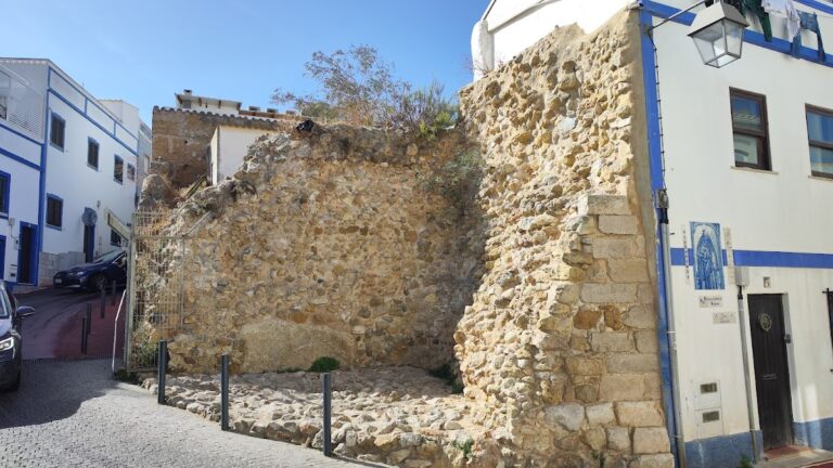
The surviving remains lie in Alcantarilha’s historic centre beside Rua da Misericórdia, Travessa do Castelo, and Largo General Humberto Delgado. At its greatest extent, the castle formed a fortified enclosure with six bastions, one at each corner, and a principal arched gate. The remaining walls are heavily degraded and are partly concealed by, or incorporated into, modern buildings. Evidence found beneath modern Rua das Palmeiras indicates that an older road, probably used from the sixteenth or seventeenth century, ran beside the castle.
Travessa do Castelo wall
The largest exposed wall section stands beside Travessa do Castelo. It measures approximately 12 metres in length and 4.5 metres in height, adjoins buildings to the northwest and southeast, and is built from small stones arranged irregularly. Its masonry differs markedly from that identified in Islamic castles elsewhere in the Algarve and is considered by several authors to be medieval.
Bastion and defensive openings
At the southeast side of the enclosure, beside Rua de Nossa Senhora do Carmo, a corner of a bastion remains visible. One face of its limestone corner masonry narrows from the base toward the top. A curved opening of dressed stone beside Travessa do Castelo contains a door on its southwest side and a window approximately four metres above ground level on its northwest side.
Other surviving wall sections retain loopholes, narrow openings used by defenders for observation or weapons, together with crenellations, the raised and notched elements of a defensive parapet. These features show that the castle once possessed a wall-walk, although the wall-walk itself has disappeared.
Rua do Lagar tower and wall
Along the east side of Rua do Lagar, another section of wall and part of a tower survive. A private residence was built into the tower, which retains a projecting orelhão, an ear-like feature incorporated into a fortification to help protect an adjoining wall or flank. The tower’s structure is comparable to towers in the Walls of Lagos known as Santo António, Gafaria, Quartos, and Paiol. The wall beside Rua do Lagar continues north beyond the junction with Rua das Escadinhas do Lagar.