Burg Groitzsch: A Medieval Castle and Archaeological Earthwork in Germany


Site at a Glance
- Rating
- 4.4
- Popularity
- Low
- Country
- Germany
- Primary era
- Medieval
- Eras represented
- Medieval
- Civilizations
- Holy Roman Empire
- Site type
- Military
- Remains
- Castle
On this page16 sections
History
Burg Groitzsch is a medieval archaeological hilltop fortification in Germany, associated with Count Wiprecht of Groitzsch in the late eleventh and early twelfth centuries. Developed through five successive castle periods from the tenth century to about 1300, it became one of the largest fortifications in the region. Its round chapel and round tower, built during the Romanesque period, are regarded as the oldest known stone buildings in Saxony.
The name and earliest fortifications
The name Groitzsch derives from the Slavic term grodisce, meaning a fortified place or castle rampart. The first secure documentary reference dates from about 1073 or 1074, when Wiprecht acquired the castle through an exchange involving territory near Stendal and Tangermunde.
The earliest fortification was probably founded in the first half of the tenth century and destroyed by fire during the second half of that century. Its creation is commonly connected with the conquests of King Henry I in 928, an expansion of royal power associated with the establishment of frontier fortifications in eastern Saxony. Burg Groitzsch may also have replaced an earlier rampart at Altengroitzsch, about 2 kilometres to the south.
A second fortification was built from the late tenth century and may have continued until about 1080. Extensive burnt layers show that it ended in destruction, although the precise cause remains uncertain. The damage may have resulted from conflicts between Wiprecht and neighbouring nobles during the 1070s, or from the Investiture Controversy, the medieval struggle between the papacy and secular rulers over ecclesiastical appointments. The Battle of Hohenmolsen in 1080 formed part of that wider conflict.
Wiprecht’s castle
Castle III existed approximately from 1080 to 1120 and is securely identified with Wiprecht of Groitzsch, a powerful count in central Germany. The Pegau Annals, medieval records from the nearby monastery of Pegau, describe a complete redesign and the construction of two towers in 1080.
This rebuilding marked the transition from timber-and-earth defenses to masonry bonded with mortar. Wiprecht’s political connections with Bohemia and Moravia are reflected in the form of the round chapel. His marriage to Judith of Bohemia, a daughter of a king from the Přemyslid ruling dynasty, further illustrates the international connections of his household.
The end of Castle III is marked by a destruction layer dating to the first decades of the twelfth century. It may have been connected with the conflicts between Wiprecht and Emperor Henry V around 1115, when the castle was captured and recaptured several times. A radiocarbon result gives a date of 1120 plus or minus 40 years, while pottery and other finds also place the destruction in the early twelfth century.
Wettin control and the end of the medieval castle
Castle IV lasted approximately from 1120 to 1224. After the Groitzsch family died out in 1144, the castle passed to Dedo V of the Wettin dynasty through his marriage to Bertha, Wiprecht’s daughter. Dedo, known as “the Fat,” probably lived at his castle in Rochlitz rather than at Groitzsch.
In 1224, Landgrave Louis IV of Thuringia, known as “the Saint,” besieged the fortification and burned its outer bailey. These actions very probably brought Castle IV to an end. Castle V began around 1224 and continued until about 1300, although its role appears to have changed substantially from that of the earlier castles.
Castle V was probably destroyed during the wars of succession in 1294 or 1296 by troops of Adolf of Nassau. Its final destruction may instead have occurred, at the latest, when the forces of Adolf’s successor, King Albert I, passed through the area in 1306 or 1307. A small motte, a fortified earthen mound, continued on the western edge of the castle hill. The rights and duties connected with the burgrave’s office passed to this smaller fortification, although the office of Groitzsch had largely lost its importance.
Excavation and preservation
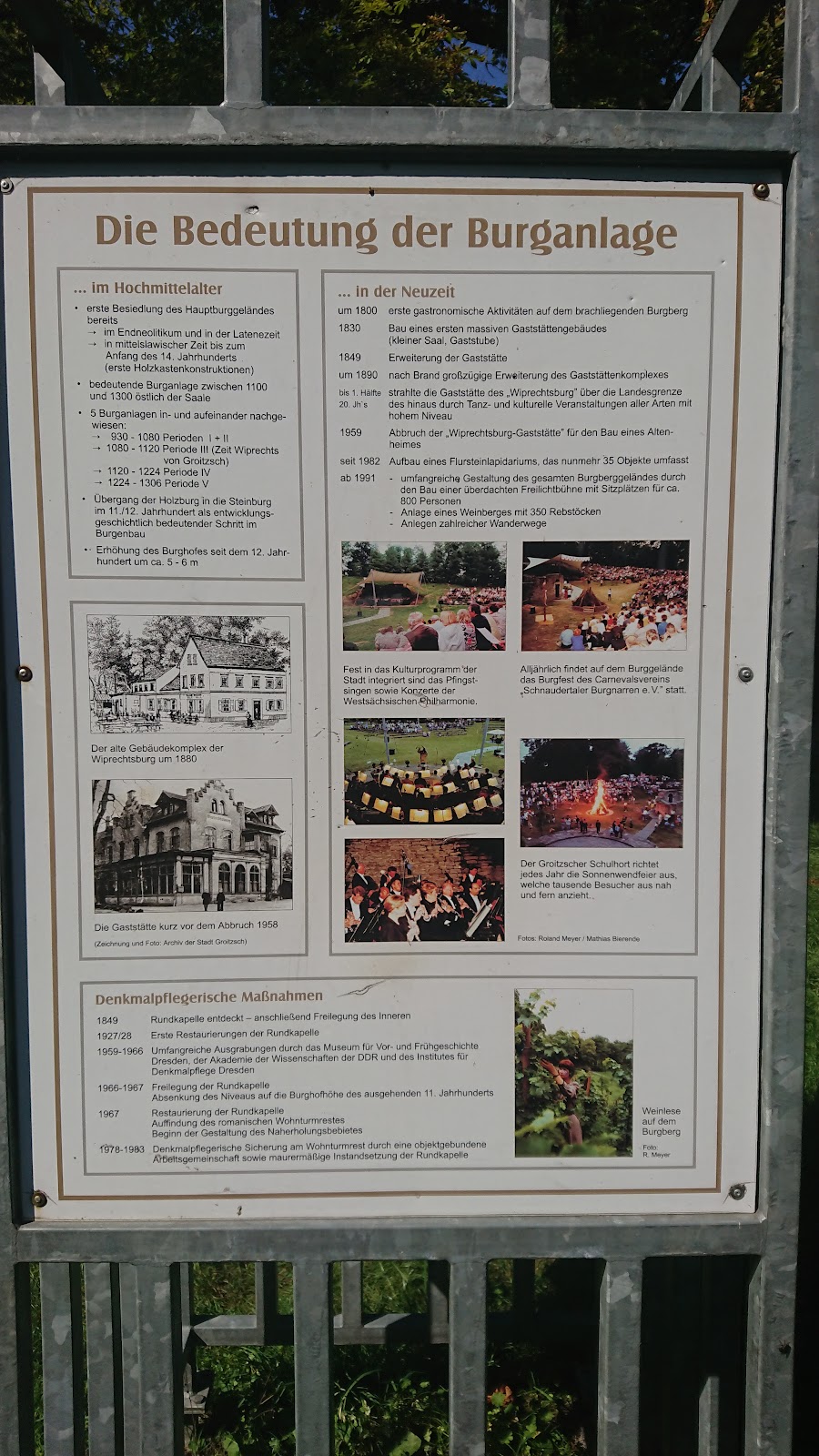
The castle area was investigated as early as 1743, when Baron von Schwedendorf, lord of the Groitzsch court, ordered excavations. Construction work for an inn exposed the walls and interior of the Romanesque rotunda in 1849. Erosion and rubbish soon filled the excavated interior, leading to another excavation about seventy-five years later. An 1863 attempt to drain the Schwennigke in search of Wiprecht’s treasure recovered fish, a modern horseshoe, a sword blade, and a sword basket.
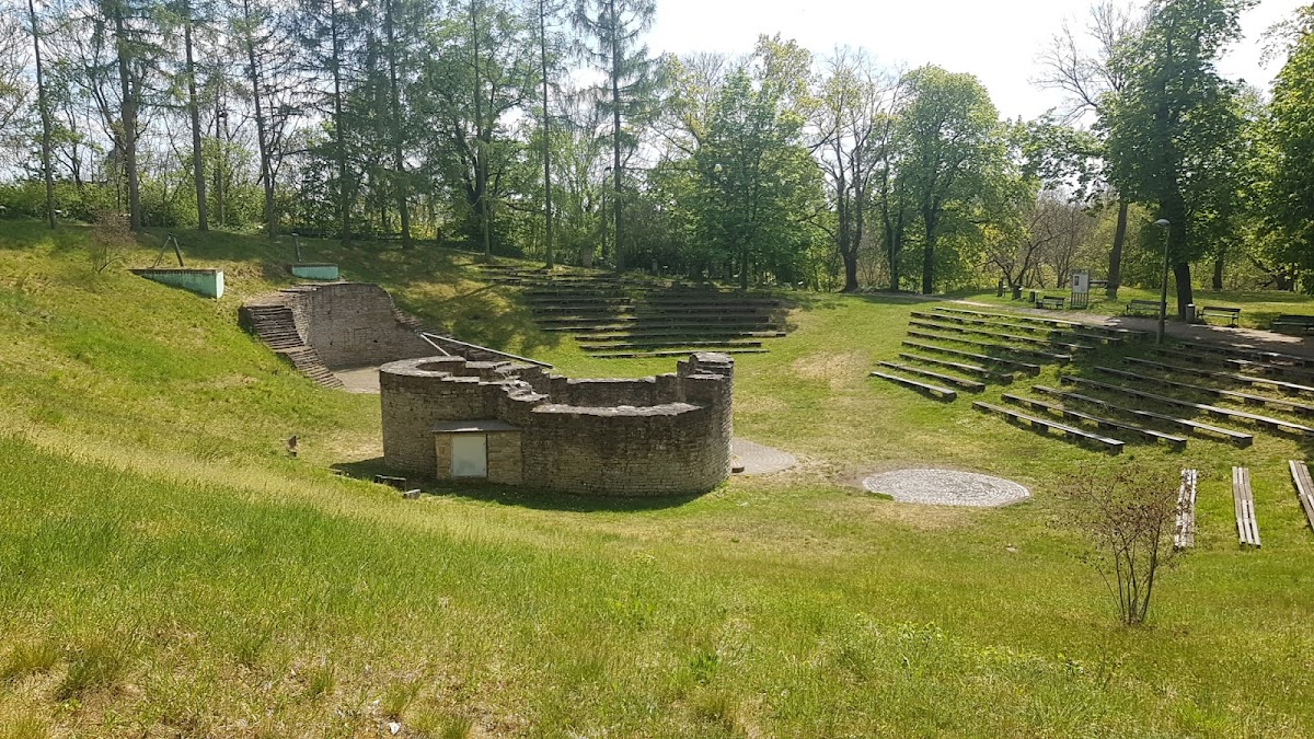
Groitzsch was placed under monument protection in 1936. Investigations connected with a planned old people’s home began in 1959 and developed into long-term excavations that continued until 1967 or 1968 under Heinz-Joachim Vogt. The round chapel and the remains of the Romanesque round tower were later restored, while the surrounding area was reshaped as an amphitheater-like recreational landscape. The castle is represented in a permanent archaeological exhibition at the State Museum of Archaeology in Chemnitz.
Remains
Burg Groitzsch occupies a promontory of Pleistocene gravel projecting into the broad valley of the White Elster. The Schwennigke surrounds the site to the southwest, west, and north, while the Schnauder flows farther east. This position created a naturally defended spur for the castle. The main castle measures about 150 by 100 metres. A surviving eastern rampart is approximately 4 metres high, while the other sides descend steeply toward the Schwennigke. The main castle lies west of the modern road and stands about 10 to 12 metres above it.
Castle layout and outer defenses
The modern road from Pegau to Groitzsch follows much of the medieval castle ditch, formerly a broad dry ditch. East of the road, the outer bailey covered roughly three times the area of the main castle. It was originally fortified, but its eastern side preserves the principal surviving traces, and a further outer ditch can be followed only in part.
The former outer-bailey area contains a nursery, a cemetery, and a church precinct with remains of the Romanesque Church of St. Mary. The medieval old town of Groitzsch adjoins the bailey to the south. Excavations produced deposits more than 6 metres thick, preserving changes in construction, settlement, and material culture across five castle periods. These finds also gave their name to the Middle and Late Slavic “Groitzsch Group” of ceramics.
Early timber-and-earth defenses
Castle I
In Period I, probably founded in the first half of the tenth century, the lowest part of the rampart consisted of a timber grid at least 8 metres wide and 2.8 metres high. It was made from halved oak trunks and small round timbers. A timber-and-earth wall 2.9 metres wide stood on its inner face, backed by an outer packing of humus-rich clay about 5 metres wide.
A probable timber building stood immediately behind the wall, with a hearth about 4 metres behind its rear face, probably belonging to a sunken-floor house. Another such house was destroyed in the fire that affected the fortification. The interior was then leveled, and settlement debris was tipped down the slope, extending the northern side by nearly 20 metres. Finds included Neolithic pottery and stone tools, especially material associated with the Funnel Beaker culture, as well as smaller quantities of Bronze Age and Iron Age objects. A fragment of a rowel spur probably dates to the first half of the tenth century.
Castle II
Period II was built on the leveled remains of Castle I. Its builders constructed a similar timber grid and piled rubble against the slope to support the wall. A large timber structure in the eastern part of the excavated area may have been a tower or a gate. Settlement was denser than in Period I and extended across the interior, with several hearths and parts of sunken-floor houses.
Animal bones show that domestic animals supplied 98.6 percent of the identified remains, with pigs predominating. Hunting played a secondary role, although wild boar was the most frequent game animal. Bone awls, needles, and sliding bones were found, the latter probably serving as runners for moving heavy loads. Iron objects included spurs, tang knives, and fire steels, while other finds included a possible wooden bucket-handle fragment, kettle hooks, fittings, and belt components. Iron slag indicates that one or more smiths worked at the castle.
Castle III and the first stone buildings
Massive rampart
Period III, dating approximately from 1080 to 1120, introduced entirely new defensive principles. Earlier rubble formed the foundation of a massive sand-and-gravel rampart with a base 27 to 30 metres wide. It rose 8 to 10 metres above the contemporary courtyard, and its outer slope was shifted outward by an average of 10 metres.
The inner face consisted of a timber box construction 2.8 metres thick. Horizontally laid, upright, and interlocked planks formed boxes about 3.8 metres long and 0.8 to 3.5 metres wide. These were filled with sand, coarse gravel, and locally clay. Some sections survived to a height of 3.2 metres, and the timber-and-earth wall could be traced for more than 25 metres along the northern, eastern, and southern sides. The rampart crown was 15 to 18 metres wide and may have supported additional defensive buildings. An earthen embankment apparently divided the interior into eastern and western areas, although the larger western section was not excavated.
Round tower
The round tower had an internal diameter of 9.3 metres and walls 2 metres thick. It probably combined residential and defensive functions and may have been one of the two towers mentioned in the Pegau Annals. Early Period III settlement included timber houses behind the rampart boxes and a sunken-floor house with an entrance ramp. A layer of stone chips above the Period II deposits suggests that this building may have been a stoneworkers’ workshop connected with construction of the tower.
Round chapel
A round chapel was built about 10 metres from the tower soon afterward. Its interior measured 6.4 metres across and ended in a horseshoe-shaped apse, a curved sanctuary space. The chapel is associated with the Romanesque architectural development that introduced masonry buildings at Groitzsch and influenced further sacred and secular stone construction in Upper Saxony during the twelfth century.
Four successive courtyard surfaces followed the chapel’s construction, some using plank paving. Thick clay layers over the planks required repeated renewal. During the second courtyard phase, a timber house stood in the north only 50 centimetres behind the rampart boxes. It used the same construction technique, and a collapsed domed oven occupied one corner.
After the fifth courtyard was completed, part of the castle was destroyed and rubble covered the surface. At the same time, the outer bailey expanded with a probably palisaded fortification and more intensive settlement. A predecessor of the Romanesque Church of St. Mary may also have been built during this phase.
Period III remains reflect an aristocratic household. The castle received selected, meat-rich portions of cattle rather than whole animals. Wild species made up only 1.2 percent of the animal remains but included red deer, wild boar, elk, bison, and brown bear. Birds of prey probably relate to falconry, while peacock and dachshund-like dog remains point to courtly culture. Other finds included decorated bone objects, glass finger rings, bronze fittings, a lead steelyard and probable weight, a gold bridle bit with checkerboard decoration, horseshoes, and weapons-related material. Pottery included late Slavic wares and a new thin-walled, wheel-thrown, harder-fired earthenware.
Castle IV and the raised courtyard
Castle IV no longer survives as a distinct fortification because later leveling removed it. Evidence on the outer slope led Heinz-Joachim Vogt to infer that it was enclosed by a brick wall. During this period, the courtyard was raised by at least 3 to 4 metres, bringing it closer to the level of the rampart crown and helping counter persistent dampness.
Large box-like structures filled with rubble were built across the castle. The area between the round chapel and tower was initially left open, and the chapel remained in use with access only from the northwest at its former level. During further leveling in the first third of the thirteenth century, the remaining rubble-filled boxes were completed and the courtyard was brought to a uniform height. The chapel was then abandoned, while the round tower continued in use, increasingly embedded in the raised ground.
A timber-framed building in the southeastern corner contained the oldest pot-tile stove known east of the Saale before it was removed. Both timber-framed and brick buildings stood within the castle. Finds included sliding bones, knife blades, scabbard fittings, sharpening stones, grinding stones, nails, a bronze bell, and a bronze object with a spike of uncertain function. Unevenly fired earthenware continued to dominate the pottery.
Castle V and the final destruction
Period V retained roughly the dimensions of the preceding castle but used two parallel brick walls, one along the slope and another around the outer edge of the castle area. Two vaulted rectangular brick towers with central supports were excavated in the northeast. Each measured about 10 metres along its internal sides and probably formed part of the defenses.
The interior was raised with rubble from the destruction of Castle IV. Accessible parts of the round tower were gradually dismantled for stone, while several brick buildings occupied the castle. Their surviving walls and probable foundation bases indicate different functions, although later building activity disturbed the shallow remains. Probable horse stables stood on the southern side. Glazed roof tiles and gable finials gave the complex a representative character.
Castle V ended in violent destruction, represented by rubble and ash layers containing human remains. It produced the richest assemblage from the five fortifications. Gray and blue-gray earthenware became dominant, and glazed pottery increased. Finds included a glazed toy horse and rider, fragments of two aquamanilia, tools such as drills, chisels, and axes, bone handles, knives, keys, currycombs, bridle pieces, horseshoes, spurs, stirrups, a sword crossguard, and arrow and crossbow heads. A bracteate box made between 1280 and 1288, together with the pottery sequence, places the end of occupation around 1300.
The round chapel is partially reconstructed, and the stump of the round tower remains visible. Both originated during the rebuilding of Castle III around 1080. The modern grounds also include an amphitheater-shaped area, a vineyard with more than 5,000 vines, flower beds, walking paths, and a lapidarium displaying about forty regional field and boundary stones.