Peyrepertuse: A Medieval Royal Frontier Fortress in France
Site at a Glance
- Rating
- 4.7
- Popularity
- Medium
- Country
- France
- Primary era
- Medieval
- External website
- Open
- Eras represented
- Medieval
- Civilizations
- French
- Site type
- Military
- Remains
- Castle
On this page18 sections
History
Peyrepertuse is a medieval fortified castle in France, built and strengthened during the medieval period on a limestone ridge above Duilhac-sous-Peyrepertuse. Its name comes from the Occitan Pèirapertusa, meaning “pierced stone.” The site became a major royal frontier fortress after the French conquest of the thirteenth century and is traditionally counted among the “Five Sons of Carcassonne.”
Early occupation and changing lordships
Archaeological excavations have revealed occupation or remains dating from the beginning of the first century BC. The surrounding territory belonged to the County of Razès until 874, before passing during the tenth century to the counts of Cerdanya and Besalú. A castle was established on the ridge by the early eleventh century.
Before 1010, Peyrepertuse came under Bernard Taillefer, count of Besalú. In 1111 it was incorporated into the County of Barcelona and later came under the Viscounty of Narbonne. From about 1180, the region became a de facto frontier after Alphonse II, count of Barcelona and later king of Aragon, freed himself from French suzerainty. The castle therefore occupied a politically contested position before it became a formal royal stronghold.
The Albigensian Crusade and French conquest
During the Albigensian Crusade, the thirteenth-century campaign against the Cathars and political powers associated with them in Languedoc, Peyrepertuse was the fief of Guillaume de Peyrepertuse. Cathars were members of a Christian movement that the medieval Catholic Church regarded as heretical. Guillaume was excommunicated for heresy in 1224, submitted after the fall of Carcassonne, and surrendered the castle to French authority in 1240.
Before and during this conflict, the fortress served as a refuge for persecuted knights and Cathars. It consequently became one of the principal places associated with Cathar resistance. The French takeover transformed Peyrepertuse from a lordly stronghold on a disputed frontier into a possession of the crown.
Royal strengthening and the Aragonese frontier
From 1242, Louis IX ordered a major programme of strengthening. The upper Sant Jòrdi complex was constructed higher on the ridge, while the Old Keep and the existing Sainte-Marie church were repaired or remodelled. The main building phase of the Sant Jòrdi Keep took place in 1250 and 1251.
A royal account preserved in the archives of the Carcassonne seneschalship, a medieval administrative district governed by a royal official, records the work between June 1250 and June 1251. Carpenters, masons, stonecutters, and a blacksmith worked alongside lower-paid labourers. Local peasants from Rouffiac, Soulatgé, and Duilhac supplied labour, while animals hauled materials and timber was brought from nearby forests. The account also mentions cisterns, the removal of rock before the church and keep, seven entrance steps, and an ingenium, probably a treadwheel crane used to lift building materials.
The Treaty of Corbeil in 1258 fixed the frontier between France and Aragon immediately south of Peyrepertuse. The castle then became a major French royal frontier fortress within the defensive system commanded from Carcassonne. It formed part of the group traditionally known as the “Five Sons of Carcassonne,” alongside Aguilar, Puilaurens, Quéribus, and Termes, and was also associated with the wider royal network that included Montségur and Lastours.
Royal preparations continued after the main construction phase. In 1321, Carcassonne was ordered to send Peyrepertuse twenty broad-brimmed helmets, seventeen crossbows of two types, and nine iron hooks. The fortress regained a defensive role in the fourteenth century. After Henry of Trastámara, claimant to the Castilian throne, was defeated at the Battle of Nájera, Charles V of France authorized him to take refuge at Peyrepertuse in 1355.
Later military use and preservation
In 1542, Jean de Graves, lord of Sérignan, briefly seized the castle in the name of the Protestant Reformation. He was later captured and executed with four accomplices. The Treaty of the Pyrenees in 1659 moved the Franco-Spanish frontier south of the Pyrenees and ended Peyrepertuse’s strategic frontier role.
A small garrison commanded by a subordinate officer remained until the French Revolution, when the fortress was abandoned. Its guards included local villagers who were exempted from taxation in return for military duty. Peyrepertuse was sold as national property in 1820 and gradually fell into ruin. A first consolidation and restoration campaign began in 1950.
The ruins were classified as a French historic monument by decree on 19 March 1908. In 2017, the natural-site registration of the castle and its surroundings was repealed when the area was incorporated into the classified natural site of the Puech de Bugarach and the northern ridge of the Fenouillèdes syncline. In 2026, Peyrepertuse was included in the UNESCO World Heritage serial property “Capetian Royal Fortresses of Languedoc.” Its exceptional extent also explains the traditional name “Heavenly Carcassonne.”
Remains
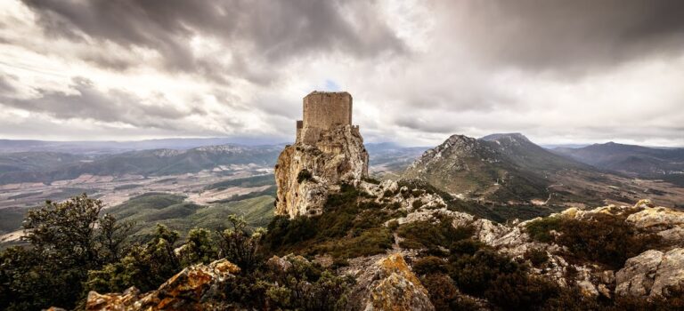
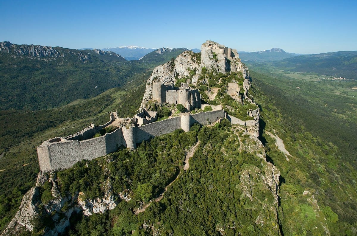
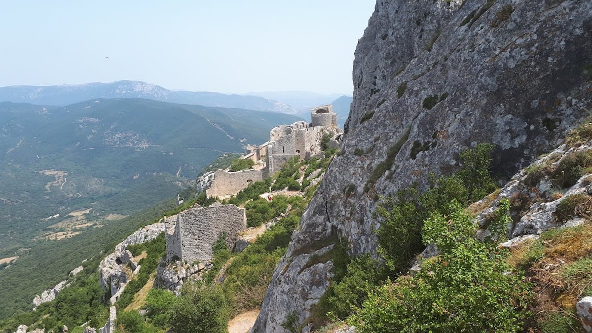
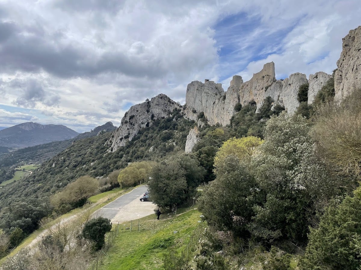
Peyrepertuse occupies a steep limestone outcrop at about 800 metres above sea level, on the ridge separating Duilhac-sous-Peyrepertuse from Rouffiac-des-Corbières. The complex extends for about 300 metres along the ridge and reaches up to 60 metres in width. Its southern side includes an abrupt drop of approximately 30 to 40 metres, while the surrounding position overlooks garrigue, vineyards, and valleys and controls mountain passes. The ridge also allowed signal communication with Quéribus to the south.
Fortifications and entrances
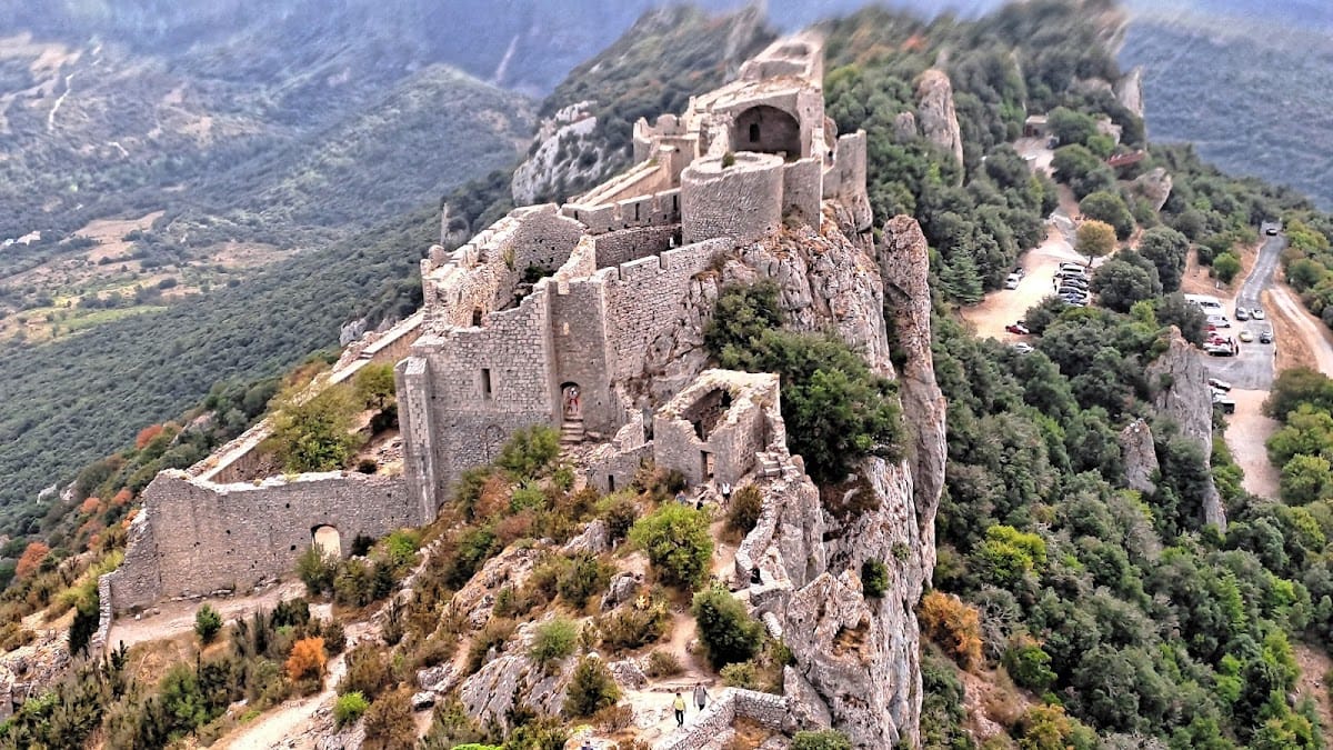
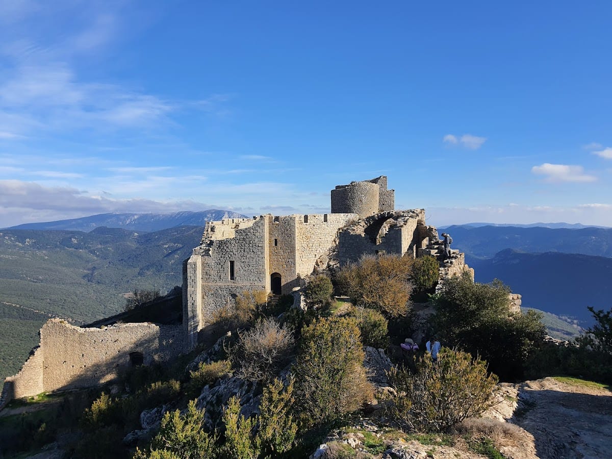
The surviving castle is arranged in three separately fortified sectors: the lower fortress with the Old Keep, a middle fortress, and the upper Sant Jòrdi Keep. Most of the visible fabric belongs to the thirteenth-century French period. Walls follow the edges of the cliffs, with the northern defenses more accessible and more substantial than those on the southern side, where steep slopes and the cliff provided much of the protection.
Entrance defenses
The principal entrance lies on the north side and was preceded by a barbican, an outer defensive structure protecting an entrance. The entrance gate occupies the northwestern angle. A concealed postern, or secondary gateway, was formerly approached by a narrow path behind a large rock spur and by a removable ladder. The postern is now closed. At the pointed end of the castle, a pierrière, a medieval stone-throwing siege engine, was positioned on the outcrop’s prow.
Lower and middle fortresses
Lower fortress
The lower fortress has a triangular plan and includes eastern and western esplanades. On the eastern esplanade, a 120-metre curtain wall, meaning a connecting defensive wall between towers or other fortified points, is flanked by two semicircular towers. Its surviving wall-walk consists of stone slabs resting on projecting corbels, which are supporting stones built out from the wall. The southern side is protected by the cliff, while a retaining wall contains channels associated with latrines.
Later residential blocks of irregular plan survive as ruins, and buildings at the northwestern side protect the main entrance. The eastern esplanade also contains the primitive castle associated with the count of Besalú, a twelfth-century chapel, and an old water cistern. The lower fortress retains many standing walls and some comparatively well-preserved rooms.
Middle fortress
The middle fortress occupies a plateau facing north. Its visible remains include a polygonal building that was formerly defended by archers. Together with the lower and upper sectors, this plateau formed part of the castle’s layered defensive arrangement along the ridge.
Old Keep
Sainte-Marie church
The Old Keep contains the Romanesque Sainte-Marie church. It had a single nave, a semicircular vaulted apse, and a roof made from split stone. A later dividing wall altered the interior. The fortified church retains its altar and part of its vault, while a cistern survives behind the church area.
Residential building
Beside the church stands a residential building with two superimposed vaulted rooms. The governor’s quarters consisted of two vaulted rooms ending in a semicircular tower. A crenellated curtain wall connects with the raised and fortified apse of Sainte-Marie, and its merlons contain arrow slits. The governor’s tower is equipped with wedge-shaped arrow slits.
Upper Sant Jòrdi complex
Sant Jòrdi Keep and stairway
The upper Sant Jòrdi castle stands on the western esplanade, built on the Sant Jòrdi rock. Its independent defenses were intended to resist attackers who had reached the main fortress. The keep is approached by the steep Saint Louis Stairway, which was cut into the rock face and constructed during the thirteenth-century strengthening works to connect the older castle with the upper stronghold.
Sant Jòrdi chapel
The Sant Jòrdi chapel had a single nave, a semicircular apse, and a flat roof. Two of the castle’s four cisterns were located in this chapel. The four reservoirs supplied the fortress with stored water and had capacities ranging from approximately 12 to 40 cubic metres. The other two were located in the church and residential areas. The royal construction account also mentions two cisterns at Popia and the repair of another.
From the upper complex, the neighboring castle of Quéribus, the Tour del Far near Tautavel, and the Força Real summit in Roussillon could be seen. Archaeologists also found ovens intended for domestic use. A vaulted passage 2.80 metres long led from the fortress to the Font de la Jaqueta spring below the castle.
Building materials and construction evidence
The fortress was built with timber, stone, metal, and rope. The royal account lists timber transport, iron, boards for doors and windows, buckets, saws or similar tools, animal harness, plaster, and tin for gutters. These materials, together with the recorded labour and lifting equipment, reflect the practical organization of the major thirteenth-century rebuilding campaign.