Golesz Castle in Krajowice: A Medieval Fortified Administrative Centre


Site at a Glance
- Rating
- 4.5
- Popularity
- Low
- Country
- Poland
- Primary era
- Medieval
- Eras represented
- Medieval, Early Modern, Modern
- Civilizations
- Kingdom of Poland
- Site type
- Military
- Remains
- Castle
On this page10 sections
History
Golesz Castle in Krajowice, Poland, is a medieval fortified site near Jasło whose history reaches back to the thirteenth and fourteenth centuries. The castle was probably built after 1420, although an earlier fortified settlement may have occupied the hill. Controlled by the Benedictine Abbey of Tyniec near Krakow, Golesz later served as an administrative centre, a court, and a defensive position on the route through the Wisłoka valley toward Hungary.
Origins and Tyniec Abbey
The earlier settlement is not listed in the 1288 register of Tyniec Abbey’s possessions, but this omission does not establish that it did not exist. In the early fourteenth century, Jakub Bogoria, the Sandomierz chamberlain, seized Golesz and other estates claimed by the abbey. On 9 February 1319, King Władysław I Łokietek awarded Golesz and the villages of Krajowice, Warzyce, Łęgorz, Cieklin, Stróże, Siepietnica, Zagórzany, and Ujazd to Michał, the abbot of Tyniec.
Bogoria seized the monastic estates again in 1320, leading to another royal judgment in the abbot’s favour. Through the mediation of Tomisław, voivode of Sandomierz, and Piotr, the Krakow standard-bearer, Bogoria agreed to return the estates. He retained Golesz, Krajowice, and Warzyce for three years against a surety of 100 grzywnas, and was required to drain Krajowice and Warzyce and to build or rebuild the fortified settlement at Golesz. Because Golesz had been mentioned in the preceding year, historian Jerzy Wyrozumski interpreted this as rebuilding. Władysław Węgrzyński instead proposed that a stone castle replaced an earlier wooden settlement at this time.
Golesz may initially have been the seat of an administrator responsible for an opole, a territorial district covering nearby Bogoria possessions. Its early development was probably linked with Jasło, although Jasło later passed to the Cistercians of Koprzywnica. After Tyniec recovered Golesz, the site became an important centre for administering the abbey’s estates in the Wisłoka basin and the Biała valley. It also protected the trade route toward Hungary and provided a gathering place for the local population during a general levy. One interpretation connects an earlier fortification, perhaps dating to the reign of Bolesław I the Brave, with the defence of a river crossing near Krajowice, but this remains uncertain.
Conflict and medieval rebuilding
During the abbacy of Jakub, from 1335 to 1338, Iwan of Klecie seized Golesz and added it to his estates. Iwan was the brother of Dymitr of Goraj and had previously opposed the abbey. The Benedictines recovered the castle after intervention by Iwan’s relatives, the Czuryłło family.
Hungarian forces commanded by Tomasz Tharczay attacked the region in 1474. Golesz was among the important sites that withstood the assault, although it suffered serious damage. Abbot Andrzej Ozga began rebuilding the castle, probably between 1477 and 1487. Archaeological evidence indicates that several surviving defensive elements, including the round tower and curtain walls, may belong to this rebuilding or to later sixteenth-century work.
Administration, law, and decline
For part of its history, Golesz was the residence of the non-castellan starosta of Jasło. A starosta was a territorial official, and at Golesz the abbot-appointed official was assisted by a burgrave and a notary. The castle also housed the highest court applying Magdeburg law to the surrounding villages. Magdeburg law regulated settlements, property, and courts in much of Central and Eastern Europe. The Golesz court also acted in practice as an appeal court for the townspeople of Brzostek.
Records name officials including Chebda in 1407, Mścisław between 1420 and 1425, Piotr Kostrzecki from 1449 to 1465, Piotr Żarnowiecki from 1473 to 1475, and Jan Strzemień in 1545. Other burgraves included Mikołaj of Sławęcin in 1407, Mikołaj Chrąst in 1418, Zygmunt in 1420, Mikołaj Chronowski in 1511, Jakub Baranowski in 1546, and Augustyn of Lincz in 1488. Municipal records identify Jan Brzechwa in 1600 and Mikołaj Gaszyński in 1614 as burgraves and starostas who lived at the castle while leasing Krajowice. In 1613, King Zygmunt III Waza granted the starosty lands to Mikołaj Struś of Komorów, starosta of Chmielnik, in recognition of military service.
The court consisted of a landvogt, or presiding municipal judge, and seven sworn lay judges appointed by the Tyniec abbot or his representative. Records from 1405 to 1546 name ten landvogts. The judges were village headmen and town officials from settlements belonging to Tyniec Abbey, with twenty-eight village headmen and two town officials rotating through the bench. Golesz continued to function into the early seventeenth century.
Transylvanian troops commanded by Prince Jerzy II Rakoczy burned the castle in 1657. This destruction is commonly associated with the end of its operation, although the evidence does not conclusively establish that it caused the final abandonment. Another interpretation connects the end of the castle with Swedish activity in the region in 1664. Golesz and Krajowice remained Tyniec Benedictine property until the Austrian partition and the dissolution of the abbey.
Ruin, memory, and archaeological research
By the first half of the nineteenth century, Golesz had become a complete ruin. Achilles Johannot, who owned nearby textile factories, transformed the former castle site into a recreational park with paths, birch handrails, bridges over ravines, and other features. The place became locally known as Żanotówka, an adaptation of Johannot’s name.
Nineteenth-century visitors and investigators, including Maciej Bogusz Stęczyński, Józef Łepkowski, Teofil Żebrawski, and Stanisław Tomkowicz, prepared descriptions, sketch plans, and an image of part of the castle. Their early plans are now regarded as unreliable. One nineteenth-century description claimed that a tower survived to about 40 feet and carried traces of glaze supposedly produced by fire.
After the Second World War, sections of the walls were dismantled for stone used in house construction. An archaeological sounding in 1957 recovered pottery dating from the thirteenth to the fifteenth centuries. In 2009, unknown individuals dug linear trenches along the walls, exposing buried sections of the ruins. The trenches were between 50 and 70 centimetres deep and extended for several dozen metres. The exposed walls were inspected, recorded, and secured, while the landowner was ordered to refill the trenches. Further digging occurred twice by August that year, but those responsible were not identified.
The disturbance led to regular archaeological research from 2010. Over three seasons, archaeologists from the Regional Museum in Rzeszów investigated 235 square metres and exposed parts of a round tower, the entrance gate, a bastion, and curtain walls. A conservation and reconstruction programme for the gate began in 2015. It filled gaps, secured the wall tops, and rebuilt the front and rear gate walls sufficiently to make the passage visible. The northern tower was later reconstructed in outline, raising its visible form more than 70 centimetres above ground level.
The ruins are entered in Poland’s register of immovable monuments under number A-156, dated 27 September 1934. They lie within the Golesz nature reserve and the Golesz Natura 2000 area, which protect exposures of Ciężkowice sandstone, subcontinental oak-hornbeam woodland, rare plants, and areas of acidic and fertile beech forest.
Remains
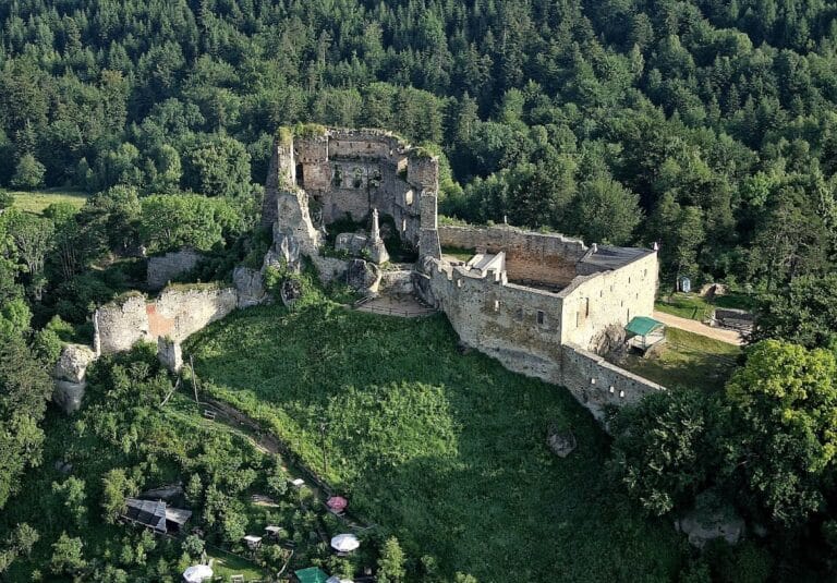
The castle occupies a distinct, domed hill on the eastern side of the Wisłoka, within the Warzycki Ridge in the southern Strzyżów Foothills. The hill rises more than 100 metres above the river valley, and the castle stands at approximately 325 metres above sea level. A probably artificial ditch at 313 to 315 metres separates the castle hill from the rest of the massif. The summit forms a pointed oval about 47 by 30 metres, while the fortification itself follows an asymmetrical polygon approaching a triangle.
Defensive layout
The round tower stood at the northern point of the enclosure, the entrance gate occupied the opposite side, and a small bastion projected from the south-western corner. Nineteenth-century descriptions mention a second round tower in the south-eastern corner, but it probably slid into the ravine. The entire complex was enclosed by an earthwork bank that still reaches about 3 metres in height. The masonry consists mainly of large sandstone blocks, with other stone used in some areas. Textures and mortars vary across the site, including clay, lime, and lime-and-sand mixtures.
Archaeological work in 2010 to 2012 exposed seven sections of curtain wall, the enclosing wall between defensive structures. They probably date no earlier than the turn of the fifteenth and sixteenth centuries and may form part of the rebuilding after the Hungarian attack. Some southern sections may be later, perhaps from around the middle of the sixteenth century. A foundation-trench tile bearing the Drzewica coat of arms, a comparable Renaissance tile from a levelling layer, and a fragment of a brown-glazed bowl support this later dating. The walls are approximately 1.5 to 2 metres thick and were built from broken sandstone and other stones set in lime-and-sand or lime mortar.
A projecting section in the south-western corner probably formed a small bastion, a projecting defensive work attached to a fortification. It is about 1.8 metres thick and consists of fairly large stones set in lime mortar.
Gate and courtyard buildings
The entrance gate was a rectangular structure approximately 12 by 10 metres, with a passage about 2.5 metres wide. Its relatively large, regular rectangular stone blocks differ from the more angular stones used in the curtain walls. Two rooms in the eastern part were intended for guards, according to archival references and a 2016 sounding. The gate probably dates from the sixteenth century, although material from its foundation trench does not allow a more precise date. Only the eastern wall is visible above ground, partly covered by earth and low vegetation, with a tree growing into the structure.
In the northern part of the courtyard, in front of the round tower, archaeologists found the remains of a burned room from the castle house. The feature measures approximately 8.5 by 4.5 metres and consists of daub and blackened burnt material. Traces along one side suggest a thin wooden wall. A corner of another poorly identified building was constructed on the room’s rubble and probably abutted the curtain wall. It was probably a late wooden house, represented by masonry 0.7 metres thick made from three layers of stones with smaller stones used as packing.
Towers and sandstone outcrop
The northern round tower has a regular circular plan, with an external diameter of 6 metres and an internal diameter of 2 metres. Its upper courses use large, regular stones set in lime-and-sand mortar. Lower courses contain large blocks of broken stone, while very small stones occur near the base. Material from the foundation trenches dates its construction probably to the turn of the fifteenth and sixteenth centuries. Its building may have formed part of the reconstruction after 1474, although it cannot be securely connected with a particular historical event.
A separate round tower stood on a small rise north of the castle. With an external diameter of 10.5 metres and walls 4 metres thick, it is probably the oldest masonry component of the complex. Its construction has been associated with the account of Jakub Bogoria’s stone castle after 1320. The tower remained in use no later than the end of the fifteenth century.
Opposite the entrance gate is a sandstone residual rock with a flat top, a hollow, and carved steps approaching from the south. The hollow is about 70 centimetres deep and usually holds water. Its original purpose is uncertain. It may have supported a defensive structure, served as a pre-Christian ritual place, or held a tall mast for signals, warnings, or torches. A local tradition associated healing powers with the water. Until the Second World War, visitors reportedly prayed there, drew water for sick people, and left coins in the hollow. In 1970, folklorist Franciszek Kotula recorded the belief that it was bottomless and reached through the hill.
Two additional rocks lower down have a regular opening between them. Local tradition interprets this as a gateway to the castle, although the feature is not regarded as an archaeological gate. Nearby remains include burial mounds associated with the Corded Ware culture, a prehistoric tradition known for cord-impressed pottery and distinctive burial customs, as well as a military cemetery from the First World War.
Archaeological finds and traditions
Excavations recovered weapon fragments and Gothic and Renaissance stove tiles. Most of the material belongs to the Late Middle Ages, with additional objects from the early modern period, the Early Middle Ages, and earlier periods. The finds complement the surviving walls and help establish the long sequence of activity on the hill.
The name Golesz probably derives from a word meaning “bare” or “bald,” perhaps referring to a formerly unforested hill whose openness aided defence. Older records spell the name as Golos or Golesch. Legends connected with the site include tales of buried treasure, the ghost of a Bogoria knight, and a tavern visited by King Jan Kazimierz Waza. Another story concerns a hermit-knight named Ścibor, who supposedly lived during the reign of Władysław Łokietek, defended the castle against Tatars by creating warriors, and was eventually carried away by a fiery spirit. The tale, titled “Zamczysko,” appeared in the periodical Lwowianin in 1841.