Mehmed Paša Sokolović Bridge: An Ottoman Crossing of the Drina
Site at a Glance
- Popularity
- Very High
- Country
- Bosnia and Herzegovina
- Primary era
- Early Modern
- Eras represented
- Early Modern, Modern
- Civilizations
- Ottoman
- Site type
- Infrastructure
- Remains
- Bridge
On this page15 sections
History
Ottoman construction and local life
The Mehmed Paša Sokolović Bridge is an Ottoman stone crossing of the Drina at Višegrad, Bosnia and Herzegovina, built from 1571 to 1577 during the Ottoman classical period. A wooden bridge had crossed the river there earlier in the sixteenth century. Grand Vizier Mehmed Paša Sokolović, the Ottoman Empire’s chief minister, commissioned the new bridge as a tribute to his native region. Mimar Sinan, a leading architect of the Ottoman court, designed it. Sokolović served under Suleiman the Magnificent, Selim II, and Murad III.
The bridge occupied a strategic route connecting Bosnia and Serbia, linking Bosnia with Constantinople by way of Sarajevo and continuing toward the Adriatic. Travelers, merchants, caravans, and military forces used the crossing. Its widened central platform, known as the kapija-sofa, became a gathering place for people from Višegrad and nearby communities. They met there, drank coffee in the open air, and heard official decisions and judgments announced. The bridge also served as a toll station. A wooden watchtower stood at its center, probably from the early nineteenth century, though its construction date is uncertain. It may have been built during the First Serbian Uprising, a revolt against Ottoman rule from 1804 to 1813. A register from 1845 lists taxes collected in Višegrad and the surrounding area. The tower was removed in 1886. The central platform’s social role diminished as motor traffic increased, and local sayings came to invoke the bridge as an image of strength and firmness of faith.
Repairs and wartime destruction
The bridge underwent repairs around 1664 and again in 1875. In 1896, a major flood raised the Drina 1.6 metres above the roadway and 15.4 metres above its normal level. The parapet was destroyed, but the bridge itself escaped major damage. In 1911, Austro-Hungarian officials found erosion in the timber foundations and repaired the foundations and piers. That year, the Austro-Hungarian army also mined the bridge.
During its retreat from Višegrad in 1914, the Austro-Hungarian army destroyed part of the bridge to slow the Serbian advance. Serbian forces demolished another section in 1915, and three arches were lost during the war. An iron temporary crossing carried traffic over the gap until repairs in 1939–1940 restored the bridge’s earlier form using stone from the original quarry.
In October 1943, German forces destroyed piers three through six during operations against Yugoslav partisans, bringing down five arches. People were also killed on the bridge and their bodies thrown into the Drina. The damaged arches were rebuilt in 1950–1952 to match the surviving ones. During the 1992 massacres in Višegrad, Bosniak residents, a South Slavic people historically and predominantly Muslim, were murdered and thrown into the river from the bridge. The Bosnian War of 1992–1995 did not significantly damage the bridge’s structure.
Traffic, conservation, and heritage
The bridge continued to carry road traffic into the twentieth century. In 1952, workers removed a curb where the approach ramp met the bridge to make the turn easier for vehicles. It was restored to its earlier position in 1986, when traffic shifted to a new vehicle bridge about 1.5 kilometres downstream. Motor traffic on the historic bridge was prohibited in 2003, leaving it mainly for pedestrians. Heavy use had already raised concerns: about 10,000 vehicles crossed daily in 1977. A 1979 repair added protection against moisture to the roadway and footway and used concrete in an effort to strengthen the structure. Planned foundation repairs to the fifth, sixth, and eighth piers remained incomplete for lack of funds, and work begun on the second pier in 1992 was also halted.
The Bajina Bašta hydroelectric plant, completed in 1966, and the Višegrad plant, completed in 1989, changed the Drina’s flow and raised its level. Altered water conditions and waves increased stress and erosion on the piers, while higher water obscured parts of the bridge. The World Monuments Fund, an international heritage-conservation organization, included it on its list of 100 most endangered sites in 2005. Restoration from 2011 to 2015 modified the piers and roadway, separated the west-bank ramp from the bridge, and placed stone around the piers. Stone blocks were also laid at points about 30 kilometres upstream and downstream to limit erosion. The quality of the work was later criticized; roadway stones were damaged within two years of its completion.
Bosnia and Herzegovina protected the bridge in 1951, and it was recognized as a cultural monument in 1962. It became a national monument in 2003 and a UNESCO World Heritage Site in 2007. The recognition under criteria II and IV reflects its place in cultural exchange among the Balkans, the Ottoman and Mediterranean worlds, and Christianity and Islam, as well as its value as an example of Ottoman classical architecture.
The bridge also became the central subject of Ivo Andrić’s novel The Bridge on the Drina, written in 1944 and published in 1945. Andrić, a Yugoslav writer, used its history to tell a story spanning roughly four centuries and ending in 1914, and to portray the wider region. He received the Nobel Prize in Literature in 1961.
Remains
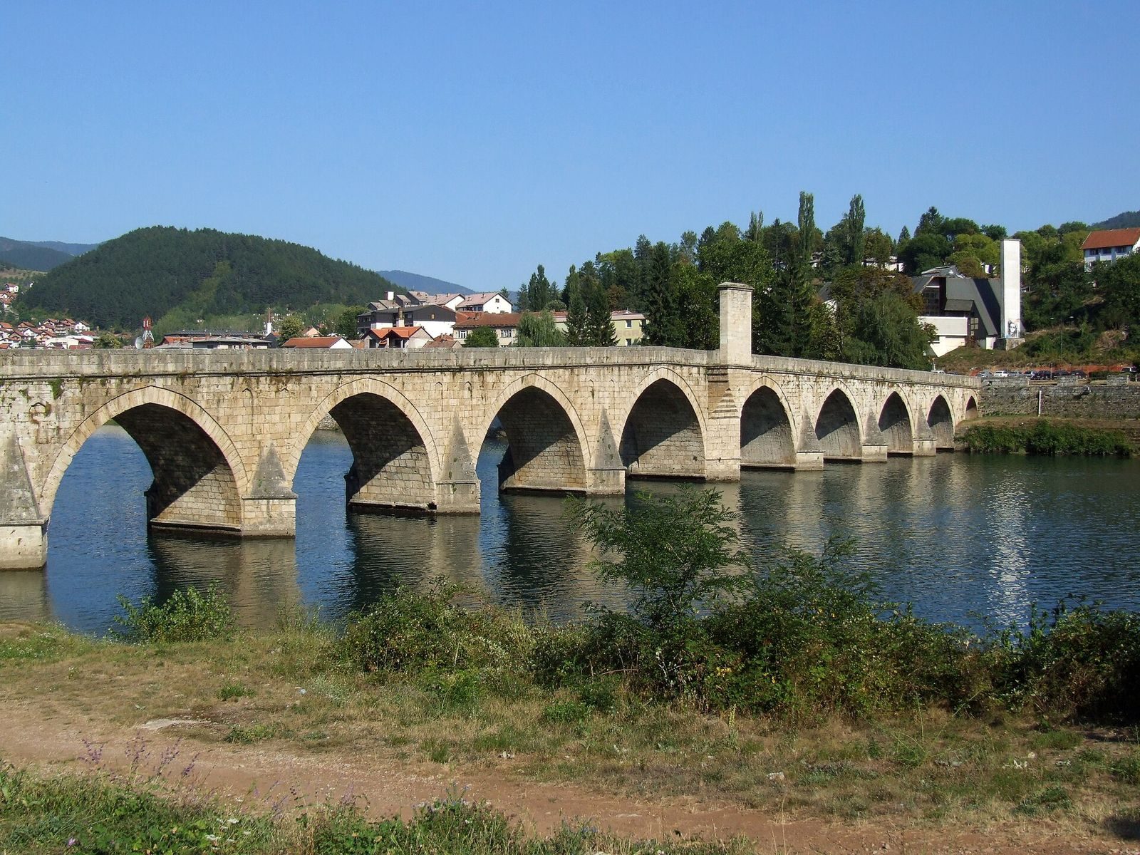
The bridge crosses the Drina on a west–east alignment, with a long approach ramp entering from the western bank at a right angle. The crossing and ramp are built of local stone quarried at Banja, about five kilometres downstream on the river’s right bank. The bridge is about 179.5 metres long and 7.2 metres wide, including parapets about 60 centimetres thick; its roadway is six metres wide.
Crossing and approach
Main river crossing
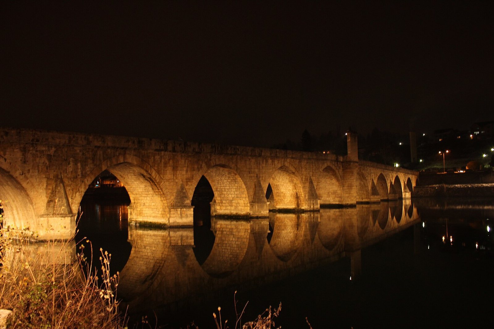
Eleven arches carry the roadway over the river. Ten openings span between 10.7 and 14.8 metres, while the shorter terminal opening at the right bank spans about 5.2 metres. Nine stone piers support the main bridge, each about 3.5 to 4 metres wide and 11.5 metres long. The terminal arch rests on two walls at different levels, with a small arch between them. The roadway rises gently toward both banks and reaches about 15.4 metres above normal water level at the sixth arch.
The arches are slightly pointed and close to semicircular, with stonework about 85 centimetres thick. They begin around the upper third of the piers and rest on projecting supports. Wall panels above the arches project only slightly beyond the arch stones and are laid in horizontal brick courses. The piers and facing walls use blocks joined with iron clamps sealed with lead, as well as lime mortar. Pointed or rounded stone projections, called cutwaters, face the current. The piers taper in steps, with pyramid-shaped upstream ends and conical downstream ends; a cornice marks the transition, and a carved stone flower tops each taper.
Western approach ramp
The approach ramp extends about 120 metres and is roughly 6.6 metres wide, including its parapets. Four arches carry it over the ground and a brook that flows into the Drina. The larger arch, at the corner where the ramp meets the bridge, spans 4.5 metres; three smaller arches complete the group. Two of the smaller arches are filled with sand.
The sixth pier and central platform
Upstream side and inscriptions
The roadway widens on both sides of the sixth pier. On its upstream side, a triangular base rises to a rectangular projection bearing a decorative blocked portal and an inscription. A high stone nearby carries a door-shaped panel with no passage and a chronogram, an inscription encoding a date. A white marble slab bears thirteen Turkish verses about the builder and the construction. Two verse inscriptions from the building period mark the work’s beginning in 1571 and completion in 1577. Their text was composed by Muhamed Karamusić Nihadi, a poet who wrote inscriptions and lived in Sarajevo.
Downstream resting place
On the downstream side, a polygonal base supports a rectangular seating platform. The widened roadway forms a resting place enclosed by stone seats, with the parapet serving as a backrest. At the base of the inscribed stone, a small fountain once sent water from the mouth of a carved stone serpent.
Other features and memorials
Former watchtower
The wooden tower that once stood at the bridge’s centre had a passage beneath it, closed by strong oak doors on both sides. Several small cannon were kept in the tower.
Legendary openings
Two openings in a pier and nearby white marks are linked to a local legend. The story says that builders, whose work was undone each night, bricked the twins Stoja and Ostoja into a pier. The legendary builder Rade Neimar supposedly left openings so their mother could nurse them. Pigeons use the openings as nesting places.
War memorial and statue
A separate marble plaque on the bridge records damage caused by German occupiers during the Second World War. A statue of Ivo Andrić stands near the bridge.