Kokino: A Bronze Age Archaeological Site and Proposed Observatory in North Macedonia
Site at a Glance
- Country
- North Macedonia
- Primary era
- Bronze Age
- Eras represented
- Bronze Age
- Civilizations
- Unclassified
- Site type
- Religious
- Remains
- Sanctuary
On this page14 sections
History
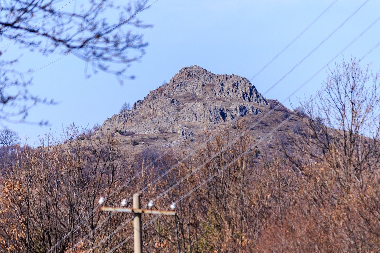
Kokino is a Bronze Age archaeological site and proposed megalithic observatory on Tatićev Kamen above the village of Kokino in North Macedonia. The Bronze Age was a prehistoric period when bronze tools and objects were widely used; megalithic describes monuments made with large stones. The proposed observatory is dated to about 1800 BC, in the Early Bronze Age, and is interpreted as a place for observing the sky and conducting rituals. Its identification as an observatory remains debated.
Bronze and Iron Age activity
The earliest archaeological finds date to about the nineteenth century BC, and evidence of activity extends from then to the seventh century BC. Finds from the Middle Bronze Age, approximately the sixteenth to fourteenth centuries BC, are the most numerous. Materials from the Late Bronze Age, approximately the fifteenth to twelfth centuries BC, are also present. These Bronze Age phase labels vary with regional chronology. An archaeological concentration from the Iron Age, when iron came into widespread use, was identified in 2009. Kokino is also classified among Paleo-Balkan cultures, a broad label for ancient cultures of the Balkans rather than a single unified culture.
Proposed observatory and ritual use
The observatory’s proposed date rests on archaeoastronomy, the study of past observations and understanding of the sky. Analysis of a marker associated with the summer solstice, when the Sun reaches its northernmost apparent position, takes precession into account. Precession is the slow change in the orientation of Earth’s axis. This analysis dates the marker, and by extension the proposed observatory, to the nineteenth century BC.
The proposed interpretation holds that people watched the Sun, Moon, stars and constellations to keep a calendar. Among the suggested targets are Aldebaran, the brightest star in Taurus, and the Pleiades, a star cluster in the same constellation, as well as the Sun at the spring and autumn equinoxes, when day and night are approximately equal in length. The arrangements may also have helped predict solar and lunar eclipses. A calendar could have guided the timing of ceremonies and seasonal work in farming and livestock keeping, although daily observation of the sky by community members remains a tentative suggestion.
Kokino is also interpreted as a sanctuary rather than a settlement with dwellings. Objects placed in rock fissures and vessels containing offerings have contributed to the interpretation of the wider site as a holy mountain. Pottery was brought in honor of the Great Mother, a title for mother-goddess figures in various ancient traditions that does not identify a particular deity here. A comparison between a rock seat at Kokino and a throne at Perperikon has not been confirmed by further scientific investigation.
Discovery and modern interpretation
Archaeologist Jovica Stankovski, director of the National Museum in Kumanovo, discovered Kokino in 2001. Museum research began late that year and continued in 2002; the first astronomical measurements were made during the summer and autumn of 2002. That year, Stankovski and astronomer Gjore Cenev presented the interpretation of Kokino as a megalithic observatory and sacred place. Archaeoastronomer Alexey Stoev investigated the proposed alignments in 2003, and Cenev continued this work afterward.
A 2005 educational poster by NASA, the United States civilian space agency, included Kokino among ancient observing locations to illustrate their geographical spread, not to rank their age or importance. The observatory interpretation remains contested because some proposed observing points and markers may reflect chance alignments. Kokino received temporary protection from the Cultural Heritage Protection Office of the Ministry of Culture on 13 November 2008. It entered UNESCO’s tentative World Heritage list in 2009 and was formally nominated in 2011. UNESCO, the United Nations Educational, Scientific and Cultural Organization, later rejected the nomination in light of the possibility that the alignments were coincidental. A tentative-list entry is a preliminary step, distinct from inscription on the World Heritage List.
Remains
The site occupies a rocky summit about 1,010 to 1,030 metres above sea level. Its volcanic hill formed from solidified lava, while weathering and erosion created fissures, some interpreted as sightlines or markers. The wider archaeological site covers about 30 hectares; the area identified as the observatory is roughly 5,000 square metres. Within it, the proposed observing area measures about 90 by 50 metres and includes two principal stepped platforms separated by an elevation difference of approximately 19 metres.
Platforms and carved features
Stepped summit
The two principal platforms form upper and lower levels. Traces of several structures and pottery fragments were found on the upper platform. The stepped rock also contains several carved seats or throne-like forms. Seats in the middle are aligned north to south, while four stone seats stand in a row on the lower platform.
Seats and passage
A rock formation resembling a throne may have served tribal elders or leaders watching the sunrise and sunset. About 20 metres southeast of the seats is a small, partly preserved observing platform, reached by a steep passage cut into the rock on that side.
Additional observing platforms
A second astronomical platform lies at the western edge of an artificially levelled terrace on the north side, where most of the archaeological artefacts were found. A third platform carries markers associated with four positions of Aldebaran between 1900 and 1500 BC.
Markers and enclosure
Solar markers
Seven stone markers are described at Kokino. Three indicate solar sunrise positions: the summer solstice, the winter solstice and the equinoxes, with one marker serving both spring and autumn. The summer-solstice marker is the best preserved. At the equinoxes, around March 21 and September 21, the Sun rises due east and sets due west. At other times of the year, its rising position shifts by as much as 45 degrees. A marked stone block on the upper platform is interpreted as indicating the summer-solstice sunrise direction when viewed from one of the seats. The proposed alignment system remains an interpretation rather than an established archaeological fact.
Lunar markers
Four markers flank the solar solstice markers. The pair beside the summer-solstice marker corresponds to winter full-Moon positions at the Moon’s greatest and least rising and setting extremes. The pair beside the winter-solstice marker relates to summer full-Moon positions at its greatest and least extremes. The Moon’s positions at these limits recur on an approximately 18.6-year cycle.
Enclosing wall
A wall about 1.20 metres wide enclosed the sacred area. It marked the boundary between this place and the surrounding area, where ritual ceremonies were not conducted.
Pottery and other finds
Excavations recovered more than 500 kilograms of Bronze Age pottery dated to about 2000–1200 BC, including both complete vessels and fragments. Finds include ceramic dishes and amphora-shaped vessels; an amphora is a two-handled container commonly used for storage. Other objects include food, weights, spindle whorls (weights used to spin fibres into thread), spearheads, moulds for buttons and spearheads, awls, arrows, knives, needles, bronze axes, pendants and ceramic figurines. Finds from the wider site, particularly from the Middle Bronze Age, also include pottery, stone mills, moulds and a pendant.