Pont Saint-Bénézet: The Medieval Rhône Bridge at Avignon
Site at a Glance
- Popularity
- Very High
- Country
- France
- Primary era
- Medieval
- Eras represented
- Medieval, Early Modern
- Civilizations
- County of Provence, French, Holy Roman Empire, Papal States
- Site type
- Military
- Remains
- Fortified Bridge
On this page16 sections
History
The Pont Saint-Bénézet is a medieval bridge over the Rhône in Avignon, France, first built between 1177 and 1185. For centuries, it provided a fixed crossing between the papally governed Comtat Venaissin and territory controlled by the French Crown. Its location also made it the only fixed Rhône crossing between Lyon and the Mediterranean.
Foundation and destruction
Tradition attributes the project to Bénézet, a shepherd from Villard in the Ardèche who was born around 1165 and died around 1184. Venerated as a Christian saint and associated with bridge builders, he was said to have heard Jesus command him to build a crossing where the Rhône’s powerful current had discouraged even Roman engineers. An initially skeptical bishop of Avignon eventually approved the undertaking, and work began in 1177.
The story relates that Bénézet demonstrated his divine mission by lifting an enormous stone and overcame other obstacles through miracles. Construction was also credited with bringing about 18 miraculous healings. Wealthy supporters organized a Bridge-Building Brotherhood to finance the work. Bénézet died before the bridge was finished and was buried in a chapel on one of its piers.
The crossing was guarded at both ends. The French Crown held the right bank, while Avignon lay on the opposite side, in the Comtat Venaissin, a territory governed by the papacy. The bridge therefore connected two areas under different political authorities as well as carrying traffic across the river.
Rebuilding and abandonment
In 1226, Louis VIII, king of France, destroyed the first bridge during his siege of Avignon. The siege took place during the Albigensian Crusade, a military campaign in southern France associated with opposition to Catharism. Work on a replacement began in 1234.
Floods repeatedly damaged the bridge, and failing arches were sometimes replaced temporarily with wooden structures before being rebuilt in stone. By the first half of the 17th century, the crossing was in poor condition. Four arches had gone by 1644, and a major flood in 1669 swept away additional sections. The cost of repairing the flood damage led to abandonment in the mid-17th century. The arches that remained later collapsed or were demolished.
Religious use and the bridge’s afterlife
Rhône boatmen regarded Saint Nicholas as their patron and initially worshipped in the chapel on the bridge. As the structure deteriorated and access became more difficult, their brotherhood built a chapel on dry ground outside Avignon’s walls in 1715, beside the gatehouse. The flood of 1856 destroyed it. During restoration work that began around 1878, a caretaker’s residence was built on the chapel’s ruins; that residence was removed during work on the bridge and gatehouse in the 1980s.
After the bridge was abandoned, Bénézet’s relics were transferred in 1670 to the Hospital of the Bridge, also called the Hospital of Saint Bénézet. The hospital stood within Avignon’s walls beside the gatehouse. The relics are now at the church of Saint-Didier in Avignon.
Later crossings
Ferries carried people across the Rhône at Avignon until the early 19th century. Between 1806 and 1818, a wooden bridge was built a few hundred metres south, at the Porte de l’Oulle, to span both branches of the river. A suspension bridge replaced its section over the Avignon branch in 1843. That bridge was demolished in 1960 when the Edouard Daladier bridge opened.
The wooden crossing over the Villeneuve branch remained until 1909, when it was replaced by a stone bridge called the Nouveau Pont. Bombing damaged the new bridge in 1944; it was repaired after the war and replaced by the Pont du Royaume in 1972.
Earlier-bridge theories and cultural memory
Whether a crossing existed at Avignon before the 12th-century bridge remains disputed. In 1882, Henri Revoil proposed a late Roman or Carolingian predecessor, a bridge associated either with the Roman-era culture of Gaul or with the Frankish dynasty that ruled much of western Europe in the 8th and 9th centuries. He based his argument on unusually large masonry blocks at the bases of surviving piers. In 1892, Louis Rochetin interpreted projecting stones near the first and second piers as possible supports for earlier Roman arches. Denis-Marcel Marié supported a Gallo-Roman bridge theory in 1953, proposing that later timber supports had linked its piers to form the 12th-century crossing.
Archaeological evidence of old timber has informed the debate, but it has not settled whether an earlier bridge existed. In 1999, archaeologist Dominique Carru judged a predecessor very unlikely. He cited the lack of mention in high-medieval chronicles, the settlement context at the proposed right-bank endpoint, and the fact that the main Roman east-west route bypassed Avignon.
The surviving arches and Saint Nicholas Chapel were listed as French historic monuments in 1840. In 1995, the arches became part of the UNESCO World Heritage property Historic Centre of Avignon: Papal Palace, Episcopal Ensemble and Avignon Bridge. The property’s recognition reflects Avignon’s leading role in the Papacy during the 14th and 15th centuries, when the institution and office of the pope shaped the city’s history.
The bridge also gave its name to the song “Sur le pont d’Avignon.” An earlier song with that title was popular in the 16th and 17th centuries. Its melody appeared in Ottaviano Petrucci’s Harmonice Musices Odhecaton of 1503–04 and was used by Pierre Certon in a mass titled “Sus le Pont d’Avignon.” The familiar later version dates to the mid-19th century. Adolphe Adam included it in the comic opera Le Sourd ou l’Auberge pleine, first performed in Paris in 1853 and adapted from a comedy by Desforges dating to 1790.
Remains
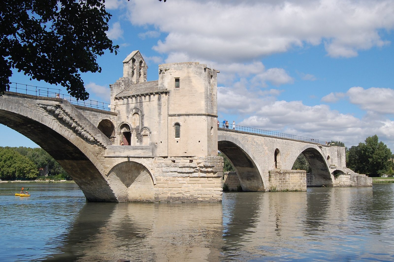
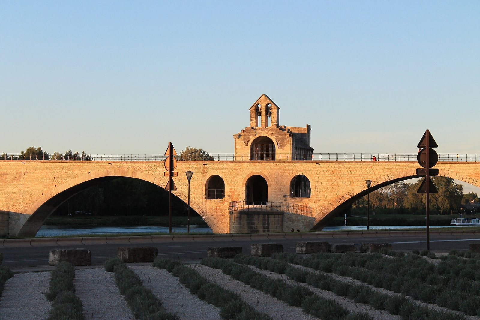
The surviving bridge follows part of a once-curving route across the Rhône floodplain. Its stone structure, former island crossings and fortified ends help explain how the crossing was arranged. Four arches remain, together with the Avignon gatehouse and the Tower of Philip the Fair at the western end.
Alignment and surviving spans
The replacement bridge had 22 arches carried on 21 piers and measured about 900 metres long and 4.9 metres wide, including its parapets. Rather than taking a direct line between the gatehouses, it curved across the river, probably responding to the positions of islands then in the channel. The Rhône has shifted across its floodplain since the bridge was built. A 17th-century map places the southern end of the Île de la Barthelasse upstream of the bridge and shows the crossing passing over smaller islands upstream of the Île de Piot. The medieval islands’ exact positions remain uncertain.
The arches are shallow, with a curve flatter than a semicircle. The widest surviving span, between the third and fourth piers, is 35.8 metres; the distances between piers ranged from 37 to 52 metres. Pointed projections, called cutwaters, extend from the piers both upstream and downstream to divide the current. Openings through the pier masonry also reduced water pressure during floods.
Some masonry from pier 11 is attached to a private building on the Île de la Barthelasse. Other pier remains lie beneath sediment on the island or in the Rhône. The arches that survive show only part of the original structure, while archaeological investigations have identified buried remains at other pier locations.
Pier foundations and timber evidence
Piers 9 and 10 now lie on the Île de la Barthelasse. Core drilling at their expected positions reached masonry about 3 metres below ground and fragments of silver fir wood, Abies alba, at about 6.7 metres. Radiocarbon ranges for the wood are AD 1238 to 1301 at pier 9 and AD 1213 to 1280 at pier 10, with both ranges calculated at two standard deviations. Beneath each of the four intact piers on the Avignon side, surveys found a wood layer at least 20 centimetres thick; one sample dates to AD 290 to 530. A 1969 survey in the Villeneuve branch found wooden beams within ruined pier 14, including a sample dated to AD 890. Dredging in that channel also recovered three large wooden piles, two still fitted with iron tips.
Chapel of Saint Nicholas
Lower chapel
The Chapel of Saint Nicholas stands on a platform on the upstream side of the second pier, between the second and third arches. Both floors contain a nave and an apse, the sanctuary end of a chapel. The lower chapel and its apse, decorated with five arches, date to the second half of the 12th century.
A later floor, supported by a ribbed vault divided into four sections, was inserted above the lower chapel, perhaps as early as the 13th century. This work may have accompanied a rise in the bridge level. The new masonry blocked the chapel’s original entrance, so a side doorway was made.
Upper chapel
The rectangular upper chapel, with a barrel-shaped vaulted roof, was consecrated in 1411. A five-sided apse with Gothic columns was added in 1513. The upper floor meets the bridge walkway, narrowing it to 1.75 metres; steps descend from the bridge to the lower floor.
Stone roof tiles over the chapel’s nave rest on corbels, projecting supports built into the wall. The polygonal apse has a flat roof above the pier’s cutwater. Blocked windows in the southeastern wall mark rebuilding work. The chapel has undergone several periods of rebuilding and restoration.
Bridge-end buildings
Avignon gatehouse
A large gatehouse at the Avignon end was built in the 14th century and substantially altered in the 15th. The bridge walkway crossed the city wall and continued down a ramp into Avignon. The ramp has since been destroyed.
Tower of Philip the Fair
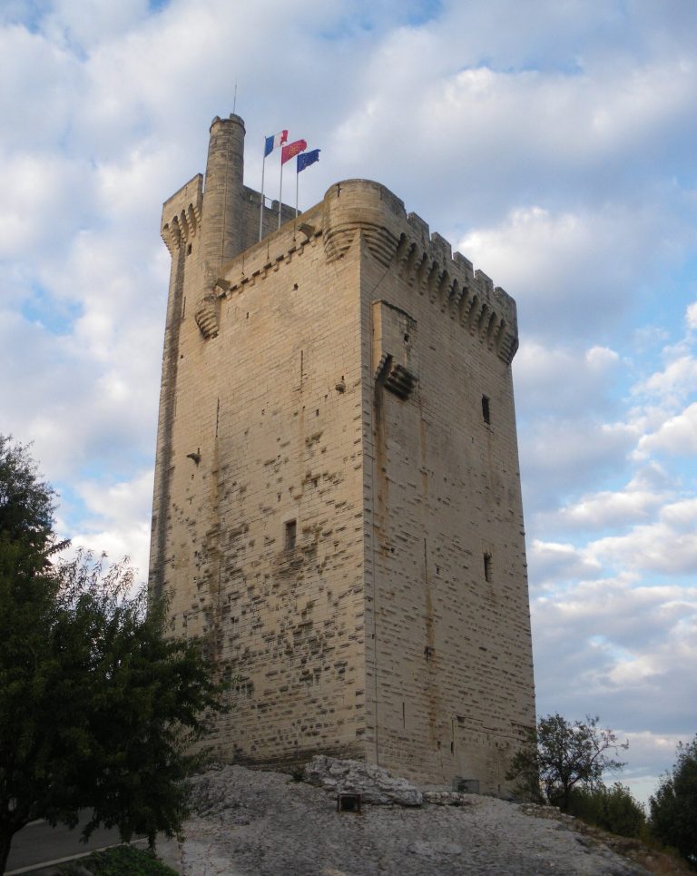
The Tower of Philip the Fair, named for Philip IV of France, was built at the beginning of the 14th century at the bridge’s right-bank end. It formed the fortified western terminus of the crossing.
Depictions of the changing bridge
The Pérussis Altarpiece, from around 1480 and the earliest known depiction of the bridge, shows a collapsed arch near the centre. Views by Étienne Martellange show arch 7 down in 1608 while arches 18 to 22 still stood near Villeneuve; in 1609, arches 7 and 14 had collapsed. Robert Bonnart’s view of 1700 shows arches 5 to 7 collapsed. Joseph Vernet’s depiction from around 1756 shows arches 9 and 11 still standing. Hubert de Saint-Didier’s view of 1824–25 records the surviving arches during restoration, while images by Isidore Dagnan in 1833 and Edward William Cooke in 1845 show the four arches that remain today.