Strageath: A Roman Fort on the Gask Ridge
Site at a Glance
- Popularity
- Low
- Country
- United Kingdom
- Primary era
- Classical
- Eras represented
- Classical
- Civilizations
- Roman
- Site type
- Military
- Remains
- Fort
On this page20 sections
History
Strageath was a Roman fort near Muthill in Scotland, United Kingdom, first occupied during the Flavian period, probably in summer AD 80. It formed part of the Gask Ridge, a chain of Roman forts and watchtowers along a military route in northern Britain. Its garrison helped protect the road toward Inchtuthil and Stracathro and may also have watched the crossing of the River Earn and the surrounding region.
Flavian fort and frontier road
The fort’s first occupation probably began during the third campaign season of Gnaeus Julius Agricola, the Roman governor who led campaigns in northern Britain. The military road and its linked forts were most likely built in AD 83 or 84. Strageath may briefly have marked the road’s northern end as Roman control advanced beyond the Earn, and troops based there may have helped build the route.
Strageath was temporarily abandoned around AD 85, when outer forts known as the Glen-blockers were established. It was later reoccupied after those outposts were given up following the departure of the Twentieth Legion from Inchtuthil. Coins from the fort indicate that it was probably abandoned again by early AD 87. This first phase was one of three separate occupations, each involving extensive rebuilding and a changed arrangement of interior buildings.
The garrison was an auxiliary cohort, a Roman army unit recruited outside the citizen legions, combining infantry and cavalry. It probably numbered about 500 soldiers. Nearby marching camps show that larger Roman forces also passed through the area temporarily. Strageath’s watch over the surrounding countryside may have extended for at least 22.8 kilometres. The fort may have helped guard territory east of the road, including Fife, from Caledonian incursions.
Antonine reoccupation
Under Emperor Antoninus Pius, Roman forces reoccupied southern Scotland in a campaign associated with the building and use of the Antonine Wall, a frontier barrier in Scotland. The reconquest, led by governor Lollius Urbicus, was probably complete around AD 142. Strageath then served as a northern outpost. Its first occupation in this period lasted until about AD 155, when an uprising among tribes in the Pennines probably prompted the withdrawal of troops from Scotland.
Roman forces returned to the Scottish Lowlands in AD 158, and Strageath was rebuilt with a larger garrison. By AD 164 at the latest, Roman troops had withdrawn to Hadrian’s Wall, the frontier barrier in northern England, probably to strengthen surveillance of the Pennines. The two Antonine occupations were distinct episodes, even if the interval between them may have been short.
During the Antonine period, the military road was resurfaced as far as Bertha. About fifty years later, the army of Emperor Septimius Severus advanced along the route and established two large marching camps near Innerpeffray Library. The camps covered 25.5 and 52.6 hectares. A further garrison at Strageath in the early third century has not been established.
Some scholars have suggested that Strageath was Victoria, a place named by the second-century geographer Ptolemy. The name may have commemorated a Roman victory over the Caledonians at Mons Graupius, but the identification is uncertain. The historian Tacitus placed that battle within a night’s march of another Roman camp, which may have been at Dornock or Dalginross; Dalginross is itself another possible location for Victoria.
Medieval church and place-name
In the Middle Ages, a parish church stood within the former Roman defences. It was founded by the Irish bishop Fergus and dedicated to St Patrick. The name Strageath comes from Gaelic and means “swamp road.” It also survives in the names of Strageath Mains, Strageath Mill, and Strageath Hall.
Records and archaeological investigation
Robert Sibbald mentioned the fort in 1695 and 1707. Alexander Gordon described and sketched it in 1726, and William Roy published a detailed plan in 1793. Aerial photography and field observations by John Kenneth Sinclair St Joseph in the 1950s and 1960s added to knowledge of the site.
The Scottish Field School of Archaeology excavated Strageath each year from 1973 to 1986, under Sheppard Frere and, from 1981, John Wilkes. The work responded in part to damage from farming and investigated the sequence of timber buildings. It disproved an earlier proposal that the first fort lay farther west than its successors. Long trenches across the interior helped reveal successive building plans, while investigation of the defences remained limited. Strageath was designated a Scheduled Monument in 1936, and the Roman Gask Project has also studied the site.
Remains
Strageath occupied about 1.82 hectares within a roughly rectangular, timber-and-earth fort measuring approximately 142.6 by 129.2 metres. Its rounded corners and defences stood on a terrace above the River Earn. Excavation revealed successive timber buildings, ramparts and ditches, as well as a stone-built bath building. Farming has heavily damaged the ancient layers; today the remains are slight ground irregularities and crop marks.
Setting and overall plan
The fort stood at the western end of the Gask Ridge line, about 5.2 kilometres southeast of Crieff and 36.6 metres above sea level. The River Earn, a tributary of the Tay, passes about 150 metres to the east. The fort occupied the eastern end of a small, level plateau of glacial sand and gravel. Steep slopes descended to the river on the north, a deeply cut stream valley protected the south, and a meander of the Earn bordered the east. Access to the plateau was possible from the west. Its relatively open ground lay amid woodland, with heavier, densely vegetated deposits around it.
The fort’s access road crossed a defended annex on the western approach. The military road bypassed the fort, running northeast down the slope toward the river. The fort stood by a ford and may have guarded an Earn crossing. A fixed wooden bridge may also have crossed the river: a steep channel about 325 metres from the fort, south of Innerpeffray Library, is a possible bridge location. A prehistoric terrace path descends toward the river in the same general area. Three Roman marching camps and traces of a road network have been identified nearby.
Western annex
A defended annex occupied the western approach, extending onto the slope north of the fort. Aerial photographs show that its size and defences changed between phases. The first annex covered about 0.58 hectares and measured roughly 100 by 57.3 metres. It lay south of the access road, with ditches protecting two sides and connecting to the fort’s outer ditch. A separate ditch may have divided it from the fort, while a rampart may have followed the access road.
In the Antonine period, the annex more than doubled in area, extending to the fort’s rampart and north to the plateau edge. Its expanded defences included two ditches set farther apart than those of the earlier enclosure, as well as an outer ditch to the west. In the final phase, the annex returned to its original area south of the access road. New ditches crossed its former northern extension and may have protected the northwestern approach or enclosed livestock.
Ramparts, gates, and ditches
Turf ramparts
Each phase had a simple rampart, a defensive bank made entirely of turf. The first was about 5.18 to 5.33 metres wide at its base and probably stood about 3.05 metres high. Small branches laid crosswise at ground level formed a timber base beneath it, with further layers set at intervals through the bank. The rampart’s broad crown could have supported a walkway. In the third phase, the bank reached about 9.68 metres in width at its base.
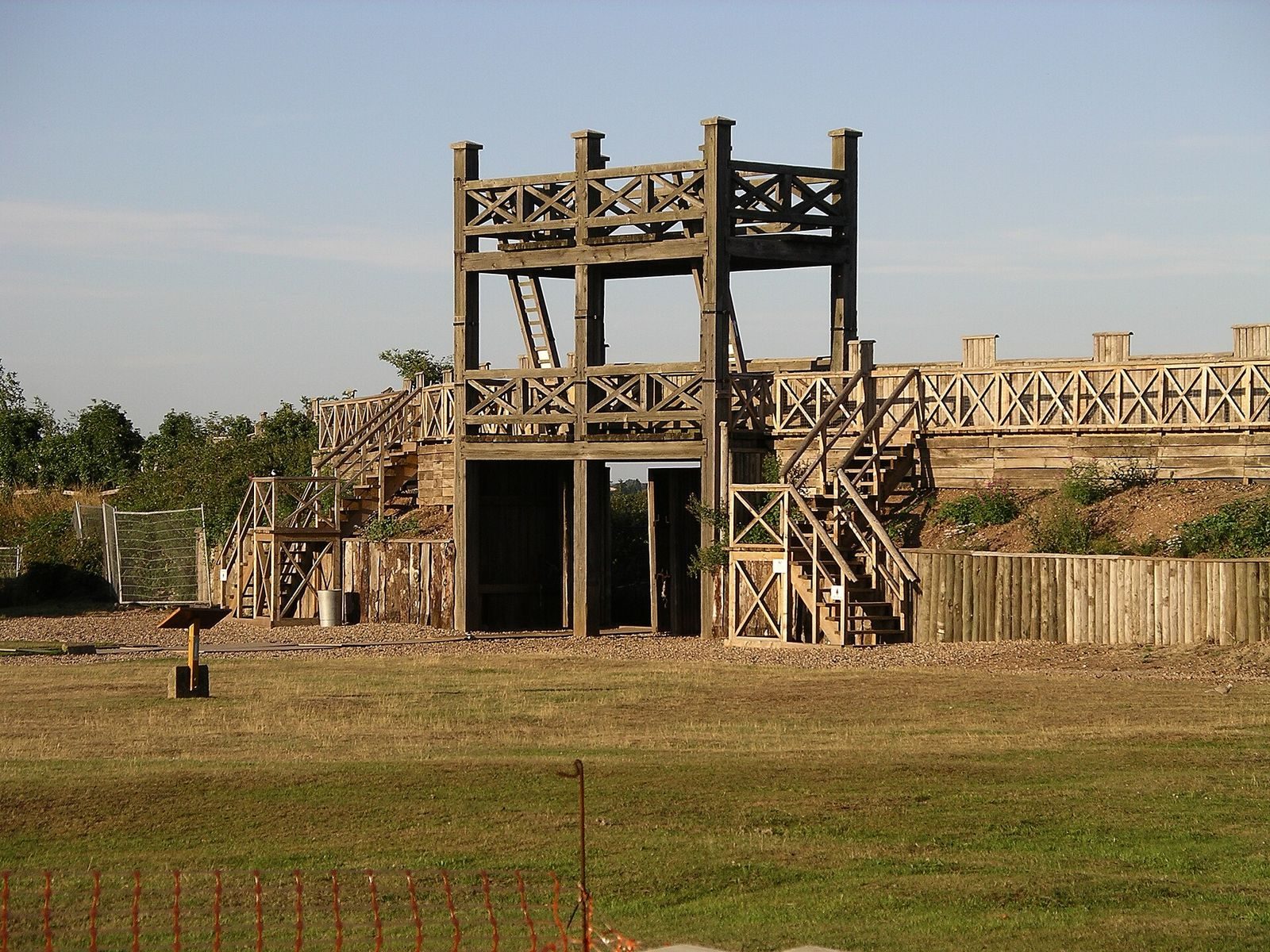
The rampart was repaired and enlarged during later occupations. The additions extended the front of the earlier bank and provided a wider walkway. Wooden strips spaced about 15 centimetres apart joined new turf layers at the front. A large posthole at the rear of the first-phase south rampart may have supported a wooden walkway about two metres wide. Stakes driven into the bank may have formed a parapet, while a turf platform may have supported steps or a ramp up to the walkway.
Gates
The three main gates of the first fort appear to have stood back from the rampart; later phases removed those structures. Excavation focused on the rear gate. It had one passage in every phase, with the first and second gates in the same position and the third moved forward as the rampart widened.
The first gate stood on gravel laid over a timber lattice, which also supported the nearby rampart. Its passage was paved with stone slabs and framed by six main posts. A wooden threshold crossed the entrance, and the substantial post foundations suggest that the gate may have carried a tower. When the fort was abandoned, the posts and plank walls were removed. Earth later covered the paving and was retained beneath the roads of subsequent phases, leaving the final passage curved.
The second gate had a passage about 4.9 metres wide and 4.88 metres long. Builders renewed the rampart front, altered the ditches, and added a new strip of turf at the rear. Large stones packed the main post foundations, and the passage was paved after its walls had been installed. Charred wood on the paving suggests that the gate burned. The third gate had a passage about 4.27 metres wide. Its shallow postholes suggest that it did not have a tower. Its road was unpaved, and an irregular line of postholes north of the gate may have supported a parapet.
Ditches
Several parallel ditches protected the fort’s south, east, and northeast sides. Their number varied, with at least three and locally as many as seven, enclosing an area about 140 metres from east to west and 130 metres from north to south. The V-shaped ditches were generally three to five metres wide and about 1.5 metres deep. A strip of ground about 2.9 metres wide separated the rampart from the innermost ditch. Some sections filled with thick deposits of burnt clay and charcoal during demolition.
Ditches IV and V may belong to the Antonine period. A bank between them, about 5.47 metres wide, contained a narrow central slot that may have held a fence or another obstacle. A nearly complete pottery bowl stamped with the potter’s name Carillus came from the innermost ditch and belongs to the second building phase. A further ditch shown in aerial photographs ran diagonally down the slope north of the fort and appears to have been linked to the second annex.
Headquarters and interior buildings
Headquarters building
The fort’s headquarters building stood at its centre, opposite the meeting point of the two principal internal roads. Known as the principia, it had three phases, and the second, Antonine building was slightly larger. The first structure measured 22.9 metres east to west by 21.3 metres north to south. Its arrangement included a courtyard, a large covered hall, and a group of administrative rooms. The central room among these was a shrine for the military standards and the emperor’s image.
The first courtyard measured 10.67 by 7.3 metres and had a pebble surface. Covered walkways, supported by closely spaced posts, bordered its north, south, and west sides. An entrance led from the courtyard to the covered hall on the east. A long room extended south of the hall; a hearth, charcoal, and iron waste near its eastern end suggest that it was used as a smithy. The other rooms served administrative or related purposes, although their individual functions are uncertain.
A water basin cut into the sand occupied the first headquarters building’s northeast corner. It measured 5.49 by 4.88 metres and was 1.52 metres deep, with an estimated capacity of about 38,200 litres. The covered hall measured 18.6 by 4.1 metres. Five rooms lay beyond it at the eastern end, including the central shrine, which measured about 5.49 metres on each side.
The second headquarters building remained in the same position and followed many of the earlier walls. It measured about 22.86 metres north to south by 23.47 metres east to west, covering 536.5 square metres, 48.7 square metres more than its predecessor. New paved roads ran along its north and south sides. A barracks building joined its rear, perhaps creating an additional room, though that space’s function is unknown.
Barracks, granaries, and bath building
Excavations identified barracks and unusually large granaries among the fort’s interior buildings. These structures were timber-framed, and their precise functions could sometimes be difficult to determine. An Antonine bath building was the notable exception to the timber construction. The buildings’ interiors were burned at the end of successive phases, while the fort’s defences remained largely intact during withdrawals.
Pits and successive rebuilding
Builders dug pits after dismantling buildings and before constructing the next phase. Later floors, roads, or walls sealed them. Some reached two to 2.2 metres deep and may have been used for waste. Other pits were deliberately filled with turf or gravel during occupation and may have held water as wells or cisterns; they were filled in when the fort was abandoned.
Roads and water supply
Roads and river crossing
The military road ran from the Innerpeffray Library area toward the fort and the watchtower chain along the Gask Ridge, while the fort’s own access road passed through the western annex. Road surfaces consisted of gravel laid over foundations of larger stones. The plateau’s deep sand made digging difficult, and the area had few substantial stone deposits. Rounded stones and much of the gravel probably came from the riverbed. A hollow in the floodplain about 240 metres north of the fort, beside the Roman road and extending below river level, may have been a gravel pit dug by the builders.
The Earn could be crossed at nearby fords when water was low, but winter conditions or heavy rain could make it difficult or impossible to cross. A fixed wooden bridge is a possibility. The steep banks restricted livestock access at the prehistoric terrace path, while horses could reach the river by a northern approach road.
Conduits and cisterns
A water conduit entered the first fort and the Antonine forts from the west. From its junction with the main road, aerial photographs trace it along the access road, though its route through the front of the fort is uncertain. A small spring about 570 metres west may have supplied it. A second spring lies 2.6 kilometres southwest of the fort, 22.8 metres higher than the plateau. Calculations for wooden or lead pipes six to seven centimetres wide suggest that the conduit could have carried 48,000 to 69,000 litres an hour before losses caused by friction.
Cisterns supplemented the conduit. In addition to the basin in the first headquarters building, a larger basin near its southern end had an estimated capacity of 48,000 litres. Other large cisterns belonged to the second fort, including one in a barracks building and another in the rear section of the fort. The method used to fill the latter is uncertain; possibilities include carrying water in barrels or collecting runoff from the rampart.
Construction and preservation
The fort’s interior buildings were timber-framed, and their roofs were probably thatched or covered with wooden shingles. Turf for much of the rampart had to be brought from elsewhere because the plateau’s grassy surface was unsuitable for cutting large blocks. Excavation identified locally cut turf in one section of the western rampart. The sand and gravel terrain shaped both the construction of the defences and the use of stone taken from the river.
Intensive farming, which increased from the eighteenth century, damaged the ancient layers. The surviving surface evidence is now faint, but excavation has revealed the fort’s changing interior plans and defensive works across its three occupations.