Castrum Celeusum: A Roman Cavalry Fort on the Danube Frontier
Site at a Glance
- Popularity
- Low
- Country
- Germany
- Primary era
- Classical
- Eras represented
- Classical, Modern
- Civilizations
- German, Roman
- Site type
- Military
- Remains
- Fort
On this page25 sections
History
Foundation and Roman service
Castrum Celeusum was a Roman cavalry fort near Pförring, Germany, about 900 metres north of the modern town. It was built to help secure a crossing of the Danube and formed part of the Raetian Limes, Rome’s frontier in the province of Raetia. The fort stood on the Danube South Road between the earlier forts of Eining and Kösching and was listed as route 15.
Pottery, including stamped fine Roman tableware called terra sigillata, points to the fort’s foundation during the reign of Trajan (AD 98–117). A timber-and-earth fort was probably constructed in the early second century. A military diploma issued at Weißenburg on 30 June AD 107, an official document recording privileges granted to auxiliary soldiers, names the Ala I Flavia singularium civium Romanorum pia fidelis. This cavalry unit of about 500 men probably garrisoned Celeusum throughout its Roman operation.
In AD 141, the unit rebuilt the fort in stone. A building inscription dedicated to Emperor Antoninus Pius records the work. The fort’s end is conventionally associated with an Alemannic attack in AD 233. The Alemanni were a confederation of Germanic peoples, and the fort may have continued in use after the attack. A coin hoard from the site ends with a coin of Severus Alexander, emperor from AD 222 to 235. Caracalla may have visited in AD 213; a fragment of a plaque with traces of gilded lettering has been interpreted as part of an honorific inscription for him.
The civilian settlement and Roman community
A civilian settlement, or vicus, grew around the fort. It included large, representative buildings and evidence of skilled crafts. The scale and number of these buildings have been interpreted as indicating that the settlement at Pförring was larger and more important than the one at Eining. A temple and a pottery workshop formed part of this community.
Roman religious practice at Celeusum included Epona, a Celtic goddess associated with horses, and the Campestres, goddesses linked with military exercise grounds. An altar connects these deities with Aelius Bassianus, commander of the cavalry unit, and a vow. Primus Saturninus, an honourably discharged officer who had served in another Roman cavalry unit, settled at Pförring in the late second century. His funerary inscription names his wife, Julia Victorina.
After Roman rule
After the Roman fort ceased operating, the area saw occasional burials during the Migration Period, an era of widespread population movements and settlement in Europe during late antiquity and the early Middle Ages. Excavations also identified an early medieval settlement and a row cemetery in the southeastern part of the former civilian settlement. A burial chamber found in 2016 near the former settlement held a wealthy young woman and is associated with Germanic newcomers who arrived after Roman forces withdrew behind the Danube.
The fort was reused as a defensive structure during the Middle Ages. Its circuit wall apparently remained in relatively good condition after Rome abandoned the frontier, helping to preserve the ancient remains. The Nibelungenlied, a medieval German epic, places a crossing near the fort at a location described as ‘at the ferrymen.’ In the poem, the Burgundian princes Giselher and Gunther travel with their sister Kriemhild toward her marriage to King Etzel, reaching the riverbank by the Roman road. The fort’s presence in the story is consistent with its continuing visibility in the medieval landscape.
Study and preservation
The site attracted scholarly attention by the sixteenth century. The Bavarian historian Johannes Aventinus knew an inscription to Epona and the Campestres and recorded other inscribed stones found in fields near Pförring. In 1838, the fort’s approaches, ramparts, and ditches remained visible, and many coins, particularly those of Hadrian, had been found. The innkeeper Ignaz Busch discovered the building inscription from the southern gate in 1843.
The Reich Limes Commission carried out the first scientific excavations, recording the fort’s layout and investigating its headquarters building. Rescue excavations followed in 1977–78 during construction of Federal Highway 299. Surveys and excavations in 2005–07 examined parts of the fort and civilian settlement. The northeast gate was investigated again in 2009–10, and a protective reconstruction was completed above its reburied remains in 2013. The building inscription dedicated to Antoninus Pius was restored in 2012. The fort and associated archaeological areas are registered archaeological monuments under Bavarian law. Intensive agriculture, erosion, and looting continue to threaten undeveloped areas; an intrusion into an excavation area in 2007 removed finds before security staff stopped it.
Remains
Setting and defences
Plateau and plan
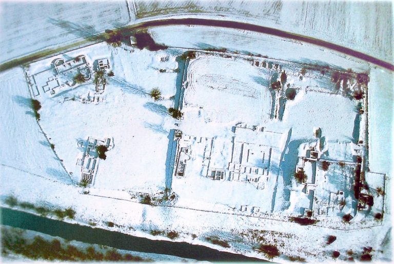
The fort occupied a small, nearly square plateau at the northeastern edge of the Kelsbach valley. Its slopes set it apart from the surrounding land, with the Danube lowland to the south and the Kelsbach stream to the west. The enclosure measured about 194 by 201 metres and covered 3.9 hectares. Its broad side faced northwest, following the line of the ancient road; the northwest gate commanded a view along the route toward Eining. A specially made outer slope survives in places to a height of five metres. Terraces on the southwest and southeast sides may have been formed while the fort platform was being prepared.
Walls, gates, and ditches
The stone perimeter had rounded corners, giving it a playing-card outline. Its limestone wall was just over a metre thick, with a timber wall-walk along the inner side and a watchtower at each corner. Each of the four gates had two passageways and a pair of flanking towers. Volcanic tuff formed the gates’ round arches, while surviving evidence indicates that the doors used thick wooden planks with iron cladding. Three V-shaped ditches ran outside the slope. At the northeast gate, the outer and inner ditches stopped before the entrance, and a wooden bridge crossed the middle ditch.
Northeast gate reconstruction
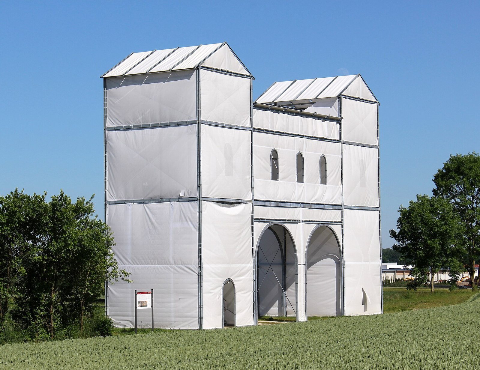
A modern steel structure marks the northeast gateway with a simplified outline of a Roman gate. The ancient remains were reburied before construction. The structure stands on piles driven five to seven metres into the ground, with a concrete slab above the ancient foundations. It rises 13 metres and is covered with textile panels. The remains of the east gate and the northern corner tower are severely deteriorated despite earlier restoration and conservation work.
Buildings inside the fort
Headquarters
The headquarters, or principia, faced northwest. A large hall for several uses stood in front of it, centred on the Via principalis, the road linking the southwest and northeast gates. Behind the hall, service and administrative rooms surrounded an open courtyard. The standard-bearing shrine and troop treasury occupied the middle of the building’s rear section. The shrine’s semicircular apse, a rounded sanctuary end, was built within the structure rather than projecting beyond its outer wall.
Barracks and internal roads
Soldiers’ barracks and stables used plastered timber framing. Each living unit had a front room for weapons and possibly horses, followed by a living room; a block at the end of each barrack housed its commanding officer. In the forward part of the fort, four barracks stood along the Via praetoria, the road between the headquarters and northwest gate. The two farther north were double-sized buildings for horses and riders, followed by two ordinary barracks. In the rear sector, two double barracks flanked the Via decumana, which ran toward the rear gate, and a single barrack stood east of that road. Surveyed features to its west may mark another barrack. Other elongated troop buildings followed the interior perimeter road in the side sectors, alongside features that may have belonged to workshops and service buildings.
Other service buildings
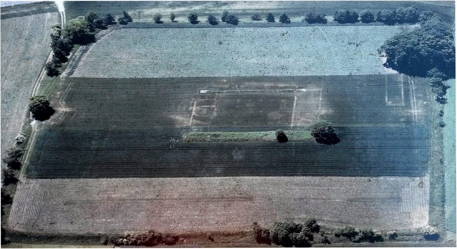
Aerial photographs suggest a granary immediately west of the headquarters. To the east, a complex structure identified by magnetometry, a survey method that detects buried features through changes in soil magnetism, may have been the commander’s residence.
Bathhouse
A bathhouse stood 150 metres southeast of the fort and had frescoed decoration. It was destroyed in 1823.
Later chapel
A rectangular chapel measuring 8 by 12 metres was built within the former multipurpose hall, near its northeastern end. It had a semicircular apse facing east and followed a different alignment from the Roman building.
The civilian settlement and surrounding landscape
Settlement streets and the southern road
The civilian settlement left an open strip about 60 metres wide between its buildings and the fort. A road ran around the fort’s perimeter, with settlement features beyond it. At the northern corner of the outer ditch, this road turned southwest, passed the northwest front, and continued toward the route to Kösching; to the south, it passed the bathhouse. A substantial road also left the southern gate toward the Danube. In the excavated area it was 5.4 metres wide. Its earlier phase, accompanied by narrow, elongated strip houses along the street, may have followed little more than a track. After the road was improved, a ditch up to 1.2 metres wide ran along its eastern side. Pottery from the ditch probably dates to around the middle of the second century.
Buildings, crafts, and wells
Stone buildings stood immediately west of the fort. The civilian settlement included a temple where silver vessels were found, and a pottery workshop was uncovered in its eastern area in the early 1980s. In the older settlement area, deposits beneath a Roman levelling layer included an abandonment layer and cultural material more than a metre thick in places. Finds from the deposits, including fine Roman tableware from central Gaul and Rheinzabern and coins, date from the middle of the second century onward. A wooden barrel well was built between AD 150 and 160; a second well, made with a timber box, dates to AD 220.
Prehistoric enclosures
About 400 metres north of the fort, a prehistoric enclosure lay on a gently west-sloping hillside of fine windblown soil. It measured roughly 60 by 60 metres and had a skewed-square plan surrounded by three parallel ditches, probably pointed in profile. The ditches ran approximately north–south and southeast–northwest. The enclosure is thought to belong to the Hallstatt period, an Iron Age cultural period in central Europe, and to the type of fortified elite farmstead associated with that era. Two Roman stone buildings were later built in succession on levelled ground at one corner: one was nearly square, while the other was elongated and had at least two rooms. Both probably belonged to the civilian settlement. Furrows at the enclosure’s edge may have been clay pits serving a Roman brickworks or pottery workshop.
Geophysical survey inside the fort’s rear sector identified a prehistoric oval enclosure about 40 by 80 metres across, with a double ditch and a nearly north–south alignment. It extended close to the Roman shrine and has been interpreted as a late Neolithic or Altheim-period earthwork; the Altheim culture was a late Neolithic archaeological culture of southern Germany. A later double-ditched enclosure may have incorporated this earlier feature. Its identified northern section included a rounded ditch end extending northwest beneath the headquarters courtyard, and the larger enclosure may have had a skewed rectangular plan. A smaller rectangular enclosure with two ditches lay to its north-northwest. It may have been a Hallstatt-period fortified farmstead and shared a ditch with the larger enclosure.
Burials and archaeological finds
Cemeteries and graves
Burials have been found north of the fort and at a cemetery about 300 metres northeast of it, beyond the civilian settlement on both sides of the ancient road to Eining. The cemetery yielded face urns, and aerial archaeology identified the foundation of a tomb tower near the road in 1979. Excavation in 1977 uncovered a man’s burial with few grave goods in the oldest settlement area; a pit two metres away contained two horse skeletons. A separate group of early medieval graves lies in the southeastern part of the former settlement.
Burial chamber
The burial chamber found in 2016 stood on a rise northwest of Pförring, near the former Roman settlement. It held the remains of a young woman about 1.73 metres tall. Her grave goods included at least seven necklaces made from coral, amber, glass, and metal; bronze brooches; a bone comb; a weaving sword, used to press weft into place on a loom; and a hairpin. Belt fittings included ornamental keys, small containers, tweezers, and a sea-snail shell. Pottery and a glass vase were also placed in the grave.
Military equipment
A depot buried in the civilian settlement during the unsettled first half of the third century contained large bronze fragments from cavalry parade armour, pieces of additional breastplate fittings, other equipment, and remains of two bronze helmets with face masks. These finds are now in the Archaeological State Collection in Munich. A separate discovery made at the fort in 1990 was the upper section of a one-piece bronze greave, or shin guard, dating to the second or third century and decorated with Victory and Mars. It is also held in Munich.
Inscriptions and stone monuments
A limestone plaque fragment linked to the possible honorific inscription for Caracalla once carried gilded bronze letters about nine centimetres high. Other surviving stone monuments include the altar associated with Epona and the Campestres, two gravestones, and a relief depicting Romulus and Remus. The altar is now held in Munich; the gravestones and relief are at the Sebaldus Chapel beside Pförring’s parish church. The inscription recording the fort’s stone rebuilding was found in a field in 1843 and was long set into a wall of Sebastian Church before its restoration in 2012.