Castra of Tokod: A Late Roman Military Fort in Hungary
Site at a Glance
- Popularity
- Very Low
- Country
- Hungary
- Primary era
- Classical
- Eras represented
- Classical, Modern
- Civilizations
- Roman
- Site type
- Military
- Remains
- Fort
On this page21 sections
History
The Castra of Tokod is a Late Roman military fort at Tokod, Hungary, built by the Romans probably between AD 368 and 375 under Emperor Valentinian I, who ruled from AD 364 to 375. It belonged to the Pannonian Limes, Rome’s frontier system along the Danube in Pannonia, but stood about 2.5 km south of the river. Its garrison provided security and surveillance as a rear base for troops stationed on the frontier, rather than guarding the river directly.
Possible early activity and construction
Bricks stamped with the names of Legio XI Claudia and Ala I Flavia Britannica, units associated with the Brigetio area in the early second century, may point to a temporary military post near Tokod at that time. The fort itself was built much later, as part of Valentinian I’s programme of military construction along the Roman frontiers. Stamped bricks and coins support a date between AD 368 and 375.
Thirty-nine bricks bear the mark of Frigeridus, probably Valeria’s senior provincial military commander from about 371 until he was removed from office in 373 or 374. Other bricks carry the mark of Lupicinius, a military tribune, or officer, active after 368 and before 377. Three bricks are stamped with the name of Terentius, Frigeridus’s predecessor.
András Mócsy considered it possible that the fort was not included in the Notitia Dignitatum, a late Roman handbook of civil and military offices, because construction may not have been complete when the handbook was compiled.
The civilian settlement
People lived in the Tokod area during the Neolithic and again in the Late Iron Age, when a Celtic group was present. A civilian Roman settlement developed north-northwest of the fort. It took shape in the first century AD and began to flourish in the first half of the second century. Its growth was aided by the Danube, local springs and building stone, as well as established roads.
The Marcomannic Wars, conflicts between Rome and peoples including the Marcomanni from AD 166 to 180, brought destruction to the settlement. Its buildings were later rebuilt. Pottery-making helped support the population, which produced grey ware now known as Tokod ware. Glassworking may also have taken place there.
Later Roman use and decline
A major fire damaged the fort after Valentinian I’s reign. During the subsequent rebuilding, the floors of the two gate towers were renewed and the small side entrances were provisionally blocked.
Evidence from the fort and a nearby late Roman cemetery led Mócsy to conclude that a small Romanized population remained in the area into the first third of the fifth century. Coins of the emperors Arcadius and Honorius help date this activity. Pottery production was considered important to the community’s survival. Finds linked to the fort and settlement suggest that the Avars, whose polity became powerful in central Europe during the early medieval period, may have destroyed the site. If so, settlement may have continued into the early sixth century.
A settlement arose again in Tokod during the Árpád period, when Hungary was ruled by the Árpád dynasty, but it was not rebuilt after the Mongol invasion.
Archaeological investigation and protection
Roman finds from Tokod were known in the nineteenth century. The first known excavation in the fort area took place in 1894, although it was not documented. Further investigations followed in 1924–1926 and 1959, before Mócsy excavated the fort between 1960 and 1969. Work in the civilian settlement from 1955 to 1965 recorded eleven buildings.
Mining of Tokod’s brown-coal deposits damaged ancient buildings and made some areas difficult or impossible to investigate. A lime kiln was probably built near the fort’s eastern corner, where burning lime from standing masonry caused further damage. Under Hungary’s 2001 monument law, the fort and nearby Roman road are protected as nationally valuable archaeological cultural property. The law also treats the country’s other Limes installations as archaeological sites.
Remains
The fort occupied a low rise that slopes northward, southeast of a crossing on the road running along the Danube. That route linked frontier installations and carried military and commercial traffic. A road from Aquincum, at the site of present-day Budapest, skirted the Pilis Mountains and joined it at the crossing between the forts of Crumerum and Esztergom. Tokod’s irregular four-sided enclosure had a northwest-facing front and a stone defensive circuit.
Fortifications and entrances
Walls, towers, and ditch
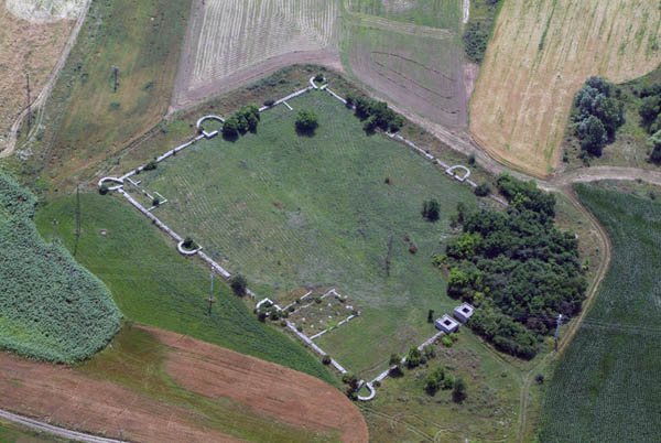
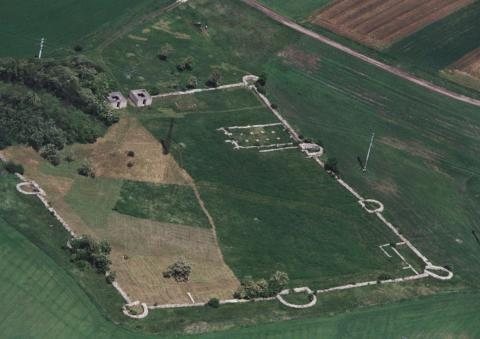
The enclosure measured 122 × 140 × 115 × 145 m, and its walls were about 1.65 m thick. An outer ditch ran around the fort, 21 m from the walls; it was 7 m wide, 2.5–3 m deep, and reinforced along its edges with stone. An oval tower stood at each corner, with curved narrow ends that projected in a basket-handle shape and entrances facing inward. Two U-shaped towers also stood along the flanks. The towers, about 1.1 m thick, were built before the connecting walls, and their floors had terrazzo, a smoothed surface of aggregate set in a binder.
The most massive tower projected in a U-shape from the southeastern rear wall. It stood at the fort’s highest point, 140 m above sea level, where the ground falls almost 10 m toward the north. A central pillar inside supported its roof. The 455 m-high Gete rises immediately south of the fort, while a valley lies to the east. A spring in the valley fed a stream until Tokod’s mining activity dried it up by the late 1970s.
Main gate and side entrances
The main gate, called the Porta Praetoria, faced northwest. Its single-lane entrance was flanked by two rectangular towers built from grey sandstone blocks. A two-step threshold survives in place, made from second- and third-century grave monuments laid with their inscribed faces downward. Wagon ruts worn into the stones indicate prolonged use. A roughly worked reddish marble slab, measuring 0.70 × 0.85 × 0.12 m, came from debris at the gate. It may have served as a door or window lintel; its marble came from nearby Piszke.
Two small side gates faced one another in the side walls. The fort’s rear wall instead carried the projecting U-shaped tower. A curved feature about 115 m long ran from the eastern corner of the nearby late Roman complex toward the north tower of the main gate; it may have been a canal.
Buildings within the fort
Granary
The largest and most substantial interior building was a rectangular granary in the front half of the enclosure, with its short end adjoining the northeastern wall. It measured 15.20 × 24.80/25.60 m. Its foundations extended about 0.60 m deep and used mortar like that in the fortification wall. Eight sandstone-clad pillars, each about 1 × 1 m, stood in two rows and supported a raised plank floor. In a later phase, the northwestern side received thicker masonry and heavier pillars, and its entrance was narrowed. The reason for this reinforcement is unknown; unstable ground is one possible explanation.
Other interior buildings
A building between the eastern tower and northeastern wall was made from small pieces of yellow sandstone. Mócsy associated less robust buildings inside the fort with a later phase, possibly the population that lived there in the fifth century.
Late Roman complex outside the fort
About 100 m in front of the main gate stood a villa-like complex enclosed by an irregular wall around an area of roughly 90 × 100 m. Projecting supports strengthened the western stretches of the wall, which apparently also had one or more towers. The main building, about 35 × 22 m and aligned southwest to northeast, included a large room ending in a rounded recess, or apse. A parallel room to the southeast also ended in an apse; together, the two spaces covered more than 200 m². Two rectangular rooms lay northwest of the central room, while a passage about 4 m wide and 22 m long led northeast to six adjoining rooms. A small excavation investigated the courtyard in 1979, and aerial archaeology in 2007 and 2009 revealed further details, including scattered buildings that may have preceded or followed the complex. Its precise connection with Tokod’s pottery production remains unresolved.
Civilian settlement and production
Buildings and pottery
The settlement extended north-northwest of the fort. At its height it included substantial stone buildings, some with wall paintings, marble fittings, or underfloor heating systems. Many buildings were damaged by mining. The settlement produced large quantities of thin-walled, well-fired bluish-grey pottery known as Tokod ware, also called the Tokod group or Tokod type. Production began in the middle of the fourth century, and late examples came from a soil-leveling layer formed before the fort was built. Green lead-glazed pottery was less common; its production began around 370 and expanded after 378.
Bath and later workshop
Building X, a bath excavated in the settlement area in 1961 by archaeologist Sándor Soproni, may have belonged to an earlier fort used by a Roman cohort, a military unit. Fine tableware from its first-century layers included Padanian and Italic vessels with raised clay decoration. The bath was later converted into a dwelling, remodeled again, and made into a workshop during the fourth century. A coin of Trajan and pottery from the building’s layers helped establish the dating of its destruction. Mining-related wash-off ultimately destroyed the structure.
Cemeteries and other finds
Early Roman cemetery
An early Roman cemetery lay north of the civilian settlement. Two vessels from a cremation burial were found there in 1953. Investigations in 1958 exposed disturbed skeletal graves of uncertain date. A Roman military diploma dated to AD 110 was found east of an old settling basin, near the area investigated in 1958.
Late Roman cemetery
The cemetery on the western side of the ancient settlement was used during the fourth and fifth centuries. Mócsy excavated 115 graves containing 137 skeletons. Twenty-two graves had been reused, with some later burials placed above or beside earlier ones. Clothing, ornaments, a small number of coins, and the placement of grave goods followed local fourth-century and wider Pannonian practices. Some bricks from the cemetery bore military stamps also found at the fort.
Coin hoard
In 1972, a Tokod resident found a clay vessel containing 37 Roman denarii, a coin denomination, on private land. The coins date to the reigns of Antoninus Pius and Marcus Aurelius, but the find’s recorded circumstances do not establish when the hoard was buried.
Preservation
A spoil heap deposited by nineteenth-century mining covers the fort’s western corner. After excavation, the stone remains were largely conserved and sections of the walls carefully reconstructed. By 2012, the two towers of the main gate had a person-height reinforced-concrete overlay. The concrete had begun to break away from its steel reinforcement, and parts of the open, flat-roofed structure had collapsed.