Wyszogród (Bydgoszcz): A Medieval Frontier Stronghold in Poland
Site at a Glance
- Popularity
- Medium
- Country
- Poland
- Primary era
- Medieval
- Eras represented
- Medieval, Modern
- Civilizations
- Kingdom of Poland
- Site type
- Military
- Remains
- Fort
On this page19 sections
History
Wyszogród was a medieval fortified stronghold in the Fordon district of Bydgoszcz, Poland. It stood on the Kuyavia–Pomerania frontier, where it could oversee movement along the Vistula and the via regni, or “royal road.” This land route linked Kuyavia and Greater Poland with Gdańsk Pomerania and the Chełmno region, and also formed part of the Amber Road toward Gdańsk. Its strategic position drew Wyszogród into repeated struggles between Kuyavia and Pomerania.
Origins and early campaigns
A medieval tradition associates Wyszogród with Saint Adalbert of Prague, also known as Wojciech, a tenth-century bishop and missionary. According to the tradition, he stopped there in 997 while travelling to preach to the Prussians, a Baltic people, consecrated a chapel to Mary Magdalene, and baptized local people. A church visitation in 1588 gave a fuller version, saying he stayed with a local lord for several days alongside his brother Gaudentius and a monk named Bogusz. His journey may have taken him past the site, but the tradition does not securely place a stronghold there in the tenth century; a settlement may have occupied the location instead.
The stronghold’s beginnings are also uncertain. It may have been established under Polish control before 1037–1038, or under Pomeranian control after that date, as rulers sought to secure this contested frontier. Some historians link it to an earlier stronghold at Strzelce Dolne. Władysław I Herman’s forces probably burned Wyszogród during a campaign in 1090–1091. The stronghold was then rebuilt and enlarged.
In 1113, Bolesław III Wrymouth captured Wyszogród after an eight-day siege. The medieval chronicler Gallus Anonymous recounts that the defenders surrendered in exchange for a promise of safety. Bolesław then remained for another eight days to strengthen the fortification before departing and leaving a garrison.
The castellany and its revenues
After Bolesław’s conquest of Pomerania, Wyszogród passed to local magnates, probably as part of a broader distribution of lands in the 1130s. Mieszko III the Old granted it to Janusz Wojsławic of the Pował family for his service in the conflict against Władysław II the Exile. Janusz held the territory as an official benefice attached to the castellany, an administrative district centred on a stronghold, rather than as private property. A castellan, the district’s appointed official, administered such a territory.
A document of 1145 records Janusz and his wife Sulisława granting half the income from Wyszogród’s customs duties, inns, and markets to the monastery at Trzemeszno. The same document names a customs station, a market, inns, and the Wyszogród castellany, whose lands extended across the Brda and Vistula basins on both sides of the river. It also confirms that a church was already there. A record from 1198 mentions the church again. The Pował family probably founded it, and it may have served a group of canons, supported by tithes from the family’s villages.
Wyszogród and its lands remained in Janusz’s family until about 1207, then probably passed by inheritance to the Pomeranian dukes. The details are uncertain. Janusz’s daughter may have been the mother of Mestwin I, Duke of Gdańsk, and may have received the castellany as her marriage endowment. From 1188, Wyszogród appears as a Pomeranian castellany.
Shifting control in the thirteenth century
Political control of Wyszogród changed repeatedly as Kuyavian and Pomeranian rulers competed for the region. In 1238, Duke Świętopełk of Pomerania and Duke Casimir I of Kuyavia fought over the area, while the castellany was reorganized. Arnold, an associate of Świętopełk, held the office of castellan that year. A conflict that began in late 1242 brought Wyszogród under Casimir I, who had the support of the Teutonic Order, a Catholic military-religious order that established power in the Baltic region, and the Greater Polish dukes Przemysł I and Bolesław the Pious. In 1256, after the Kuyavian and Pomeranian dukes agreed to cooperate against the Order, Pomerania gave up its claims to Wyszogród and Bydgoszcz.
Trade routes and defenses also figured in these disputes. During a customs conflict with the Teutonic Order in 1250, Casimir I barred his subjects from sending goods north by the Vistula route through Toruń. He directed that traffic instead through Bydgoszcz and Wyszogród. An agreement of 1252 assigned local people responsibility for maintaining the fortifications at both places and noted ducal customs stations there. A permanent bridge at Bydgoszcz suggests that land traffic and trade were increasingly moving toward that settlement.
After 1267, Duke Siemomysł of Kuyavia intervened in a Pomeranian succession dispute and transferred Wyszogród to Warcisław II. When Warcisław was defeated by his brother Mściwoj II, the stronghold and its lands returned to Gdańsk Pomerania. Siemomysł was meanwhile occupied by a revolt in Bydgoszcz in 1268 and was defeated by Bolesław the Pious in 1271. In 1288, Mściwoj II established the smaller Serock castellany from the northern part of Wyszogród’s territory.
Wyszogród hosted several meetings over inheritance and political disputes. In 1280, Siemomysł of Inowrocław and Mściwoj II met at Rzepka, on the boundary between the Wyszogród and Bydgoszcz castellanies. Their agreement provided for Wyszogród to return to Kuyavia after Mściwoj’s death. On 15–16 September 1284, Bishop Wisław of Włocławek met Konrad von Thierberg, the Teutonic Order’s territorial master, at Wyszogród during a dispute involving the brothers Siemomysł and Leszek the Black.
Another meeting took place there on 13 May 1288 to address Mściwoj II’s divorce from Eufrozyna, the widow of Casimir of Kuyavia and mother of Władysław the Elbow-high. The next day, Mściwoj transferred Wyszogród’s territory, apart from Serock and its surroundings, to Przemysł II of Greater Poland in exchange for land in Lesser Poland. After Mściwoj died in 1294, Przemysł took control of Gdańsk Pomerania under the 1282 settlement of Kępno. Following Przemysł’s murder in 1296, Władysław the Elbow-high granted Wyszogród to Siemomysł’s sons, Leszek, Przemysł, and Casimir. They gave up claims to Pomerania through their mother, Salomea, and Wyszogród thereafter remained associated with Kuyavia.
Ducal residence and destruction
In 1314, Siemomysł’s sons divided their inheritance into separate principalities. Duke Przemysł received a Bydgoszcz–Wyszogród principality and issued documents at Wyszogród between 1314 and 1318, indicating that he maintained a residence and chancery there. Officials also lived at the stronghold, although the castellan was based at Bydgoszcz. Przemysł extended his authority over the Inowrocław territory in 1323. When war with the Teutonic Order began in summer 1327, Władysław the Elbow-high took direct control of most Kuyavian principalities, while Przemysł received the Duchy of Sieradz.
The Polish–Teutonic War of 1327–1332 brought Wyszogród’s destruction. Its garrison had grown to about 200 armed men and used the stronghold as a base for attacks on Teutonic ships on the Vistula. In spring 1330, a force led by Otto von Lauterberg, commander of Chełmno, besieged it. The attackers took the stronghold on 12 May after several assaults and set it alight. Defenders died in the fire, and treasure deposited there by local landowners was destroyed. The Teutonic force then demolished and burned the stronghold, settlement, and church, and threatened surviving residents with death if they rebuilt the fortification.
A truce on 18 October 1330 returned Bydgoszcz and Wyszogród to Władysław the Elbow-high. During a renewed Teutonic campaign in July 1331, only Bydgoszcz was recorded as captured; Wyszogród was too badly ruined to hold a Polish garrison. The region remained under Teutonic occupation for six years. After its conditional return to Poland in 1337, Casimir III the Great made neighbouring Bydgoszcz the principal centre. He established a castle, town, and starosty, an administrative district governed by a royal official, incorporating the former Wyszogród and Bydgoszcz castellanies and the territory of Tuczno.
Settlement after the stronghold
Settlement continued around Wyszogród after the fortification was destroyed. The village and parish survived, and clergy from Wyszogród appear in records from 1349, 1375, and 1382. In 1349, Duke Casimir of Słupsk endowed the rebuilding of the parish church, which served Fordon until about 1430. Fordon succeeded Wyszogród as the local urban centre. Władysław, Duke of Opole, granted it a charter in 1382, and King Władysław Jagiełło chartered it again in 1424. Fordon became part of Bydgoszcz’s urban area in 1973.
Wyszogród village survived until the middle of the fifteenth century. By about 1500, its land had become open fields owned by people from Fordon. The old church was abandoned in the fifteenth century and fell into complete ruin in the second half of the sixteenth century; at one point, its remains served as an animal enclosure. Around 1591, Fordon parishioners built a new wooden church with the same dedication for occasional services. The old church’s endowments and income had passed to Fordon’s Church of St Nicholas. The wooden building had itself fallen into ruin by the time Fordon came under Prussian rule in 1772. Documents called the surrounding earthworks “Wyszogród hills” and “ramparts,” and by the late eighteenth century they were also known as “Swedish ramparts.”
Remains
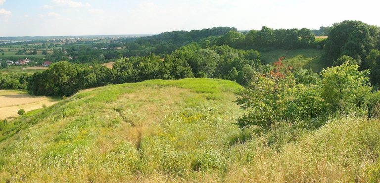
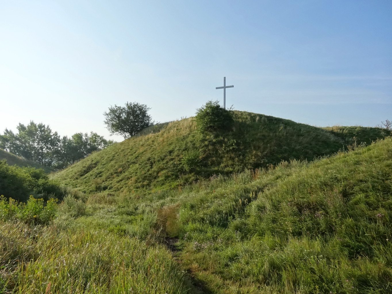
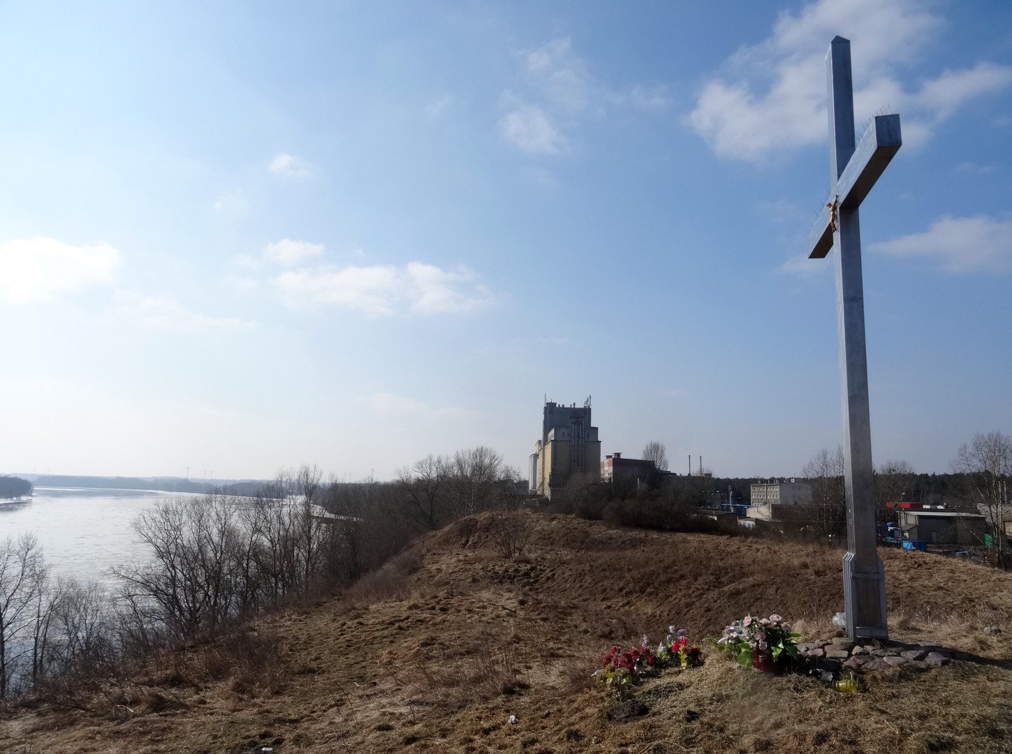
The surviving earthwork occupies a terrace on the steep left bank of the Vistula, where the river cuts into higher ground. Its summit is about 50 metres above sea level and 22 metres above the river. The site lies within Fordon, about 1.5 kilometres northeast of the Brda’s mouth. River erosion has reduced the stronghold to roughly one-fifth of its former extent. Its remaining earthwork measures about 190 metres across and has two high points.
Earthwork and defenses
Surviving form
The visible defenses include an outer rampart that rises 3–4 metres above the surrounding ground, compared with an estimated original height of 5–6 metres. A surviving section of the inner rampart is about 35 metres wide. A dry ditch, 10–28 metres wide and 6 metres deep, and an entrance on the north complete the features described at the site. Excavation-based estimates indicate that the rampart retains about two-thirds of its former height. The stronghold once stood directly beside the Vistula, which has cut into the bank beneath it. A timber port built at Brdyujście in 1879 shifted the river’s current north and accelerated erosion; later river regulation and reservoirs, including the Włocławek reservoir, halted the process.
Fortification phases
The earliest stronghold was circular, about 130 metres in diameter, with a single ring of timber-reinforced earth rampart around five metres high and a ditch about five metres deep. A clay core was protected by timber walls, while stones strengthened the northern side. Thick beams formed a timber framework along the rampart’s inner face. The earliest material from the site dates no earlier than the middle of the eleventh century.
After rebuilding, the fortification measured about 148 metres across and covered a reported 1.7 hectares. A further rampart extended the defenses outward, bringing the diameter to nearly 180 metres and forming two defensive rings. The timber-and-earth works were as much as 25 metres wide at their base and had an outer stone facing. They may have remained open toward the Vistula. In the first half of the thirteenth century, builders strengthened the ramparts with timber boxwork, a wooden framework filled with clay, and added an inner ditch that divided the stronghold into two parts.
The eastern section, about 90 metres across, stood higher and served administrative and military purposes. The lower western area was used for sleeping and domestic activity. Weapons dating from the twelfth to fourteenth centuries are concentrated more heavily in the eastern part.
Buildings and finds within the stronghold
Domestic and defensive structures
Excavations revealed an occupation layer, the accumulated deposits of settlement, between 2.5 and 4.5 metres thick. It contained traces of log-built huts, pits, and hearths used for household and productive work. The deepest deposits included remains of five dwellings, represented by floorboards and other material; their earliest contents date no earlier than the mid-eleventh century. Medieval records also describe a masonry defensive building from the mid-thirteenth century, perhaps in the southeastern part of the stronghold, an area now lost to the river.
Excavated materials and daily work
Investigations in 1958–1960 recovered more than 600 artefacts, around 35,000 pottery fragments, and tens of thousands of bones from domestic and wild animals. Finds related to farming, fishing, hunting, and craft production include scythe fragments, iron sickles, fishing rods, nets, harpoons, beaver jaw fragments, and deer antlers. Horn, bone, metal, wood, and clay objects, along with iron chisels and drills, show a range of household and workshop activities. Other objects include nails, amber raw material, knives, whetstones, needles, awls, shears, locks, fire strikers, and clothing fittings.
Personal objects include amber beads, horn combs, and bronze bracelets decorated with patterns associated with the medieval East Slavic lands, or Rus’. The bracelets date from the eleventh to thirteenth centuries. A 1932 investigation found thick oak beams within a rampart, with pottery fragments, worked horn, and fish scales. An 1886 examination described a layer of gray soil and burnt material over clean yellow sand in the rampart, with stones strengthening its northern core.
Weapons and horse equipment
Military equipment includes about 60 arrowheads and crossbow bolts, chain-mail rings, three iron spurs, three bits, and four horseshoes, as well as fragments of others. A double-edged sword with a broken blade, dated to the twelfth century, was found about 100 metres from the stronghold while the Vistula slope was being graded in the 1960s. Its findspot may have been near a crossing used by Bolesław III’s forces.
Settlement, cemetery, and church area
Northwestern settlement
Excavations northwest of the stronghold, carried out from November 2012 to April 2013 across 1,100 square metres, identified 65 features, 35 of them containing early medieval material. Storage and production pits were among the finds, while timber-beam impressions extending for several metres may mark a road leading west from the stronghold. The excavated area was not occupied intensively in every period and appears to have been peripheral in the thirteenth and fourteenth centuries. Its pottery included 1,710 sherds from early medieval deposits and features. Wheel-finished vessels, apparently fired in open fires, were decorated with grooves, wavy lines, and incisions; four bases carried raised Greek-cross marks. The pottery dates from no earlier than the mid-eleventh century, while finds from this area point to use from the late eleventh to late twelfth century.
Objects from the northwestern settlement include an eleventh-century coin called a denar and a lead weight associated with trade. Other finds include iron buckles, a cross-shaped bronze-alloy pendant from an eastern Slavic workshop, iron knives, a needle, a spindle whorl, a crossbow bolt, and a bone object associated with recreation.
Northeastern cemetery and building
In 2013, excavations northeast of the stronghold near the Vistula escarpment exposed a cemetery with 54 graves dating to around the turn of the twelfth and thirteenth centuries. Some burials contained ornaments or coins placed in the mouth. The same work uncovered the remains of a large building dating to the second half of the twelfth century. It had two storeys and a basement, and yielded knives, iron needles, and bone tools. It may have served as an inn or customs station.
Church and older burial ground
A 1932 excavation found six human skeletons several dozen metres northeast of the earthwork. The old church stood near the stronghold beside the Vistula, with an older cemetery and an ossuary, a place for storing human bones, nearby. A separate excavation in 2012 explored 300 square metres and uncovered settlement buildings from the eleventh and twelfth centuries, together with a small amount of later medieval material.
Commemorative cross
A cross installed on the northeastern summit on 22 June 1997 commemorates the millennium of Saint Adalbert’s traditional mission to Prussia. It also recalls the medieval account that he stopped at Wyszogród and consecrated a chapel to Mary Magdalene.