Castrum Tibiscum: A Roman Frontier Fort and Settlement in Dacia
Site at a Glance
- Popularity
- Medium
- Country
- Romania
- Primary era
- Classical
- Eras represented
- Classical
- Civilizations
- Roman
- Site type
- City
On this page22 sections
History
Foundation and frontier garrison
Castrum Tibiscum was a Roman auxiliary fort, military settlement, and civilian town near present-day Jupa in Romania. The first fort was probably established between AD 101 and 106, during Emperor Trajan’s campaigns to conquer Dacia, a Roman province in the region of present-day Romania. Tibiscum occupied a strategic point in the province’s frontier system, where two major roads met. One route linked the Danube frontier with Sarmizegetusa by way of Viminatium, Lederata, Arcidava, and Bersobis; another connected Drobeta and Dierna with Sarmizegetusa. The garrison guarded the junction and nearby roads, monitored movement, and watched settlements in the surrounding hills.
The earliest fort may have followed the first Dacian War, although a Roman post could have existed there earlier. A violent fire destroyed the first fort, possibly during the Dacian capture of the Roman commander Longinus. A larger timber-and-earth fort replaced it. Among its troops was Cohors I Sagittariorum, an auxiliary cohort, or unit recruited outside the legions, of archers. It began with about 500 Syrian infantry and later numbered as many as 1,000 men. During Hadrian’s reign, archers from Palmyra, an ancient city in Syria, also served at Tibiscum.
The replacement fort burned around AD 118, probably during conflict with the Sarmatians. After Roman control was restored, the fort was rebuilt with stone defenses and timber buildings inside. In AD 118–119, Quintus Marcius Turbo, an equestrian governor and military commander, received honors at Tibiscum and Sarmizegetusa for helping defend the province against the Sarmatians. An inscription found at Caransebeș commemorated the restoration of peace and order.
Expansion and municipal growth
During the later second century, renewed military and political unrest brought substantial expansion to the fort, extending it westward and southward. Unrest under Antoninus Pius led to further changes, and attacks by the Marcomanni and Quadi, Germanic peoples, and their allies between AD 167 and 170 may have caused severe damage. The garrison included Cohors I Sagittariorum, smaller auxiliary formations known as numeri, including Numerus Palmyrenorum Tibiscensium and Numerus Maurorum Tibiscensium, and Cohors I Vindelicorum civium Romanorum milliaria equitata. The last was a thousand-strong auxiliary cohort associated with Raetia, a Roman province in the Alps, and remained at Tibiscum until the Roman withdrawal from Dacia. A detachment from Africa and Mauretania also appears in the garrison record. Associations with Legio IV Flavia Felix and Legio XIII Gemina are less certain; probably two units were stationed at Tibiscum at a time for much of the Roman occupation.
The Severan period, the era of Septimius Severus and his dynasty, brought economic prosperity and the construction of major monuments. Honorific inscriptions were dedicated to Caracalla and Geta, the sons of Septimius Severus who also held imperial power. Tibiscum’s civilian community probably became a municipium, a chartered Roman town, under Septimius Severus or Caracalla. An inscription confirms that status by the reign of Gallienus, AD 253–268. The grant marked a late stage in the urban development of Roman Dacia.
Trade and local production made Tibiscum an economically important town in the Dacian provinces, especially during the third century. Its inhabitants included Dacians, veterans, soldiers, and settlers from across the empire, among them people from Raetia, Palmyra, and North Africa. Roman gods were worshipped alongside deities associated with soldiers’ places of origin, including Malakbel and Bal from Palmyra. Tibiscum also became a regional Christian center and bishopric after AD 313, and is regarded as one of the starting points for Christian mission in Dacia.
Late Roman and medieval settlement
Raids and political instability damaged parts of the civilian settlement during the third century, although some buildings were rebuilt. The Roman army and administration withdrew from Dacia under Aurelian, around AD 271–275. Some residents appear to have stayed at Tibiscum, where buildings were adapted for simpler uses; no destruction at the site is directly associated with the withdrawal. The town continued to function as a Roman municipium during the fourth century and maintained close ties with the empire. It formed part of a short-lived frontier system restored under Constantine I.
Gothic and Alan invasions beginning in AD 375, followed by Hunnic incursions, had severe consequences for Dacia. The decline of urban life in the region probably contributed to Tibiscum’s abandonment in the sixth or seventh century. Roman building materials were reused from around the tenth century. A bishopric called Dibiskos, mentioned around 1020, may have continued the earlier settlement, though that link is uncertain. By the twelfth century, the former Roman site had become part of a medieval town centered on a fortress first mentioned in 1289.
Rediscovery and protection
The ruins were recognized as Roman in the nineteenth century by historian Konrad Mannert. Trial excavations began in 1875 on the right bank of the Timiș, encouraged by cleric and historian Tivadar Ortvay. George G. Mateescu carried out more systematic work in the large stone fort in 1923–1924. Excavations from 1965 to 1989 explored the forts, military settlement, and Apollo sanctuary. Later investigations identified remains of a third fort and examined its defenses, while work at Obreja in 2001 uncovered parts of a fort’s defenses.
Excavations on the left bank were designated an archaeological protection zone in 1977. Tibiscum is protected as a Romanian historic monument under the 2001 law on historic monuments. In 2024, it became part of the UNESCO World Heritage property “Frontiers of the Roman Empire – Dacia,” which includes 277 sites.
Remains
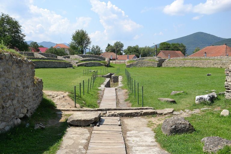
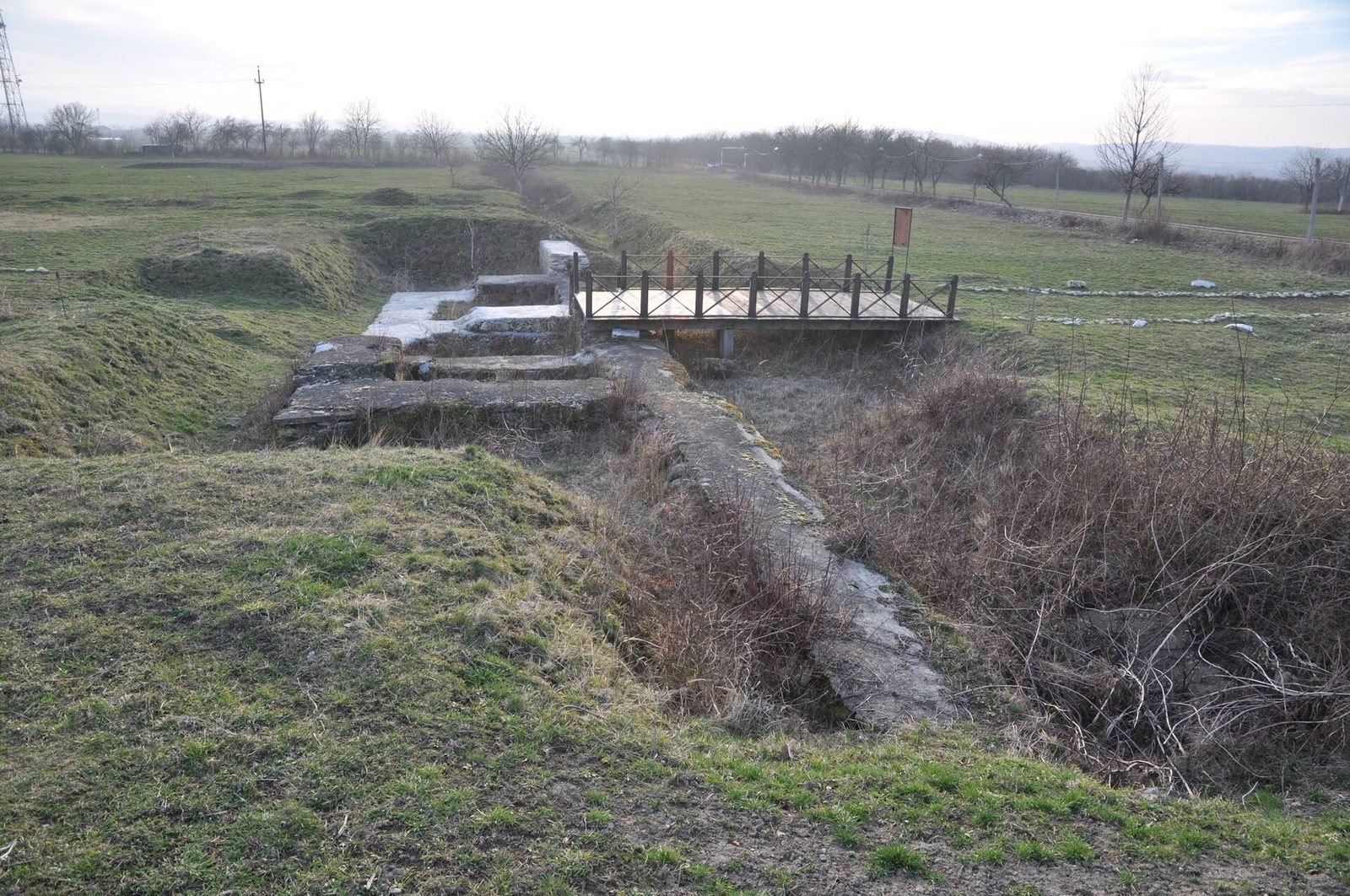
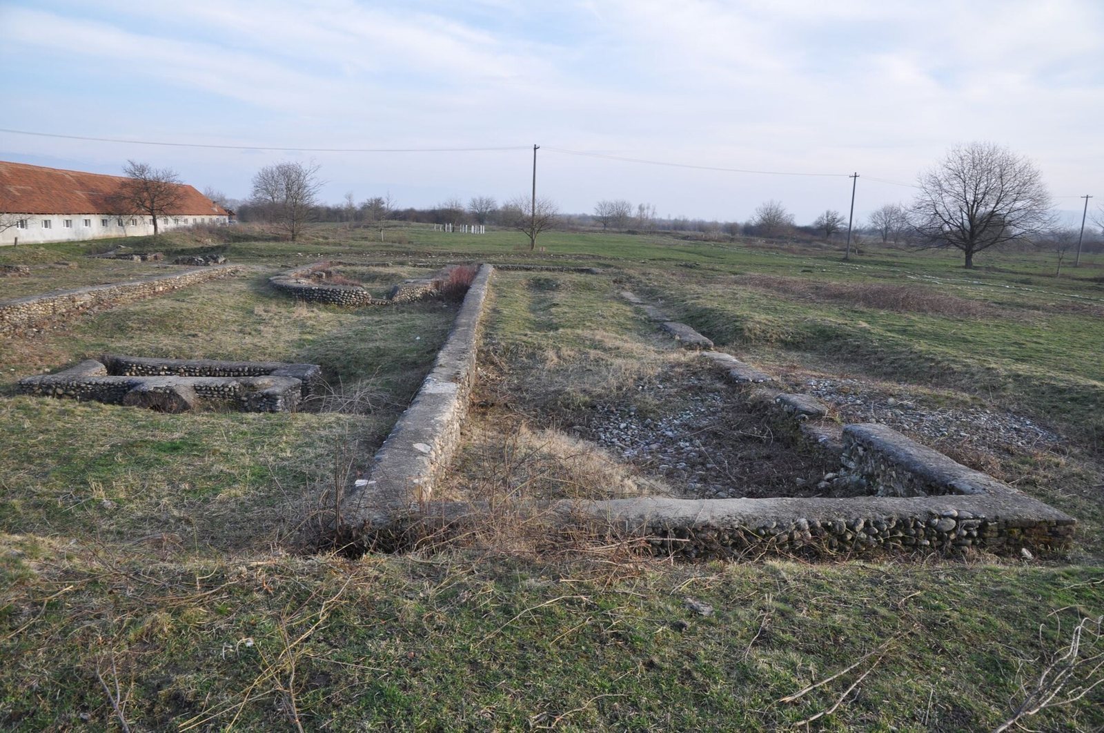
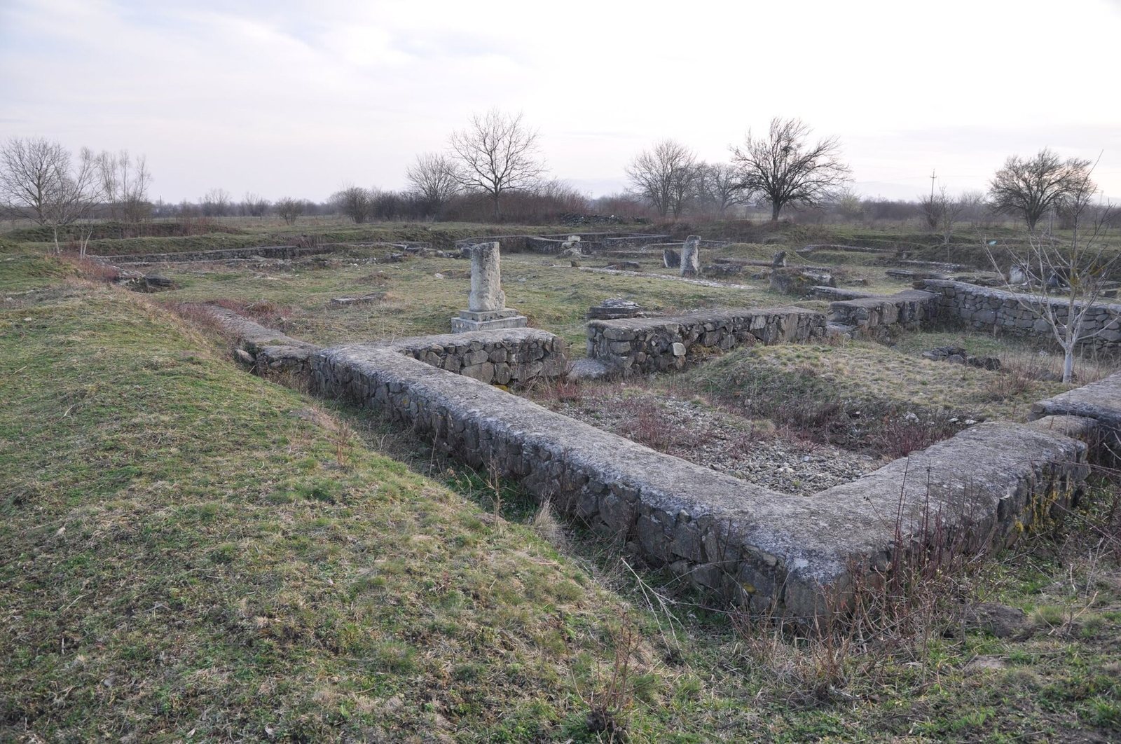
The archaeological complex covers about 27 hectares across the present-day districts of Jupa, Iaz, and Ciuta in Caransebeș. The fort occupied a low terrace on the left bank of the upper Timiș, about two kilometers southeast of Jupa; the civilian settlement lay mainly across the river on the right bank. The river, a tributary of the Danube, has eroded part of the settlement. The remains include successive timber-and-earth and stone forts, a military settlement, a civilian town, and a sanctuary. Two sides of the stone fort’s earthworks survive as raised ground, and some foundations in the military settlement have been conserved.
The forts
Timber-and-earth forts
The earliest fort was probably a square enclosure about 60 meters on each side. Its remains lie in the northeast corner of the later large stone fort, around 1.8–2 meters below the present ground level. Along its southern side, excavators found a defensive bank about six meters wide and 1.2 meters high, together with two ditches and traces of an earth rampart.
The second fort covered about 1.11 hectares and measured roughly 100 meters on each side. Builders leveled the earlier fort, raised the ground by 25–30 centimeters, and extended the defenses beyond its rampart. The new earth bank was five meters wide and fronted by two ditches. Gates flanked by timber towers stood on each side. The eastern entrance was 3.9 meters wide, with square towers 2.4 meters across, supported on wooden beams. Their woven-branch walls were coated with clay mixed with straw. The southern gate, excavated in 1984, was 3.25 meters wide, with square towers 2.55 meters across. The northern passage was about three meters wide, and a square tower measuring 2.4 meters on each side stood at the northwest corner.
Buildings within both early forts were made of timber. Barracks probably ran east–west beside the main camp road. A gravel-paved road, 3–3.1 meters wide, followed the inside of the rampart. A third timber-and-earth fort, probably dating to the middle of the second century, stood south of the large stone fort. It measured 89 by 107 meters, with rectangular towers flanking its southern and eastern gates. The western wall of the later large fort enclosed part of it.
Small stone fort
In a stone phase of the fort, builders added a 3.25-meter-thick stone facing to the outside of the earlier earth rampart. Its foundation used two layers of river stones topped with mortar, and its wall was built from dressed limestone blocks. Stone gate towers measured 4.2 meters on each side, while the width of the gate passage remained unchanged. Timber buildings were rebuilt on their earlier sites inside the defenses.
Large stone fort
The later fort expanded the earlier defenses to the west and south. It formed a trapezoid with rounded corners, slightly skewed toward the northwest, and measured about 195 by 310 meters. Its southern side was destroyed, limiting reconstruction of its full outline. High groundwater required special treatment of the foundations. An inner earth bank, about 5.5 meters wide, stood behind an outer wall 1.5 meters thick. The wall consisted of irregular rubble set in mortar over a river-stone foundation and incorporated inscriptions dating to the reign of Gordian III.
Gates and towers
The main eastern gate was 7.5 meters wide, with two passages, each 3.9 meters across, divided by a central pier. Its solid limestone towers had internal dimensions of 5.1 by 3.4 meters, and a drain ran through the southern passage. The western gate had a 3.9-meter-wide passage between two slightly projecting square towers, each measuring 7 by 5.8 meters. The northern gate was retained from an earlier phase; its passage was 3.25 meters wide, with towers measuring 3.1 meters internally on each side. The fort’s corners were probably strengthened by inward-facing trapezoidal towers.
Headquarters complex
The separately investigated headquarters building had three phases. It was rectangular, measured 35 by 45 meters, and faced east. Its entrance opened into a roofed, colonnaded courtyard measuring 15 by 27 meters, with rooms along its northern and southern sides. Two parallel stone foundations each supported four column bases, measuring 1 by 0.8 meters. In a later phase, the entrance was narrowed and three square stone bases were added along each line of gate supports, probably for altars or statues.
Covered passages led from the courtyard to a transverse hall measuring 8 by 45 meters. Its floor stood about 20–30 centimeters above the courtyard level. Five rooms on its western side included a central sanctuary for military standards and an imperial statue. A cellar beneath this room held the garrison’s pay chest. Rooms beside the hall may have stored weapons; two rooms to the left of the sanctuary served as offices, while those to its right were used by standard-bearers who administered unit finances. A brick altar set into the floor of the westernmost room was found with animal bones and ash nearby. An inscription from the headquarters records Cohors I Sagittariorum’s dedication to Marcus Aurelius in AD 165.
Other interior buildings and roads
Excavated buildings in the large fort date to the second century. In its northeast corner, Building I stood about 6.4 meters from the fort wall. It measured 28.8 by 6.8 meters and had two rooms; it has been interpreted as quarters for officers serving with Palmyrene soldiers and may date to the reign of Septimius Severus. Building II, two meters to its west, ran north–south and had three rooms. It may originally have been a single room with a curved end, and its purpose is uncertain; it may have served as a weapons store or administrative building.
Building IV measured 34 by 6.4 meters and contained seven rooms, some of which may have served as barracks. Buildings I, II, and the northern end of Building IV may have formed part of the headquarters complex. Some buildings in this area had underfloor heating, a system that warmed rooms from below, and may also have served religious purposes. The layout may have functioned as a formal military gathering and administrative area influenced by eastern Mediterranean traditions. The fort’s bathhouse stood in its forward zone and was partly excavated in 1924. A section of the 4.5-meter-wide rear camp road was identified behind the headquarters.
The military settlement
Streets and houses
The military settlement, known as a vicus, meaning a community that grew alongside a fort, lay north of the defenses. At its greatest extent it may have covered about 12 hectares, although the Timiș has erased part of the area. Buildings followed major roads, and small colonnades sometimes lined their street fronts. Most houses were long, narrow buildings; their plots may also have contained vegetable and fruit gardens. Eleven buildings were excavated, but Building II was the only one fully investigated.
Fires repeatedly damaged the settlement, including around AD 118 and in AD 158–159, and buildings were reconstructed afterward. Toward the end of Hadrian’s reign, most houses were demolished and rebuilt in stone. Later rebuilding changed their plans; recorded building widths range from 9 to 14.4 meters. After the Roman withdrawal, new interior partitions were added in Buildings II, III, VII, VIII, and X. These walls were about half a meter wide, made from river stones, and laid on rubble with little mortar. The rooms contained mainly low-quality provincial pottery.
Workshops and community buildings
Building X contained workshops for pottery, glass, and jewelry. Building VII was the most fully representative structure identified in the military settlement, and a marble household shrine was found there. Buildings II, VII, and X had underfloor heating. Building III may have been a shrine; finds from it included an oversized head of Jupiter and part of a dedication column.
The civilian town and Apollo sanctuary
Apollo sanctuary
A temple of Apollo stood about three kilometers east of the fort. Its simple plan resembles that of the sanctuary archaeologists call the Temple of the Moorish Gods at Micia. The Tibiscum sanctuary has been only partly excavated. An inscribed tablet with projecting side handles, found at Iaz in 1982, measured 87 by 75 by 30 centimeters and commemorated the restoration of a sanctuary for the welfare of Septimius Severus and his sons. Marble fragments of a second dedication to Apollo, dating to Caracalla’s reign, were found later. Another dedication, made in AD 212–215 by a unit under the tribune Publius Aelius Gemellus, invoked Apollo as Caracalla’s protector. An inscription also records the sanctuary’s restoration by tribune Septimius Diomedes under provincial governor Octavius Julianus.
Inscriptions, crafts, and finds
Inscriptions and writing
More than 90 inscriptions have been found at Tibiscum, including 60 funerary inscriptions. One dedication to Jupiter Optimus Maximus names a resident, Iulius Valentinus. A damaged third-century marble inscription from the fort records a dedication to Minerva and the protective spirit of Numerus Palmyrenorum Tibiscensium. Bone and bronze writing implements, as well as letters scratched into pottery and bricks, provide further evidence of writing.
Pottery, glass, and metalworking
Pottery was made in both the military and civilian areas. Two large civilian pottery workshops date respectively to the second century and the third or fourth century. They produced everyday vessels and imitations of fine Roman red-slipped tableware, as well as building materials, clay pipes, lamps, and figurines. A lamp-maker named Aurelius is identified by a workshop mark, and an amphora handle carries the name Marcus Syrus.
Glass workshops west of civilian Buildings I, II, and VII made containers and glass beads, with production continuing into the fourth century. A smithy about 25 meters north of the fort dates to the first half of the second century. Another workshop produced military equipment such as buckles, fittings, and horse gear. A separate jewelry workshop from the Severan period made items including an enamel-decorated disc brooch. After a fire, its nearly complete tool set was recovered, including small crucibles with traces of gold. Other workshops worked bronze, silver, and gold.
Other finds and the surrounding countryside
Finds include locally made pottery in Dacian styles, 15 late-Roman clay lamps with eagle-shaped handles, and imported and locally worked metal goods. A hoard of 971 coins was discovered in 1925, and more than 50 additional coins came from the civilian settlement. Roman-period dedication reliefs most often depict Jupiter, Diana, and Mercury.
Several rural villas have been identified near the fort, at Caransebeș, Mahala, Campul lui Cornean, and Iaz. Animal bones indicate that livestock raising, especially cattle and sheep, contributed to the surrounding area’s economy; pig remains are less common.