Castra of Buch: A Roman Frontier Fort in Germany
Site at a Glance
- Popularity
- Medium
- Country
- Germany
- Primary era
- Classical
- Eras represented
- Classical
- Civilizations
- Roman
- Site type
- Military
- Remains
- Fort
On this page21 sections
History
The Castra of Buch, also known as Rainau-Buch, was a Roman fort in Germany, established around AD 130–140 as a garrison on the Raetian frontier. This frontier formed part of the Upper Germanic-Raetian Limes, Rome’s frontier system in the region. Buch’s position helped the Romans watch the Jagst valley and keep an important river crossing within their territory.
Foundation and frontier service
Buch may have taken the place of the earlier fort of Opia at Oberdorf am Ipf, which stood on the Alblimes, a Roman frontier line along the Swabian Alb. The garrison at Opia may have moved to Buch as the frontier advanced. Buch was under the authority of the commander of an auxiliary cavalry regiment based at Aalen.
The force stationed at Buch is generally thought to have been a mounted cohort, a Roman military unit combining infantry and cavalry. One estimate places its strength at about 756 soldiers, including 128 cavalrymen; an alternative estimate of 480–500 assumes an infantry-only cohort and six barracks. Finds connected with cavalry support the mounted interpretation. A road linked Buch with Aalen, while other routes are thought to have connected it with Halheim and the former fort at Oberdorf. An eastbound route passed the Limes gate at Dalkingen toward Germania Magna, the Roman name for lands beyond the imperial frontier in central Europe. Iron ore extraction and smelting also took place in the area.
The civilian settlement
A civilian settlement, or vicus, began developing beside the fort around AD 161. The oldest excavated building timbers had been felled by May or June of that year. Timber from the frontier palisade at Schwabsberg was cut in late AD 165 or possibly in spring 166. Jewellery and other finds suggest that the settlement became prosperous, perhaps in part through trade with Germanic communities.
The settlement was reorganized in AD 193, when some buildings were cleared and plots replanned while the streets remained in use. In the early summer of AD 254, a Germanic attack probably set the settlement ablaze. Residents had hidden valuables, household goods, and military equipment in wells. The attackers may have withdrawn after the fire or been driven away.
Settlement continued after the destruction. Later levelling and building activity, including ironworking, show that the site was not abandoned immediately. A glass fragment and late Roman coins point to activity into the fourth century. The fort’s military role, by contrast, had ended by AD 260 at the latest. Its bathhouse may have remained in use into the early fourth century.
Rediscovery and investigation
Walls still enclosed fields at Buch in 1818, when stone was taken from them for road construction. The first scientific excavations followed in 1897 and examined the defences, gates, towers, stone buildings, and bathhouse. Work between 1969 and 1974 investigated sections of the frontier and its towers. The south gate and nearby defences were excavated and conserved in 1972, followed by renewed work at the bathhouse in 1975–76.
Emergency excavations in 1976–79 explored the eastern and southeastern settlement before rerouting of Federal Highway 290 destroyed that area. Further buildings were excavated in 1979–80, and geophysical surveys and later reassessment of the building timbers refined the settlement’s chronology. The valleys around the fort were partly inundated when the Rainau-Buch reservoir formed in 1982. Since 2005, Buch and associated remains have formed part of the UNESCO World Heritage property of the Upper Germanic-Raetian Limes. The site is also protected as a cultural monument under Baden-Württemberg law.
Remains
The fort and its defences
Setting and enclosure
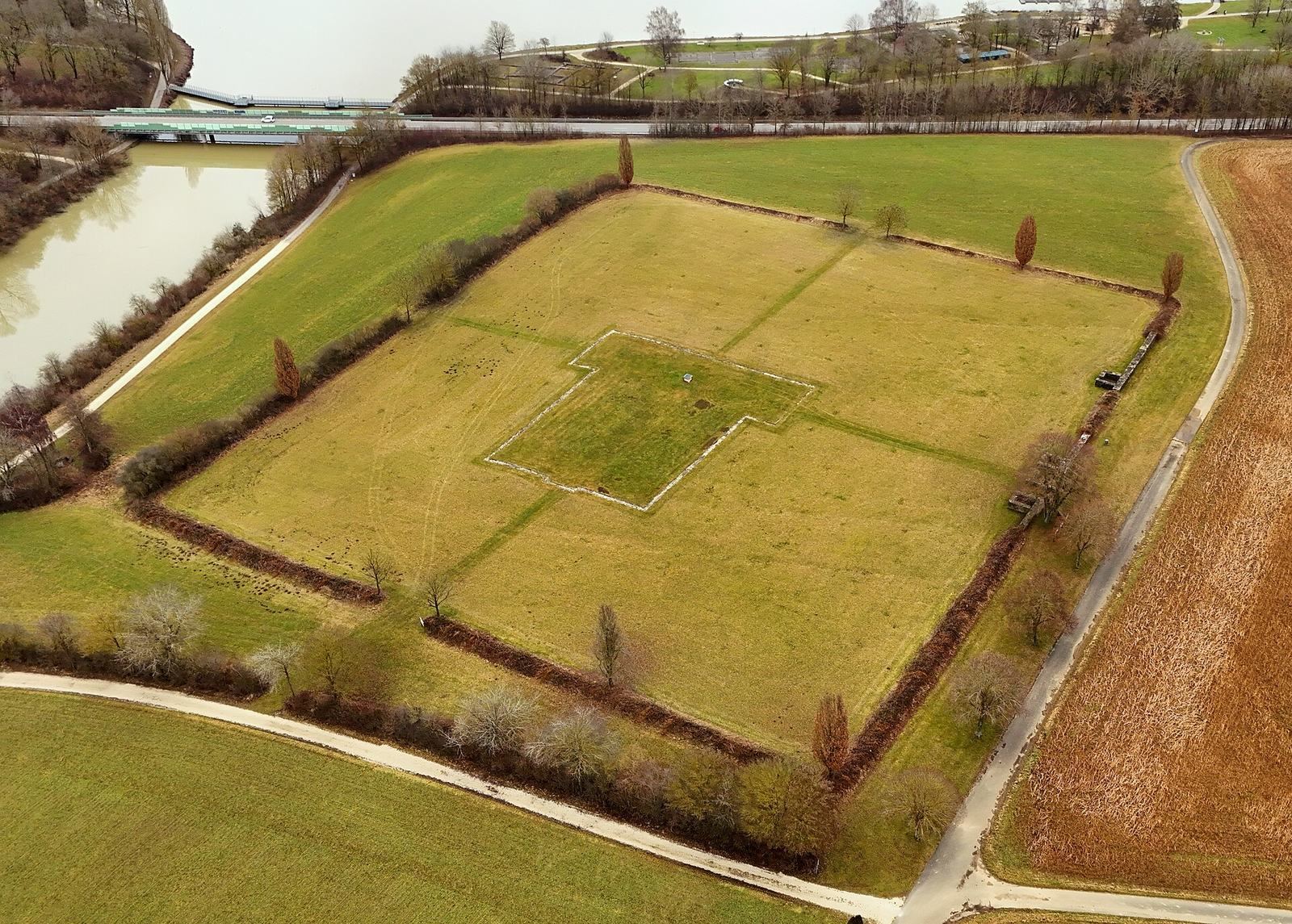
The fort occupies a spur between the Jagst and Ahlbach valleys, with the Langenbach valley along its western side. The Ahlbach runs along the north of the site toward the Jagst, which approaches from the southeast before turning north. The reservoir now covers parts of the surrounding valleys, and remains of ancient buildings have also been found across the Jagst. The fort itself was a roughly rectangular stone enclosure of about 2.1 hectares, aligned nearly north–south and east–west and sloping gently down to the north. Its east-facing front looked toward the Jagst valley. The enclosure measured about 151 metres along its north side, 149 metres along the south, and 139.5 metres along each of the other sides. Its walls, about 1.2 metres thick, were built from local Lower Jurassic sandstone.
Gates, towers, and ditches
The enclosure corners were rounded, with a tower built against each one. Each of the four sides had a two-lane gate divided by a central pier and flanked by towers; the two passages at the excavated south gate measure 4.00 and 4.30 metres across. Eight further towers stood between the corner towers and gates. A three-metre-wide earthen ramp ran along the inside of the wall, interrupted at gates and towers. Soldiers could patrol it behind a stone parapet, while posts along its inner edge helped hold it in place.
Four rounded-corner ditches formed the outer defences, with at least partial breaks at the approaches. The innermost was 5.65 metres wide, the next was two metres wide, and the outermost exceeded ten metres in places. Their centre lines were about ten metres apart. At the east-facing main gate, a wooden bridge crossed the two middle ditches. A crossing may also have connected the inner pair at the northern side gate. The evidence leaves uncertain whether all four ditches were in use at the same time.
Headquarters
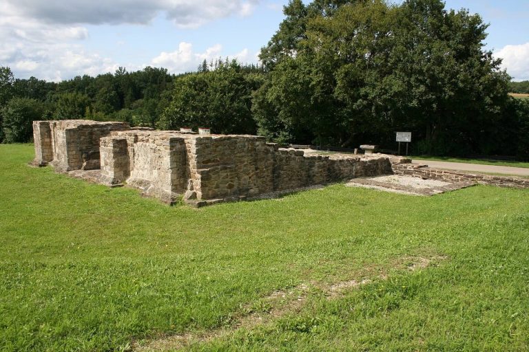
The fort’s main roads met at its headquarters, the principia, which served administrative and military purposes. Its entrance hall was 46.6 metres long and stood over the north–south road. It had an entrance at each end and three more along its long side. Administrative rooms and possible armouries surrounded an almost square open courtyard with a well slightly southeast of its centre. A shrine for the unit’s standards projected from the east side of the building. Today, a gravel strip marks the headquarters’ outline, with a model at a scale of 1:200 set within it.
Granary, barracks, and commander’s residence
A large rectangular stone granary stood just north of the headquarters. Its wooden floor rested on piles, and six rows of postholes survive. Magnetometer surveys traced long timber barracks in the forward part of the fort, aligned north–south and rebuilt at least once. Officers and soldiers may have occupied rooms at their ends. Two large double barracks in the rear measured about 49 and 53 metres long and may have housed horses. Other traces suggest manure pits. Simple barracks stood on either side of the main east–west road, while buildings along the north–south road were arranged as pairs.
Aerial photographs identified a foundation south of the headquarters as a possible location for the commander’s residence, known as a praetorium. The feature has not been excavated. Near a forward intermediate tower, a wall about 15 metres long ran parallel to the defences beside the internal perimeter road.
Arms and other interior finds
A large group of weapons found near the wall may have come from an armoury or may represent a deposited hoard. It included a long cavalry sword and about 1,600 weapon pieces, at least 800 of them iron projectile points, with the remainder comprising arrowheads and spearheads. Other military finds from the fort include fragments of iron and bronze mask helmets used in cavalry tournaments. A bronze sheet from the headquarters, bearing a human head flanked by snakes, is interpreted as part of a shield boss. A room in the northwest corner of the headquarters yielded a helmeted head of Minerva, the Roman goddess associated with wisdom and crafts. A well near the northwest corner, between the perimeter road and the earthen ramp, survives to a depth of 0.60 metres.
The bathhouse
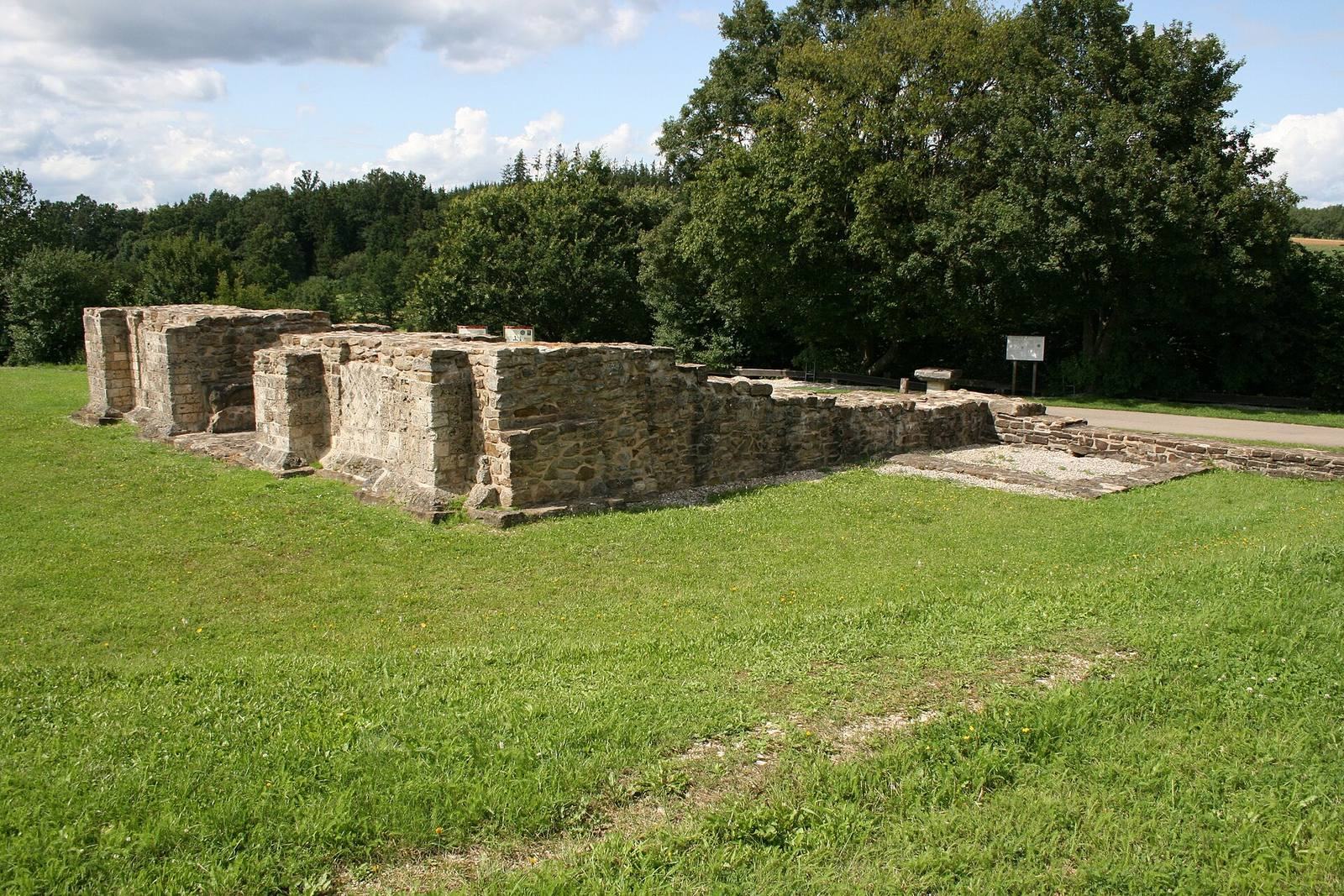
The bathhouse stood about 100 metres northeast of the fort’s northeast corner, near the meeting of the Ahlbach and Jagst, and served civilians as well as soldiers. It followed a nearly north–south axis and a row arrangement of bathing rooms, with a roughly symmetrical plan. Its entrance was on the west or south. The building passed through four construction phases, and its central unit was originally about ten metres wide.
In the first phase, probably not long after the fort was built, visitors entered an unheated changing room from the west and passed into a larger unheated hall. A cold room lay to the east; to the north were two warm rooms followed by a hot room, with a small bathing pool against its west wall. Heating came from the north. During the second half of the second century, the changing room, hall, and cold room were replaced as the bathhouse expanded. A stone-founded assembly and changing space about 22 metres long crossed the main building, with a portico along its south side. A new cold room, a sweating room, and another cold room were added. The bathhouse reached a maximum length of about 44 metres in its second and third phases. Later alterations changed the heated rooms and reduced the building. Probably after the fire of AD 254, its north and south sections were destroyed, while central walls were repaired or reused. A timber changing room about ten metres square was added against the south side.
The civilian settlement and associated remains
Houses and street plan
South and southeast of the fort, the settlement consisted mainly of timber-framed longhouses during the second and third centuries, some reaching 40 metres in length. Its first planned layout, dated to around AD 161, followed the curve of the fort’s perimeter road. Plots fanned outward, houses faced the fort, and a portico ran along their fronts. Near the junction with the fort’s eastern exit road, the portico widened into two rows of columns.
During the reorganization of AD 193, building plots were raised with gravel and clay, in places up to 30 centimetres deep, and construction became more standardized. Cellars lay about 12 metres from the portico front and wells about 22 metres away. Some houses gained rooms heated from beneath the floor. The eastern portico’s double-colonnade arrangement was replaced by a uniform layout. After the settlement fire, levelling and later construction covered parts of the eastern perimeter road and portico. Around a post-built structure and nearby pits, about eight kilograms of slag from raw-steel blooms and soft iron show that metalworking continued.
Roadside buildings and kiln
Two foundations just south of the main bathhouse probably belonged to a single roadside lodging place. One building had a representative façade and rooms heated from beneath the floor. A smaller bathhouse, built southwest of it during the settlement’s second phase over earlier timber buildings, contained a large hot room, a cold room, and a room with channel heating. Their foundations are marked at ground level with natural stones. Across the Jagst, opposite the bathhouse and probable lodging place, a brick kiln measuring four by 3.5 metres was excavated. Misfired building and roof tiles found nearby indicate that it produced tiles for the settlement; the kiln was backfilled after excavation.
Wells and concealed objects
Work between 1976 and 1979 excavated 14 wells and cisterns between the east-facing fort gate and the bathhouse. Some wells were reused for rubbish, while others held concealed possessions. Many contained Roman leather footwear and broken wooden objects. Their roofs had been made from straw, shingles, or tiles, and pine splinters appear to have served as household lights. Timber from the lining of Well 2 was felled in winter AD 161; linings from Wells 10 and 13 were removed in AD 254 or later. Tiles, stone rubble, and burnt timbers in Wells 7, 9, and 13 fit the evidence for the settlement fire.
Well 7
Built in AD 229, Well 7 contained 15 bronze vessels, a bronze figure of Mars, a smaller figure of Amor, and 20 iron tools. Some of the bronzes, apparently a related group, were made in Campania during the first century and show extensive use. The 9.9-centimetre Mars wears a helmet, shield, spear, greaves, and armour. The 10.5-centimetre nude, winged Amor stands on a gilded base and holds a shallow gilded bowl overhead. The bowl may have served as a fitting, lamp, or object for worship. Other objects from the well included a bronze offering bowl with a dog’s-head handle, scissors, keys, a spade, sickles, and part of a window grille.
Well 9
Well 9 was 10.5 metres deep, and its timber lining may date to AD 229. Among its finds was a roughly 12-centimetre wooden figure of a hunched, bearded man raising a bound wool bale above his head. The figure wears a cloak over a tunic; its separately made phallus bears fire damage. The well also contained an almost complete third-century mail shirt and an unfinished bronze helmet of the Niederbieber type, named for a Roman fort. The helmet preserves stages of manufacture and represents a heavy form used from the late second century to around AD 260.
Well 13
Well 13 was built in AD 203 and remained in use in AD 254, with its floor about seven metres below ground level. Its finds included a bronze cauldron 40 centimetres high and 70 centimetres across, two bronze buckets, jugs, and pans. A complete iron balance had a 91-centimetre beam and scales marked for 35, 68, and 138 Roman pounds. A drum-shaped iron flask, 14 centimetres high and fitted with bronze, held about 1.3 litres. It may have contained scented substances or served as military equipment, possibly for carrying posca, a sour water-based drink associated with Roman soldiers.
Other finds and inscriptions
A strainer found with a bronze ladle in Well 7 bears a maker’s mark meaning Saturnius made this. Finds associated with the probable roadside lodging place include inscriptions, tile stamps, and animal-paw impressions on tiles from heated rooms, as well as Germanic-style tripod bowls, pots, and plates. A fragment of a Roman military diploma, a certificate recording an auxiliary soldier’s service and discharge, names Provincialis. It states that he served in the Raetian army from AD 137 to 141 and received an honourable discharge after 25 years of service, between AD 162 and 166. A broken stone statue of Mercury, a Roman god associated with commerce and travel, survives as its damaged base and feet, beside which a reclining goat is visible. Its inscription says that Julius Pervincus dedicated the image after fulfilling a vow.
Food, animals, and plants
Analysis of 24,501 animal bones indicates that cattle were the settlement’s main meat source, with most slaughtered animals older than three years. Wild species made up 2.3 percent of the assemblage; red deer accounted for 30 percent of those bones, hares 19.9 percent, and roe deer 16.7 percent. At least 40 dogs were identified, along with wolf, small quantities of elk and brown bear, and beaver that may have been hunted chiefly for fur. A Barbary macaque upper-arm bone may relate to a mascot or a visit by entertainers.
Plant remains represent at least 152 species, including 23 cultivated or potentially useful plants. Crops included spelt, emmer, and barley; other foods included plums, imported figs, lamb’s lettuce, dill, coriander, probably winter savory, and caraway. Environmental samples also point to pine woods with scattered oaks and berry shrubs around the fort and settlement.