Upper German-Raetian Limes: Rome’s Frontier System in Germany
Site at a Glance
- Popularity
- Very High
- Country
- Germany
- Primary era
- Classical
- Eras represented
- Classical
- Civilizations
- Roman
- Site type
- Military
- Remains
- Wall
On this page19 sections
History
The Upper German-Raetian Limes was a Roman frontier system in Germany, initiated during campaigns in AD 74 and developed in successive phases between the Rhine and upper Danube. The Latin word limes originally referred to a boundary path or cleared strip; here it came to describe a wider system of barriers, military posts and controlled crossings.
Creation and expansion
After the Roman commander Publius Quinctilius Varus was defeated by Germanic forces led by Arminius in AD 9, Rome abandoned its attempt to push the frontier toward the Elbe. Roman forces withdrew to the Rhine and upper Danube. About a century later, Rome advanced into the territory between those rivers, taking in economically valuable areas including the Wetterau. The frontier began as a track through cleared woodland and grew through a series of military campaigns and construction projects.
In AD 74, Gnaeus Pinarius Cornelius Clemens, governor of Upper Germany, led campaigns that opened the way for Roman occupation of the region. Forts followed at places including Schleitheim, Hüfingen and Rottweil. After campaigns by Emperor Domitian in AD 83–84, the army established forts and roads in the Wetterau and Taunus, creating a fortified stretch between the Lahn and Main. Rome also occupied land held by the Nemetes and Triboci, building forts at Ladenburg and Heidelberg-Neuenheim and on the Rhine’s eastern bank opposite Argentoratae, the Roman settlement at modern Strasbourg.
Further south, forts extended the military network toward Augusta Vindelicum, now Augsburg, the capital of the province of Raetia. Construction continued in the 90s, including at Butzbach, Echzell and Heidenheim. The cavalry unit stationed at Heidenheim was one of the army’s auxiliary forces, troops serving outside the legions.
Some parts of the frontier are dated to different possible periods. The line through the Odenwald, between the Main near Wörth and the middle Neckar at Wimpfen, may have been built while Trajan governed under Domitian, around AD 92–96, or during Trajan’s own reign, around AD 98–100. Under Hadrian, a line of watchtowers was built along the Swabian Alb, many forts were rebuilt in stone, and troops moved to the new frontier. This made several inland forts, including those at Wiesbaden and Heddernheim, no longer necessary.
During the reign of Antoninus Pius, around AD 145–146, Rome moved the Odenwald–Neckar defensive line about 30 kilometres forward. The older line had served as a frontier for roughly 60 years. The move may have occurred without major military operations.
Uneven construction and changing boundaries
Development proceeded at different speeds in the two provinces. Upper Germany was fortified about 40 years before Raetia. Wooden watchtowers in the Odenwald date to AD 107/110 or AD 115, while the palisade at the Wetterau fort of Marköbel probably dates to around AD 120. Evidence from a settlement beside the Raetian fort at Buch places its early activity in May or June AD 161, and the first Raetian fortifications may have been commissioned around that time.
At Dalkingen, a simple fence made of individually set posts and a square ditch associated with a wooden tower belong to this early phase in the excavator Dieter Planck’s interpretation. The dates and sequence of these features remain disputed. Palisade timbers from nearby Schwabsberg point to another construction phase by AD 165.
Wooden towers were later replaced by stone structures, and the frontier’s barriers were altered more than once. In Raetia, a continuous stone wall replaced the palisade, bank and ditch under Septimius Severus. Oak posts from the wall’s foundation near Dambach were cut in the winter of AD 206–207 and may have been put in place the following spring. The wooden palisade had apparently stood for about 45 years. Differences between the Upper Germanic and Raetian works have been interpreted as evidence that each province’s administration maintained its own section. The route also shifted in places for reasons that are unclear; some changes may have straightened the line.
The frontier did not operate only as a military barrier. Its garrisons monitored an economic boundary, sought to limit smuggling and supported the collection of customs and taxes. Soldiers oversaw crossings even as trade, recruitment of auxiliary troops and Roman influence continued beyond the line. The garrisons were not numerous enough to stop a large-scale attack.
Raids, repair and abandonment
Pressure on Rome’s northern frontier grew in the late second century. Commodus renewed and enlarged installations around AD 185, and Caracalla led a punitive campaign beyond the frontier in AD 213. Later, troops were drawn away to conflicts in the eastern provinces, including Rome’s struggle with the Sasanian Empire. After Emperor Severus Alexander campaigned there in AD 232, inconclusive fighting and mutinies contributed to further transfers of soldiers away from the Limes.
In AD 233, the Alamanni took advantage of the weakened frontier to raid and destroy settlements. The line probably held mainly auxiliary infantry at this point, with little capacity to resist larger groups. Raids reached the Rhine and the Alpine foreland, and several forts were destroyed. At Osterburken, a layer of destruction contains the remains of at least three people who died violently.
Severus Alexander and his mother, Julia Mamaea, travelled to the frontier in AD 235 and set up their headquarters at Mogontiacum, modern Mainz. When Mamaea sought negotiations instead of an expensive campaign, Roman troops mutinied and declared their commander Maximinus Thrax emperor. Severus Alexander and Mamaea were probably killed at Bretzenheim in March AD 235. In the summer, Maximinus led an expedition deep into Germanic territory. The immediate danger eased, and some frontier works were rebuilt or strengthened.
Repairs after the AD 233 raids were often limited. A bank and ditch may have been added to, or used in place of, palisades in the Upper Germanic section as an obstacle to cavalry. Many damaged civilian settlements did not return to their former condition. Economic buildings were sometimes repaired crudely, while houses and bathhouses were not restored on their earlier scale. Excavations at Kapersburg and Miltenberg-Ost also indicate that buildings inside some forts occupied less space, perhaps because smaller garrisons were expected. Shortages of troops, people, money and labour hindered recovery, while civil wars and rapid changes of emperor repeatedly drew soldiers elsewhere.
Numismatic and tree-ring evidence indicates that the Raetian section was abandoned soon after AD 254, during the reign of Valerian. The settlement beside the fort at Buch burned in early summer that year. The southern Upper Germanic section may have remained in use longer: late coins from Gallienus’s reign were found at the small forts of Haselburg and Rötelsee. The Taunus and Wetterau may have been abandoned earlier than the southern stretches. Germanic incursions in AD 259–260 brought the abandonment of the whole frontier amid a wider crisis in the Roman Empire.
Although the forts show limited evidence of fighting or violent destruction, many researchers consider the line to have been evacuated rather than conquered. Roman troops may have burned some forts to prevent their capture. Rome withdrew to the Rhine’s left bank and the Danube’s southern bank, positions reinforced by the Danube–Iller–Rhine frontier. Some civilian life continued beside the old line. After the destruction at Buch, for example, the settlement was levelled and partly rebuilt on a smaller scale. Soldiers sometimes buried equipment and tools near forts, apparently in case they might return.
The withdrawal may have been connected with the conflict between Gallienus and Postumus, who established a breakaway Gallic regime in AD 260 and required troops elsewhere. Some Roman inhabitants remained and mixed with incoming Germanic groups. A complete withdrawal of the last Roman soldiers may not have been possible until around AD 275.
Later history and modern study
By about AD 300, Roman writers were using Alamannia for the territory, in place of Agri Decumates, the earlier Roman name for lands between the Rhine and upper Danube. Emperors continued to claim authority over the region into the late fourth century. A passage by Ammianus Marcellinus says that Emperor Julian repaired and garrisoned a fortification built under Trajan in AD 357. It remains uncertain whether this refers to renewed use of part of the Limes or to a smaller, separate installation. Emperor Gratian led a campaign in the former territory in AD 377.
Over the centuries, the frontier works deteriorated, and people quarried much of the stone for building. A Bavarian chronicle noted visible stretches of wall in 1780. In Raetia, people came to call the ruins the Devil’s Wall after the original purpose had been forgotten. The old frontier also served for centuries as a property boundary, often following local or administrative divisions. Some of those boundaries disappeared during twentieth-century land consolidation, while others remain.
Renewed study followed the rediscovery of the Roman historian Tacitus’s Germania and Annals in monastic libraries in the fifteenth and early sixteenth centuries. Johann Alexander Döderlein traced the route near Eichstätt and correctly interpreted the Limes in 1723; he published a scholarly study in 1731. The Imperial Limes Commission was founded in Berlin in 1892 under the historian Theodor Mommsen. Its first decade of work established the route and identified forts. The commission’s reports appeared from 1894 until its dissolution in 1937, in a 15-volume series covering the route and individual forts. Its records are now held by the Roman-Germanic Commission of the German Archaeological Institute.
In 2005, the Upper German-Raetian Limes became part of the UNESCO World Heritage property Frontiers of the Roman Empire, rather than a separate property. The listed section includes the developed frontier line and some supporting installations. Hadrian’s Wall was inscribed as the property’s first component in 1987, and the Antonine Wall was added in 2008. In 2006, representatives of the four German states crossed by the Limes, Rhineland-Palatinate, Hesse, Baden-Württemberg and Bavaria, established the German Limes Commission to coordinate their work.
Remains
The frontier ran roughly 550 kilometres from Rheinbrohl to the fort at Eining, linking its Upper Germanic and Raetian sections. Much of the route crossed open land rather than following rivers or mountain ridges; for a few kilometres, it followed the Main between Großkrotzenburg and Miltenberg. The two sections meet near Rotenbachtal, by Schwäbisch Gmünd. Across the route, the remains and reconstructed features show a system of barriers, watchtowers, forts and smaller military installations.
Frontier defenses
The developed frontier used several forms of construction, including timber palisades, earth banks, ditches and masonry walls. Their arrangement varied along the line, and towers and forts formed part of the same network.
Upper Germanic sector
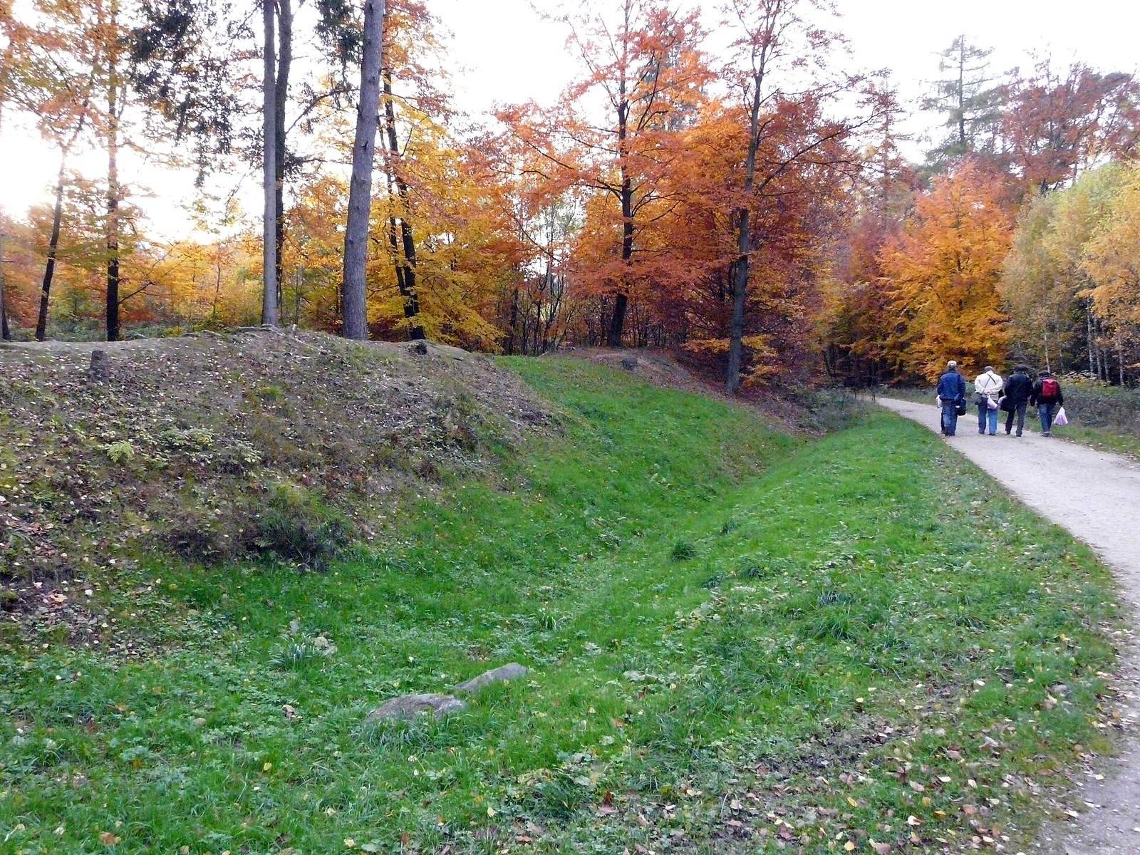
Where the frontier did not follow a river, the Upper Germanic section used an oak palisade. Its trunks were about 30 centimetres thick, set at least a metre into the ground and rising roughly three metres above it. In the Taunus and Wetterau, a developed barrier combined a palisade and earth bank with a V-shaped ditch about 6–7 metres wide and 2 metres deep. The ditch lay between the palisade and the watchtowers. In some locations a stone wall later replaced the bank and ditch; that alteration may date to the reigns of Marcus Aurelius or Commodus.
Raetian sector
In Raetia, a continuous stone wall replaced the palisade. It was about 1.2 metres thick and could reach three metres in height. Near Dambach, oak posts formed a timber foundation beneath the wall. The frontier’s course in this section is also marked by a broad band of stone rubble, sometimes visible in cultivated fields as a straight line of trees.
Watchtowers and surveyed alignment
Watchtowers
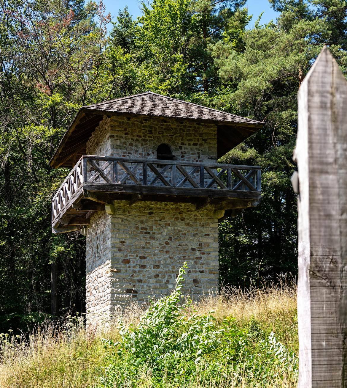
In the Odenwald, wooden watchtowers stood about 10 metres tall and were surrounded by earth banks. They were arranged so that neighbouring towers could be seen from one another, at an average distance of about 800 metres. Along both sections, small mounds of earth and rubble also mark tower locations. The bank and ditch are best preserved in woodland areas of the Westerwald and Taunus.
Straight alignment near Pfedelbach
A remarkably straight stretch runs 81.259 kilometres from a watchtower near Walldürn to Haghof, south of Welzheim. It bends briefly to accommodate terrain near Pfedelbach-Gleichen. Across more than 50 kilometres, the ditch’s centre deviates from the alignment by only 90 centimetres. This precision has been attributed to use of a groma, a Roman tool for laying out straight lines.
The tower known as WP 9/51 at Pfedelbach-Gleichen has a hexagonal plan, unlike the other towers on this stretch. Its foundations are one metre wide, with an outer base projecting half a metre. The plan and foundation suggest a building taller than an ordinary watchtower; its form and position may have made it an important point in surveying the straight route.
Forts and supporting settlements
Roads and tracks connected the frontier to a network of military bases and civilian settlements. Small auxiliary forts, spaced about 10 kilometres apart, supported the watchtower crews. Earlier forts on the Neckar and in the Taunus used timber and earth, while stone construction was also used from about AD 150. Larger forts could seek reinforcements from legionary bases and provincial capitals. Civilian settlements formed around many forts, housing soldiers’ families, merchants, craftspeople and taverns.
Forts in the Upper Germanic section
Among the forts along this section were Heddesdorf, measuring 160 by 180 metres, and Niederbieber, 165 by 198 metres, near Neuwied. Other examples include Zugmantel, 125 by 171 metres; Saalburg, 221 by 147 metres; Echzell, 248 by 208 metres; Osterburken, 186 by 115 metres; and Welzheim, 236 by 181 metres. The smaller installations included forts at Arzbach and Bad Ems, each 79 by 93 metres, and at Kleiner Feldberg, 78 by 93 metres. Small forts were also identified at Saalburg and Kapersburg.
Forts in the Raetian section
Raetian forts include Schirenhof, 157 by 130 metres; Rainau-Buch, covering 2.1 hectares; Ruffenhofen, 197 by 191 metres; Weißenburg, 170 by 179 metres; and Eining, 147 by 125 metres. A large fort at Aalen, measuring 277 by 214 metres, housed an auxiliary cavalry unit. Other small forts stood at Halheim, Dambach, Unterschwaningen, Ellingen and Böhming. A legionary fortress stood at Regensburg, the Roman settlement of Castra Regina.
Buildings within the forts
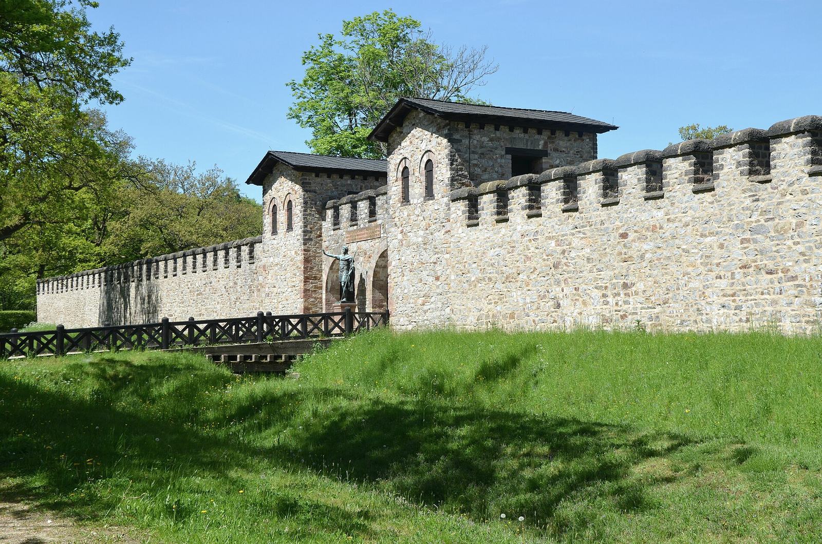
Identified fort buildings include baths at Kleiner Feldberg, Hanau-Salisberg, Erlensee-Rückingen, Neckarburken and Wuerzberg. At Saalburg, remains include the headquarters building, granaries and a gate on the road facing away from Rome. A reconstructed wall-walk runs along its rampart. Welzheim has a praetorian gate and another reconstructed rampart walkway; reconstructed gates are also identified at Weißenburg and Welzheim. A barracks for auxiliary soldiers has been rebuilt at Aalen.
Local features and modern presentation
Dalkingen
At Dalkingen, the structure identified as the Limes Gate stands alongside evidence for an early wooden tower and fence. The tower is associated with a square ditch, and postholes mark a simple fence made of individual upright posts. The dating of these features and their relationship to the palisade remain disputed.
Surviving traces and reconstructions
Other remains include watchtowers at Rheinbrohl, Bendorf, Hillscheid, Taunusstein, Butzbach, Obernburg, Miltenberg and Miltenberg-Ost. Additional forts are identified at Taunusstein, Hammersbach and Holzheimer Unterwald, with a small fort at Hanau. Across Raetia, watchtower locations include Rainau-Buch and Gunzenhausen. Burgsalach, Weiltingen and Kipfenberg are also archaeological locations along the route.
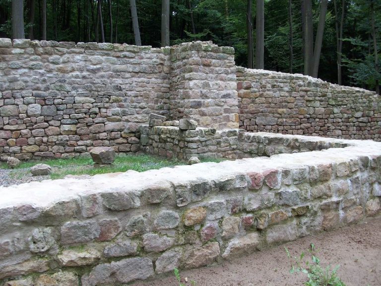
Some installations have been reconstructed to present the frontier’s form, including the Saalburg, the fort at Aalen, numerous watchtowers and a stretch near Zugmantel. At Saalburg and Welzheim, rebuilt wall-walks help convey the arrangement of the rampart; these are modern reconstructions alongside the archaeological remains.