Burg Breuberg: A Medieval Hilltop Castle in Germany


Site at a Glance
- Rating
- 4.6
- Popularity
- Medium
- Country
- Germany
- Primary era
- Early Modern
- External website
- Open
- Eras represented
- Medieval, Early Modern, Modern
- Civilizations
- Holy Roman Empire
- Site type
- Military
- Remains
- Castle
On this page21 sections
History
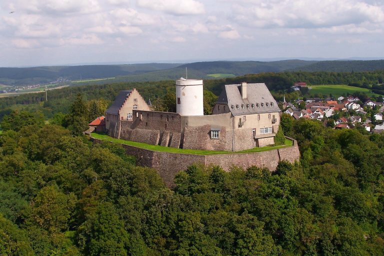
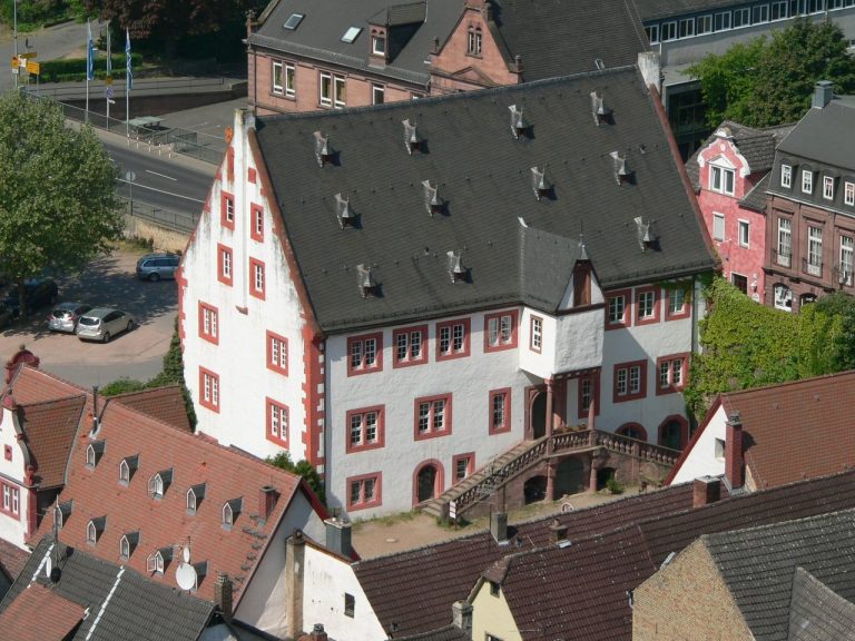
Burg Breuberg is a hilltop castle in Germany above Neustadt in the northern Odenwald, founded around 1200 by the Imperial Abbey of Fulda as a Staufian fortress in the Romanesque period. It secured Fulda’s possessions, including Höchst Abbey, and became the center of the Lordship of Breuberg.
Foundation and the Lords of Breuberg
The castle was probably established shortly after 1200 under Abbot Markward I of Fulda. The local noble family of Lützelbach held the associated bailiwick, a secular office responsible for protecting and administering ecclesiastical property. Members of the family later adopted the name Lords of Breuberg, also rendered Reiz of Breuberg. Ludwig of Lützelbach is recorded in 1115, Wiknand of Lützelbach in 1160, and Konrad Reizo of Bruberc in 1222, probably the builder’s son.
A substantial foundation found near Lützelbach Church in 2001 supports the identification of that location as the family’s ancestral castle. Breuberg itself occupied a strategic position above the Mümling valley and near the medieval Alte Frankfurter Straße, a trade route along the northern ridge that had already been used in Roman times. The settlement of Neustadt was founded below the castle in 1378.
A jointly held noble castle
The Breuberg family ended in the male line with Eberhard III of Breuberg in 1323. Half of the inheritance passed to Konrad of Trimberg, while the Counts of Wertheim and the Lords of Weinsberg each received one quarter. In 1336 the castle was divided among Wertheim, Trimberg, and the Lords of Eppstein. A partition agreement of 1337 assigned particular sections of the buildings to the different owners and set out their maintenance duties, while major facilities such as the well remained shared.
This arrangement made Breuberg a ganerben castle, a fortress jointly owned by several noble families with separate rights and responsibilities. The Counts of Wertheim gradually acquired the other shares because the castle supported their territorial policy. Count Michael II achieved sole ownership in 1497.
Wertheim residence and early modern fortress
Until the extinction of the Wertheim line in 1556, Breuberg served as a minor residence and a fortress against the territorial ambitions of the Landgraves of Hesse, the Archbishops of Mainz, and the Electoral Palatinate. After 1556 the castle was divided again. One half belonged to the Counts of Erbach, passing from 1747 to the Erbach-Schönberg line, while the other was held by the Counts of Stolberg-Königstein. From the beginning of the seventeenth century, the Stolberg-Königstein share passed to the Counts of Löwenstein-Wertheim and later to the Löwenstein-Wertheim-Rosenberg family.
The castle was adapted for firearms between 1480 and 1530, and its outer defenses were strengthened with gun towers, sloping ditch walls, and a raised cannon platform. The buildings of the outer castle were also expanded and renewed. This period transformed Breuberg from a medieval noble stronghold into a more extensive early modern fortress and residence.
Breuberg in the Thirty Years’ War
The Thirty Years’ War, the European conflict of 1618 to 1648 that divided Catholic and Protestant powers, repeatedly disrupted ownership of the jointly held fortress. After the advance of the Swedish king Gustavus Adolphus into Franconia strengthened the Protestant cause, the Protestant Counts of Erbach took full possession of Breuberg and appointed Count Gottfried of Erbach commander. His actions caused serious damage to the opposing side, and the County of Erbach later paid substantial compensation. Gottfried died in 1635 and was buried in the castle chapel.
Following the Imperial advance after the Battle of Nördlingen, Breuberg returned to the Löwenstein family under Count Ferdinand Carl of Löwenstein. Swedish forces led by Jakob von Ramsay, governor of Hanau Fortress, unsuccessfully besieged the castle in 1637. The nearby earthwork known as the Swedish Redoubt commemorates that attack. In 1639 the Erbach councillor Hinterhöfer was shot by a Löwenstein mercenary while waiting to be admitted outside the gate.
The Counts of Erbach recaptured Breuberg by surprise attack in 1644 and held it until the Peace of Westphalia ended the war. Troops continued to occupy the fortress during later conflicts, including the War of the Palatine Succession and the War of the Austrian Succession.
Administrative, industrial, and modern uses
Breuberg soon lost its importance as a residence but continued as an administrative and district office. From 1810 until about 1850, during the Napoleonic period and its incorporation into the Landgraviate of Hesse-Darmstadt, it housed the Breuberg District Office, the predecessor of the Neustadt district. These functions were then transferred to Neustadt.
At the end of the nineteenth century, a toy factory operated in the castle. A manufacturer from Mainz produced wooden African animals there for export to the United States, including New York. This industrial use ended with the First World War. After a short period of vacancy, the jointly owned castle was acquired in 1919 by the German Youth Hostel Association. When the association became part of the Hitler Youth in 1940, the property became part of the German Reich.
During the Second World War, forced laborers were housed at Breuberg. A plaque at the entrance and Cyrillic inscriptions on the keep recall their presence. In 1946 the military government transferred the castle to the newly established State of Hesse. It continues to serve as a youth hostel. Renovation took place in 1987, and the Hessian state enterprise for construction and real estate has administered the property since 2001, while the Administration of State Palaces and Gardens of Hesse is responsible for monument preservation.
The castle, its south-facing slope, and recognizable abandoned vineyard terraces form a cultural monument. The vineyards have remained uncultivated since the nineteenth century. The Breuberg Museum, established in 1963, presents the history of the castle and the region, including the transition from craft production to industry in the lower Mümling valley. The Breuberg-Bund, which promotes historical research on the Odenwald, has its seat and museum in the castle. Breuberg’s preservation has contributed to its recognition as one of the most impressive castle complexes in southern Hesse and the Odenwald.
Remains
Burg Breuberg stands on the 306-meter-high Breuberg, immediately above Neustadt. The Mümling curves around the steep-sided hill, first eastward and then northward, before reaching the Main about nine kilometers away. Most of the stone buildings are constructed from locally quarried Odenwald sandstone. The complex consists of the pentagonal inner castle, the western outer castle, and later fortification works known as the Schütt, with ditches separating the principal sections.
The inner castle
The inner castle covers about 1,900 square meters, a large area for a thirteenth-century fortress. Parts of its ditch and curtain wall survive, with small ashlar blocks characteristic of the earliest construction phase. The free-standing keep and the late Romanesque portal of the gate building are the earliest securely datable structures. Later buildings from the fifteenth to seventeenth centuries were attached to the older curtain wall.
Gate building and Romanesque portal
The western gate portal is a high-quality Romanesque work from around 1200. Its two-stage sandstone surround has slender half-columns with cushion capitals carved with palmettes. Above them runs a round-arched frieze supported partly by brackets shaped as animal or human heads. The gate building forms the principal entrance to the inner castle and preserves the architectural character of the foundation period.
Keep
The keep, the principal fortified tower, is about 25 meters high and 8.9 meters wide. Its walls are 2.5 meters thick and consist of bossed ashlar and rusticated sandstone blocks. The rusticated masonry begins above a leveling course and a smooth-ashlar base, while roughly cushion-shaped corner stones give the tower its distinctive appearance.
The Italianate roof and upper defensive platform date from 1612. Nineteenth-century reconstruction altered the dimensions and number of the battlements. A well niche on the western side, probably inserted in the early seventeenth century, resembles the niche in the round keep of Erbach Palace. The original high entrance on the eastern side was 9.5 meters above ground level and was later converted into a window.
Residential buildings and chapel
North of the inner-castle gate stands the Altbau, a fifteenth- or sixteenth-century building with a stair tower and well hall. The chapel was first mentioned in 1357, while the existing chapel, also called the New Building, dates from the sixteenth or seventeenth century. On the eastern narrow side of the courtyard, the Upper Hall Building, or Women’s House, has a late Gothic oriel and belongs to the fifteenth or sixteenth century.
The Erbach Manor House on the southern side dates from 1568. Its vaulted ground-floor hall and upper-floor living quarters reflect the castle’s use as a residence during the early modern period.
Well room and water supply
The former Old Kemenate, a medieval or early modern residential building traditionally associated with a heated room, contains the well room and an 85-meter-deep well. The wooden drawing mechanism dates from 1560 and originally used a large wheel connected to the lifting shaft by a geared axle. Much of the early modern machinery was burned as fuel after the Second World War, and the present installation was reconstructed in 1974 from photographs.
The former fittings suggest that water may have been raised by a bucket elevator, in which containers attached to a continuously circulating chain lifted water. The evidence includes the size of the water basin, the slightly twisted position of the undersized well curb, and corbel stones beneath it used for adjustment.
The earliest water supply was a cistern, first mentioned in 1357. As the castle became a residence in the fifteenth century, the cistern no longer served the enlarged household, servants, and horses adequately. A well master was commissioned to construct the shaft, but the work remained unfinished when the Counts of Wertheim became extinct in 1556. It was completed in 1560 with the construction of the octagonal well curb.
The upper part of the shaft is lined with large ashlar blocks, while its lower section cuts through the sandstone bedrock. A niche at the lower end of the masonry may have been intended for a secret passage, and a tunnel may have helped remove excavated material during construction.
By the seventeenth century the well supplied too little water. In 1754 its shaft was filled with stones, bricks, and lumps of earth, and clearing it did not restore the supply. Water was later pumped from the valley through a 2,800-meter cast-iron pipe from a station powered by the Mümling. French troops under Marshal Turenne destroyed the installation in 1675 without capturing the castle. Animals, mostly donkeys, then carried water from the Wolferhof spring. A twentieth-century pump later raised water into a container in the keep.
The western outer castle
The western outer castle developed mainly from the late fourteenth and fifteenth centuries, although its present buildings are predominantly Renaissance in date. The outer bailey expanded toward the end of the fourteenth century, when several co-owners built residences in the outer court, as recorded in 1406.
Outer gate and Hexenturm
The surviving Hexenturm formed part of a fourteenth-century outer gate and served as a prison in the sixteenth century. Both the older outer gate and the first form of the later southern gate had drawbridges, recorded in 1409. The present entrance consists of a gate building with a barrel-vaulted passage and guardroom. A heraldic cartouche dates it to 1499, although the structure was altered several times.
The original wooden drawbridge was replaced by a stone bridge in 1812. Beneath removable planks in the passage is a deep falling pit. A blocked older gate remains visible in the outer wall of the forework southwest of the present entrance. Beside the gate, above the stone bridge, a projecting grotesque head is popularly called the “Breilecker.” It sticks out its tongue rather than licking porridge, as the name suggests.
Föppelsbau and Wertheim Arsenal
The angular, elongated Föppelsbau, also called the Föppls Building or Wertheim Chancellery Building, dates from around 1560 and was built into the older ditch. Its name derives from a nineteenth-century administrator. An earlier predecessor is indicated by an inscription beside the ditch dated 1506.
The southern gable facing the bridge to the Schütt dates from the early seventeenth century. It has scrollwork, a semicircular termination with a fan rosette, and an obelisk. A stair tower with an Italianate roof occupies the courtyard angle. Around 1850 the Counts of Löwenstein had part of the building demolished, leaving the structure roofless and ruined.
The adjoining Wertheim Arsenal contains Romanesque and Gothic elements and has a Renaissance portal dated 1528. The portal bears a slightly damaged crossbowman and an attribution to Hans Stainmiller. The building also contains medieval funerary monuments, historical fire engines, and firefighting equipment.
Johann Casimir Building
The Johann Casimir Building was constructed between 1606 and 1613 beside the outer-castle gate. It retains a stone gallery and a vaulted ground-floor hall formerly used as a stable. Above it is the Knights’ Hall, whose richly stuccoed ceiling carries Johann Casimir’s ancestral arms, ornamental bands, foliage, allegorical figures, scenes from classical mythology, and a frieze of ancient deities.
The stucco belongs to the late Renaissance and Mannerist style, a period known for elaborate and sophisticated decoration. It was probably created by Eberhard Fischer of Babenhausen between 1610 and 1624. Most of the Breuberg Museum is now housed in this building.
Guardhouse
The present guardhouse is a separate wing between the inner castle’s outer defensive wall and the gatehouse. It took its current form between 1558 and 1561, although its lower storey may be slightly earlier. The building now contains the castle’s dining and refreshment facilities.
Firearms defenses and the Schütt
Between 1480 and 1530, Breuberg received a polygonal outer defensive enclosure called a zwinger, the protected space between the main fortification and an external ditch or wall. Its sloping outer ditch walls, or contrescarp, rise 10 to 14 meters above a dry ring ditch. Four massive gun towers were built between 1480 and 1507, with walls 3 to 6 meters thick. The Red Tower measures 20 meters in diameter, while the other towers measure 14.5 meters.
Gun towers
Clockwise from the entrance, the Forward Tower stands west of the gate, the Red Tower occupies the northern edge of the Fox Ditch, the Michael Tower stands east of the inner castle, and the William Tower forms part of the southeastern defensive wall. The Red Tower dates from 1507, the Michael Tower from 1504, and the William Tower was built before 1482. The Forward Tower dates from 1505 and retains a wooden gun port.
The William Tower is semicircular and attached to the southeastern wall, while the Michael Tower stands free within the outer enclosure. The William and Michael towers were linked to the inner castle by a small wooden drawbridge.
Schütt and cannon platform
A raised cannon platform was built west of the outer castle on the principal attack side. The Fox, or Mill, Ditch separates it from the older outer bailey. The Schütt contains the renovated Erbach Arsenal, timber-framed ancillary buildings, and two walled castle gardens. One garden had a pleasure house with a roof turret, visible in a Merian engraving.
The Schütt also contains a forge installed for the presentation of historic craft activity. The Erbach Arsenal has served as a registry office since 2014.
Museum collections
The Breuberg Museum presents prehistoric ceramics, Roman and medieval pottery fragments, Roman stone monuments from the surrounding region, swords, and objects connected with the Thirty Years’ War. Its small lapidarium includes a four-god stone found at Arnheiter Hof in 1543, a Roman-period human head that may represent a genius, or protective spirit, and a copy of the Raibach image.
The Schwarz Collection contains stone blades and adzes from several prehistoric periods, collected by a non-specialist from Lengfeld in the Breuberg region. The Marstall exhibition presents small-farm and craft tools together with objects from craft households, tracing the transition from handicraft to industry in the lower Mümling valley. The well room contains panels and equipment concerning the castle’s water supply.