Heidentor: A Late Roman Victory and Memorial Monument in Austria
Site at a Glance
- Popularity
- High
- Country
- Austria
- Primary era
- Classical
- Eras represented
- Classical, Modern
- Civilizations
- Austria-Hungary, Austrian Empire, Habsburg, Roman
- Site type
- Civic
- Remains
- Arch
On this page20 sections
History
Heidentor is a Roman late Roman victory and memorial monument at Petronell-Carnuntum, Austria, generally dated to the 350s, during the sole rule of Constantius II. It stood about 900 metres south of Carnuntum’s urban centre, near the southwest edge of the civilian city. Carnuntum had grown from the first century AD into a major military settlement and the capital of Upper Pannonia, a Roman province in the Danube region.
Roman foundation and purpose
The monument could not have been built before the middle of the fourth century. Its construction is usually placed in the 350s, although a later date, perhaps during the reign of Valentinian I, remains possible. Its purpose is now understood as that of a suburban memorial, probably intended to shelter an imperial statue. Earlier proposals that it was a city or road gate, a tomb, or a commemoration of the imperial meeting at Carnuntum in 308 have been set aside. A possible role as a surveying reference for the legionary camp has also been proposed, but remains uncertain.
Heidentor’s construction has been linked to the political and military pressures of the mid-fourth century. Constantius II commissioned triumphal arches on the frontiers of Gaul and Pannonia to publicize his achievements. The monument may have been built as he sought to restore imperial unity after Magnentius, a usurper who challenged his rule, had risen against him. From Sirmium, a major Roman city in Pannonia, Constantius campaigned against the Quadi, Sarmatians, and Limigantes in 357 to 359. Those campaigns are not known to have reached Carnuntum. The monument is interpreted as a public assertion of Roman authority on the contested Pannonian frontier.
The site lay between the Danube frontier route and the Amber Road, rather than directly beside either. Ditches in the area were first interpreted as traces of three temporary Roman marching camps. Later investigations identified additional structures, possibly post-Roman, and cast doubt on that identification. The surrounding ground may have served as a military staging or troop-concentration area, but this has not been established.
Abandonment, legend, and changing interpretations
Roman control of the upper and middle Danube frontier continued into the early fifth century. After the fall of the Western Roman Empire, Carnuntum’s legionary camp and civilian city were abandoned. Buildings decayed or were dismantled, and their stone was reused. Heidentor remained conspicuous even as much of the ancient city gradually became buried.
The name Heidentor means Heathens’ Gate. It arose in the Middle Ages, when Roman remains were commonly regarded as pagan. The monument was also thought to be a giant’s tomb; a thirteenth-century chronicle described a giant’s grave near Vienna. Later, local people treated Heidentor as a gate into the Roman city, although that interpretation does not fit its structure. A local treasure tale tells of a shepherd digging beside the monument for treasure marked by a blue flame. A giant warned him away and threw a large block of masonry over the hole. The story connects the fallen block east of the monument with buried treasure and reflects a local tradition of grave robbing.
Stone robbing over many centuries damaged the structure, as did blasting with black powder. The date of the blasting is uncertain: it may have occurred in the fifteenth century or during the Ottoman campaign of 1529. In the sixteenth century, Wolfgang Lazius considered whether the ruin had been a city gate or a triumphal arch. Clemens Beutler made the earliest known image of it around 1655. During visits in 1736 and 1737, Richard Pococke and Jeremiah Milles recognized it as a four-sided arch monument and noted inscribed stones reused in its walls. A later tradition credited Francis Stephen of Lorraine with ordering its protection, but stone continued to be taken from the structure.
Investigation and protection
In 1850 the industrialist Anton Widter stopped an attempt to blow up the last two standing pillars and paid for temporary stabilization. Josef Dell’s test excavation in 1891 uncovered the central statue base, which he interpreted as a tomb. Excavations in 1907 did not resolve the monument’s purpose, and about 400 cubic metres of collapse debris were removed without prior investigation. Erich Swoboda partly exposed a multi-room building southwest of Heidentor in 1955, perhaps indicating that the monument had once stood in a densely built area.
Rapid deterioration observed from 1985 led to a major investigation and restoration in 1998 to 2001, directed by Werner Jobst. The work examined the monument and its surroundings and helped establish its construction and physical history. Later European 3D recording reconstructed its appearance around 1840, around 1907, and in its present state. Since 2021, Heidentor has formed part of a UNESCO World Heritage property. It is also protected as an archaeological site under Austrian monument-protection law.
Remains
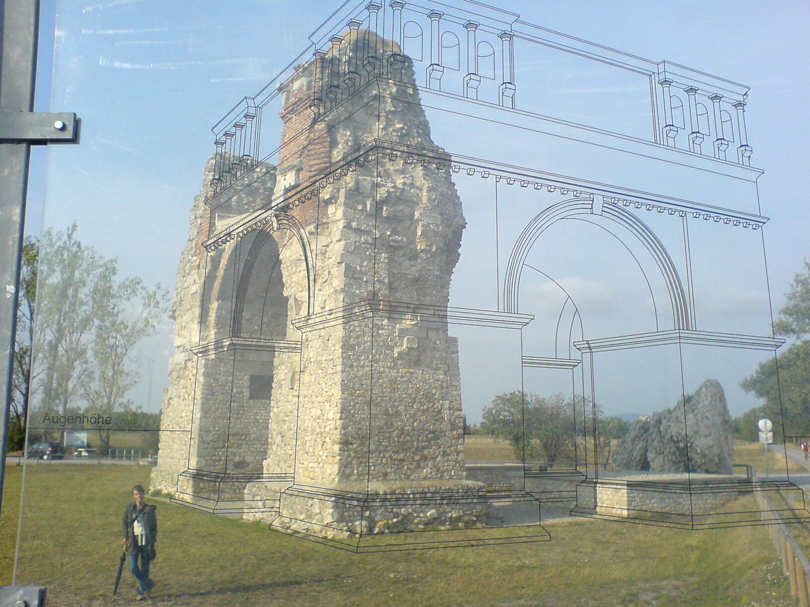
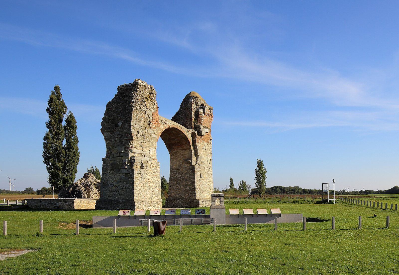
Heidentor stood on a raised terrace and was aligned with the cardinal directions, an arrangement interpreted as possibly reflecting a foundation ritual. Its square plan centred on a statue base within four massive piers joined by a vaulted crossing. The western pair of piers and their connecting arch survive, while the eastern pair collapsed. About two-thirds of the monument has been lost.
Plan and supporting structure
Foundations
The monument’s measurements give a footprint of 16.2 by 16.2 metres, while its side length is also described as about 14.5 metres. The southwest and northwest pier foundations each measure 6 by 6 metres and reach 2.30 to 2.40 metres deep. Their lowest courses consist of dry-laid rubble, with mortared rubble above; the eastern foundations are thought to have used the same construction. A level course of cut stone sits above the poured foundations, with its upper surface marking the ancient walking level. Gravel around the foundations indicates their original size and position.
Piers and vaulted crossing
Each of the four square piers was 4.35 metres wide, and the distance between them was 5.83 metres. The openings and the clear span of the vault were about 5.8 metres. The surviving western pier masonry reaches heights of 13.4 and 14.8 metres. Concrete cores were faced with cut stone or brick; the northeast core was chiefly rubble, while the southeast core was mainly brick. The stone facing narrowed toward the top. Iron clamps shaped like dovetails, or deep bonding into the surrounding masonry, secured facing blocks in the lowest courses.
The lower third of the vault was cast together with the piers. Its upper portion was formed on wooden supports and faced with stone slabs. The vault began at a simply shaped projecting cornice, traces of which remain on the piers. A return in the cornice on the northwest pier marks a projection on the inward-facing corner. The western piers and arch endured the collapse of the eastern pair. The building stone included several kinds of calcareous sandstone and shell limestone.
Upper form and decoration
Roof and upper storey
The piers rose above the vault to support a horizontal upper section. Reconstructions differ: one proposes two storeys and a pyramidal roof, while another gives the monument a single upper level and a flat roof. The limited group of recovered roof tiles favors a flat covering, although a shallow-pitched tiled roof has also been considered. A large fallen block east of the ruin belonged to an upper section carried by the northeast pier.
Surviving west façade
On the west side, part of the original stone facing survives, together with a cornice above wall blocks and a high band of masonry. Small marble brackets lined the underside of the cornice just above the arch crown. They formed part of the upper façade’s decoration, rather than supporting a projecting entablature. The strip of wall above was plastered, and some fragments retain purple paint. Two marble brackets formed the top of the upper section. Fragments of marble figures and columns point to elaborate decoration; figures about one metre high may have stood in small arched niches at the corners. An inscription panel probably occupied the centre. Traces of exterior decoration remain on the west side of the south pier, and anthracite-black as well as purple pigment survives on exterior stonework.
Central monument and reused stone
Statue base and sculpture
A circular base stood in the centre of the monument. Its foundation measured 2.20 metres across and comprised 1.20 metres of roughly worked rubble. The lower courses were laid without mortar, while the upper courses included mortar to a depth of 50 centimetres. Analysis of 44 surviving fragments supports the base’s identification as a statue support. Its reconstructed form is a stepped stone cylinder about four metres high and 2.1 metres in diameter; it was originally about 30 centimetres taller. Four of its six original blocks remain in place. The base probably carried a slightly larger-than-life statue, most likely of an emperor. Fragments from the central area may come from an over-life-size statue of Constantius II.
Altars and carved blocks
Many stones reused in the monument came from temples and shrines. Their tops and carved decoration were often cut away to make building blocks, and the pieces were set in mortar and interlocked. A Jupiter altar dedicated by Gaius Anicius Quintus, a soldier in an administrative role in the Fourteenth Legion, was built into the south face of the northwest pier. It was removed in 1999, leaving its impression in the mortar. A second nearby altar is represented by part of its moulded base. A Diana altar removed from the southwest pier in 1907, along with dedications to Diana and possibly Apollo, is also represented by surviving impressions. Other reused altars were dedicated to Silvanus, Mercury, or possibly Mithras. A relief recovered from the northwest pier probably came from a tomb. Two further reused pieces were built into the lowest courses of the northeast pier foundation: an altar top with an offering hollow and a fragment of a carved horizontal beam.
Excavated materials
Coins, pottery, and building materials
Excavations recovered more than 300 coins dating from the reign of Constantine I to those of Valentinian I or Valens, with most issued under Constantine’s sons. Finds in the surrounding collapse debris included rubble, bricks, lime mortar, red wall plaster, carved architectural fragments, reliefs, pieces of marble statues, pottery, and metal objects, including a small bronze dragon head. The pottery included coarse wares, hand-formed vessels, and fine Roman tableware known as terra sigillata. Some grey pottery bears decoration made by smoothing the surface, a technique that appeared from the late fourth century; most of the grey pottery dates to that period.
Bricks from the piers and vault carry stamps associated with the Tenth, Fourteenth, and Fifteenth Legions, as well as one from the First Aelian Archer Cohort, an auxiliary military unit also attested at Klosterneuburg. Other bricks bear stamps for Atilia Firma and Gaius Valerius Constans, private brickmakers probably active in the area. Cut edges on fragments of altar rims indicate that reused stones were prepared at the site. Both the concrete core and the facing stone and bricks incorporated material from older buildings, some of it burnt.
Inscriptions and displaced pieces
Fragments show that the monument carried a construction inscription. A tablet that fell from the west side around 1868 is now in Vienna’s Kunsthistorisches Museum. A reused Mercury altar that fell from the same side before 1868 is held in the depot of the Carnuntum Archaeological Museum. Bricks and stones also preserve traces of the monument’s reused building material and carved features.
Ground setting and conservation
Surrounding surfaces and buried remains
Remains of lime-mortar flooring extend along the north, west, and south sides of the monument. In the wider area, excavators found a floor layer about five to eight centimetres thick and a gravel road to the southwest. Gravel patches near Heidentor may have formed part of a plaza. Windblown plant material gradually covered ancient foundations and many nearby wall remains, leaving the present ground level about 1.5 metres above the ancient one.
Repairs and present condition
Stabilization over roughly 150 years added rubble-stone supports to the western piers and small brick repairs, visibly different from the Roman construction in material, form, and scale. Work in 1850 supported the damaged lower parts of the western piers. Iron props added in 1868 secure surviving cornice stones and masonry above the west arch. In 1907, larger buttresses, projecting foundation plinths, a partly rebuilt section of the statue base, and a concrete weather cover over the brick arch altered the ruin. Damaged masonry was sealed with cement mortar in 1957, and the central space was filled with stone chippings. Work in 1998 to 2001 resealed cracked concrete protection, applied sand-coated, glass-fibre-reinforced resin to the pier tops, cleaned salt deposits, lichens, and algae, and conserved the eastern pier remains while improving the arch’s balance. These measures halted deterioration, but the structure requires continued inspection and maintenance.