Castle of Silves: An Islamic Citadel and Medieval Fortress in Portugal

Site at a Glance
- Rating
- 4.4
- Popularity
- High
- Country
- Portugal
- Primary era
- Medieval
- External website
- Open
- Eras represented
- Medieval, Modern
- Civilizations
- Almohad, Almoravid, Portuguese, Taifa Kingdoms, Taifa of Silves, Umayyad, Visigothic
- Site type
- Military
- Remains
- Citadel
On this page16 sections
History
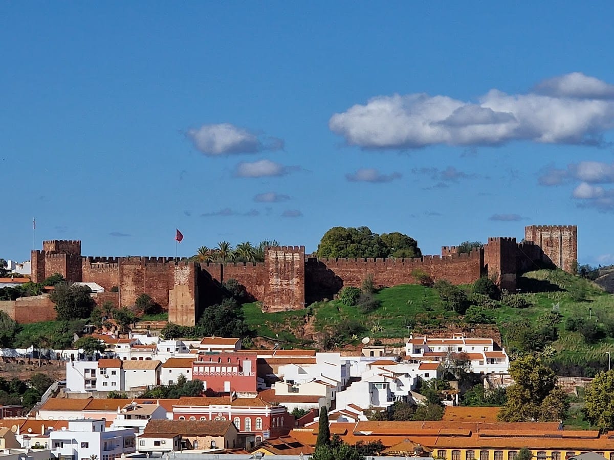
Castle of Silves is a historic fortress in Portugal, in the city of Silves. Its principal form developed through successive phases of Islamic and Christian rule, especially during the Almoravid, Almohad, and medieval Portuguese periods. Built on a hill beside the Arade River, it controlled the surrounding territory and river navigation, and Silves became one of the Algarve’s major political, commercial, and military centres.
Earlier settlement and Islamic conquest
The hill occupied by the castle may first have held a Lusitanian fortified settlement. Earlier activity at Cerro da Rocha Branca, beside the Arade, may also have included a Phoenician and Punic trading post between the fifth and second centuries BC. Rome conquered Silves around 201 BC, after which the settlement developed as a commercial and military centre. Occupation continued during the Visigothic period.
Silves came under the Umayyad Caliphate, a ruling dynasty of the Islamic world, around 716. The first Islamic builders strengthened earlier defences and created outer walls around the settlement. These fortifications were already in place by the tenth century and continued to expand into the eleventh century. During that period, Silves became the capital of an autonomous taifa, an independent Muslim kingdom formed after the fragmentation of larger caliphates in al-Andalus. Its ruler, Al-Mutamid, was also a noted Arabic poet and eleventh-century ruler of the Abbadid taifa of Seville.
The outer defences belonged to the early Islamic occupation, while the inner citadel, or alcazaba, was probably built considerably later under the Almohads. Almoravid and Almohad construction during the twelfth and thirteenth centuries gave much of the complex its later defensive character. The residential areas of the citadel probably remained in use until the Christian reconquest.
Sieges and Christian conquest
Ferdinand I of León and Castile sacked Silves in 1160, although Muslim forces soon recovered the city. The walls of the enclosed town were substantially remodelled in 1173 and again in 1189. These works preceded the campaign led by King Sancho I of Portugal, who sought to take Silves and the wider region for which it served as the principal centre.
Because the city was considered too strongly defended for a Portuguese assault alone, Sancho recruited a northern European Crusader force. The fleet, reportedly numbering 3,500 men in 36 ships, reached Silves through the Arade River in July 1189. The siege involved the capture of the outer defences, fighting around the enclosed town, siege engines, mining, and attacks on the fortified water route known as the couraça. The attackers blocked the defended well and cut the city’s water supply. After prolonged deprivation, disease, and deaths among the inhabitants, Silves surrendered on 3 September 1189. The city was then sacked despite Sancho’s opposition to the massacre of its inhabitants.
Muslim forces recovered Silves in 1191 under Abu Yusuf Yaqub al-Mansur, following an earlier unsuccessful attempt to besiege it. The campaigns caused severe destruction and contributed to the city’s decline from the prosperity it had enjoyed under its taifa rulers. Rebuilding and strengthening began in 1191 and continued until the middle of the following century, largely over earlier Almoravid structures.
Christian forces conquered Silves definitively in 1249, during the reign of Afonso III of Portugal. The Order of Santiago, commanded by Paio Peres Correia, captured the fortress and massacred its defenders. The city’s defences were rebuilt soon afterwards, but Silves was largely depopulated and ruined after the reconquest. Afonso III issued a foral, a royal charter defining a town’s privileges and obligations, in 1266 and made Silves the centre of the Algarve’s military administration. Insecurity, the rise of coastal centres, and the silting of the Arade River then reduced the city’s importance and river navigation.
Later medieval and early modern changes
The castle and its buildings were repeatedly abandoned, repaired, and rebuilt during the fourteenth and fifteenth centuries. Works were undertaken under Fernando I, João I, and Afonso V, with further interventions during the reign of Manuel I. A major fire damaged the palace within the citadel during the Christian period, while earthquakes also affected the complex.
Prince Henry became governor of Silves in 1456 and received the associated rights in 1457. A building in the southwestern part of the military square may represent his residence or the governor’s quarters. A nearby sugar mill may also have been connected with his support for sugar cultivation in the Algarve and the Atlantic islands. Around 1470, the national coat of arms was placed on the tower of the town gate. King Sebastian watched a bullfight from that tower in 1573. Earthquakes damaged the castle in 1504 and 1587.
By the early seventeenth century, sections of the town walls had collapsed, the citadel was partly filled with rubble, and some towers had fallen. During the early nineteenth century, the citadel housed the Algarve’s general gunpowder depot and a local military barracks. By the 1830s it was largely ruined and was being used agriculturally for growing barley and other cereals.
Military decline and archaeological recognition
During the Liberal Wars and the campaigns of Miguelist guerrillas commanded by Remexido, Silves’s walls retained defensive importance. Local inhabitants repaired them in 1835 and 1836, but the walls were abandoned again after the conflict and suffered further damage in the earthquake of 1856. The citadel was nearly included in a public-auction inventory in 1840, an outcome prevented after protests by the mayor, José Manuel Serpa. Municipal management followed about three years later. A prison and the prison governor’s residence were installed in the citadel around 1875.
Estácio da Veiga carried out archaeological work at the castle during the nineteenth century. Clearing the Dogs’ Cistern in 1872 brought medieval pottery fragments to light, including Islamic water jars. Until the end of that century, the tower of the town gate housed the judicial court and municipal offices.
The Castle of Silves became a Portuguese National Monument by decree on 23 June 1910. The town walls and Almedina Gate received separate National Monument protection in 2012, extending recognition to the wider fortified settlement and not only the citadel.
Restoration and archaeological research
In 1939 the citadel remained in very poor condition. Gardens, domestic animals, manure, and rubble occupied parts of the enclosure, while the prison still operated in the towers. The walls were badly cracked, had large cavities at their bases, and had been weakened when foundation stone was removed for other construction.
Major government restoration took place during the 1940s. The work consolidated some elements, demolished and rebuilt others, cleared buildings beside the walls, lowered and levelled ground near the principal entrance and military square, repaired guardhouse roofs, strengthened the keep, rebuilt a tower and part of a wall, restored battlements and gates, and cleaned the military-square cistern. The prison moved outside the city in 1947, and restoration of the citadel was formally completed the following year. Some Almohad palace ruins were destroyed during these interventions.
Further campaigns affected the town walls and citadel from 1959 to 1966, in 1969 after earthquake damage, from 1971 to 1973, in 1977 and 1979, and throughout the 1980s. A municipal museum opened in one of the towers in 1967. Later work in 1993 and from 2000 to 2003 repaired roofs and painted ceilings, improved drainage, conserved the cistern, and developed the presentation of interior spaces.
Large-scale archaeological research began in 1982. Campaigns coordinated by Rosa Varela Gomes between 1985 and 1997 examined Almohad and Almoravid occupation, domestic areas, cisterns, water-conveyance systems, and post-reconquest use. They clarified the chronology of several structures and recovered a substantial archaeological assemblage. The excavations identified Almohad baths in 1995, the first known baths of that period found in Portugal, together with evidence of Christian occupation in the thirteenth and fourteenth centuries and a lead insignia associated with an English military order.
Excavation and conservation continued in the palace area, the Dogs’ Cistern, and the surrounding historic centre during the twenty-first century. Work from 2003 to 2007, including campaigns under the Silves POLIS programme, revealed a Visigothic place of worship in the northern part of the citadel. Later investigations examined the possible residence of Prince Henry and the adjacent sugar mill. The palace area was studied further in 2016, when rare stucco fragments from decorated arcades and walls were examined and material linked to the 1189 battle was found. Excavations near the Town Gate in 2017 found seven coins beneath a sandstone-paved street, supporting a Christian-period date for the gate and pavement, possibly in the fourteenth century.
Conservation of the citadel’s round-walk began again in 2015. Restoration affected its western surroundings in 2019, and conservation of tower 4 began in 2021 as part of a programme concerning the surviving almedina walls. The castle is regarded as one of Portugal’s important Islamic fortifications and as a major monument of the Algarve because its remains preserve the city’s long urban and defensive history.
Remains
The defensive complex occupies the eastern end of a hill rising to about 56 metres beside the right bank of the Arade River. The northern and eastern slopes are particularly steep, adding natural protection to the fortification. The site is arranged around the elevated alcazaba, a fortified citadel, and the lower almedina, the enclosed urban area associated with it. A smaller wall protected suburban districts beyond the main enclosure, while the couraça formed a defended route towards the river and its water sources.
The hilltop citadel
The alcazaba has an irregular polygonal plan on a level area at the summit. Its walls follow the contours of the hill, with the northern and eastern sides at higher elevations and the southern and western sides descending partway down the slope. The fortification was built largely in military rammed earth, or taipa, a compacted mixture of clay, sand, gravel, and lime. Later Gothic pointed-arch doorways and vaulted rooms survive in some towers, reflecting fourteenth- and fifteenth-century alterations.
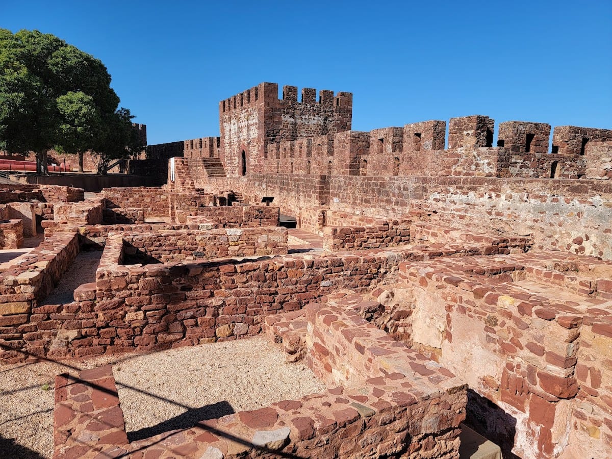
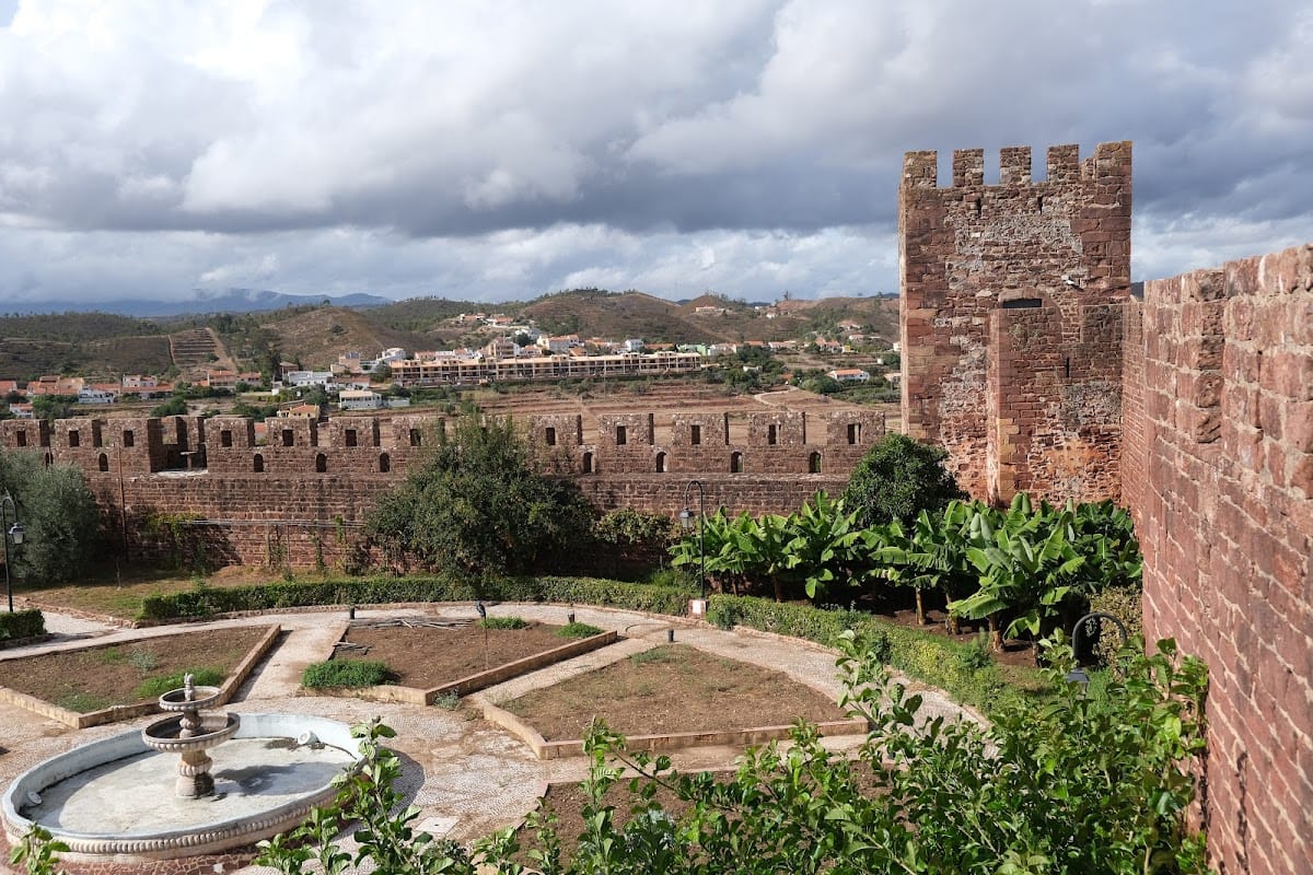
Eleven quadrangular towers reinforce the citadel. Their corners use strengthened sandstone ashlar, which consists of regularly cut blocks. Two are projecting albarran towers, positioned outside the main wall and joined to it by passages, while nine are attached directly to the curtain wall. The group includes a high keep, three larger towers, and seven smaller towers known as quadrelas. A curtain wall with battlements, loopholes, and a round-walk links the towers. This defensive passage extends for about 388 metres.
Gates and defensive circulation
The principal entrance is a double gate with an atrium protected by two towers. A second northern entrance, the Traitor’s Gate, allowed movement beyond the outer walls with greater discretion and gave the citadel some independence from the town. A bronze statue of King Sancho I stands beside the principal entrance.
The couraça linked the principal walls to the river. Four towers protected this fortified route, which allowed people in the almedina and citadel to obtain water. During the siege of 1189, attackers destroyed part of the route and blocked the associated well, helping to sever the city’s water supply.
Palace of Balconies
The citadel contains the remains of a probable two-storey palace-fortress with a rectangular plan and an area of about 320 square metres. Its rooms included halls, alcoves, courtyards, two residential groups, private bathing areas in the Almohad style, and several interior gardens. One garden had a portico and an upper gallery.
Known as the Almohad Palace or Palace of Balconies, the building had marble and tiled floors, decorated walls and arcades, and abundant stucco ornament. Its remains represent the only known Islamic palace of this type in Portugal. A reconstructed white arch stands within the palace area among the surviving ruins. The gardens have been reconstructed in an Islamic style with pepper trees, pomegranates, oleanders, citrus trees, fig trees, rosemary, blueberries, mint, roses, and sugar cane. Channels beneath the modern tea-house building supplied the original gardens. A large lime tree beside the ruins predates the reconstruction work.
Cisterns and storage spaces
Three cisterns occupied the citadel. The largest, popularly called the Moorish Woman’s Cistern, is rectangular and measures about 20 metres by 16 metres, with a height of 7 metres. Four barrel vaults rest on twelve columns, including six in the centre and six against the walls. The structure could hold approximately 1.3 million litres of rainwater and supplied much of the city until the 1990s. It was later adapted as an exhibition space.
The Dogs’ Cistern is a vertical well more than 40 metres deep. Its upper 15 metres are rectangular, while the lower part is approximately circular and connected to a reservoir. It was cleared and investigated archaeologically during the nineteenth and twentieth centuries. Several underground silos near the cisterns stored grain paid as tribute by agricultural producers. Their position below ground provided cooler conditions for preserving the grain.
Governor’s residence and sugar mill
Ruins in the southwestern part of the citadel probably belonged to an alcaidaria, the residence or administrative quarter of a fortress governor. The remains include four compartments, a pointed-arch doorway, stairs leading to a vanished upper floor, earthen foundations, a stone staircase, and a large room with traces of a vaulted ceiling. Ceramics, coins, and buckles from the fourteenth and fifteenth centuries were found there.
A nearby sugar mill dates from the fourteenth or fifteenth century and may be connected with Prince Henry’s period as governor of Silves. Two halls on the second floor of the governor’s residence retain painted wooden ceilings. One displays royal arms framed by shells and acanthus leaves, with side panels showing military trophies such as armour, flags, lances, cannon, muskets, and drums. The other presents an allegory of Mars surrounded by figurative and floral medallions.
The lower town enclosure
The lower enclosure originally surrounded approximately 9.75 to 12 hectares and almost completely enclosed the settlement. Its walls were about 2.80 metres thick. They were built in military rammed earth made from clay, gravel, sand, and lime, and faced with the red sandstone known as Silves sandstone. An external earthen barbican, an outer defensive structure protecting the base of a larger fortification, strengthened the walls.
The town enclosure originally had seventeen towers, including seven attached to the wall and ten albarran towers linked by arched passageways. Its three principal gates were the Azóia Gate in the northwest, the Sun Gate on the eastern side, and the Almedina Gate, also called the Loulé Gate. The Azóia Gate was protected by at least one octagonal tower. The massive Almedina Gate had two albarran towers and an angled entrance.
Almedina Gate and surviving walls
The Almedina Gate is the original town gate with the most substantial surviving remains. It stands near the town hall, about 60 metres west of the later Town Gate. Other surviving sections are incorporated into the urban fabric near Porta da Azóia, Gregório Nunes Mascarenhas Neto, and Nova da Boavista. A further section along Rua da Porta de Loulé forms part of the archaeological museum.
Much of the town enclosure has disappeared, including a section demolished to create access to the town-hall building. Outside the main enclosure, another wall protected eastern suburban areas known as the rabal, a term that gave rise to the Portuguese word arrabalde. Near the modern municipal library, this wall survives in one place to more than two metres high. The area also preserves evidence of residential and industrial activity, including tanning.
Town Gate
The later Town Gate is incorporated into an older sandstone albarran tower. Its angled entrance was designed to hinder attackers. The gate opened onto the city’s principal road, Rua da Sé, formerly Rua Direita. During the Islamic period, this road connected the citadel with the Great Mosque before descending in the opposite direction towards the Arade.
The Town Gate was once considered an Islamic structure, but excavations in 2017 suggested that it belongs to the Christian period, possibly the fourteenth century. A sandstone-paved street lay in front of it, and seven coins associated with the reigns of Afonso III and Denis were found beneath the pavement. The gate was dismantled and incorporated into the street pavement because of its heritage value.
Archaeological evidence and surviving collections
Finds from the citadel and town walls show occupation from the eighth century into the early modern period. They include locally and regionally made pottery, glazed and enamelled ceramics from other parts of the Iberian Peninsula, Murcia, Tunisia, and Iran, as well as coins, arrowheads, crossbow bolts, and other military objects. The excavations also revealed the Almohad baths, Christian occupation of the thirteenth and fourteenth centuries, and a lead insignia associated with an English military order.
Much of the archaeological material is preserved in the Municipal Museum of Archaeology. Among the notable objects is a twelfth- or thirteenth-century ablution basin, a vessel used for washing before or during religious rites, decorated with glazed and stamped designs. Reconstructed masonry, consolidated walls, restored battlements, museum spaces, improved drainage, and altered archaeological deposits reflect the successive conservation campaigns that shaped the complex’s present form.