Sayil: A Terminal Classic Maya City in the Puuc Region
Site at a Glance
- Rating
- 4.6
- Popularity
- Low
- Country
- Mexico
- Primary era
- Medieval
- External website
- Open
- Eras represented
- Medieval
- Civilizations
- Maya
- Site type
- City
On this page18 sections
History
Sayil was a Maya city in the Puuc region near Muna, in Yucatan, Mexico. It was established around AD 800 and occupied mainly during the Late Classic and Terminal Classic periods, when Maya political and demographic systems were changing before the Postclassic era. Built in the Puuc architectural tradition, Sayil became a substantial urban center before beginning to decline around AD 950 and being abandoned around AD 1000.
Foundation and urban growth
Sayil may have been established by small Chontal warrior groups. Its short period of occupation has also led to the proposal that the city developed from the earlier settlement of Chac II, which was occupied as early as the fifth century AD in the same valley, about 2 kilometers northwest of the Great Palace. Chac II may have remained influential while Sayil was being constructed during the Late Classic.
The city reached its greatest extent around AD 900, covering approximately 5 square kilometers according to one estimate. Other calculations place the urban area at about 3.5 square kilometers and estimate a population of 8,000 to 10,000 people. Estimates based on the number of underground water-storage chambers, or chultuns, range from 5,000 to 10,000 inhabitants. One reconstruction proposes about 10,000 residents in the city and another 5,000 to 7,000 in surrounding areas.
Sayil’s population appears to have approached the agricultural capacity of the region. Gardens and fields were cultivated among residential compounds, while neighboring valleys and satellite communities may have supplied additional produce. Sodzil, Xcavil de Yaxche, and Xkanabi may have functioned as tributary settlements connected to the city.
Government, exchange, and society
Sayil appears to have been ruled by a local royal dynasty or lineage whose wealth depended at least partly on control of productive agricultural land. Political, economic, social, and religious authority seems to have been relatively decentralized. Differences in architectural scale point to economic ranking, while cylindrical stone altars suggest elite political associations. Incense vessels indicate religious leadership, and rare imported ceramics point to social alliances between communities.
Radiocarbon and obsidian-hydration dating place Sayil relatively early within the Terminal Classic. Ceramics from the Great Palace indicate exchange with the Peten region of Guatemala. Much of the obsidian came from El Chayal in what is now southwestern Guatemala, showing that southern trade routes remained important while Sayil’s monumental buildings were being constructed.
Decline, later occupation, and rediscovery
Sayil flourished for a relatively brief period. The city began to decline around AD 950, and abandonment followed around AD 1000. Use continued for a short time after the monumental center was abandoned. C-shaped buildings near the Mirador Complex and a terrace structure at the Great Palace indicate later activity in residential areas and elsewhere across the site.
John Lloyd Stephens, an American explorer and writer, and Frederick Catherwood, an English artist and architectural draughtsman, visited Sayil in 1841. Their illustrated description, published in 1843 under the name “Zayi,” brought the ruins to wider European and North American attention. Teobert Maler visited in 1886, followed by architectural and settlement investigations by Harry E. D. Pollock and projects led by Jeremy Sabloff.
The Instituto Nacional de Antropologia e Historia carried out restoration during the first half of the twentieth century. Between 1983 and 1988, work led by Jeremy Sabloff and Gair Tourtellot included architectural and topographic mapping, household excavation, and intensive surface collection. From 1990 to 1992, Michael P. Smyth and Christopher D. Dore conducted systematic surface collection across the site at 25-meter intervals. The survey recovered nearly 30,000 ceramic fragments and 155 lithic artifacts. Sayil is managed by the Instituto Nacional de Antropologia e Historia.
Sayil forms part of the UNESCO World Heritage property known as the Pre-Hispanic Town of Uxmal, together with Uxmal, Kabah, and Labna. The property was inscribed in 1996 under criteria i, ii, and iii.
Remains
Sayil was built in a shallow valley among low, steep limestone hills in the Puuc region. The landscape has pronounced wet and dry seasons but little surface water, because porous limestone quickly absorbs rainfall. Artificial cisterns were therefore important for storing seasonal water. The city’s principal layout follows a north-south sacbe, a raised Maya road or causeway, with the Great Palace at its northern end and palace groups, temple complexes, residential areas, and a ballcourt extending southward. Most buildings beside the causeway stand to its west.
The Great Palace
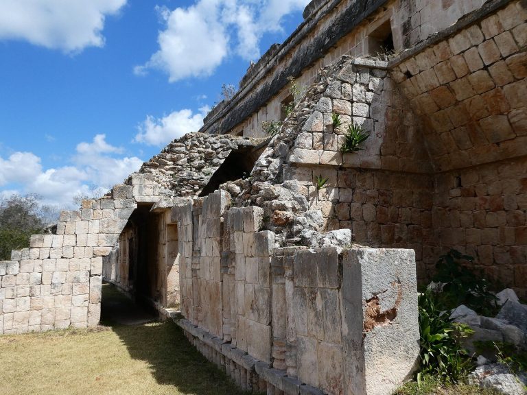
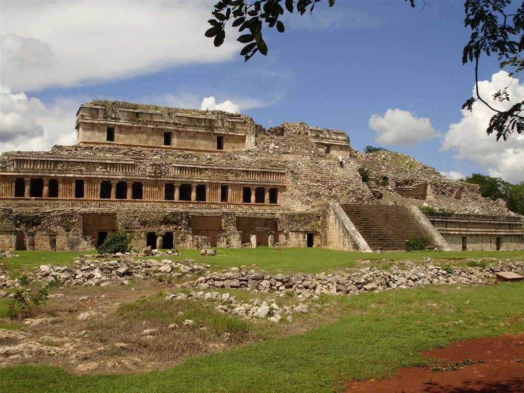
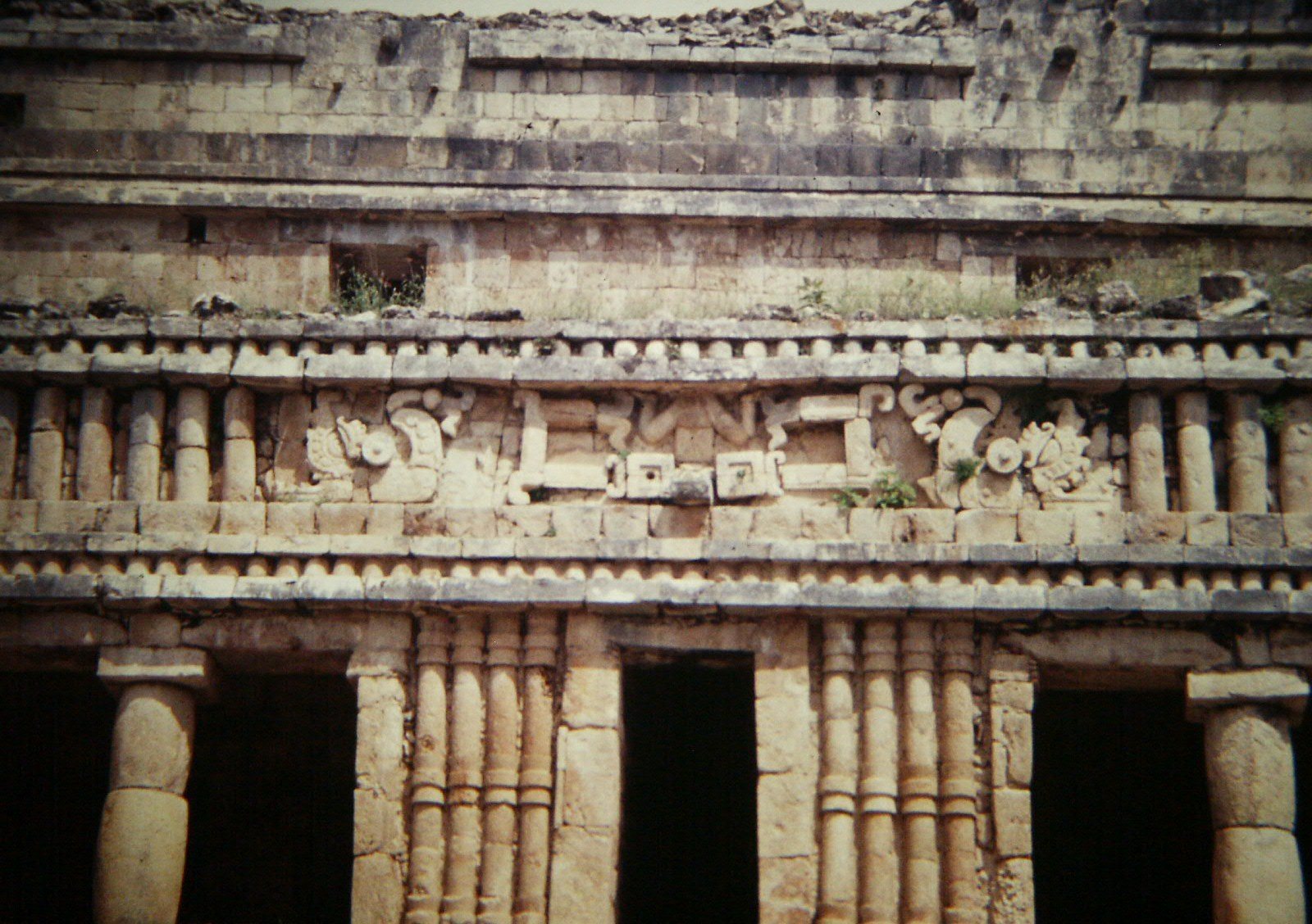
The Great Palace is Sayil’s largest and best-known building. Its facade extends for about 85 meters, and its 94 rooms occupy three levels. Built on a two-terraced platform, the palace gives the impression of three stories, with rooms arranged around the four sides of each terrace. Several Terminal Classic construction phases produced the surviving building over an uncertain period. Stone and mortar filled the platforms for stability, and a central staircase on the south side connects the upper levels.
The first and second levels incorporate earlier substructures. One Late Classic building was demolished or dismantled to make way for the palace that survives. The earliest palace component included a smaller three-room building with a central entrance supported by two columns. A western wing of four rooms was added later. Smaller rooms lay behind the front rooms, together with a narrow passage that was later blocked and part of a half-vault from an earlier dismantled structure.
Only small sections of the earliest facade survive. It used large, irregularly laid wall stones and stone lintels resting on capitals where columns stood. A broad, smooth middle cornice and a three-part upper cornice formed part of the design. The upper wall probably carried a large stone mosaic. Treatment near the staircase places this component within an early form of Puuc architecture.
Most of the ground floor appears to belong to one major building phase. A projecting western cross-wing contained six rooms. The northern wing had four and six rooms separated by a staircase, while the eastern wing had five irregularly spaced entrances leading into a sequence of eight rooms. A simpler southeast wing contained five rooms.
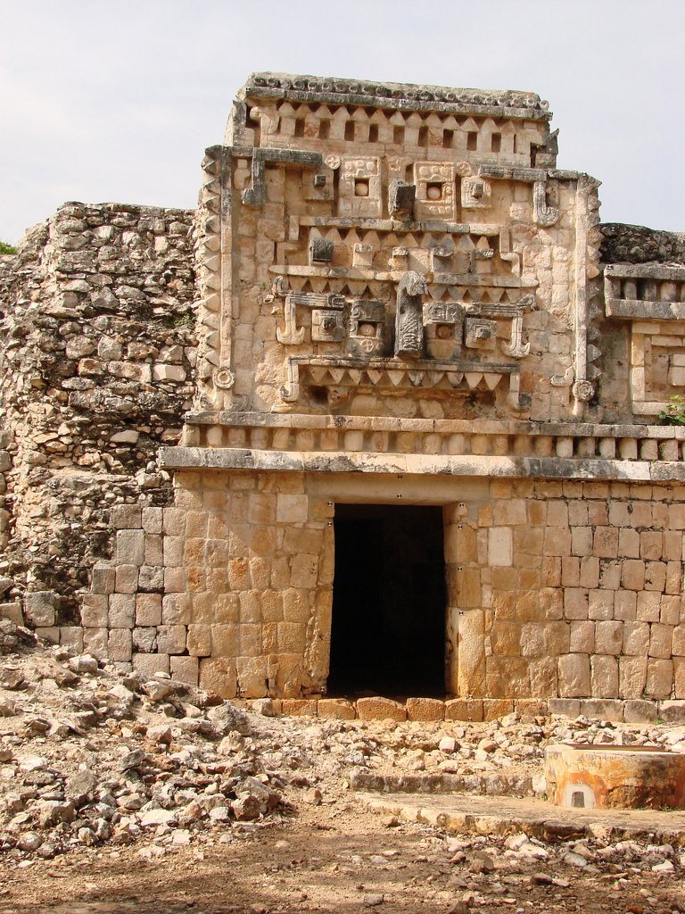
The ground-floor facade used large, generally well-cut stones and strongly developed column-like decoration. The middle cornice had three bands, including a continuous row of low columns. The upper wall carried an uninterrupted sequence of small columns with binding motifs. The upper cornice repeated the treatment of the middle cornice and ended in large stones projecting upward and forward.
The first upper story was arranged symmetrically on the south side of the central staircase, with four two-column entrances on each side. The western part remains relatively well preserved, while the eastern part has largely collapsed. Narrow doorways on both sides opened into long passages extending toward the interior. The continuation and function of these passages remain unresolved.
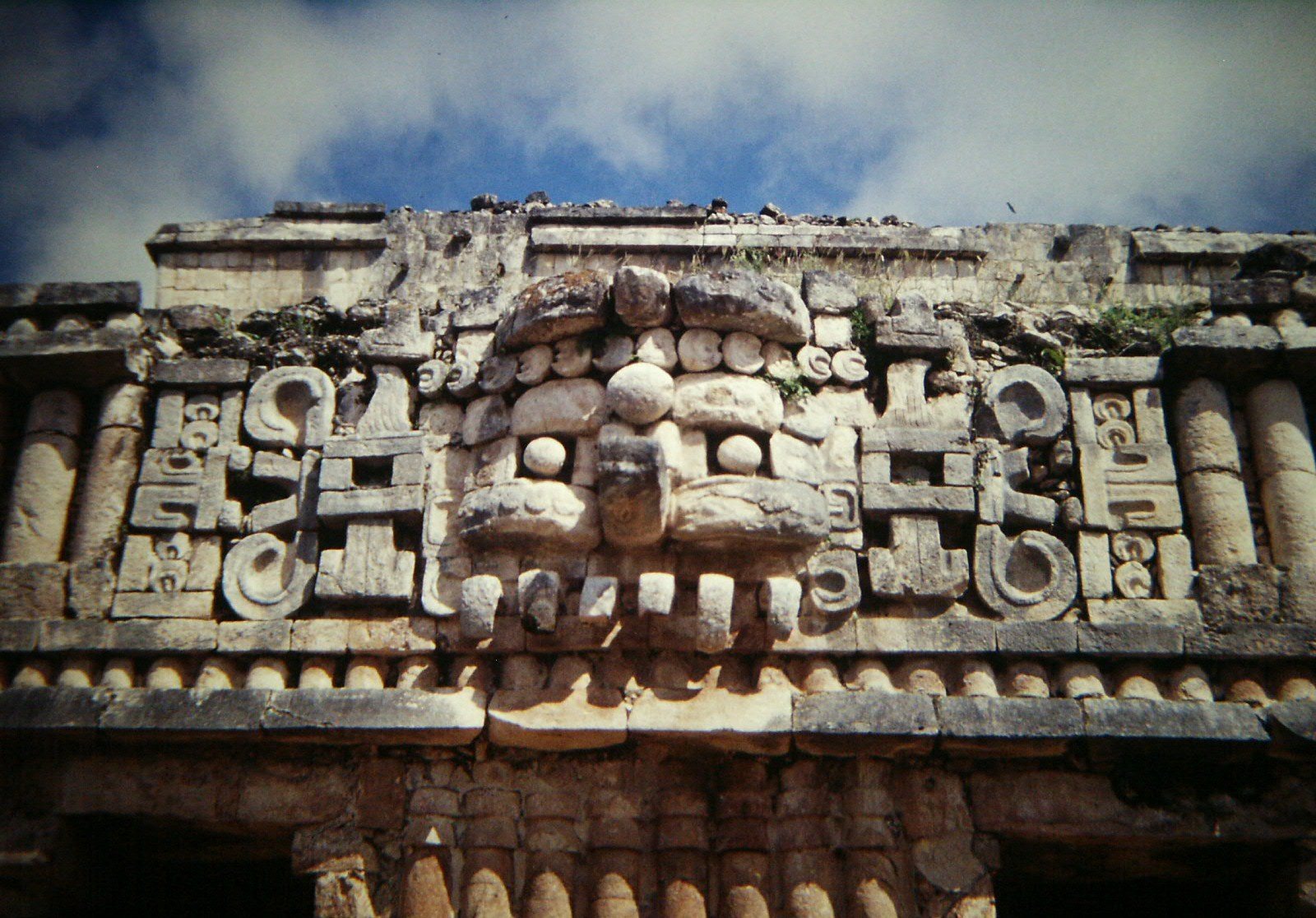
Bands and groups of small columns covered the first-story facades. A large mask of Chac, the Maya rain deity associated with rainfall and agricultural fertility, occupied the central wall area. It is uncertain whether this mask formed part of a two-mask cascade. Other decoration included repeated falling-figure motifs framed by two open-mouthed, dragon-like beings. The western facade followed a similar design and had another large Chac mask above its central entrance.
On the north side of the first story, five simple entrances stood on each side of a central entrance divided by two columns. Several rooms were probably filled with rubble and blocked in preparation for a second story. A staircase toward roof level was begun but not completed. The eastern side is poorly preserved but appears to have followed the design of the western facade.
The uppermost story consisted of one row of seven rooms, with an additional room projecting in front of the central room. The two corner rooms had extra entrances on their short sides. This level had relatively plain facades, three-part cornices, smooth wall surfaces, and wooden lintels. Projecting stone elements above the walls may have supported stone sculptures, although this reconstruction remains hypothetical. A later southwest ground-level addition has an inner-corner facade resembling the palace’s rear facade and belongs to the small-column Puuc style.
Causeways and southern groups
Mirador Complex
The principal sacbe runs about 350 meters south from the Great Palace to the Mirador Complex. El Mirador is a badly damaged, south-facing building on a low substructure. It contains two rooms and is roughly half collapsed. A nearby phallic sculpture is of uncertain date.
Southern palace group
From the Mirador Complex, a second sacbe runs about 200 meters southeast before turning south toward a major group approximately 2 kilometers from the Great Palace. This group contains several palaces and a ballcourt. The southern palace is a large four-sided Puuc building arranged around a massive core of stone and rubble. A second story was built or intended above the core, but the extent to which it was completed is uncertain. The building stands near the ballcourt and the platform bearing the site’s stelae.
Ballcourt
The ballcourt lies near the northeast corner of the southern palace group. It was used for the Mesoamerican ballgame and has not been fully excavated.
Stela platform
Near the midpoint of the route from the Mirador Complex to the southern group is a small platform where the remains of eight stelae and seven plain altars were found. A stela is an upright carved stone monument that could bear images or inscriptions connected with rulers and political events. The arrangement of the monuments resembles patterns found at major eastern Puuc sites.
Sayil’s stelae were placed on a separate platform rather than directly before major buildings or stairways. They are badly preserved, and some were later re-erected near the entrance. Stylistic analysis places Stela 6 around AD 810 and Stela 5 in the ninth century. The monuments depict individuals who were probably local rulers, and one preserves a hieroglyphic reference to AD 810.
Temples and palace groups
Temple of the Hieroglyphic Doorway
Structure 3B1, known as the Temple of the Hieroglyphic Doorway, has an interior doorway decorated with a band of hieroglyphs. Puuc-style columns recur throughout the site.
Structure 4B1
Structure 4B1 has a central doorway framed by two carved columns and capitals, together with three sculptured lintels.
Hilltop palace group
Another palace group occupies a hilltop north of the causeway system and overlooks the site core. A separate hill group contains buildings attributed to an early form of the Puuc small-column style. One surviving section has inward-sloping upper walls, smooth wall areas interrupted by groups of three small columns, and a human head projecting from a central upper-wall group. A staircase on the right once led to the platform, while additional rooms have also been lost.
Building 2C4
Building 2C4, southeast of the Great Palace, belongs to the Proto-Puuc style, an early phase of Puuc architectural development. It has multiple entrances into a room and a roughly finished upper facade that probably once carried stucco ornament.
Building 1B2
Building 1B2, southeast of the Mirador, is an early Puuc structure with one surviving room and a rudimentary upper cornice. Its form represents an early stage in the development of the architectural tradition.
Residential architecture and archaeological materials
Domestic architecture included more than 300 perishable buildings erected on masonry foundations. Some foundations have been excavated. Archaeologists have mapped approximately 3.5 square kilometers of the urban core, while systematic survey covered about 2.4 square kilometers and recorded an average density of approximately 220 structures per square kilometer.
Surface collections produced large quantities of ceramic fragments and lithic artifacts, mainly made of chert, with smaller quantities of basalt, obsidian, and limestone. Nearly all of the recovered artifacts from the 1990 to 1992 survey were ceramic fragments. The obsidian came largely from El Chayal in southwestern Guatemala, providing physical evidence of imported material within the site’s archaeological remains.