Futago Kofun: An Early Kofun-Period Burial Mound in Japan


Site at a Glance
- Rating
- 3.9
- Popularity
- Very Low
- Country
- Japan
- Primary era
- Classical
- External website
- Open
- Eras represented
- Classical
- Civilizations
- Yamato
- Site type
- Burial
- Remains
- Burial Mound
On this page10 sections
History
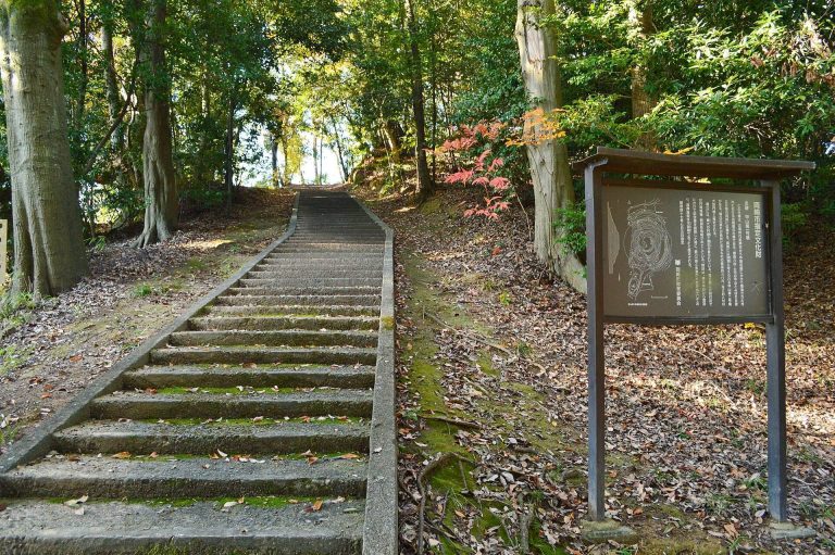
Futago Kofun is an Early Kofun-period burial mound in Japan, located in Sakurai district of Anjo, Aichi. Built during the latter half of the third to early fourth century, it is a zenpō-kōhō-fun, a tumulus formed by two connected square sections. The larger rear square contained the principal burial area, while a projecting front square extended outward. Futago Kofun is regarded as the oldest mound in the Sakurai Kofun Group and among the earliest burial mounds in the Yahagi River basin.
The Early Kofun period
The Kofun period was an era, conventionally dated from about the third to the sixth centuries, when large burial mounds were built for members of the elite. Their forms and dimensions provide evidence for changing political authority and regional organization. Futago Kofun belongs to the period’s early phase. Its construction followed the development of settlements in the Kanorigawa River basin, where communities had become involved in exchanges between different regions during the preceding Yayoi period.
The mound stands within the Sakurai Kofun Group, which consists of 21 tumuli distributed along the eastern edge of the Hekikai Plateau. Hisoyama Kofun lies approximately 200 metres to the north, while Tsukagoe Kofun is about 750 metres to the south. Himeogawa Kofun is also part of the group. The concentration of mounds reflects the importance of the Yahagi River basin during a period when the movement of people and goods helped shape regional power.
Local tradition and changing interpretation
The mound’s name, Futagoyama, appears in a document from 1710. By 1887, the Sakurai Village Gazetteer described a small shrine called Futagoyama Tenjin on the mound. The shrine was traditionally associated with a deity regarded as the twin of Yamato Takeru, a legendary prince presented in early Japanese imperial tradition as a heroic military figure. The mound’s unusual form led to the proposal that it might be an ancient imperial tomb.
Futagoyama Tenjin was incorporated into Sakurai Shrine in 1914 and was no longer situated on the mound. The broad, level summit areas and damage in parts of the earthwork may preserve traces of the former shrine. A local tradition also connects the cut-away western side of the mound’s central section with a sumo ring once associated with the shrine.
Recognition, protection, and archaeological study
Futago Kofun was designated a National Historic Site in 1927, and its protected boundaries were expanded in 1955. The designated land is owned by Anjo City and the religious corporation Sakurai Shrine. Anjo City has identified acquisition of the complete designated area as desirable for permanent preservation.
Interpretations of the mound’s shape changed as surveys improved. A 1936 survey mistakenly classified it as a front-square-and-rear-rounded tumulus and gave a length of 81 metres. Field examination of that plan in 1956 identified the rear section as square, and a municipal survey in 1959 estimated the mound’s length at more than 60 metres. A further survey in 1990 measured 74 metres.
In 2003, the Anjo City Board of Education carried out an extent-confirmation excavation in five trenches, together with a total-station survey. The work clarified the mound’s present dimensions, examined its construction, and investigated ditch-like features around parts of its perimeter. Since 2000, education authorities have also removed trees from the dense evergreen woodland that had covered the mound, creating a more open woodland while leaving the earthwork in comparatively good condition.
The surrounding archaeological evidence places the mound within a wider landscape of settlement and exchange. The Sakurabayashi site produced large quantities of pottery dating from the final Yayoi period into the Early Kofun period. The nearby Futago site yielded bronze arrowheads and Sue ware, a high-fired ceramic tradition introduced from the Korean Peninsula. These remains have contributed to the interpretation that Futago Kofun may have belonged to a person who controlled or facilitated the movement of people and goods along the Yahagi River.
Remains
Setting and overall form
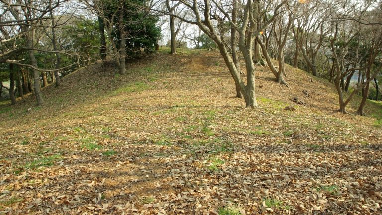
Futago Kofun occupies the projecting tip of the Hekikai Plateau. A dissected valley extends for about one kilometre to the north, while smaller valleys lie to the south and south-west. The summit is approximately 18 metres above sea level, and the mound foot is about 12 metres above sea level. This places the earthwork roughly 3.5 to 3.65 metres above the surrounding alluvial lowland.
The 2003 survey measured the mound at 68.2 metres in total length. Its rear square is 36.4 metres long and 36.2 metres wide. The front square measures 31.8 metres in length and reaches 29.6 metres in width. In its partly reduced condition, the rear square rises 6.97 metres and the front square 4.27 metres. Both sections were probably at least one metre higher before later levelling.
Earthwork and perimeter features
The western side uses the slope of a valley that continues from the Sakurabayashi archaeological site, reducing the quantity of earth required for construction. The lowest part of the mound was cut into the natural ground. The upper part was formed from earth fill, probably placed by adding soil outward from the centre.
The summit is relatively broad and level. The north-eastern corner of the rear square has been substantially cut away, as has the western side of the narrow central section joining the two squares. The latter alteration is linked by local tradition to the former shrine’s sumo ring. The present heights and summit shape therefore reflect both the original earthwork and later changes to its surface.
Possible surrounding ditches
A ditch-like feature follows the north side of the rear square, and another lies beside the south side of the front square. They may have functioned as moats, although the excavated deposits and finds do not conclusively establish that they belonged to the kofun. Their incomplete circuit may have emphasized the mound and separated it from the surrounding ground.
Ritual and surface features
The excavation reached the mound perimeter and foot, so the presence or form of stepped terraces remains unsettled. On the eastern side of the front square, a projection approximately 15 metres across may have served as a ceremonial stage. At the western foot, a space resembling an altar survives in its original form.
Soil washed from the mound contained small quantities of Haji ware, an unglazed ancient Japanese earthenware, Sue ware, and ash-glazed pottery from a later ceramic tradition. These materials provide evidence for activity associated with the earthwork and its surroundings, although they do not securely date the mound’s construction.
Burial arrangements and present surroundings
The burial facility and grave goods have not been established because the burial chamber itself has not been excavated. Comparison with Tsukagoe Kofun has raised the possibility of a wooden coffin placed directly in the ground or a coffin chamber lined with clay. The burial pit was probably made while the mound was being built rather than cut into a completed earthwork, although this remains an interpretation.
A road runs along the western foot, and the Tokaido Shinkansen railway passes immediately to the north. A municipal car park and a gateball court occupy land to the south associated with the Sakurabayashi archaeological site. Within this altered setting, Futago Kofun remains a substantial and comparatively well-preserved earthwork whose square-ended form is central to understanding the early burial mounds of the Yahagi River basin.