Vieille Cour Castle: A Medieval Fortified Residence in France


Site at a Glance
- Rating
- 4.2
- Popularity
- Very Low
- Country
- France
- Primary era
- Medieval
- Eras represented
- Medieval
- Civilizations
- Duchy of Brittany
- Site type
- Military
- Remains
- Castle
On this page16 sections
History
Vieille Cour Castle is a medieval fortified residence in Châtel-sur-Moselle, France, associated with the lords of Oudon and built during the second half of the thirteenth century. Its steep position above the Hâvre valley provided defence and allowed observation of the Angers to Nantes Roman road and river navigation. The name Vieille Cour, corresponding to the Latin Vetus Curtis, means an old enclosure or estate and, by extension, a rural domain or ruler’s residence.
Early references and foundation
Vieille Cour was first mentioned in 1140, when Geoffroy of Oudon gave all his meadows there to the monks of Oudon. The use of the word “Vieille”, meaning “old”, suggests that the place had an earlier origin. The first castle of Oudon stood on the Loire at the site of the present castle tower, but it was destroyed in the early thirteenth century. The lords of Oudon then selected Vieille Cour for a replacement stronghold because its steep location was defensible and overlooked both the road and the Hâvre.
Geoffroy de Beaumortier was lord of Oudon in 1243. His daughter Amice married Galeran III de Châteaugiron, who succeeded Geoffroy, and their son Alain III was lord of Oudon in 1271. The Châteaugiron family built Vieille Cour during the second half of the thirteenth century. The surviving enclosure and residential complex reflect the development of this seigneurial, or lordly, centre.
Military use in the fourteenth century
Vieille Cour was principally active during the fourteenth century. It was involved in the War of the Breton Succession from 1341 to 1381, a conflict over the ducal succession of Brittany that drew in rival Breton factions as well as wider English and French interests. By the late 1350s, the castle was listed among the Anglo-Breton garrisons.
Its military role ended after the strategic situation changed. The Nantes to Angers route was diverted to a towpath along the Loire, while the Hâvre became silted and unusable for navigation. Brittany also required a castle opposite Champtoceaux, on the other bank of the Loire in Anjou, which was then within the Kingdom of France.
Demolition and conversion into an estate
On 22 May 1392, Alain de Malestroit, lord of Oudon, Couffé, Le Cellier, and Vieille Cour, received permission from John IV of Montfort, Duke of Brittany, to rebuild the first castle of Oudon. The permission required Vieille Cour to be demolished, including its towers, walls, and other buildings, with its moats filled. Stone and other materials were reused in the construction of the new castle of Oudon.
By 1416, Vieille Cour had become an agricultural estate. It contained a building for hay and grain, a lean-to, a granary, gardens, warrens, and woods that produced revenue. An account from 1550 described the old castle, its enclosures, gardens, and warren as demolished and ruined.
After its military function ended, the estate passed through several noble families. It remained with the families of Châteaugiron and Malestroit until 1527, followed by the du Juch family from 1530 to 1536, the du Bellay family from 1536 to 1553, the Montmorency family from 1553 to 1632, and the Bourbon-Condé family from 1633 until the French Revolution. It was later owned by Charles Richard from 1824 to 1843, Alexandre Chauvière de La Pagerie from 1843 to 1845, and Marie Drouet and her son Constant from 1847 to 1901.
Protection and later care
Charles de Pommery acquired the Vieille Cour parcels in 1907. He was lord of La Pilardière and served as mayor of Oudon from 1908 to 1945. The ruins were protected by inscription under a ministerial order of 26 November 1942, and the site remains privately owned.
Since 2013, family succession has placed Vieille Cour in the hands of the de Perier family, which created the Association Domaine de Vieille Cour Oudon. Regular cleaning and maintenance have been carried out since then. The site also appears on Jacques Le Loyer’s 1671 to 1673 map of part of Brittany and Anjou and on the Cassini map of 1750. Le Loyer’s map depicts the vestiges and coppiced woodland of Vieille Cour, together with an image whose plan is described as accurate.
Vieille Cour is associated with a number of local legends. These include stories that the ghosts of Jean and Julien de Malestroit, condemned to death for counterfeiting in 1527, haunt a bridge below the castle, and that a white goat guards the estate. Other traditions tell of an underground passage linking Vieille Cour with the tower of Oudon, the Fountain of the Angels that never runs dry, a mysterious silver dish, the coffin of Yolande of Laval, a supernatural hunt or riders in the sky, a runaway horse, a shipwreck on the Hâvre, and the sound of Nantes Cathedral’s bell on Christmas evening. These traditions are legends rather than established historical events.
Remains
The medieval site occupies a steep slope approximately 30 metres above the Hâvre valley. It is divided into an upper court and a lower court, both enclosed by dry moats or ditches. The upper court retains most of the defensive works and the residential complex, while the lower court forms a larger outer area connected to the castle by a path.
Courts and defensive enclosure
Lower court
The lower court covers approximately 7,500 square metres and has a roughly square plan. Its ditches are partly filled, with those on the northwestern side reaching 2 to 3 metres in depth. During the twentieth and twenty-first centuries, the lower court became a chestnut grove. The area forms the outer part of the castle’s fortified arrangement, below the upper court.
Upper-court enclosure
The upper court covers approximately half a hectare. More than 200 metres of curtain wall survive outside the buildings, together with a defensive tower, a double gatehouse, and dry moats. A curtain wall is the defensive wall enclosing a fortified site. A small tower once stood at the northwestern corner of the enclosure, while the surviving defensive tower occupies the northeastern corner.
Northeastern defensive tower
The northeastern tower is an open-backed structure approximately 8 metres high, with walls 1.70 metres thick. Its internal wooden structure has disappeared, although two arrow-slit embrasures survive at the upper level. An arrow slit is a narrow opening through which defenders could use bows or other projectile weapons. The tower originally contained two wooden floors, and its outer wall inclines inward in a form known as batter, which strengthened the base.
Gatehouse and river watch
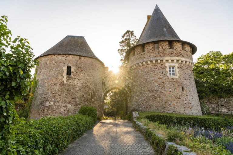
Double gatehouse
The double gatehouse contained a carriage entrance and a pedestrian entrance. It linked the lower and upper courts across a drawbridge operated by lifting arms. Their positions remain visible through surviving bearing stones and pivot sockets. The structure also retains a rear gate, an arrow slit, steps, and a guardroom.
The gatehouse appears to have developed in two stages. The inner section belongs to the thirteenth century, while the outer masonry section was added in the fourteenth century. The outer section is approximately 5.50 metres high, showing the successive enlargement of the entrance works during the castle’s period of military activity.
River-side promontory
A masonry promontory survives below the castle on the banks of the Hâvre. It probably served to monitor river navigation, complementing the castle’s elevated position and its control of movement through the valley.
Seigneurial residence
Great hall
The residential complex is centred on a great hall measuring 20 by 13 metres. Nicolas Faucherre described it as an emblematic expression of a feudal curtis, a medieval enclosed estate or lordly residence, and as a unique surviving example in the Nantes region of a seigneurial great hall beneath a roof structure. The hall served both as a reception room and as a court of justice.
Residential complex
The residence also contained three subsidiary spaces, including kitchens with a storeroom, a service corridor with a lean-to, and chambers on the southern side. An internal moat 11 metres wide separated the residential complex from the rest of the upper court, and a terrace provided its approach.
The ruined residence retains a southern gable approximately 14 metres high. Other surviving details include the position of a fireplace with a brick flue, sockets for temporary scaffolding poles known as putlog holes, two windows, two corbels, two large openings, and three doors. Together, these remains show the scale and arrangement of the lordly residence within the fortified enclosure.