Trelleborg: A Viking Ring Fortress in Denmark
Site at a Glance
- Rating
- 4.5
- Popularity
- Low
- Country
- Denmark
- Primary era
- Medieval
- External website
- Open
- Eras represented
- Medieval
- Civilizations
- Danish
- Site type
- Military
- Remains
- Fort
On this page18 sections
History
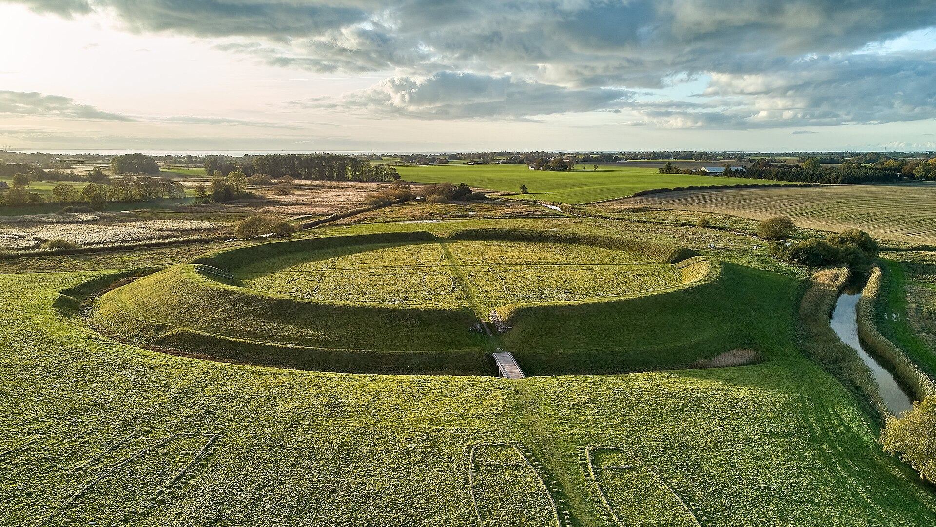
Trelleborg is a Viking ring fortress in Denmark, located west of Slagelse on Zealand and probably commissioned by King Harald Bluetooth around AD 980. Built during the late Viking Age, it may have helped control the Great Belt, the major strait between Zealand and Funen, and its maritime traffic. When constructed, the fortress stood on a peninsula extending into marshland between two rivers, with a navigable lake linking the marsh to the Great Belt and allowing Viking ships to reach the site.
Foundation under Harald Bluetooth
Dendrochronology, the dating of wood through its annual growth rings, places the felling of the construction timber in autumn AD 980. The timber was probably used to build the fortress in spring AD 981. This evidence revised an earlier date near AD 1000 and places Trelleborg within the period when Harald Bluetooth was consolidating royal power and promoting Christianity in Denmark. His reign is traditionally associated with the construction of Denmark’s ring fortresses.
The fortress appears to have operated for no more than about 10 to 15 years. Its rapid construction, limited evidence for maintenance, and the apparently unfinished eastern outer rampart point to abandonment not long after completion. The site also shows signs of violent disruption. Burned timber suggests destruction by fire, while the areas around the gates indicate that some activity continued for longer than elsewhere in the fortress.
Military role and conflict
The purpose of Trelleborg has been interpreted in several ways. It may have been a military post controlling western Zealand, a guard station against local rebellions, or a base for raids and winter training. Discoveries at other ring fortresses later strengthened the interpretation of Trelleborg as part of a system for controlling the Great Belt.
Daily activity and military conflict are both reflected in the archaeological evidence. Weapons and arrowheads embedded in the ramparts and gates, together with mass graves and skeletons bearing severe combat injuries, indicate a battle during the fortress’s short period of use. The rapid burial of fallen soldiers suggests that the conflict had a direct effect on the community stationed there.
Strontium analysis, which compares chemical signatures in human remains with regional geological signatures, indicates that many people buried in the mass graves grew up in areas corresponding to modern Norway and Poland. They are therefore thought to have been foreign mercenaries serving as guards at Trelleborg. This interpretation has been linked with Harald Bluetooth’s alliance with the Obotrite Slavs, a West Slavic people living south of the Baltic Sea, through his marriage to Tove, daughter of the Obotrite prince Mstivoj.
Harald later fled to Wolin, known in the Viking Age as Jumne, in present-day northwestern Poland. He died there from wounds after fighting those pursuing him in AD 986–987. This episode belongs to the wider political setting of Trelleborg, when the Jelling dynasty, the royal house associated with Harald and the consolidation of tenth-century Denmark, was extending and defending its authority.
Excavation and heritage
Trelleborg was excavated between 1934 and 1942 under the direction of archaeologist Poul Nørlund and the National Museum of Denmark. The site was first discovered accidentally during work on a motocross track, and aerial photography identified the outer fortifications in 1936. Nørlund also directed the reconstruction of a Viking longhouse with architect C. G. Schultz. Work began in 1941–1942, and one longhouse was reconstructed in 1948.
The reconstructed building was substantially renovated in the 1980s, although later research identified inaccuracies in its design. Since 1995, Trelleborg has operated as an open-air museum presenting the fortress and its surrounding area. Finds from the excavations are divided between the museum at the site and the National Museum of Denmark in Copenhagen.
In 2023, Trelleborg was inscribed as part of the UNESCO World Heritage property Viking-Age Ring Fortresses. The inscription recognizes the fortresses’ distinctive architecture and their evidence for the strategic and military power of the Jelling dynasty. The inscribed site covers 223.8 hectares and has a buffer zone of 3,065 hectares.
Remains
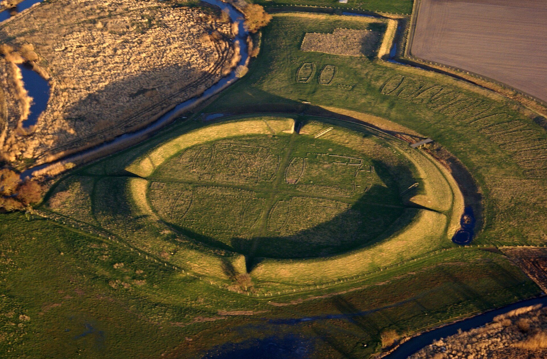
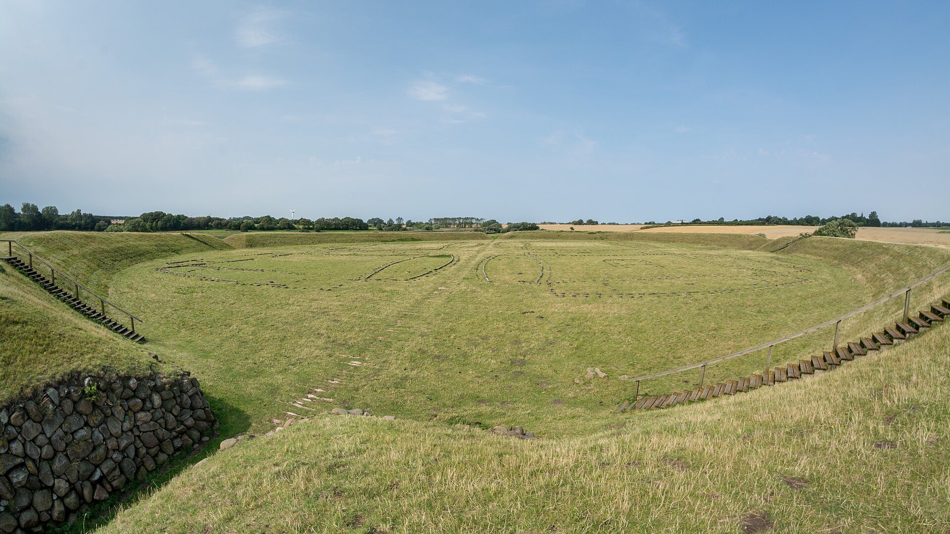
Trelleborg’s principal remains are organized around an exact circular fortress approximately 136 to 137 metres in diameter. Two wooden roads crossed at right angles at the geometric center and led to four gates, with each gate aligned with the one opposite it. Sixteen similar longhouses occupied the four quarters inside the ring, while a walled outer bailey extended from the southeastern side. The surviving archaeological evidence also includes a cemetery, defensive works, domestic objects, craft equipment, and traces of violent destruction.
Main circular fortress
Ramparts, gates, and roads
The main fortress was enclosed by a rampart about 5 metres high, approximately 17.5 metres wide at its base, and about 137 metres across. Oak formed the outer walling. Two rows of posts were supported by sloping external beams, and the space between them was packed with earth and stones. The inner wall was clad in wood, while transverse beams reinforced both faces. On the eastern side, a berm, or level strip between a fortification and a ditch, was about 5 metres wide. Beyond it lay a pointed-profile ditch roughly 17 metres wide and 4 metres deep, with a palisade of closely set pointed stakes at its base.
The two internal roads were surfaced with wood. Stone lined the inner faces of the four gates, which were among the areas where evidence for prolonged use has been found. Nineteen arrowheads were recovered deeply embedded beneath the ramparts and gates, providing physical evidence of fighting at the defensive perimeter.
Longhouses
Each of the four quarters contained four nearly identical longhouses arranged as a square. Their four groups occupied squares measuring approximately 29.42 metres on each side. The buildings had slightly ship-shaped plans, with long walls that curved outward. Each longhouse had four entrances, two in the short end walls and two in the long walls, and porches protected the entrances.
Inside, each building was divided into three rooms. The central hall measured about 18 by 8 metres and was flanked by two smaller end rooms. Their repeated arrangement and similar form created a regular internal plan within the circular defenses.
Smaller buildings
Additional buildings occupied spaces around the main groups of longhouses. Several small structures stood north of the northeastern quarter, while two small houses occupied the inner yards of the northeastern and southwestern quarters. A small square hut stood near each of the northern and western gates.
Southeastern outer bailey
Bailey and longhouses
A walled outer bailey, an enclosed subsidiary area attached to a principal fortification, extended from the southeastern side of the circular fortress. It had its own eastern rampart and is unique among the known Danish and Swedish Viking ring fortresses. Fourteen longhouses stood within it, each measuring 26.33 metres in length. Their long axes were directed radially toward the center of the main fortress.
Cemetery
The outer bailey contained a cemetery with 135 graves. Most of those buried were young men, accompanied by a smaller number of women and children. Three graves were mass burials: one contained five individuals, while two contained eleven individuals each. The simple character of most graves, along with the small number of objects placed in many of them, may indicate Christian influence. Horsemen were buried on higher ground around the fortress.
Two richly furnished graves provide a contrast with the simpler burials. One held a woman accompanied by pearls, a bronze bucket, a wooden casket, and gaming pieces. The other contained a man with a bronze bowl and an axe decorated with silver.
Objects and evidence of activity
Domestic and craft remains
Excavated objects include pottery, locks, keys, fittings, knives, whetstones, combs, weaving weights, scissors, needles, iron axes, arrowheads, and parts of shields. The assemblage also points to craft production in silver, gold, and bronze, showing that the fortress supported more than purely defensive activity.
Battle evidence
The mass graves contained bodies with deep cuts and lethal wounds caused by close-combat weapons. Together with the arrowheads beneath the ramparts and gates, these remains connect the cemetery with the battle that affected the fortress during its brief period of use.
Changing landscape and reconstructed buildings
Landscape setting
The landscape around Trelleborg has changed since the Viking Age. Post-glacial land uplift reduced the former marsh to a smaller bog, while the nearby Vårby Å and Tude Å rivers became narrow streams. These changes have altered the setting in which the fortress’s relationship with waterways and maritime movement is understood.
Reconstructed longhouse
The reconstructed longhouse was created through the early twentieth-century excavation and reconstruction program and later underwent substantial renovation. Subsequent investigations produced different interpretations of its original design, so the present building represents an informed reconstruction rather than an untouched surviving Viking structure. Reconstructed buildings and exhibition structures now form part of the open-air museum associated with the archaeological site.