Tregantle Fort: A Victorian Coastal Defence of the Rame Peninsula


Site at a Glance
- Rating
- 4.4
- Popularity
- Very Low
- Country
- United Kingdom
- Primary era
- Modern
- External website
- Open
- Eras represented
- Modern
- Civilizations
- British
- Site type
- Military
- Remains
- Fort
On this page10 sections
History
Tregantle Fort is a former coastal fortification in the United Kingdom, on Cornwall’s Rame Peninsula near Torpoint. Designed in 1858 and built between 1859 and 1865, it formed part of the Victorian defensive system created to protect Plymouth and its naval base. The fort was designed by Captain William Crossman after recommendations from the Royal Commission on the Defence of the United Kingdom, a nineteenth-century body that assessed British military and coastal defences. Captain Edmund Frederick Du Cane, later a major general, subsequently modified the design.
The Western Defences
Tregantle Fort belonged to the Western Defences alongside Polhawn Fort and Scraesdon Fort. Together, they were intended to prevent an enemy from landing on the Rame Peninsula and attacking Devonport across the Hamoaze, the tidal waterway separating Devonport from the peninsula and connecting with Plymouth Sound. Tregantle was never involved in combat, but its position formed part of a wider plan to protect the naval base from attack by land.
The original plan called for 35 32-pounder breech-loading smoothbore guns, although this armament was never fully installed. The coastal-artillery garrison was initially set at 50 men. Within a few years, however, the fort was considered obsolete, and its personnel were reduced to six gunners, six of whom were recorded there in 1882. By 1893, the weapons included five 7-inch breech-loading guns, nineteen 64-pounder muzzle-loading guns, and several 32-pounder smoothbore breech-loaders.
Replacement Battery and Changing Military Use
Between 1888 and 1894, Tregantle Down High Angle Battery was constructed a few hundred yards southeast of the fort as a replacement for the obsolete coastal position. Its four 9-inch muzzle-loading guns were designed for high-angle fire, sending shells along a steep curved trajectory toward the armoured decks of ships. The guns were removed by 1903, after which the military railway serving the battery closed and was later dismantled.
During the early twentieth century, Tregantle Fort became the headquarters of an infantry battalion and, from 1903, a rifle-training facility. It was vacated after the First World War. From 1938, the Territorial Army used it for training in passive air defence, firefighting, and rescue work. During the Second World War, the fort first supported anti-gas-defence training and then, from 1942, accommodated United States troops preparing for the invasion of Normandy.
After 1945, the fort returned to British military use and remained part of the Defence Estate. Its later roles included military training, Royal Marine training, and associations with the Royal Corps of Transport. It was also used for specialist Royal Naval electronic-warfare training involving the monitoring and decoding of ship communications. The cliffs, beach, and sea southwest of the fort have remained in military use since 1945, while the steep rifle ranges below it are used mainly by personnel based at HMS Raleigh in Torpoint. Tregantle Fort became a Scheduled Monument in 1968 and a Grade II listed building in 1987.
Remains
Fort Layout and Defences
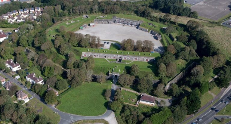
Tregantle Fort occupies a rise approximately 110 metres above Whitesand Bay on the English Channel. Its plan forms an irregular hexagon. The ground drops steeply south toward the sea, while a ditch surrounds the remaining sides. Rough limestone forms the outer walls, and the southeast entrance passes through a gatehouse with a vaulted passage.
Defensive Ditch
Three caponiers, covered defensive passages or projecting structures, extend from the western and northern sides. They allowed troops to fire into the ditch surrounding the fort. This arrangement combined the natural steep fall toward the coast with additional protection along the landward approaches.
Eastern Cavalier and Magazine
A two-storey, semicircular cavalier projects inward from the eastern wall toward the courtyard. A cavalier is a raised fortified position that can carry guns or provide additional defensive fire. At Tregantle, the structure was protected from the courtyard by another ditch and served as the principal magazine, where the fort’s ammunition was stored.
Courtyard and Accommodation
The courtyard is divided into two levels. The higher northern section served as a gun platform, while the lower southern section contained the barracks. The fort was designed with two-tier casemates, protected vaulted spaces capable of accommodating up to 2,000 men. The southern barrack area is also described as providing accommodation for a garrison of up to 1,000 soldiers.
Tregantle Down High Angle Battery
The high-angle battery stood on the northern side of the road southeast of the fort, with its gun positions approximately 100 metres above sea level. Its four 9-inch guns were arranged in two pairs on concrete mountings and could be elevated to a maximum of 70 degrees. Their range reached up to 10,000 metres. Magazines and workshops occupied the space between the gun pairs. The positions have since been filled in, and the guns and mountings removed, although the battery remains recognisable in aerial photographs.
Military Railway and Training Landscape
A landing stage called Walker Quay was built on the Lynher River to support construction of the battery. A military railway connected the quay with the battery and carried guns weighing 12 tonnes. The line was completed in 1893, closed about ten years later, and was subsequently dismantled.
The fort itself is described as complete. Its adjacent rifle ranges descend steeply toward the sea, and the cliffs, beach, and marine area southwest of the fort form part of the military training landscape associated with the site.