Streitburg Castle: A High-Medieval Hill Castle in Bavaria


Site at a Glance
- Rating
- 4.6
- Popularity
- Low
- Country
- Germany
- Primary era
- Early Modern
- External website
- Open
- Eras represented
- Medieval, Early Modern
- Civilizations
- Holy Roman Empire
- Site type
- Military
- Remains
- Castle
On this page13 sections
History
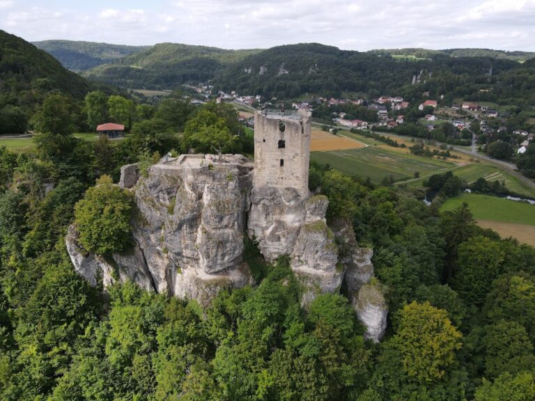
Streitburg Castle, also known as Streitberg Castle, is a high-medieval aristocratic castle in Germany above Streitberg, in the municipality of Wiesenttal, Upper Franconia, Bavaria. It was probably built before 1120 by the Lords of Streitberg, although its exact construction date is uncertain. The hill had already held a Migration Period settlement, dating to the era of major population movements and political change in Europe during the fourth and fifth centuries.
Origins and feudal allegiance
The castle began as an allodial possession, meaning hereditary property held by its owners rather than a feudal fief. Its early association with the Streitberg family is suggested by the appearance of Walter de Stritberc in the records around 1120. The Lords of Streitberg were originally ministeriales of the bishops of Bamberg. Ministeriales were service nobles in the medieval German lands who held offices, estates, or military responsibilities for ecclesiastical or secular lords.
Between 1224 and 1231, the family transferred its allegiance to the Lords of Merania, a ruling dynasty whose regional power ended when its male line became extinct in 1248. Heinrich VI of Streitberg then returned to the service of the Bishop of Bamberg. The castle’s position within this changing network of lordship reflected the political importance of Franconian noble families and ecclesiastical powers.
The Schlüsselberg period
After 1275, the powerful Lords of Schlüsselberg acquired one-quarter of Streitburg. By 1285 at the latest, they held feudal overlordship of the castle or of substantial parts of it. The Schlüsselbergs were a powerful Franconian dynasty that controlled several castles and territories before becoming extinct in 1347. Ulrich V of Schlüsselberg later directed the expansion of Neideck Castle from Streitburg, linking the two fortifications across the valley.
Bert de Streitberg was recorded as the castle’s feudal tenant in 1303. When the Schlüsselberg family died out in 1347, Streitburg was divided equally between the bishops of Bamberg and Würzburg. The Lords of Streitberg probably continued to hold part of the castle as an allodial possession, while occupying it as feudal tenants.
Margravial military and administrative use
In 1508, Streitburg passed to Margrave Friedrich of Brandenburg-Kulmbach, a member of the Brandenburg-Kulmbach branch of the Hohenzollern dynasty. The castle was then used both as a military base and as a margravial administrative seat. Hohenzollern officials who served as administrators included Konrad Schott von Schottenstein, Beringer von Kotzau, and Ernst von Kotzau.
In 1523, troops of the Swabian League passed below the castle while campaigning against Hans Thomas von Absberg, a Franconian knight identified at the time as a robber knight. A small exchange of gunfire followed because the castle administrator, Conz Schott von Schottenstein, was Absberg’s brother-in-law. The incident did not develop into a larger engagement, and Streitburg was not damaged. The castle also survived the German Peasants’ War of 1525, a widespread revolt involving rural communities and towns in the German lands.
During the Second Margrave War, a sixteenth-century conflict between Margrave Albrecht Alcibiades of Brandenburg-Kulmbach and opposing imperial, ecclesiastical, and urban forces, Streitburg was attacked on 16 June 1553. Forces from Bamberg and Würzburg, supported by troops from Nuremberg, stormed the castle under Haug von Parsberg and Claus von Egloffstein. Streitburg was conquered and destroyed.
Rebuilding and later decline
The castle was rebuilt between 1562 and 1565. Imperial troops plundered and damaged it again in 1632 during the Thirty Years’ War, the major European conflict that brought widespread military destruction and political upheaval to the German lands. After repairs, Streitburg resumed its role as the seat of a margravial office from 1657 to 1791.
The site belonged to the Bavarian state from 1803. It was sold to the municipality of Streitberg in 1812 and used as a quarry between 1811 and 1814, when the castle was almost entirely demolished. Johann Christoph Stierlein completed the first highly precise map of the castle area in 1816, recording the remains that still survived after this period of dismantling. Streitburg is now preserved as a restored ruin.
Remains
Hilltop setting and defenses
Streitburg occupies a spur position on the rocky, southwest-pointing Streitberg, 403.7 metres above sea level. The hill rises above Streitberg between the Wiesent valley and Schauertal. The main castle stood on a high massif of dolomite rock, whose sides descend almost vertically toward the Wiesent valley. Neideck Castle lies directly opposite across the valley, while several other former fortified sites were associated with the surrounding landscape.
Outer bailey and neck ditch
A strongly fortified outer bailey protected the more vulnerable northern side of the hill. The approach was separated from the main castle by a broad neck ditch, a defensive cut across the narrow land connection of a spur castle. The outer-bailey area is now built over, while the surviving defensive arrangement can still be understood through the ditch and the position of the main approach.
Gate and gun positions
Part of the gate structure from 1563 to 1565 survives near the approach. It is accompanied by a bastion, a projecting fortification designed for firearms and flanking fire, and an advanced gun tower. These features belong to the rebuilt phase after the castle’s destruction in 1553 and show the adaptation of the fortress to gunpowder warfare.
Inner castle and surviving structures
Road, terraces, and retaining walls
The castle road led to a terraced level supported by high retaining walls. This terrace formed part of the internal arrangement of the rebuilt castle and connected the approach with the principal buildings on the rocky summit. A large sixteenth-century main building with a clock tower once occupied the terrace. The surviving ground plan and retaining structures preserve the scale and organization of this central area.
Stair tower and rocky summit
Rock-cuttings mark the former position of a stair tower, which provided access to the summit of a high rocky outcrop. The cuttings are carved directly into the dolomite and remain as physical evidence of the vertical circulation system within the castle. Their position explains how the uppermost part of the rock was reached from the lower castle buildings.
Western building and cellars
A building stood below the rocky outcrop on its western side. Its surviving cellars include two barrel-vaulted chambers and another cellar cut entirely into the rock beneath them. The lower cellar contains a dungeon. The vaulted cellars are accessible during the summer and form part of the restored ruin’s principal surviving spaces.
Streitburg was built in rubble-stone masonry. Rebuilding and later repairs altered the site, while quarrying in the early nineteenth century greatly reduced its surviving fabric. The present ruin therefore preserves only a small amount of the original structure, but its hilltop position, defensive ditch, gate works, retaining walls, rock-cut features, and cellars continue to outline the castle’s development from a medieval noble seat into a fortified margravial base.
Nearby sites