Scythian Neapolis: Capital and Fortress of the Crimean Scythian Kingdom
Site at a Glance
- Popularity
- Very High
- Country
- Russia
- Primary era
- Classical
- Eras represented
- Classical
- Civilizations
- Scythian
- Site type
- City
On this page28 sections
History
Scythian Neapolis was a fortified center and capital of the Late Scythian kingdom in Crimea, located within present-day Simferopol, Russia. It developed during the second century BC and later served as a royal and administrative center. Ancient references include a second-century BC decree honoring Diophantus, a general of Mithridates VI, and Strabo’s Geography, which connects the settlement’s defenses with King Skilurus.
Early settlement and fortification
The circumstances and date of Neapolis’s foundation remain unsettled. One proposal places its founding in 199–197 BC by two people from Olbia, a Greek colony on the northern Black Sea coast, who had lost a struggle for power there. Archaeological dating instead points to an early settlement of farmstead-like complexes in the second quarter to middle of the second century BC, followed by fortification around 130 BC. Earlier finds from the late fourth to early third century BC belong to the Kizil-Koba culture of Crimea, but their relationship to Neapolis is uncertain.
Before the settlement was fortified, its dispersed complexes were probably supported mainly by farming and a mixed Greek and local culture. From about the middle of the second century BC, the settlement expanded rapidly and irregularly across at least 30 hectares. Around 130 BC, its defenses enclosed most of the inhabited area, while an existing Greek-style hall was rebuilt as the core of the Southern Palace.
A catastrophic fire soon after this transformation destroyed the known buildings and other features. Its cause is unknown. The emergence of Late Scythian culture has been explained in different ways, including as a blending of Greek, Crimean, North Caucasian, Bosporan, and La Tène-influenced traditions. La Tène refers to an Iron Age cultural tradition of central and western Europe. Another interpretation sees the culture as local, reshaped by eastern influence.
Royal center and the wars of Diophantus
In the second half of the second century BC, Neapolis was rebuilt as a stronghold, with most substantial construction concentrated around the palace. The Southern Palace became the principal residence of Skilurus and the kingdom’s political and military-administrative center. Nearby, a sanctuary associated with the nobleman Argotas was built after the fire; a monumental altar and a mausoleum associated with Skilurus followed. Together, these buildings served royal residence and worship connected with the ruling house.
Skilurus was buried in the mausoleum before the wars of Diophantus, no later than 114/113 BC. His elder son Palacus succeeded him. In campaigns against the Crimean Scythians, Diophantus defeated the combined forces of Palacus and Tasius, leader of the Roxolani, a nomadic people of the northern Black Sea steppe. The defeat brought the Scythian kingdom to its final collapse.
Urban change and the final phase
After Diophantus’s campaigns, probably around the turn of the second and first centuries BC, Neapolis entered a new phase. It likely lost its former role as a royal palace-fortress and developed into a large urban area of irregularly built fortified quarters, suburbs, and outlying settlements. Greek cultural elements became less prominent, while the material standard of life declined overall. Two fires interrupted settlement in the first half of the first century BC; their causes are unknown. A third fire in the early first century AD has been linked to military action by Aspurgus, king of the Bosporan kingdom, a Greek-led state around the present-day Kerch Strait.
From the middle of the first century AD, many building complexes in the settlement and suburbs gradually fell out of use, as did parts of the cemeteries. Between the second half of the first century and the third quarter of the second century AD, burial customs and everyday life changed, and single burials became more common. One interpretation describes the settlement as a fortified encampment of nomadic tents centered on a new royal building, the Northern Palace. The change may have involved the arrival of people associated with Sarmatian movement into the northern Black Sea region. The Sarmatians were Iranian-speaking steppe peoples. Another explanation is that the local population gradually altered its economy and customs.
In its last phase, from the late second to the first half of the third century AD, Neapolis was a large, unfortified settlement with dense, irregular development. It became an administrative center for a broad territory, and storing and processing agricultural produce grew into a principal activity. The Northern Palace may have housed a Bosporan governor responsible for an important food-producing region, at a time when Bosporan influence over the Crimean Scythians was strengthening.
Farming and stock raising supported the settlement, along with small-scale pottery and metalworking. Crops included barley, millet, and wheat, including emmer; the inhabitants also milled grain and cultivated grapes, and probably grew fruit and made wine. They kept horses, sheep and goats, cattle, pigs, and donkeys. Horses made up 38.4 percent of recorded domestic-animal bones, a proportion that may reflect both former pastoral nomads settling there and the presence of mounted retainers. Pottery, bone working, spinning, and weaving were chiefly household activities. Coins circulated from the Hellenistic period, the era of Greek influence following the classical age, through the early third century AD. Pottery and transport jars show connections with the Bosporan kingdom, Sinope, Chersonesus, Rhodes, and other Mediterranean markets.
Excavated buildings collapsed during a sudden, violent destruction in the first half of the third century AD. Pottery and the remains of people who died unexpectedly were found beneath the ruins; some bodies were left unburied or placed in refuse pits. The traditional explanation, a Gothic attack in 255–256, has been questioned in favor of an Alan attack. Proposed dates range from about 218 to 230–240, and neither the precise date nor the attackers are certain. The city declined and disappeared during the third to fourth centuries.
Identification and archaeological investigation
In 1827, antiquities collector A. I. Sultan-Krym-Girey noticed inscribed stone bases and a relief of a mounted figure being taken away for building stone. He informed I. P. Blaramberg, director of the Odessa Museum of Antiquities, who excavated the findspot on a small scale and published his investigation in 1831. Frédéric Dubois de Montpéreux excavated several tombs and a burial mound in the Eastern Necropolis in 1834. A. S. Uvarov undertook extensive excavations in 1853, initially interpreting the site as a Greek settlement founded by people from Rhodes that later became a residence and fortress of Scythian kings.
Excavations and the discovery of the decree honoring Diophantus helped establish the identification of Neapolis with Kermenchik, rather than Inkerman, another proposed location. An earlier theory placed the movement of the Scythian capital from the lower Dnieper to Crimea in the late fourth century BC and used it to explain the name Neapolis, meaning “New City.” The later archaeological dating of the fortress does not support that early foundation date. Investigations of the Western Necropolis began in 1872 and continued under several researchers. N. I. Veselovsky excavated the settlement and cemetery in 1889. In 1926, N. L. Ernst carried out rescue work where construction of a water reservoir affected the eastern part of the southern wall.
Systematic investigations by the Taurian-Scythian Expedition ran from 1945 to 1959 under P. N. Schulz, with A. N. Karasev directing the Simferopol team. Later work included examination of the defensive wall in 1975 and rescue excavations at the settlement and cemeteries from 1978 to 1987, prompted by expansion of Simferopol’s water-treatment facilities. Research from the 1980s onward refined the chronology of the buildings, fortifications, and burial areas, and revised interpretations of the city’s destruction. Medieval Ak-Mechet and modern Simferopol expanded over the area, while stone quarrying damaged remains and limited access to some parts of the site.
A historical and archaeological preserve was established by a resolution of the Council of Ministers of the Autonomous Republic of Crimea on 27 April 2011. The complex received federal heritage status in Russia in 2015 and is also listed as a heritage property of national significance in Ukraine.
Remains
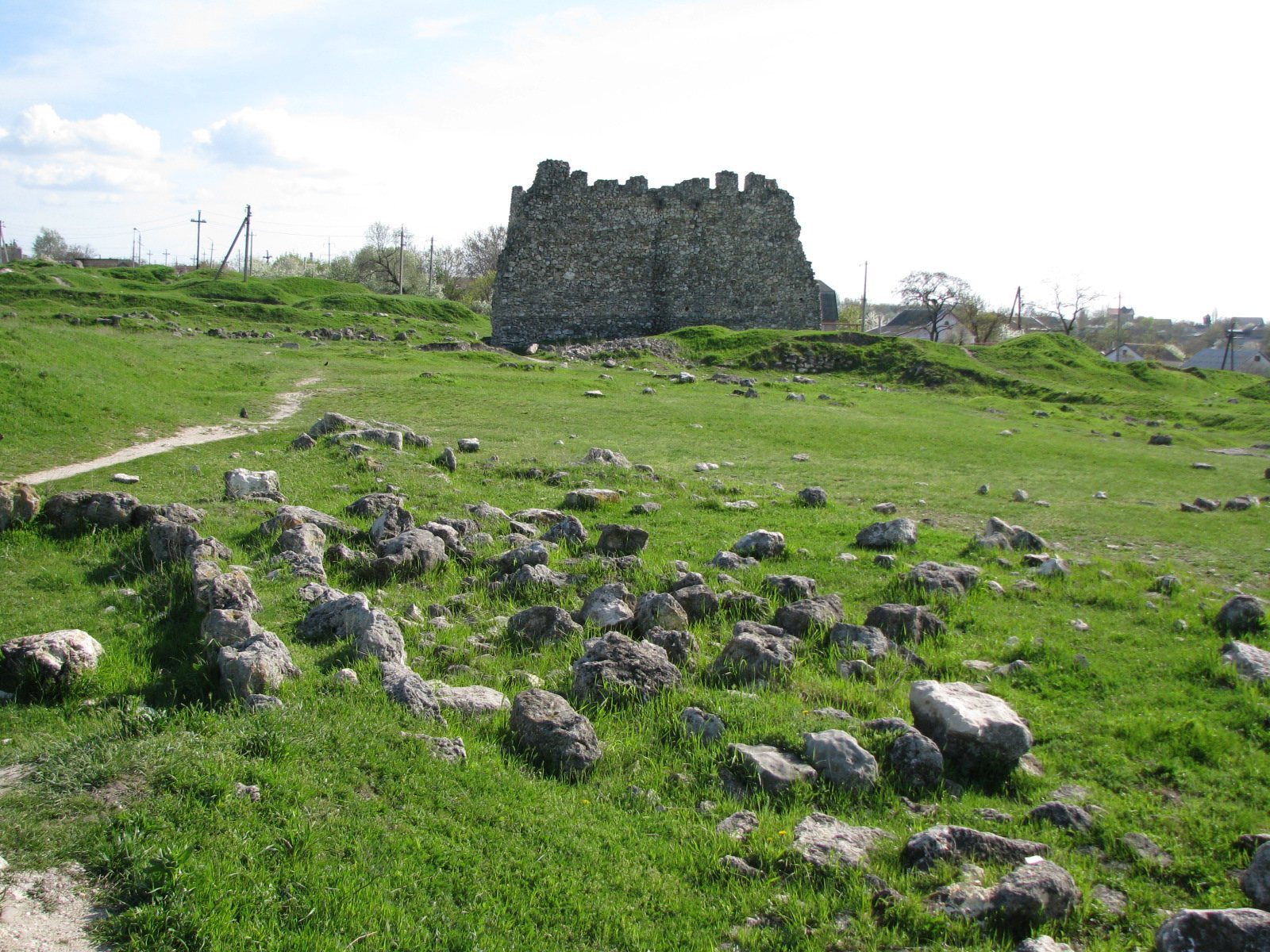
The site occupies a low plateau on the left bank of the Salgir River. Its roughly triangular plan uses a steep northeastern slope, reaching about 60 metres, and the deep Petrovsky ravine to the northwest as natural barriers. Fortifications protected the more accessible southern and southeastern approaches. The defended area covered about 18–20 hectares, within a wider settlement whose early complexes spread across at least 30 hectares. Deposits within the fortress and suburbs range from about 0.1 to 2 metres thick and date from the second century BC to the third century AD.
Defenses and entrances
Southern wall
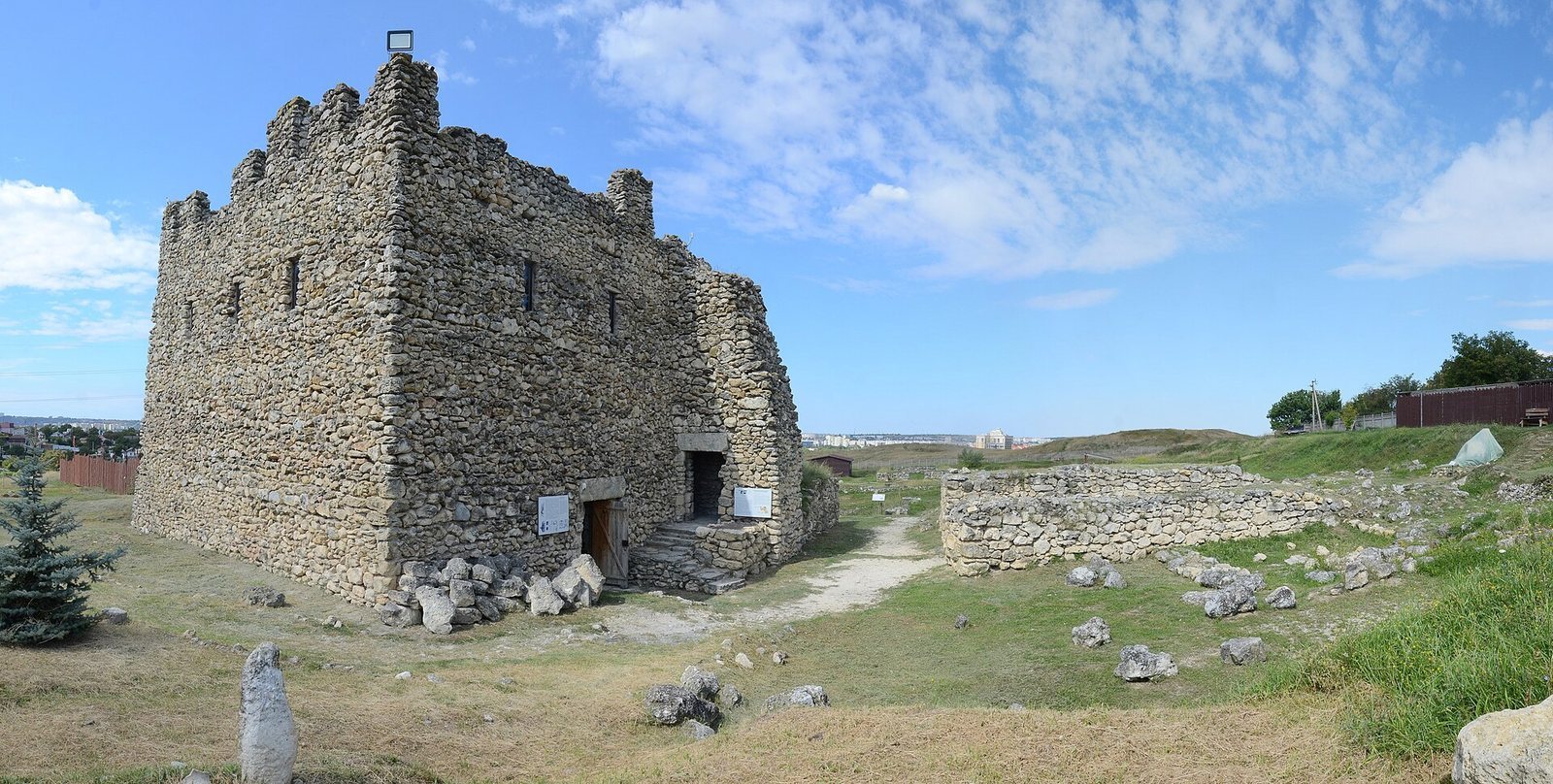
The southern defensive wall extended about 450 metres and had six towers, with the main gate between two of them. It was built and strengthened in successive stages. The earliest identified section had two sloping outer faces of large limestone blocks, a core of rubble and limestone chips, and large stones tying the faces together. This masonry probably formed a base 2.5–3 metres high and 1.3–1.4 metres wide at the top. A mudbrick or stone upper section may have raised the total height to 5–5.5 metres.
Later additions increased the wall’s thickness. West of the gate, successive inner belts measured 1.45, 2.9, 0.9, and 1.2–2 metres thick. An outer defensive work and the passage between it and the main wall brought the total thickness at this point to 12.5 metres. East of the gate, the wall belts measured 0.7–0.8, 1, 2, and 0.85 metres. The western gate pier, attached to one of the later belts, was 3.35 metres long and 1.65 metres wide; its northern side survives to 0.9 metres high. The eastern pier measured 3.75 by 1.65 metres. Beyond it, a rubble passage narrowed from 1.7 to 0.7 metres, beside an outer defense averaging about 2 metres thick.
Eastern tower and gate
The eastern tower changed shape and grew heavier through successive building stages. Its earliest rectangular chamber measured 5 by 3.5 metres, with rubble-stone walls set in clay mortar and a surrounding wall 1.3 metres thick. A later stage had walls 2.11 metres thick on the south and 1.4 metres on the east and west, built with a large-stone outer face and rubble core. A subsequent addition gave the tower a trapezoidal plan. After further reinforcement, its west, east, and south walls reached thicknesses of 4.9, 4.45, and 4.4 metres. The central gate was probably blocked across its full width with large stones when danger threatened in the third century AD.
Palaces and royal tombs
Southern Palace
The Southern Palace was centered on a large megaron, an elongated hall often built around a central hearth. It took shape when an earlier, elongated building with a hearth was rebuilt. The complex also contained an enclosed court, Greek-style houses, and walled enclosures. The hall’s proportions suggest that it may have had two storeys; thick walls and a tiled roof are also indicated. Finds from the complex include Greek ceramics, Greek beds, and imported bronze mirrors.
Northern Palace
The Northern Palace was a later royal complex and a proposed center of the settlement from the second half of the first century through the first three-quarters of the second century AD. It remained an important building in the final phase, when building quality elsewhere in the settlement was deteriorating.
Argotas mausoleum
The square mausoleum associated with Argotas stood near the royal palace. Built after the destructive fire and before the mausoleum associated with Skilurus, it had Greek architectural details, including Doric-style capitals, the carved tops of Greek columns, reliefs, sculptures, and inscriptions. Excavation took place there in 1999. An inscription has been interpreted as referring either to Argotas or to Skilurus.
Skilurus mausoleum
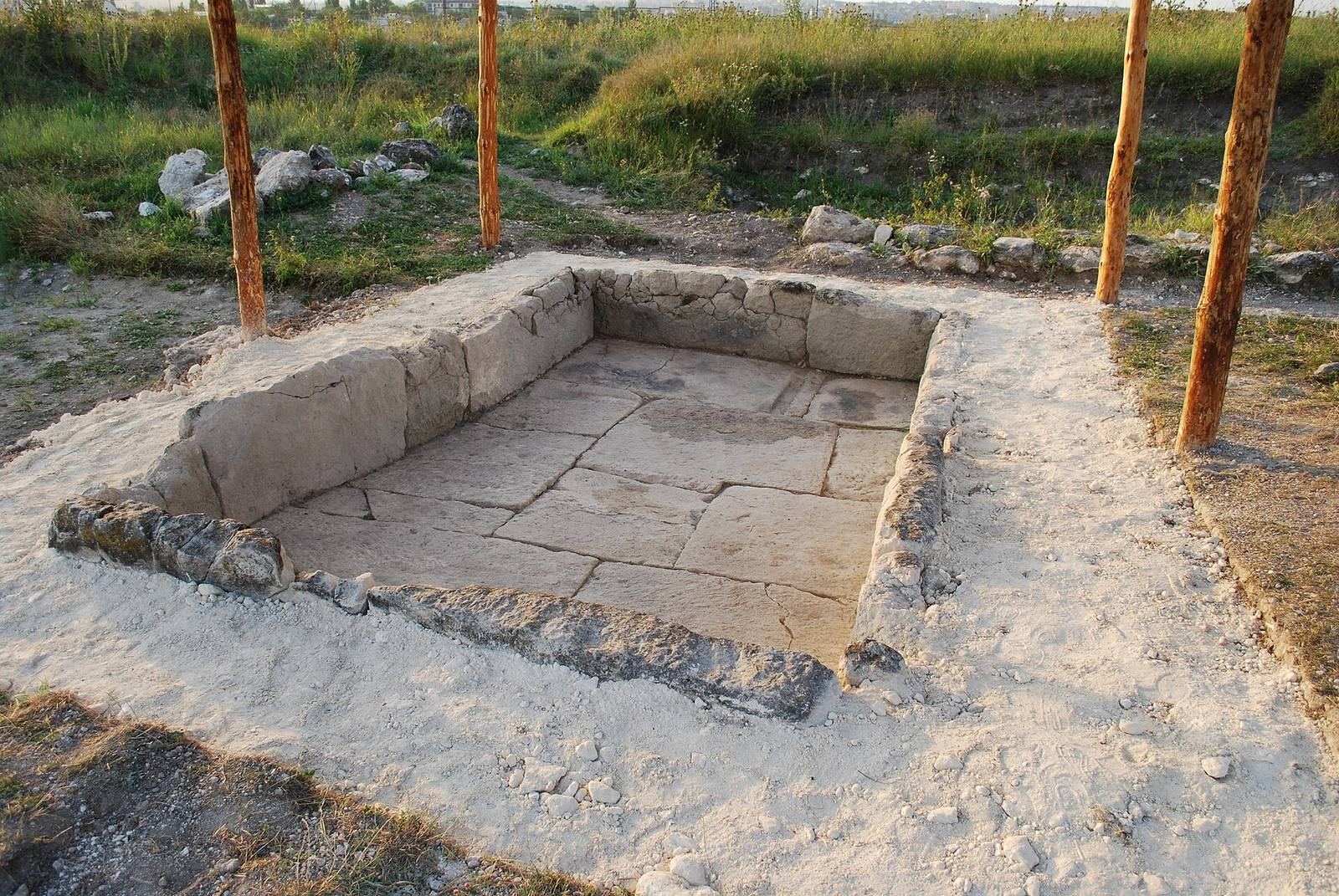
The mausoleum associated with Skilurus stood outside the fortress, west of the main gate, with its south side attached to the outer defensive wall. It measured about 8.65 by 7.5 metres externally; the burial chamber was 6.6 by 5.75 metres. Its rubble foundations rested on bedrock. Upright rough-faced slabs appeared in lower courses on the east, south, and west sides, while the interior and north side used mixed rubble masonry. Higher outer courses were carefully dressed and laid in clay. An unfired-brick upper structure began about 2.65 metres above a timber ceiling. Later sloping rubble facings covered the south and west sides. A protective pavilion now shelters the ruins and has also housed museum exhibitions.
The eastern doorway measured 1.5 by 2.2 metres and stood north of the centerline. Its closure has been dated in different interpretations to the first century BC or the first century AD. One reconstruction links it to the addition of the mausoleum to the defenses and places an 11-step stone stair beside the western wall, giving access from the roof. Another argues that the eastern entrance remained in use until fortification work sealed the chamber from both sides. In a proposed reconstruction, an oak-board barrier was braced from inside with beams, stones, and clay; a dog skeleton outside the blocked doorway may have served a protective ritual purpose.
A stone tomb in the northwestern corner was built with the mausoleum and covered by three slabs. After the central slab fell during an attempt to move it, it was set on edge against the north wall, leaving an opening 0.6 by 0.8 metres. The richly furnished male burial inside has often been identified as Skilurus’s, although the identification is uncertain. The remains and grave goods are broadly dated from the middle of the second to the middle of the first century BC, with a narrower proposed date in the second half of the second century BC.
The mausoleum held 72 burials and remains from three horse burials. The stone tomb contained a sword of La Tène type, arrows, spears, and a possible staff with a silver finial. Other finds included a cap decorated with gold plaques, gold, silver, and bronze brooches, belt fittings, a leather scabbard with a triangular silver end, an iron helmet, and gold ornaments. The helmet’s original position is uncertain. Two wooden coffins had been placed across the tomb opening, and 37 rectangular wooden boxes held other burials. Near the south wall were remains of a carved and painted wooden sarcophagus, interpreted as Skilurus’s couch, and a richly furnished female burial.
Cult buildings and ritual areas
Building A
Building A stood in the northwestern part of the site, oriented northeast to southwest. Its rectangular hall and deep porch measured 19 by 9 metres. Two building phases began in the late second or early first century BC and, probably, around the turn of the era. The later phase kept the earlier plan but strengthened the north and west walls with external supports. A circular hearth, one metre across, occupied the center of the hall. Sixteen surrounding postholes may have held supports beneath a roof opening for light and smoke. The walls were plastered inside and out, with painted interior surfaces. A refuse pit dug after the building ceased to function suggests it had been abandoned around the turn of the second and third centuries AD.
Building B
Building B lay southeast of Building A and shared its general plan, measuring 15 by 7.6 metres. It was built earlier than A and passed through two construction phases. Although it first served a cult purpose, that use probably ended after rebuilding. Thirteen complete antlers and numerous fragments from young deer, along with four small fragments from adult deer, were found in its southwestern part. The building was restored in the second to early third century AD and destroyed in the early third century.
Building Z
Building Z stood outside the fortress, about 60 metres southeast of the main gate. Its roughly north–south plan measured 11 by 5.6 metres and comprised a main hall and entrance porch. The porch’s side projections survive poorly. An infant burial lay beside the western projection. A central circular hearth pit measured 0.9 metres across. The building dates to the third or second century BC and was rebuilt after a fire in the second century BC. It had fallen out of use by the turn of the era and was later covered by ash deposits; its roof was probably made of earth.
Building E
Building E stood 47 metres southeast of the central gate and had a similar north–south orientation. It comprised a hall measuring 10.3 by 5 metres and a deep porch 5 by 1.95 metres, giving overall dimensions of 13.4 by 6.5 metres. A hearth in the hall, measuring 1.88 by 1.34 metres, retained red ochre and soot through both building phases. A clay-lined offering pit, 0.3 metres across and deep and capped with stones, contained bones from five lambs, handmade vessel fragments, and human- and animal-shaped figurines. A roof opening may have admitted light and released smoke. The building existed by the second century BC, was rebuilt in the first century AD, and ceased to exist in the third century.
Ash mounds
Ash mounds near the cult buildings may have served as places for offerings or other rituals. Mound 1, located 10 metres from Building Z, dates from the third or second century BC to around the turn of the era. After Building Z was destroyed, mound 3 covered it. Mound 3 measured about 60 metres across and up to 4 metres high. Three standing stones were found there, one still in its original position, and may relate to an altar built before the ash accumulated. Stones bordered the mound, whose surface included paving made from limestone chips; an infant burial lay beneath the paving. The deposit contained ash, soot, charcoal, and burned animal bones, as well as clay stands with ram heads, loom weights, spindle whorls, sharpening stones, red-glazed vessels, and small perfume containers.
A smaller oval ash mound southeast of Building E measured 2.5 metres long, 0.65 metres wide, and 0.5 metres high. Its purpose and date are uncertain. Finds included terracotta masks, a figure of Hermes, a head of Demeter, a gold pendant, and two bronze figures of the Dioscuri, alongside objects from the first and second centuries AD.
Other buildings, storage, and water
Buildings near the central gate
Two buildings with porticoes stood on a square surfaced with white limestone chips before the central gate. The earlier was 19.5 metres north of the gate, with walls 0.65 metres thick and probably porticoes on its east and west sides. A larger building with a similar plan replaced it 15 metres from the gate. Its walls were 0.85 metres thick, and the portico projections measured 7.8 by 2.4 metres. Some of the carefully dressed stone blocks had rough-finished faces. Proposed dates place the earlier building in the third century BC and the later one in the third to second centuries BC, possibly the second century.
Grain storage and water supply
A grain-storage area near the city wall contained 60 pits, some with a capacity of up to four tonnes. Rounded stones found near the walls and on the eastern tower floor were probably sling ammunition. The inhabitants drew water from the Salgir and from springs in the Petrovsky ravine and at the foot of the rocks. They may also have collected surface water in cisterns, basins, large jars, and reservoirs formed by dams. Traces of artificial dams lie about 300 metres southeast of the settlement. Drains and fragments of ceramic channels show water-management work within and beyond the city. Groundwater in the area lies about 0.5 to 10 metres below the surface, so wells may also have supplied water.
Cemeteries and burial remains
Western Necropolis
The Western Necropolis occupied both slopes of the water-bearing Petrovsky ravine, which drains into the Salgir. Excavated material from the cemetery dates from the second century BC to the first century AD.
Eastern Necropolis
The Eastern Necropolis lay east and southeast of the settlement, on the slopes of a ravine that once drained into the Salgir valley. Estates and working buildings occupied the nearby floodplain terrace from the second century BC to the third century AD. The cemetery’s early center was near a burial mound excavated in 1949. P. N. Schulz proposed that a reservoir and dam were built there in the second century BC, with a road crossing the dam, before the mound was raised.
Burials included earth-built catacombs, chamber graves reached through entrance passages and reused for multiple interments. More than 100 graves, including 50 catacombs, were investigated in 1956–1958. Around 30 of those catacombs contained burials dating from the second to first centuries BC through the first century AD. Rescue work from 1978 to 1988 identified additional cemetery areas and excavated 17 more catacombs.
Bitak Necropolis
The Bitak Necropolis lay northeast of the city, on the gently sloping right side of the Salgir valley. Discovered in 1979, it was investigated during rescue excavations in 1989–1991 across 5,000 square metres. The work identified 178 burial structures: 16 catacombs, 154 graves with side recesses cut from a shaft, three simple earth graves, two graves with ledges, and three horse burials. Some early graves held three to five people; catacombs could hold about 30 people in three or four levels. The cemetery dates from the late second century BC to the first half of the third century AD.
Burial mound and painted tombs
A burial mound excavated in 1949 occupied the southeastern slope of the fortress, beneath the road to the Alushta highway. It may have begun as two mounds that later joined and was enclosed by a stone retaining wall. Its earliest burial probably dates to the fourth century BC. Two tombs were subsequently built there: tomb 1, dated to the second–first centuries BC, and tomb 2, dated from the second–first centuries BC through the first century AD. Both received additional burials. Other interments included a grave with two burials from the second–first centuries BC, two graves under stone covers from the first–second centuries AD, and at least 12 inserted burials from the second–third centuries AD.
Painted and carved funerary scenes survive in the necropolis. In tomb 1, dated to the second or third century AD, a figure probably representing a goddess appears with outstretched arms and a horned headdress. A rearing winged horse is painted to her left; the scene to the right has been lost and may have shown another horse. A niche in tomb 9 depicts a building with a double-pitched roof and a ridge ornament, probably protective, made up of a spear and outward-facing horse heads. Similarities with later folk art and building decoration have been suggested, but direct continuity is uncertain.
Other finds from the settlement include grain graters, millstones, hand mills, a grape press, carbonized vine wood, apple remains, pottery-production waste, metalworking slag, casting ladles, bone tools, and equipment for spinning and weaving. Imported objects include transport jars, tableware, ornaments, beads, Roman objects, and Egyptian glazed ceramics. More than 30 sheep ankle bones from one palace hall have been interpreted as evidence of dice games. Later finds include glassware, Roman enamelled brooches, mirrors, curling irons, horse equipment, swords, and iron arrowheads of Sarmatian type. Inscriptions scratched on objects from the second half of the first to the third quarter of the second century AD have been interpreted as ceremonial signatures, ritual marks, or work by Sarmatian conquerors.