s-Hertogenbosch Citadel: A Dutch Republic Fortress in the Netherlands


Site at a Glance
- Rating
- 4.4
- Popularity
- Low
- Country
- Netherlands
- Primary era
- Early Modern
- External website
- Open
- Eras represented
- Medieval, Early Modern, Modern
- Civilizations
- Duchy of Brabant, Dutch, Holy Roman Empire
- Site type
- Military
- Remains
- Citadel
On this page12 sections
History
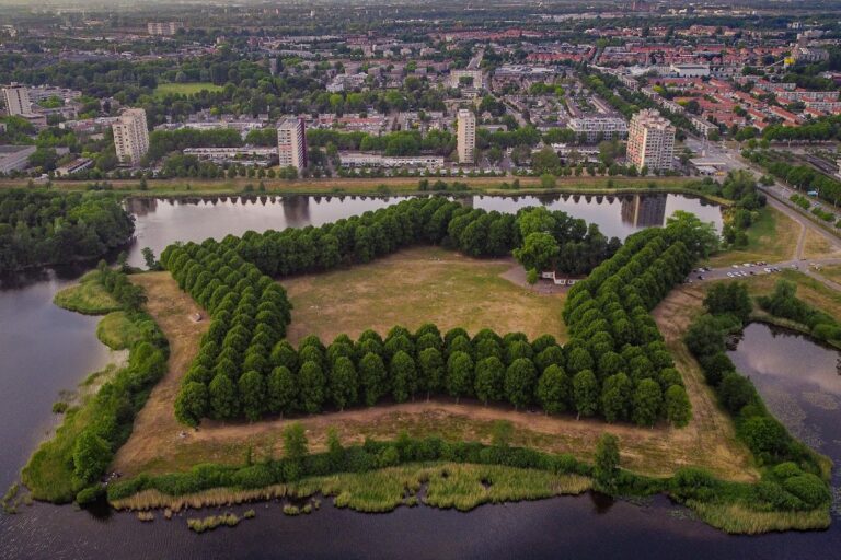
s-Hertogenbosch Citadel is a Dutch Republic fortress in ‘s-Hertogenbosch, Netherlands, built in 1637 as a regular bastioned fortification. It was constructed after the Republic conquered the city in 1629 and served both to guard against a possible Spanish attack and to monitor the city’s predominantly Catholic inhabitants.
Medieval city edge and early fortifications
During the fourteenth and fifteenth centuries, the southern part of the later citadel site lay inside the city. Houses stood there beside the Orthen Gate, which was built between 1315 and 1350. Bastion Orthenpoort was later planned to strengthen this sector. An initial attempt to construct it began in 1541 with assistance from the Italian architect and engineer Alessandro Pasqualini, but the bastion was not completed until 1617–1618, when the Dutch Republic’s military threat had become more immediate.
Construction under the Dutch Republic
Following the conquest of ’s-Hertogenbosch in 1629, the Orthen Gate was demolished in 1635. Work on the citadel began in 1637 and was probably finished by 1642, although the construction period is also given as 1637–1645. The fortress was named Fort Willem Maria for two children of Frederick Henry, Prince of Orange, the Dutch commander who had led the conquest of the city.
The new fortress interrupted the medieval city walls and limited the inhabitants’ ability to use the town’s defenses during a revolt. This function earned it the nickname “papenbril,” or “papists’ spectacles,” a name that reflected its role in watching the city’s Catholic population, many of whom were suspected of remaining loyal to the Spanish king.
Creating a clear artillery field toward the city required the demolition of about 40 houses in the Ortheneind quarter and the St Peter and Paul Church. The clearance affected approximately 4 hectares and produced the open area called De Plein. Negotiations with property owners delayed the completion of the demolitions until 1646. The northern approach to the city was then routed through the citadel, between its northern and southern gates.
The rivers also shaped the fortress’s setting and defenses. The Dommel and Aa formed the western boundary, while their combined flow continued north as the Dieze toward the Meuse. On the advice of Hendrik Nobel, the Aa was widened in 1639. Two dams in the moat helped control flooding during inundations, with one near the confluence with the Dieze and the other near the former northwestern city wall, close to a newly built Orthen Gate.
Sieges and military use
The citadel had no permanent inhabitants until the late eighteenth century. Around 1789, it gained a military prison that also served as a military court. During the French period, executions took place there. In the 1794 siege, French émigré soldiers who attempted to escape in civilian clothing were mostly captured and imprisoned in the citadel, where most were hanged.
French forces captured Fort Orthen on 22 September 1794 and began bombarding the citadel and the town from there the following day. The capture of Fort Crèvecoeur on 27 September allowed the attackers to reduce the inundations around the town and obtain additional artillery. Their assault toward the citadel and the adjoining harbor came closest to success, and a breach was later said to have begun before the town surrendered. A treaty transferred the city on 9 October. The early surrender probably allowed most French émigré soldiers to leave in uniform with the garrison on 12 October.
During the liberation of 1813–1814, the French garrison commanded by Colonel Moulé de la Raitrie was reinforced on 12 December 1813 by retreating troops under General Molitor. Molitor left for Grave on 18 December, leaving about 500 soldiers in the citadel. Prussian commander Adolf Friedrich von Oppen bombarded the fortress on 19 December and demanded its surrender, but the defenders refused. A town uprising coordinated with an external assault during the night of 25–26 January 1814 forced the French troops back into the citadel. The fortress capitulated on 26 January. Its officers were allowed to depart under agreed conditions, while the soldiers became prisoners of war.
Nineteenth-century transformation
After the Belgian Revolution of 1830–1831, the military prison was abandoned and fell into disrepair. The government repaired the fortifications after the Revolutions of 1848. In 1853, the former prison was converted into barracks, and improvements to the accommodation and protection of the building continued through 1854. Soldiers from the Tolbrug barracks probably occupied it first in 1855, followed by a 240-man punishment battalion from Medemblik in 1858.
The fortress’s military importance declined during the nineteenth century. It was mobilized for the last time in 1870, as part of a wider defensive position against a raid rather than a major siege. The Fortification Law of 1874 declared such fortifications obsolete, ordered the dismantling of the ’s-Hertogenbosch fortress, and returned the esplanade to the municipality. Military use of the citadel nevertheless continued until the 1960s.
From 1869 to 1890, the citadel housed a higher infantry course for non-commissioned officers, military leaders below commissioned rank who were preparing to become second lieutenants. The course later incorporated the first cavalry non-commissioned officer class. In 1883, it had 59 infantry students and six artillery students studying across two years. The school merged with the institution at Kampen on 1 October 1890.
The Zuid-Willemsvaart was dug south of the citadel between 1823 and 1825. As larger ships and steam propulsion made navigation difficult between Bastion I and the harbor’s water gates, Bastion I was almost completely demolished in 1880. New barracks were completed around 1891–1892, and a guardhouse was built beside the southern gate in 1899. De Plein was later made available for municipal redevelopment, and the Sisters of the Order of Carolus Borromeus from Trier established Carolus Hospital there in 1876.
Restoration and archival use
A major restoration began in the 1980s. In 1984, the four wings added to the main building in 1891 were demolished, and extensive basement areas were excavated for archival use. Archaeological work at the same time revealed remains of the medieval city wall and the Orthen Gate. The citadel remains state property, and its principal building now houses the Brabants Historisch Informatie Centrum, created through the merger of the national archives for North Brabant with municipal and other archives.
Remains
The surviving fortress follows a regular pentagonal plan with five projecting bastions and brick walls. Its western edge was formed by the confluence of the Dommel and Aa, with the Dieze continuing northward. A moat, two flood-control dams, and northern and southern gates formed part of the defensive arrangement, while the open esplanade on the city side provided unobstructed space for artillery.
Fortress buildings
Main building and military stores
The citadel’s buildings included a commander’s house, a gunpowder magazine, a cannonball magazine, and a store for palisade stakes. A laboratory was used for grenades and other gunpowder products, while an arsenal stood near the northwestern gate. These buildings belonged to the fortress’s military infrastructure and were arranged within the pentagonal enclosure.
Barracks and former prison
The military prison and court building erected around 1789 was later adapted as barracks. Its accommodation was improved, and earth was probably packed against the building to increase its resistance to bombardment. The attics were lowered. Four wings added to the main barracks building in 1891 created an H-shaped plan, but the wings were removed in 1984. The central quadrangular building was reconstructed after large archive basements had been installed and now contains the Brabants Historisch Informatie Centrum.
Bastion I and the canal edge
Bastion I projected into the Zuid-Willemsvaart. Its near-total demolition in 1880 facilitated shipping and straightened the canal route. The bastion had contained an ice cellar, which belonged to the fortress’s later military facilities.
Medieval remains beneath the citadel
Archaeological investigations in 1983–1984 uncovered parts of the medieval city wall and the Orthen Gate beneath or within the citadel area. The gate dates from 1315–1350 and preserves evidence of the earlier urban boundary incorporated into the later military site. The former Brussels Gate, made unnecessary by the Orthen Gate, stood elsewhere in the city, and its outline is marked in paving near the present Geertruikerkhof.
Nearby sites