Ruins of Palmyra: An Ancient Oasis City and Caravan Center in Syria


Site at a Glance
- Rating
- 3.7
- Popularity
- Very Low
- Country
- Syria
- Primary era
- Classical
- Eras represented
- Classical, Medieval
- Civilizations
- Roman, Umayyad
- Site type
- City
On this page26 sections
History
The Ruins of Palmyra in Syria preserve an ancient oasis city that developed from prehistoric settlements into a major caravan center. Its monumental architecture combined Greek and Roman forms with Syrian and Mesopotamian traditions, while its history extended from the Neolithic period through the Roman, Byzantine, Islamic, and Ottoman eras. The city’s commercial wealth supported temples, public buildings, streets, and tombs across the oasis.
Prehistoric and Early Settlement
Human activity at Palmyra reaches back to the Paleolithic and Neolithic periods. Stone tools near the Efqa spring date to about 7500 BCE, and a three-unit settlement at Tell ez-Zor belongs to the Pre-Pottery Neolithic B period. The earliest settlement grew near the Efqa spring on the southern bank of Wadi al-Qubur, a usually dry valley that can carry seasonal water.
The area remained occupied during the Bronze and Iron Ages. Beneath the Temple of Bel, a mud-brick structure was built around 2500 BCE, followed by further Bronze Age and Iron Age construction. Palmyra entered written records around 2000 BCE, when the Mari tablets referred to it as a caravan stop. During the Hellenistic period, the settlement expanded across Wadi al-Qubur, and residences spread onto the northern bank during the first century CE.
Hellenistic and Roman Development
Under the Seleucids, a Hellenistic ruling dynasty that controlled much of the Near East after Alexander the Great, Palmyra became a prosperous settlement between 312 and 64 BCE. It owed allegiance to the Seleucid king while maintaining its position on routes crossing the Syrian Desert. In 217 BCE, a Palmyrene force under Zabdibel joined Antiochus III at the Battle of Raphia.
Rome conquered the Seleucid kingdom in 64 BCE and created the province of Syria, but Palmyra remained independent for a time and traded with both Rome and Parthia. The Parthians were an Iranian power that competed with Rome for control of Mesopotamia and eastern trade routes. In 41 BCE, Mark Antony attempted to seize Palmyra. The inhabitants evacuated with their possessions across the Euphrates, leaving the Roman force without the expected spoils.
Palmyra entered the Roman Empire early in the reign of Tiberius, around 14 to 19 CE, while retaining considerable internal autonomy. Roman control was initially limited. A road linking Palmyra with Sura was built in 75 CE, and the settlement grew from a minor caravan station into a major commercial center. Its merchants connected the Euphrates and Mesopotamia with the Persian Gulf, India, Central Asia, Syria, and the Mediterranean. Palmyrene trading communities were established at Dura-Europos, Babylon, Seleucia, Charax Spasinu, in Egypt, and in Rome.
Trade financed the city’s monumental development. Hadrian visited Palmyra in 129 CE, after which the city adopted the title “Hadriana Palmyra.” Between 213 and 216, Caracalla granted it the status of a Roman colonia, a city with formal Roman colonial status, civic institutions, and legal privileges. Palmyra retained elements of its earlier civic organization while incorporating Roman constitutional structures.
Military Power and the Palmyrene Kingdom
The Severan dynasty reshaped Palmyra’s military and political position. Roman garrisons were stationed in the city, including the Cohors I Flavia Chalcidenorum, and Palmyrene soldiers served in Roman auxiliary units elsewhere in the empire. The Severan wars with Parthia affected regional security and caravan traffic.
Palmyra’s rulers gained greater authority after the Roman defeat by the Sasanian ruler Shapur I and the capture of Emperor Valerian at Edessa in 260. Odaenathus, a Palmyrene leader, organized forces against the Sasanians, the Iranian dynasty that followed the Parthians. He defeated them, recovered Roman territory in Mesopotamia, and assumed the title “King of Kings.” Palmyra consequently became a de facto allied kingdom while formally remaining within the Roman Empire.
After Odaenathus was assassinated in 267, his widow, Queen Zenobia, ruled as regent for their son Vaballathus. She extended Palmyrene power into Roman Arabia, Egypt, and Anatolia. Zenobia and Vaballathus later adopted the titles Augusta and Augustus, presenting their rule in imperial terms.
Emperor Aurelian defeated Zenobia at Immae and Emesa in 272 and besieged Palmyra, which capitulated. In 273 the city rebelled under the Palmyrene leader Septimius Apsaios and proclaimed Antiochus, a relative of Zenobia, emperor. Aurelian returned, suppressed the revolt, destroyed much of the city, removed valuable monuments for his Temple of Sol, and stationed a Roman garrison at Palmyra.
After 273, Palmyra became a smaller frontier stronghold rather than a major caravan city. The Legio I Illyricorum was stationed there, and the Camp of Diocletian was established in the western part of the city shortly before 303. Palmyra continued to hold military importance into the Byzantine period.
Christian and Early Islamic Palmyra
Christianity spread through Palmyra during the fourth century. A bishop of Palmyra was reported by 325 among the bishops attending the Council of Nicaea. Several former pagan sanctuaries were converted into churches. Following the Muslim conquest, Islam gradually replaced Christianity.
The Rashidun Caliphate, the first caliphate after Muhammad’s death, conquered Palmyra in 634 under the Muslim general Khalid ibn al-Walid. Under the Umayyad Caliphate, the succeeding dynasty that ruled much of the Islamic world from the seventh to the eighth century, the city recovered some commercial importance. Shops were installed along the colonnaded street, and part of the Temple of Bel was converted into a mosque.
Palmyra declined from the ninth century onward. In 745, the Umayyad caliph Marwan II demolished its walls after the city supported an Abbasid revolt. By the end of the tenth century, settlement was largely concentrated around the Temple of Bel. The city was governed successively in the medieval period by the Burids, Zengids, Ayyubids, and Mamluks, successive Muslim ruling houses or regimes in Syria and Egypt.
The Temple of Bel was converted into a citadel in 1132, and its cella, the principal enclosed room of a temple, became a mosque. Timur attacked Palmyra around 1400, after which the city was reduced to a small settlement.
Ottoman Rule and Archaeological Investigation
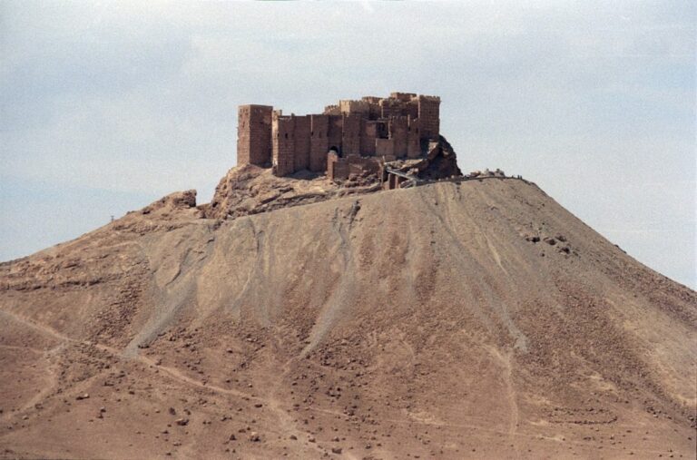
Under Ottoman administration, Palmyra was treated chiefly as a strategic and salt-producing district. A medieval citadel was restored in 1568, and Fakhr-al-Din II renovated the castle later known as Fakhr-al-Din al-Maani Castle. An Ottoman garrison was established in 1867.
Scholarly exploration began to shape modern understanding of the site. Robert Wood visited Palmyra during his 1751 to 1752 expedition and published drawings and descriptions in 1753. Excavations followed under Otto Puchstein in 1902, Theodor Wiegand in 1917, and Daniel Krencker in 1928. During the French Mandate, Henri Seyrig began large-scale excavation and restoration in 1929. The inhabitants of the ancient settlement were relocated to the modern village of Tadmur by 1932, enabling broader archaeological investigation.
Seyrig excavated the Temple of Bel from 1929 and the Agora in 1939 and 1940. Daniel Schlumberger investigated rural sanctuaries in 1934 and 1935. Swiss teams organized by UNESCO excavated the Temple of Baalshamin from 1954 to 1956, while Syria’s Directorate-General of Antiquities and Museums has worked at Palmyra since 1958. French, Swiss, Polish, Syrian, Japanese, American, Italian, Norwegian, and other international teams also investigated the city.
Research continued at the Camp of Diocletian, the Temple of Nabu, the necropoleis, and the Efqa area. Fieldwork and satellite imagery in 2008 identified the irrigation system of the Palmyrene countryside. Much of the residential area remains unexplored, while the necropolis has been extensively excavated. The archaeological site, including the necropolis outside the city walls, was inscribed as the UNESCO World Heritage Site “Site of Palmyra” in 1980 under criteria I, II, and IV. It has been listed as endangered since 2013 because of the Syrian conflict.
Conflict Damage and Conservation
During the Syrian Civil War, military forces used parts of the archaeological area, including the Tomb of the Three Brothers and sections of the North Necropolis. Museum artifacts were partly evacuated to Damascus in 2015, although large objects remained when Islamic State forces entered Palmyra on 21 May 2015.
Islamic State forces used the ancient theater for public executions, mined parts of the site, and destroyed or damaged monuments and tombs. They killed Khaled al-Asaad, Palmyra’s retired antiquities director, on 18 August 2015. The Temples of Baalshamin and Bel, several funerary towers, and the Monumental Arch were destroyed or severely damaged that year.
Syrian forces supported by Russian airstrikes recaptured Palmyra on 27 March 2016. Islamic State forces briefly retook the city in December 2016, damaging the Tetrapylon and the theater, before the city was recaptured in March 2017. Russian de-mining teams then began clearing mines left at the archaeological site.
In 2016, Maamoun Abdelkarim, director of the Syrian antiquities authority, proposed rebuilding the Monumental Arch and the Temples of Bel and Baalshamin through anastylosis, a conservation method that reassembles original architectural elements with clearly distinguishable new material where needed. Russian and Syrian teams surveyed the site in 2016 and 2019. Work on the arch began on 12 November 2021 and remained focused on surveys, documentation, and inventory rather than completed reconstruction. A 6.1-metre replica of its central section, carved from Egyptian marble in Italy using a three-dimensional computer model, was installed in London’s Trafalgar Square on 19 April 2016 and later displayed in several other cities.
After the fall of the Assad government in December 2024, UNESCO began steps toward restoration with the Syrian government and heritage organizations. By June 2026, work remained limited to surveys and damage assessments.
Remains
Palmyra’s archaeological site covers about 80 hectares in an oasis surrounded by palm trees, between the northern and southern Palmyrene mountain ranges and the Syrian Desert. Wadi al-Qubur crosses the area, with the Efqa spring to its south. The earliest settlement stood near the spring, while the later monumental city was concentrated mainly on the northern bank after the wadi was diverted south of the tell beneath the Temple of Bel. The remains combine local Syrian and Mesopotamian traditions with Greek and Roman architectural forms.
Colonnaded City and Religious Buildings
Great Colonnade and Monumental Arch
The Great Colonnade formed Palmyra’s principal street, running for about 1.1 kilometres between the Temple of Bel in the east and Funerary Temple No. 86 in the west. Most of its columns date from the second century CE and stand about 9.5 metres high. At its eastern end, the Monumental Arch linked the street with the Temple of Bel and brought together sections of the colonnade that diverged by about 30 degrees.
The third-century arch had two angled facades that concealed the bend in the street. A large central gateway stood between two smaller openings, and elaborate stone carving covered the structure with plant and geometric reliefs. UNESCO described these reliefs as an outstanding example of Palmyrene art, the local tradition that combined Syrian and Mesopotamian elements with Greek and Roman forms. Restored in the 1930s, the arch was destroyed with explosives in October 2015. Much of its stonework survived and was considered suitable for possible reassembly.
Temple of Bel
Dedicated in 32 CE to Bel, Palmyra’s chief deity, the Temple of Bel occupied a rectangular precinct measuring about 205 by 210 metres. Its enclosure included porticos, a monumental entrance, an altar, basins, a banquet hall, chapels, and a central cella raised on a podium. The sanctuary combined Mesopotamian and Greco-Roman forms.
The cella had a doorway on its long side, niches at its ends, windows, roof merlons, and stairways beside a columned peristyle, a colonnade surrounding a building or courtyard. Ionic and Corinthian forms appeared in the columns. Excavation and earlier restoration revealed major portions of the enclosure and its architectural decoration before Islamic State forces destroyed the temple in August 2015.
Temple of Baalshamin
The Temple of Baalshamin, dedicated to the Syrian deity whose name means “Lord of the Heavens,” developed through several building phases beginning in the late second century BCE. Its altar was built in 115 CE, and the sanctuary was substantially rebuilt in 131. The complex contained a central cella, two colonnaded courtyards, and a six-column vestibule with Corinthian pilasters.
A Swiss expedition organized by UNESCO excavated the sanctuary between 1954 and 1956. Islamic State forces destroyed the temple in 2015.
Other Sanctuaries
The Temple of Nabu was founded during the second half of the first century CE. This small, largely ruined sanctuary had an eastern-oriented plan. Its entrance buildings led through a portico to a podium measuring about 20 by 9 metres. The peristyle cella opened toward an outdoor altar.
The Temple of Al-Lat dates from the second century CE and survives mainly as a podium, several columns, and a door frame. Excavations within the compound recovered the Lion of Al-Lat, a large relief showing a lion protecting a gazelle. A later marble statue identified with Athena was also associated with the sanctuary. The Lion of Al-Lat was restored in 2017 and placed in the National Museum of Damascus.
The Temple of Baal-hamon stood on Jabal al-Muntar above the Efqa spring. Built in 89 CE, it consisted of a cella and a two-column vestibule with an attached defensive tower. A recovered mosaic showed the sanctuary with merlons decorating both the cella and vestibule.
Civic and Military Buildings
Roman Theater and Senate Building
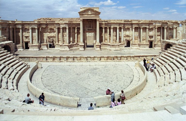
The Roman theater dates from the early first century CE. Nine rows of seating survive, while the original arrangement may have contained sixteen rows with an additional wooden structure. Behind the theater stood a small senate building associated with the city’s civic authorities. Its largely ruined remains include a peristyle courtyard, an apsidal chamber, and rows of seats.
The theater was used by Islamic State forces for public executions during the 2015 occupation and was damaged again during the group’s second occupation of the city.
Agora and Tariff Court
The Agora was a large civic complex measuring about 70 by 80 metres. Eleven entrances opened into an area surrounded by a colonnade and lined with about 200 statue bases. Inscriptions divide parts of the complex among senators, civic officials, soldiers, and caravan leaders, reflecting the groups involved in Palmyra’s public and commercial life.
The adjoining Tariff Court was a large rectangular enclosure. Its original southwestern vestibule was later blocked by a defensive wall, and access then ran through three doors from the Agora. A five-metre stone slab found there preserves the Palmyrene tariff law of 137 CE, which records taxes on goods sold or exported from the city.
Triclinium of the Agora
At the northwest corner of the Agora, the Triclinium was a hall measuring about 12 by 15 metres and capable of accommodating up to 40 people. Continuous Greek-key motifs decorated its interior. It may have served civic rulers before becoming a banqueting hall, although an earlier temple function has also been proposed.
Camp of Diocletian and the Tetrapylon
The Camp of Diocletian occupied the western part of Palmyra. Built by Sosianus Hierocles, Roman governor of Syria under Diocletian, it preserves part of the central principia, the building that housed the legionary standards.
The Tetrapylon stood at the center of the Great Colonnade. Built during Diocletian’s late-third-century renovations, it consisted of a square platform supporting four groups of four columns. Each group carried a 150-ton cornice and a central statue pedestal. Only one of the sixteen columns was ancient; the others were reconstructed in concrete by Syria’s antiquities authorities in 1963. Islamic State forces damaged the monument in 2017.
Walls, Houses, and Water Management
City Walls
Palmyra’s walls developed in several phases. Early protective boundaries used the surrounding mountains as natural barriers and enclosed residential areas, gardens, and the oasis. During the prosperous Roman period, a broad boundary traditionally called the customs wall served as an administrative and taxation limit.
A defensive wall was built hurriedly at the end of the third century, partly with stones reused from funerary monuments. After 273, Aurelian’s rampart, later associated with Diocletian, enclosed about 80 hectares, a much smaller area than the earlier city.
Residential Quarters
Large houses organized around colonnaded courtyards were identified in the northern and northeastern quarters. In the southeast, luxurious mosaic-decorated houses include the House of Achilles and the House of Cassiopeia. Their refined mosaics depict subjects from Greek mythology and were made by artists from Antioch around the end of the third century CE.
Oasis and Irrigation Works
The Efqa spring and the surrounding oasis formed part of Palmyra’s physical and economic setting. The countryside included reservoirs, channels, and other irrigation works. About 48 kilometres southwest of the city, the Harbaqa Dam was built in the late first century CE and could collect approximately 140,000 cubic metres of water.
Funerary Landscape
Funerary Temple No. 86
Funerary Temple No. 86, also called the House Tomb, stood at the western end of the Great Colonnade. Built in the third century CE, it had a six-column portico, vine-pattern carving, and steps descending inside the chamber to a vaulted crypt. It is the only tomb within the city walls and may have been connected with the royal family.
Valley of Tombs
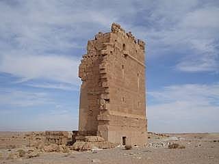
The Valley of Tombs forms a necropolis about one kilometre long west of the ancient walls. More than 50 funerary monuments occupy the valley, including multi-storey tower tombs, underground hypogea, and later temple-tombs. Other cemeteries lay to the north, southwest, and southeast.
Palmyrene tombs contained rows of loculi, individual burial compartments built into the walls, where the dead were placed at full length. Limestone stelae or high-relief busts sealed the openings and also formed part of the wall decoration. Sarcophagi appeared in the late second century, and some tombs contained mummies embalmed in a manner resembling ancient Egyptian practice.
Hypogeum of the Three Brothers
The Hypogeum of the Three Brothers is an underground tomb with particularly rich decoration, including costly blue pigment. Its funerary imagery includes portraits in Greco-Roman or Parthian dress. Figures on sarcophagi wear pleated trousers beneath embroidered tunics, illustrating the detailed clothing and jewelry characteristic of Palmyrene funerary art.