Kraig Castle Ruins: Medieval Fortifications in Austria


Site at a Glance
- Rating
- 4.3
- Popularity
- Very Low
- Country
- Austria
- Primary era
- Medieval
- Eras represented
- Medieval, Early Modern
- Civilizations
- Holy Roman Empire
- Site type
- Military
- Remains
- Castle
On this page14 sections
History
The Kraig Castle Ruins in Austria comprise the remains of Hochkraig and Niederkraig, also known as Neukraig, in the municipality of Frauenstein. Built by medieval rulers and nobles in the Romanesque and Gothic periods, the castles formed part of a defensive chain around the historic ducal city of St. Veit. They stood above Grassen on the southern slope of Kraiger Berg, between Frauenstein Castle and the centre of Kraig.
Origins and the Lords of Kraig
The oldest parts of the complex date from the early twelfth century, while the two principal castles probably arose nearly simultaneously around the transition from the twelfth to the thirteenth century. A separate tower castle on a rocky pinnacle north of Hochkraig was built earlier, in the eleventh century.
The Lords of Kraig first appear in written evidence in 1091, when Dietricus de Kriwig was named. He is regarded as the founder of the family. The Kraigers were feudal holders under the dukes of Carinthia and belonged to the region’s oldest and most influential ministerial families. Ministerials were members of the medieval service nobility who held offices and fiefs from territorial rulers.
From 1249, members of the family served as stewards of the territorial ruler. They later attained the office of governor of Carinthia, with Konrad I von Kraig holding it from 1385 and members of the family returning to the office in the fifteenth century. In 1466, the family was raised to the rank of barons.
Transfer of the Lordship
The Carinthian branch of the family ended in the male line in 1564 with the death of Konrad von Kraig. Some members had previously moved to Bohemia. Through the marriage of Konrad’s sister Barbara, the castles passed to Johann, Count of Hardegg.
Barbara’s daughter Elisabeth later married Georg, Count of Nogaroll, in her second marriage. Around 1566, Nogaroll paid out the two remaining heirs and became sole owner of the lordship after Elisabeth’s death. In 1570, Archduke Karl, the feudal lord, sold the Kraig lordship to Georg von Khevenhüller, while Count Nogaroll retained it as a feudal tenant.
The Protestant Khevenhüllers were forced to surrender their Carinthian estates during the Counter-Reformation, the Catholic revival and political campaign against Protestantism in Habsburg lands. They emigrated in 1628, and Paul Khevenhüller sold the property to Baron Ludwig Grotta von Grottenegg. Several other families held the estate in the following decades. Since 1822, the estate and its surrounding forests have belonged to the Goëss family.
Abandonment and Twentieth-Century History
Hochkraig ceased to be inhabited from the middle of the seventeenth century. Servants of the successive owners continued to live at Niederkraig until the end of the eighteenth century, after which both castles gradually fell into ruin.
In 1934, during the failed July Putsch, an attempted coup by Austrian National Socialists, an eight-by-eight-metre swastika was incorporated into the outer masonry of Hochkraig’s keep. The symbol had been used by the National Socialist German Workers’ Party since the early 1920s, and parts of the inscription “Heil Hitler” were visible several metres below it.
After the Second World War, the owner had the swastika extensively painted over, and it was largely forgotten. It became widely visible again in 2011 after trees were felled during repair work, when the overpainting was found not to have survived. Austrian law prohibited the display of symbols associated with banned organizations, particularly National Socialist organizations. The danger of collapse made removal or concealment unsafe for both the tower and the people undertaking the work.
The Federal Monuments Office shared these concerns and proposed addressing the swastika’s history through an art project and an explanatory plaque. The owner rejected the proposal, and access had already been closed because of the ruin’s unsafe condition. In 2014, Carinthian state conservator Gorazd Živkovič proposed a memorial in the valley along the tower’s sightline, while the Mauthausen Committee Austria called for immediate removal. A project to secure the tower and remove the graphic was planned in 2017. In 2019, the swastika was altered and the “Heil Hitler” inscription was painted over.
The ruins are protected as historic monuments and are closed to entry for safety reasons. The buildings and surrounding forests also form the Kraiger Schlösser Landscape Protection Area in Carinthia.
Remains
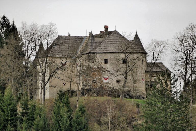
The complex occupies a steep, rocky setting above a narrow valley. Hochkraig stands on a crag almost 100 metres above the valley floor, while Niederkraig forms a more extensive and better-preserved group of buildings. A fifteenth- or sixteenth-century aqueduct, 40 metres long and 10 metres high, links the two castle areas across the valley.
Hochkraig
Keep and Defensive Enclosure
Hochkraig is the smaller of the two principal castles. Its approach came from the northwest, across a level forecourt separated from the castle by a neck ditch about 10 metres wide. From there, a steep path passes through a narrow cleft in the rock and follows the eastern side of the defensive wall to the gate on the north side.
Large sections of the thick-walled Romanesque keep survive. Its rounded corners are enclosed at a distance of only one to two metres by a rubble-stone wall about six metres high. A wall-walk, a passage along the top of a defensive wall, ran along this enclosure. The keep was probably first intended as an outwork of Niederkraig, a supporting fortified position outside the main castle.
Residential and Religious Buildings
A palas, the principal residential building of a medieval castle, was added in the fourteenth century to provide living space. The lower-lying chapel also dates from this period. Remains of the enclosing wall, Gothic residential and service buildings, and the Gothic castle chapel survive among the ruins.
Rock Pinnacle Tower
About 200 metres north of Hochkraig, an isolated rock pinnacle carries the remains of an outwork. This tower castle was built in the eleventh century, before the two principal castle complexes, and is also said to have served as a prison tower.
Niederkraig
Main Castle and Keeps
Niederkraig is considerably better preserved than Hochkraig and includes a much larger group of buildings, most of them dating from the late fourteenth century. The northern of its two square keeps has funnel-shaped openings intended for signaling.
The southern keep is five storeys high and was probably built at the same time as Hochkraig. Gothic additions from the fourteenth and fifteenth centuries surround it, creating a layered complex in which the principal fortified tower remains linked to later construction.
Renaissance Palas
Only a few wall remains survive from Niederkraig’s original three-storey palas, built in the sixteenth century. Its white-marble Renaissance window surrounds show that the residential building had an elaborate design based on classical architectural models.
Saint John Nepomuk Chapel
A round tower on a projecting rock south of the main Niederkraig complex was converted into a chapel in 1730 and dedicated to Saint John Nepomuk, a fourteenth-century Bohemian priest and martyr widely venerated in Central Europe. Attached to the parish church of Kraig as a subsidiary church, it continued to serve as a pilgrimage chapel long after the castles had fallen into decay.
The chapel contains or incorporates numerous Roman-period spolia, meaning architectural elements and sculptural fragments reused from an earlier period. Its seventeenth-century altar carries scrollwork and carved figures dating from the eighteenth century.
Connecting Aqueduct
The complex’s distinctive aqueduct is built with four round arches. Extending for 40 metres and reaching 10 metres in height, it connects Hochkraig and Niederkraig across the narrow valley. The valley was formerly crossed by a Roman road, beneath the structure’s arches.